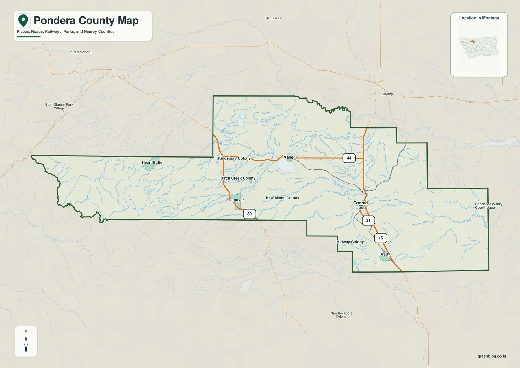
Pondera County stretches from the broad prairie around Conrad and Valier westward into the steep Rocky Mountain Front. Interstate 15 provides the strongest north-south road reference on the eastern side near Conrad and Brady, Route 44 crosses the central county through Valier, and U.S. 89 serves the western corridor around Dupuyer. The terrain-and-water map adds Marias River, Two Medicine River, Birch Creek, Dry Fork Marias River, Lake Frances, and Swift Reservoir. The elevation view shows one of the clearest mountain-to-plains transitions in the county series, with the western edge rising sharply above the central and eastern lowlands. High-resolution JPG versions of the maps are available together in the download ZIP below.
Pondera County’s official offices are based in Conrad, and a Montana Disaster and Emergency Services county profile also identifies Conrad as the county seat. That profile describes a county dominated by Great Plains terrain in the east and much more mountainous country toward the west. The supplied maps reflect the same contrast: Conrad and Valier sit in broad lower terrain, while Heart Butte and the Swift Reservoir side occupy a much more rugged landscape close to the mountain front.
Table of Contents
Conrad and Interstate 15 anchor the eastern plains
On the general county map, Conrad sits near the center of the eastern half. Interstate 15 runs north-south through the broader Conrad-Brady corridor, and Route 21 appears as another important local reference around Conrad. Roads are generally straighter and more widely spaced here than in the western mountain section.
Brady lies south of Conrad, with Midway Colony nearby. A Pondera County Courthouse label appears farther east on the map, but official county information places the county government in Conrad. Map labels are best used for geographic orientation, while administrative details should be checked through official county sources.
The eastern half contains broad low terrain crossed by many shallow drainage lines. The county map is useful for road orientation, but current construction, winter conditions, and temporary closures require up-to-date travel information.
Valier and Route 44 divide the central prairie
Valier lies northwest of Conrad in the central part of the county, with Route 44 crossing east-west. Kingsbury Colony and Birch Creek Colony appear farther west and southwest, while New Miami Colony provides another label between the Dupuyer and Conrad sides.
Dupuyer sits farther west along U.S. 89. The highway continues north and south through the foothill corridor and provides the clearest road reference before the county reaches the rugged western extension. Heart Butte appears northwest of Dupuyer in the long western section.
The county boundary becomes narrower and more irregular toward the mountains. Road density falls, streams become more numerous, and relief increases rapidly. This transition is visible on the general map but becomes much clearer on the terrain-and-water and elevation maps.
Conrad and Valier are the two ranked cities
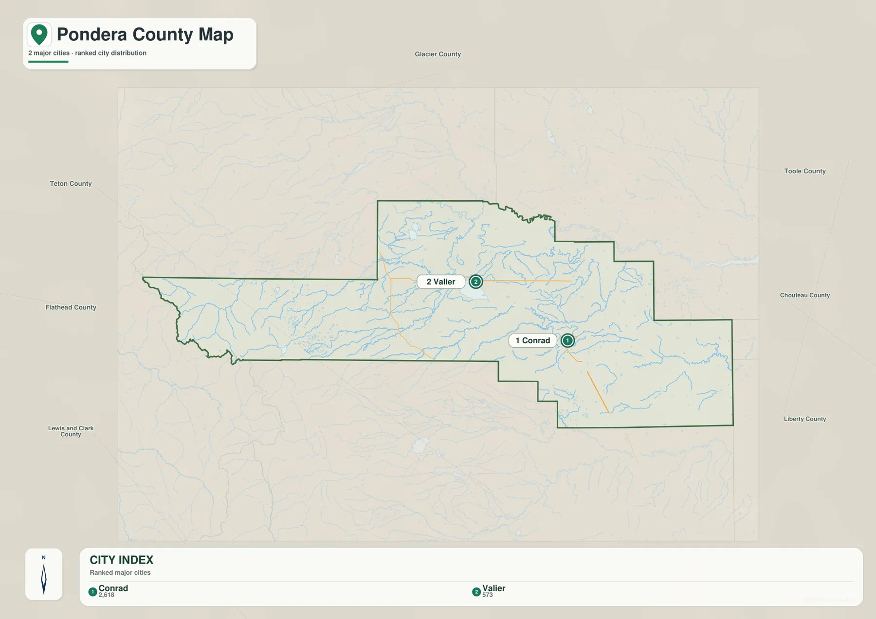
The city map ranks two places: Conrad and Valier. Its CITY INDEX lists Conrad at 2,618 and Valier at 573. These figures are embedded in the supplied map and should not be treated as guaranteed current population estimates. Current demographic totals should be checked through recent U.S. Census Bureau data.
Conrad occupies the eastern half of the county, while Valier lies farther northwest. Surrounding labels include Glacier, Toole, Chouteau, Liberty, Lewis and Clark, Flathead, and Teton counties, placing Pondera County between open plains and the Rocky Mountain Front.
No connector line or mileage label is printed between Conrad and Valier. The visual spacing should therefore be treated only as a location reference, not as straight-line distance or driving mileage. Actual trips should be checked on the general map and with current navigation information.
Marias River and Two Medicine River organize the northern waters
Marias River is the dominant water reference along the northern side of the county. Two Medicine River approaches from the west-central area and follows another broad lower corridor toward the Marias system.
Alkali Lake appears south of Two Medicine River, while Lake Frances lies southwest of Valier. These water bodies stand out clearly in the open prairie and provide useful references for the central-northern county.
The terrain-and-water map is intended for geographic reference. It does not establish flood zones, water depth, parcel boundaries, water rights, navigation conditions, or safe stream crossings. Current water and access conditions should be checked through the appropriate official sources.
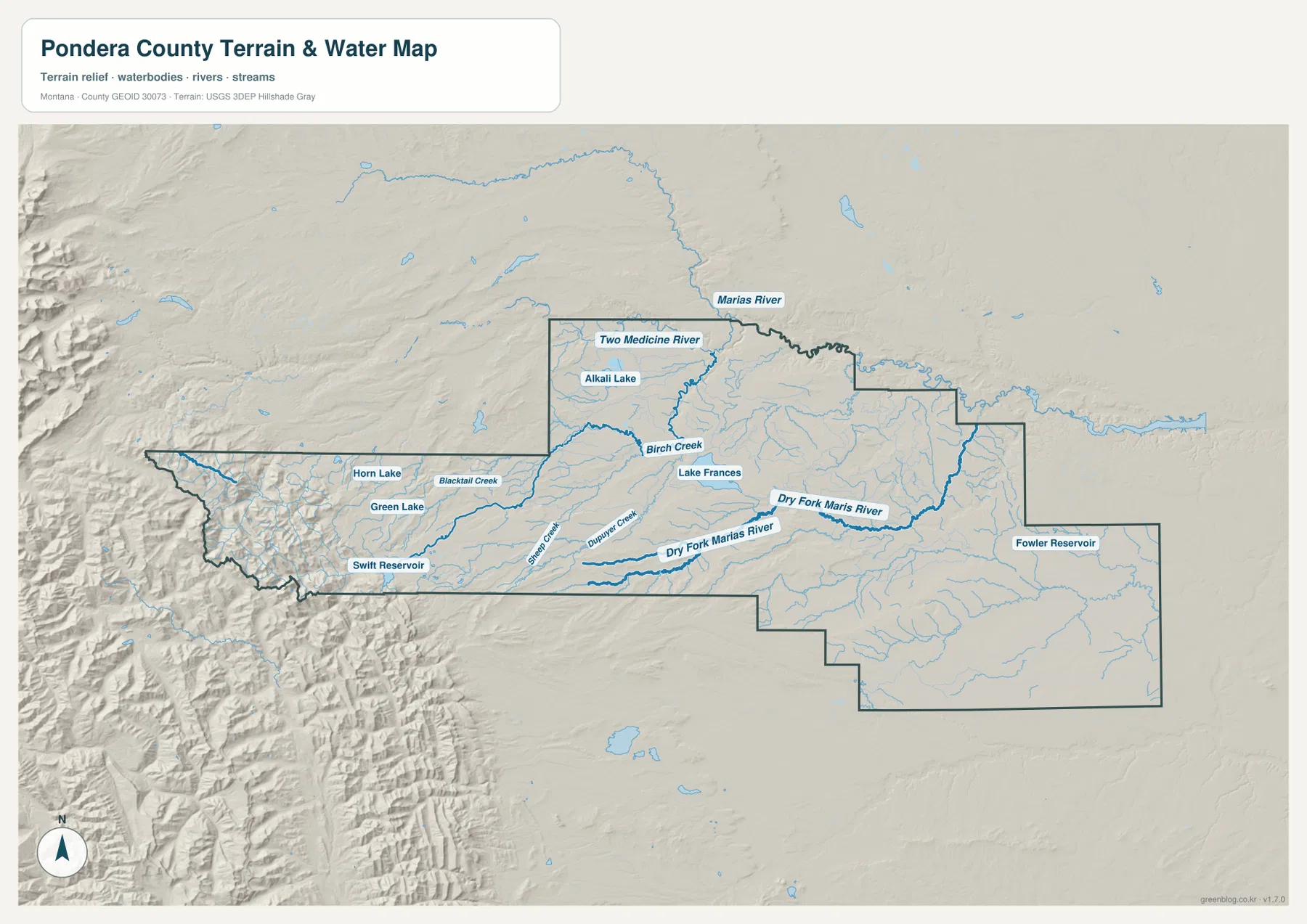
Birch Creek and Swift Reservoir mark the mountain-front side
Birch Creek is one of the clearest streams descending from the western mountain front. Blacktail Creek and Sheep Creek occupy nearby valleys, while Dupuyer Creek provides another lower route close to the Dupuyer side. These streams make the foothill transition much easier to understand than the road map alone.
Swift Reservoir sits near the southwestern mountain edge and is one of the county’s strongest water landmarks. Green Lake and Horn Lake lie farther north within the same rugged western section, where closely spaced ridges and valleys dominate the terrain.
Dry Fork Marias River becomes the major named channel toward the southeastern interior, and Fowler Reservoir appears farther east. Together, these features show how the county changes from steep mountain drainage in the west to broader, shallower channels across the plains.
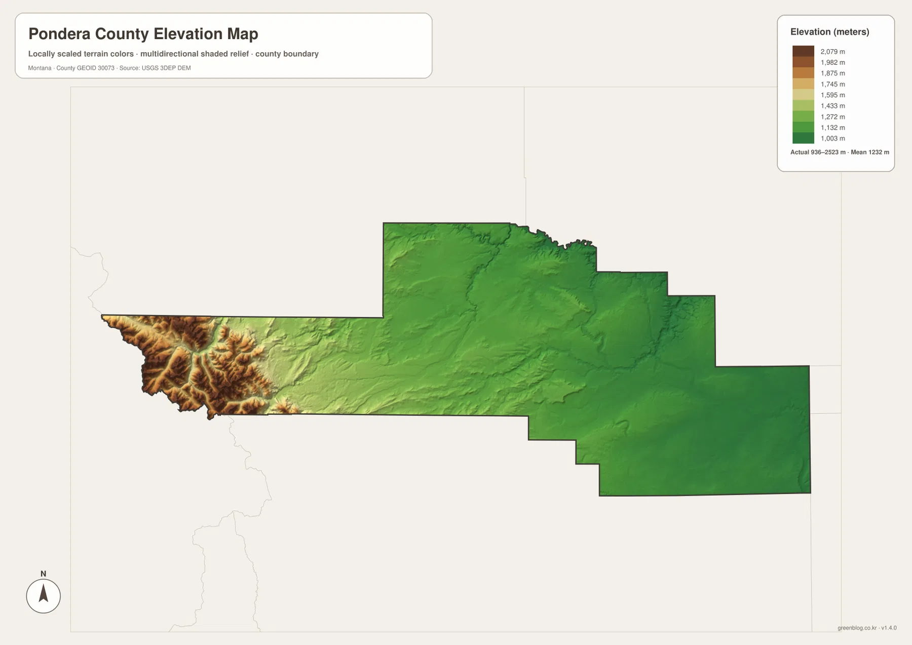
Elevation ranges from about 936 to 2,523 meters
The elevation map reports an actual Pondera County range of about 936 to 2,523 meters, with a mean elevation near 1,232 meters. Conrad, Valier, and most of the eastern and central county appear in green, indicating broad lower terrain.
The western extension rises abruptly into yellow, brown, and dark-brown mountain terrain. The Heart Butte-Swift Reservoir side contains the county’s highest relief, with narrow valleys cut between steep ridges. Birch Creek and other streams descend eastward through these lower passages.
Around Dupuyer, the mountain front transitions quickly into open prairie, and the terrain continues to lower toward Conrad and Brady. The elevation map is intended for county-wide comparison only and should not be used as survey-grade or engineering-grade data for a specific property.
Conrad, Valier, and the mountain-front waters form a simple framework
A practical way to read Pondera County is to begin with Conrad and Interstate 15 on the east, then move west to Valier and Route 44. U.S. 89 and Dupuyer provide the next reference before the county reaches the much more rugged Heart Butte and Swift Reservoir side.
Water features provide another layer. Marias River and Two Medicine River organize the north, Birch Creek and Lake Frances help with the center-west, and Swift Reservoir marks the mountain side. Dry Fork Marias River and Fowler Reservoir provide useful references across the southeastern plains.
The WebP images embedded in the article are convenient for quick browsing. The high-resolution JPG files in the ZIP are better for printing or enlarging small road, river, creek, and lake labels. Because these are static reference maps, current road access, reservoir levels, and mountain conditions should be checked through current official information.
Frequently Asked Questions
Does the city map show the distance between Conrad and Valier?
No. The city map ranks and locates Conrad and Valier but does not print a connector line, straight-line distance, or road mileage between them. Use the general county map and current navigation information for an actual trip.
Where is the highest terrain in Pondera County?
The highest terrain is concentrated along the western Rocky Mountain Front around the Heart Butte and Swift Reservoir side. Conrad, Valier, and most of the central and eastern plains are much lower.
Can the 936–2,523 meter elevation range be used for a property or engineering project?
No. The range is a county-wide reference for comparing the lower prairie with the high western mountains. Precise site elevations should come from an authoritative source such as the USGS 3D Elevation Program and, when necessary, a professional survey.
Map File Information
Download the Pondera County county, city, terrain-and-water, and elevation maps as high-resolution A3 JPG files.
- Included Files: county map, city map, terrain and water map, elevation map
- File Type: ZIP containing 4 JPG files
Related Maps
Sources and References
County government information is available from the official Pondera County website. A Montana Disaster and Emergency Services Pondera County profile identifies Conrad as the county seat and describes the contrast between the eastern Great Plains and the mountainous western side.
Boundary and road-reference data can be checked through U.S. Census Bureau TIGER/Line Shapefiles. Hydrographic data are available from USGS National Hydrography, and elevation data through the USGS 3D Elevation Program.
Green Map creates custom-edited map images using open geographic data sources such as geoBoundaries, Natural Earth, OpenStreetMap, and government open data. These maps are edited visual materials, not raw data files, and are provided for education, documents, presentations, and graphic reference.