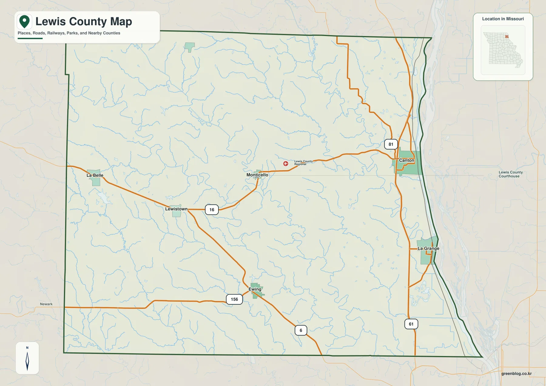
Lewis County occupies the far northeastern corner of Missouri, where the entire eastern edge meets the Mississippi River. Canton and La Grange sit close to the river, while Monticello, Lewistown, La Belle, and Ewing are scattered across the rolling interior. The Middle Fabius River, North Fabius River, Wyaconda River, and many smaller tributaries cut deep, branching valleys through the farm country. The general map shows Routes 16, 156, 6, and 81 along with U.S. 61, while the elevation layer ranges from about 142 to 229 meters. High-resolution JPG map files are available together in the ZIP below for printing or offline use.
The county is easiest to understand by starting with the Mississippi River side and then moving west. Canton and La Grange occupy the low eastern edge, Monticello sits inland on the Route 16 corridor, and La Belle marks the western side. The elevation map shows a broad contrast between low river bottoms and higher western hills, while the water layer reveals how the Fabius branches carve narrow green corridors through those uplands.
Table of Contents
Canton and La Grange define the Mississippi River side
Canton lies in northeastern Lewis County near the Mississippi River, with U.S. 61 and Routes 16 and 81 providing the clearest road references. La Grange is farther south along the same river side and is also closely tied to the U.S. 61 corridor. Together, the two towns create the county’s strongest concentration of settlement along the eastern boundary.
Canton also occupies higher ground immediately above the river lowland. Culver-Stockton College describes its 140-acre Canton campus as sitting on ‘the Hill’ overlooking the Mississippi River. That description matches the elevation map, where the broad green floodplain is immediately bordered by higher and more irregular terrain west of the river.
Monticello is small on the city map but central to county government
Monticello lies inland from Canton on the Route 16 corridor between the eastern river towns and the western half of the county. Its developed footprint is modest, yet it serves as the county seat. The official Lewis County website lists the courthouse and county offices at 100 East Lafayette Street in Monticello.
Lewis County’s history page states that the county was organized from Marion County in 1833 and named for Meriwether Lewis of the Lewis and Clark Expedition. The present courthouse dates to 1875. Those facts make Monticello a useful reminder that administrative importance does not always match the size or city-index ranking shown on a map.
The ranked city layer stretches from the river to the western county line
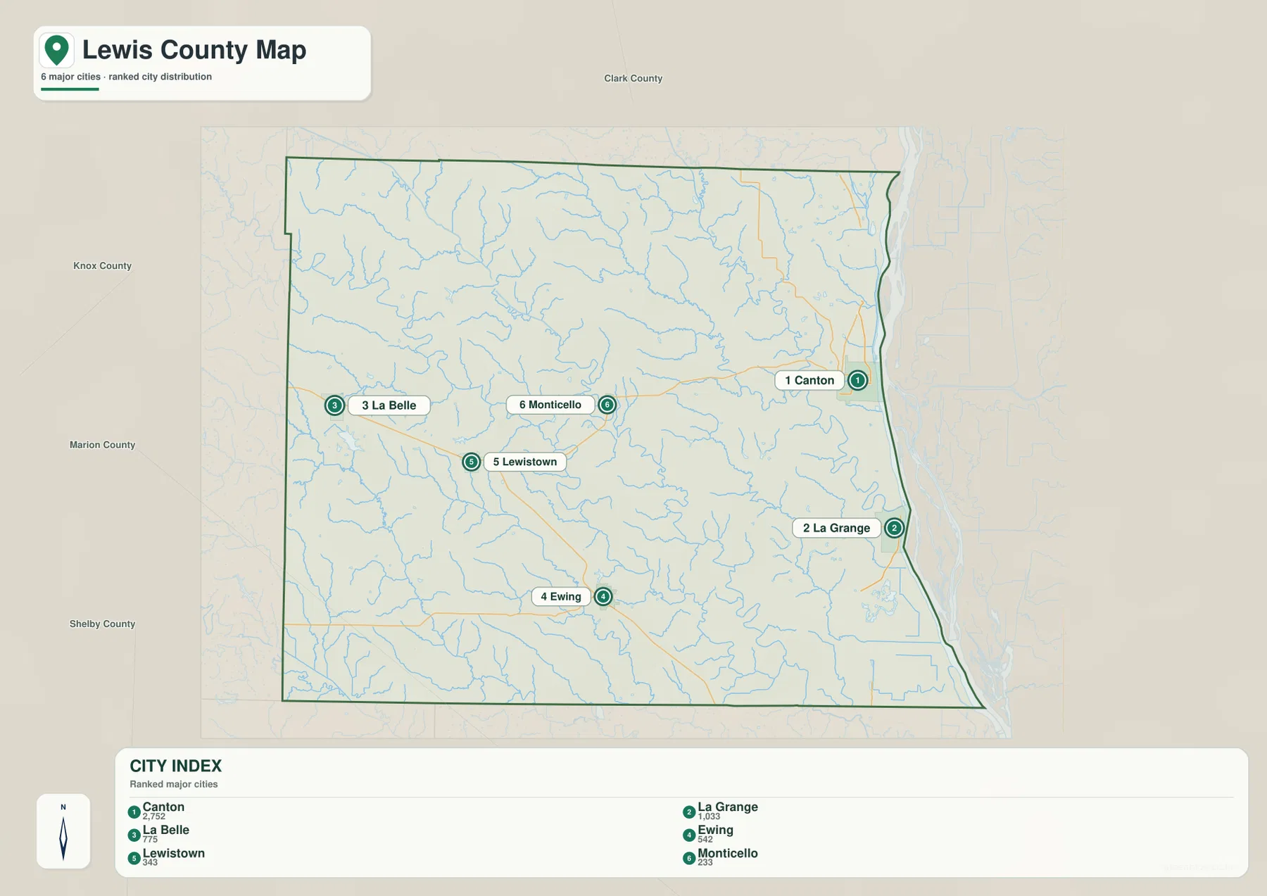
The city distribution map ranks Canton first, La Grange second, La Belle third, Ewing fourth, Lewistown fifth, and Monticello sixth. The CITY INDEX values are 2,752 for Canton, 1,033 for La Grange, 775 for La Belle, 542 for Ewing, 343 for Lewistown, and 233 for Monticello. These values belong to the supplied mapping dataset and should not be presented as current official population estimates.
The geographic spread matters more than the numbers. Canton and La Grange occupy the Mississippi River side, La Belle is far west, Lewistown is west-central, Ewing lies in the southern interior, and Monticello sits slightly east of center. The numbered markers indicate rank rather than driving distance or travel time.
The Mississippi River forms the county’s broadest lowland
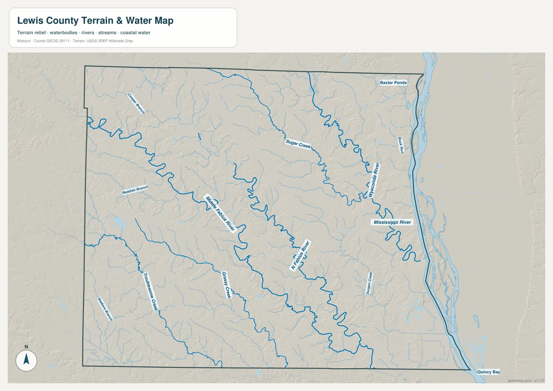
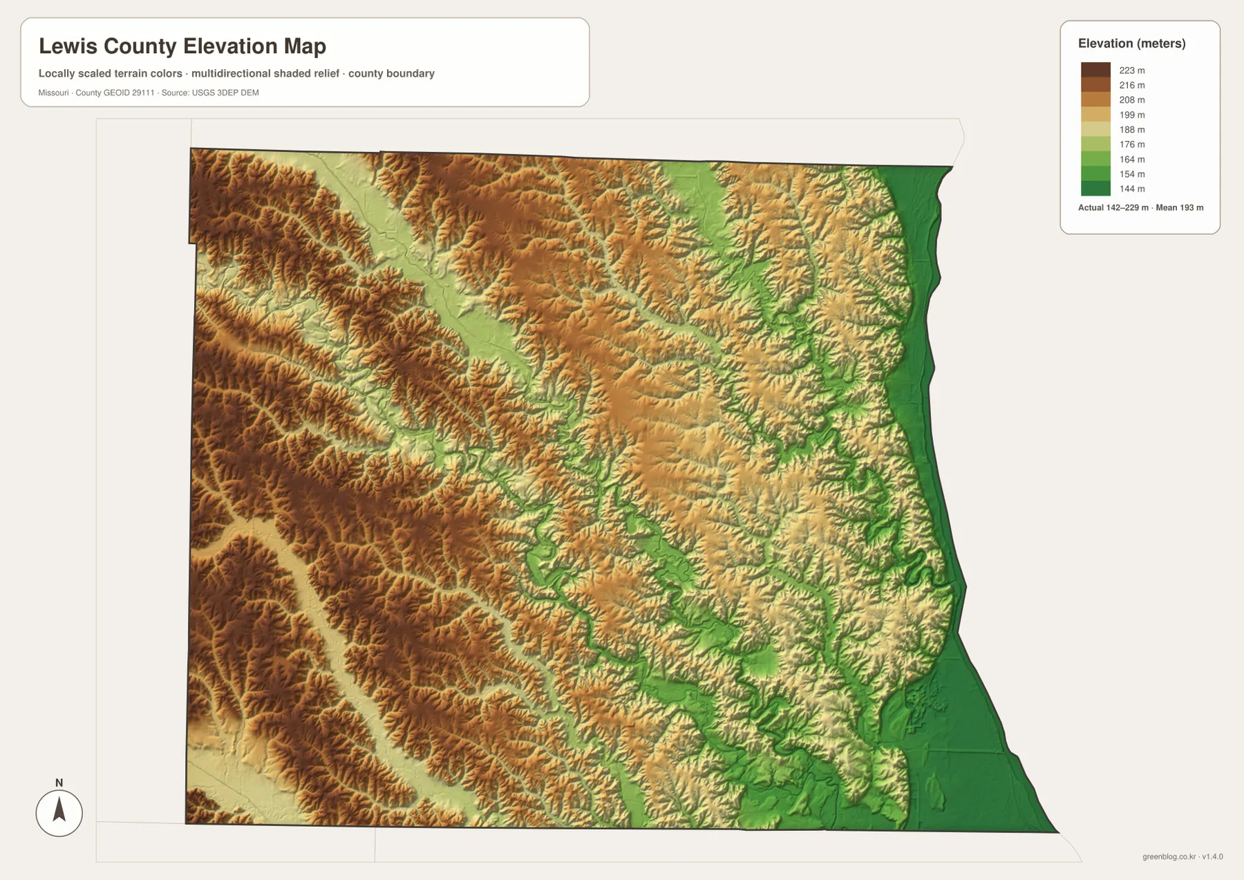
The Mississippi River follows the entire eastern edge of Lewis County and creates the largest continuous low corridor on the terrain map. The elevation layer shows the river side in the darkest green, especially around the broad bottomlands south of Canton and near La Grange. Higher ground rises quickly just to the west.
Buck Run and a number of smaller tributaries descend from the interior toward the river, and Quincy Bay appears near the southeastern edge of the water map. The layer is useful for geographic orientation, but it is not a live river-stage, flood-warning, or navigation product. Current river conditions require official real-time sources.
Middle Fabius River cuts a long valley through the western interior
Middle Fabius River is one of the dominant inland waterways. It enters from the northwest and winds diagonally across the county, receiving numerous short tributaries. Redfish Branch and Grassy Creek are among the named streams that help define the lower corridors west and south of the river.
On the elevation map, the Middle Fabius appears as a long green valley through much higher brown and tan hills. The landscape around La Belle and Lewistown therefore has far more relief than an agricultural road map might suggest. Roads frequently cross or follow these valleys, making the river system a useful guide to the western half of the county.
North Fabius River and Wyaconda River shape the eastern interior
North Fabius River bends through the east-central county before continuing south. Sugar Creek descends from the north, while Wyaconda River follows another major valley closer to the Mississippi side. Having several substantial drainage systems close together produces a tightly divided landscape west of Canton and around the Monticello corridor.
Missouri Department of Conservation identifies Lewis County as part of the broader Fabius River watershed. Tolona Access, a 176-acre public area in Lewis County, sits along the Middle Fabius River and can be reached from the Ewing area. That site provides a real-world reference for the river valleys shown on the county map.
Troublesome Creek and Grassy Creek add depth to the southwestern hills
Troublesome Creek is one of the stronger named streams in the southwestern part of the terrain map, while Grassy Creek occupies another long drainage farther east. Numerous smaller branches join them and break the country west and south of Ewing into many short ridges.
This is different from the broad Mississippi bottomland. In the southwest, low ground is confined to narrow green creek valleys separated by higher tan and brown ridges. The elevation and water layers therefore add important detail to an area that can otherwise look like uniform farmland on a simple road map.
Elevation ranges from about 142 to 229 meters
The elevation layer reports an actual mapped range of approximately 142 to 229 meters, with a mean near 193 meters. The broadest low ground follows the Mississippi River along the eastern boundary. The western and northwestern county contains much more extensive brown high ground, while the Fabius and Wyaconda valleys cut green corridors through the middle.
Canton offers one of the clearest local contrasts because high ground lies immediately beside the river bottom. Middle Fabius and North Fabius create lower routes inland, but their valleys are narrow compared with the Mississippi floodplain. The map is appropriate for county-scale terrain comparison and should not be used as survey-grade or engineering-grade elevation data.
Wakonda State Park gives the La Grange river plain a distinctive lake landscape
Wakonda State Park lies near La Grange on the eastern side of Lewis County. Missouri State Parks explains that the site developed around deep sand and gravel deposits left by glacial processes and later mined for road material. Gravel extraction eventually created six lakes that became central features of the park.
The park now supports fishing, boating, swimming, camping, and nature observation, and it also contains a rare sand prairie. This history adds an unusual local layer to the Mississippi River bottomlands: the same low eastern landscape shown on the county map also contains a group of human-created lakes and distinctive sand habitats shaped by earlier quarrying.
Culver-Stockton College connects Canton with the high ground above the river
Culver-Stockton College occupies high ground in Canton and describes its campus as overlooking the Mississippi River. The institution was chartered in 1853 and began classes in 1855. During the Civil War, its main building was used at different times by Union troops as a hospital, prison, and barracks before the college resumed normal operations after the war.
That history is tied closely to Canton’s geography. The town sits where the river lowland meets a higher interior, giving the college’s hilltop setting a direct relationship to the terrain visible on the elevation map. The contrast between the river edge and the campus side is one of the most recognizable features of eastern Lewis County.
Choosing the right downloadable map
Use the general county map for Canton, La Grange, Monticello, the western towns, and the main roads. The ranked city layer is best for comparing the six leading communities across the county. The terrain-and-water map is more useful for the Mississippi River and the Fabius and Wyaconda systems, while the elevation layer clearly separates the low eastern floodplain from higher western hills.
The ZIP contains A3 high-resolution JPG files matching the map themes shown on the page. They are useful when smaller place names and stream labels need to be enlarged or when a printed reference is more convenient. These files do not replace live navigation, flood warnings, legal property boundaries, river-navigation information, or professional elevation surveys.
Frequently Asked Questions
Is Canton or Monticello the county seat of Lewis County?
Monticello is the county seat. Canton is the largest city on the supplied ranked-city map and an important Mississippi River community, but the official Lewis County government site places the courthouse and county administration in Monticello.
Are the CITY INDEX numbers current population figures?
No. The values shown for Canton, La Grange, La Belle, Ewing, Lewistown, and Monticello belong to the supplied map dataset. Current official population estimates should be checked separately with the U.S. Census Bureau or another current statistical source.
Where is the lowest terrain in Lewis County?
The supplied elevation map shows the Mississippi River corridor along the eastern boundary as the broadest low area. The Fabius and Wyaconda river valleys are also lower than the surrounding hills, while the west and northwest contain higher terrain.
Map File Information
Download the map files associated with this page for reference, printing, and compatible visual projects.
- Included Files: Use only the versions confirmed in the article and supplied images
- File Type: Use the confirmed download contents
- Intended Use: Printing, education, presentations, and map-based projects
Related Maps
Sources and references
- Lewis County, Missouri – Official Website – county government in Monticello
- Lewis County – About – county organization, Meriwether Lewis, the 1875 courthouse, and local towns
- Missouri State Parks – Wakonda State Park – lakes and recreation near La Grange
- Culver-Stockton College – About – Canton campus and its setting above the Mississippi River
- Missouri Department of Conservation – Tolona Access – public access along the Middle Fabius River
- U.S. Census Bureau TIGER/Line Shapefiles – county boundary and road data
- USGS 3D Elevation Program – elevation data
Green Map creates custom-edited map images using open geographic data sources such as geoBoundaries, Natural Earth, OpenStreetMap, and government open data. These maps are edited visual materials, not raw data files, and are provided for education, documents, presentations, and graphic reference.