Cape Girardeau County sits in southeastern Missouri with the Mississippi River defining its eastern side and two prominent urban reference points inside the county: Cape Girardeau on the river side and Jackson farther inland. Interstate 55 and U.S. 61 provide the clearest north–south road references, while Routes 34, 72, 74, 77, and 177 help locate smaller communities and different parts of the county. The four maps on this page are also available as high-resolution JPG originals in one ZIP download near the end of the article.
Start with the county sheet when roads and communities matter most. The city sheet makes Cape Girardeau, Jackson, Delta, Gordonville, Oak Ridge, and Allenville easier to compare without the heavier road labeling. For the physical landscape, the water map brings named streams and lakes forward, while the elevation map makes the low Mississippi edge and nearby ridges immediately visible. Moving between these views keeps the same places in context instead of turning each map into a separate list of features.
One of the strongest geographic contrasts is between the narrow low ground beside the Mississippi and the ridged interior immediately west of it. The supplied elevation legend reports an actual range of about -1 to 247 meters with a mean near 139 meters. Higher terrain also appears across much of the west and northwest, while broader low colors spread through parts of the southwest around Delta and Allenville. That variety makes Cape Girardeau County more than a simple river plain or a uniform upland county.
Table of Contents
Follow U.S. 61 and I-55 between Jackson and Cape Girardeau
Jackson is a useful place to begin with the general county map. U.S. 61 approaches from the north near Pocahontas and New Wells, passes through the Jackson area, and continues south. I-55 runs on a broader north–south corridor just to the west before bending toward the Cape Girardeau side of the county. West of Jackson, Route 72 points toward Millersville and connects with the road system extending toward Route 34. Southbound local routes lead toward Gordonville and Dutchtown.
Cape Girardeau occupies a different setting. The city spreads along the eastern side close to the Mississippi River, and Route 74 crosses the southern part of the urban area before continuing west toward Dutchtown. Route 177 is visible farther north near the river side. The map makes it clear that Cape Girardeau and Jackson are closely connected but are not the same center: Cape Girardeau is the large river-side city, while Jackson sits inland where several important roads can be compared in one view.
The smaller communities give the rest of the county its shape. Old Appleton lies near the northern boundary, with New Wells and Pocahontas farther south. Oak Ridge and Millersville occupy the western half. Whitewater, Allenville, and Delta sit in the southwest, where Routes 25 and 77 provide useful road references. Looking at these places prevents the map from becoming only a Cape Girardeau–Jackson diagram and makes the rural portions of the county easier to place.
The boundary is also visually distinctive. The eastern edge follows the sweeping Mississippi River, while the southern edge has several stepped segments. Northern and western sides appear simpler by comparison. This sheet is useful for orientation, road context, and general county geography, but it should not be used as a parcel survey or a legal boundary instrument. Property and jurisdiction questions require current county GIS records, surveys, and other official sources.
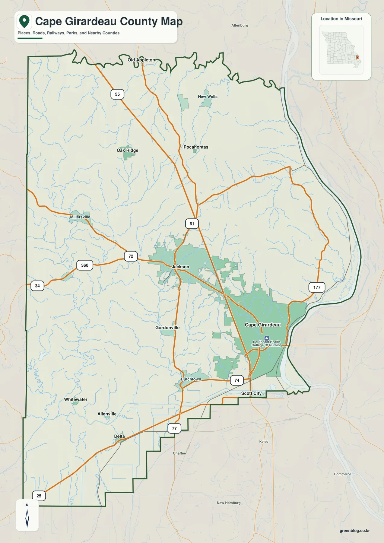
Jackson works well as the first landmark because U.S. 61, Route 72, and nearby I-55 make it easy to connect the middle of the county to other places. From Jackson, Cape Girardeau lies east toward the Mississippi, Pocahontas and Old Appleton sit farther north, Millersville is west, and Delta is down in the southwest. Those reference points give the road map a clear shape before smaller labels are added. Because the map is static, current construction, closures, detours, and traffic still need to be checked with live transportation sources.
The ranked city sheet separates two large centers from the southwest communities
The city map removes most of the highway detail and focuses on six selected communities. In the values printed on the supplied sheet, Cape Girardeau is ranked first at 40,344 and Jackson second at 15,659. Delta follows at 532, Gordonville at 473, Oak Ridge at 298, and Allenville at 127. These numbers belong to the dataset used to make this particular map and should not be treated as permanently current official population estimates.
Location matters as much as rank. Cape Girardeau occupies the eastern side beside the Mississippi River, while Jackson sits farther west in the interior. Gordonville is south of Jackson, and Oak Ridge is separated to the northwest. Delta and Allenville are in the southwest, well away from the largest urban area. The sheet therefore shows a county with two dominant centers and several much smaller communities scattered in different directions rather than a simple ring around one central city.
This is a ranked location map, not a connector-distance map. It does not draw lines between the six communities and does not give either straight-line or driving mileage. If the question is how far Cape Girardeau is from Delta by road, the city sheet cannot answer it. Use the general county map to identify the relevant highways and a current navigation source for exact routing and travel time.
The city values can also change with new Census counts or estimates. When an exact current population is important, check the U.S. Census Bureau or the relevant local government. For a classroom, presentation, or quick location comparison, the city sheet works well because the six selected places are easy to see without the visual clutter of the full road network.
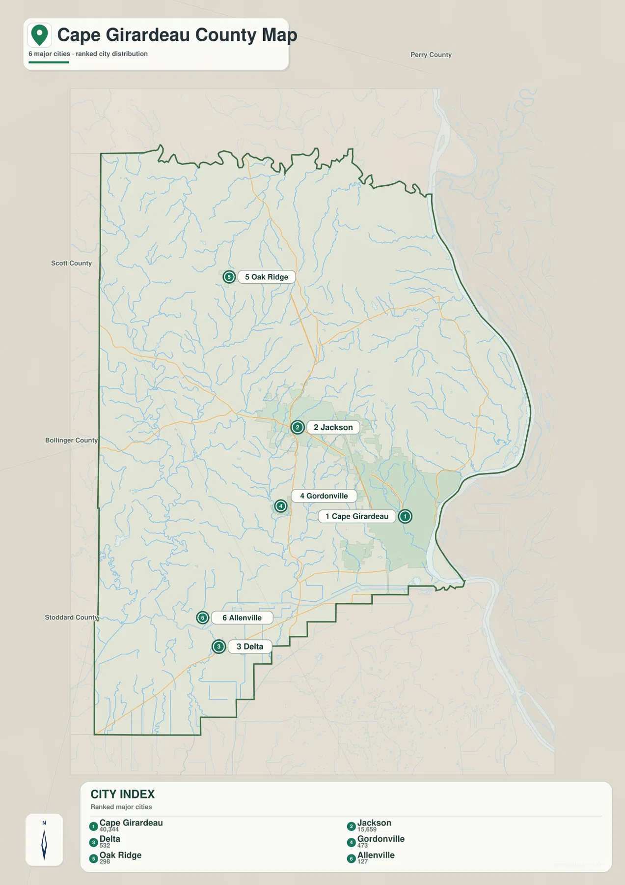
Pairing the city sheet with the general map is often more useful than trying to force every detail onto one image. The city map quickly answers where the selected communities are located. The general map then adds I-55, U.S. 61, Routes 25, 72, 74, 77, and 177, plus smaller named places. That separation keeps both sheets readable.
Mississippi River on the east, Whitewater River and interior creeks to the west
The terrain-and-water map makes the Mississippi River impossible to miss. It forms the long eastern edge of the county, with shorter streams descending toward it from the interior. Cape La Croix Creek is labeled near Cape Girardeau, and Iron Creek appears farther north along the river side. Shaded relief shows that those tributaries cut through ridged terrain before reaching the much lower river margin.
Whitewater River is the strongest western water reference. It runs through the western side of the county, and Byrd Creek joins the surrounding network of smaller channels. Cedar Lake, Cypress Lake, and Lake Girardeau are also labeled in the west and southwest. This side of the county looks very different from the Mississippi edge: instead of one dominant river defining the boundary, numerous streams and lakes occupy separate valleys among the uplands.
Several additional names help fill in the center of the county. Hubble Creek runs through the central area, while Williams Creek and Lake Hollenbeck appear farther east. Apple Creek and Caney Fork are labeled in the northwest, and Crooked Creek appears toward the southwest. These features show why a two-river summary would miss much of the local geography. Smaller valleys divide the interior and connect different sections of the county to larger rivers and downstream systems.
Relief shading gives the water names useful context. Tributaries on the eastern side descend toward the low Mississippi River strip. In the west, smaller streams thread through narrower valleys between higher ridges. Toward the southwest, lower terrain broadens and the relief becomes less sharply ridged in several places. The terrain-and-water sheet is especially helpful when a named creek is difficult to understand on the road map alone.
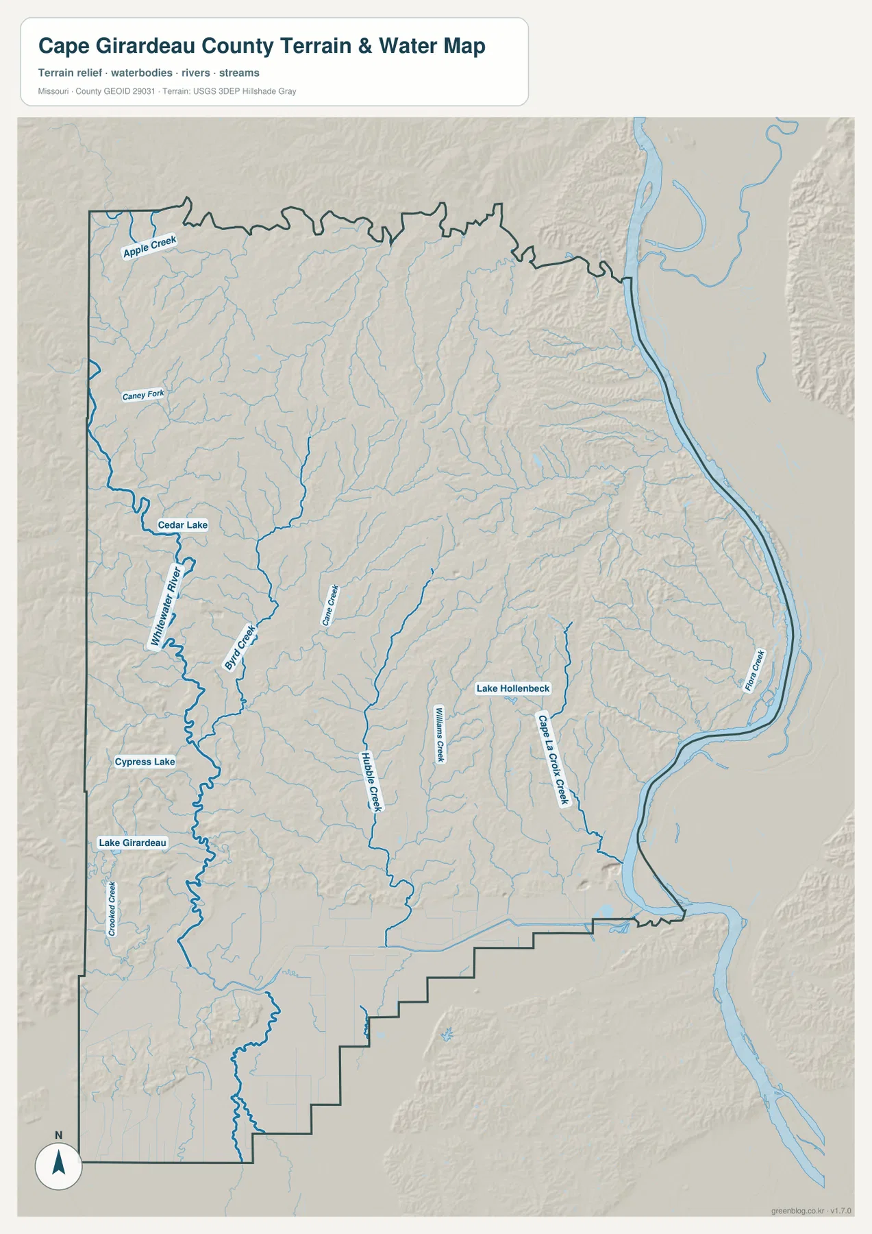
This map is a general geographic reference, not a flood-hazard, navigation, or legal-water-boundary product. A blue river or creek does not define a FEMA flood zone, and a named water body does not establish public access or navigability. Property, insurance, development, boating, and emergency decisions require current official flood studies, local regulations, and site-specific information.
River lowlands sit beside steep-looking ridge country
The elevation map provides the clearest summary of Cape Girardeau County relief. Its legend reports an actual range of about -1 to 247 meters with a mean near 139 meters. Green represents relatively low terrain within this locally scaled map, while yellows and browns mark higher ground. The Mississippi River side contains a narrow green lowland, but high ridges rise close behind it in many places, creating one of the most distinctive contrasts on the sheet.
The eastern interior is therefore not a flat plain. North and northeast of Cape Girardeau, tributary valleys cut through warm-colored ridges on their way to the Mississippi. In several areas the low river strip and higher terrain are only a short distance apart. The road map shows the river as a boundary, but the elevation sheet reveals how quickly the landscape changes after leaving the river margin.
The west and northwest are also strongly textured. Whitewater River and smaller tributaries form green corridors between higher ridges. Farther south and southwest, lower colors spread across a broader area near Delta and Allenville. Central creek valleys divide the uplands into smaller ridge blocks, so the county never looks like one uniform plateau. The total range of more than 200 meters describes county-wide relief and should not be mistaken for the height of a single hill.
Community locations become easier to understand against this surface. Cape Girardeau lies where the river lowland meets the eastern uplands. Jackson is inland on more moderate ground away from the narrow Mississippi-side strip. Delta and Allenville occupy the broader lower terrain of the southwest. Comparing the city sheet with the elevation map adds physical context to places that otherwise appear only as points and labels.
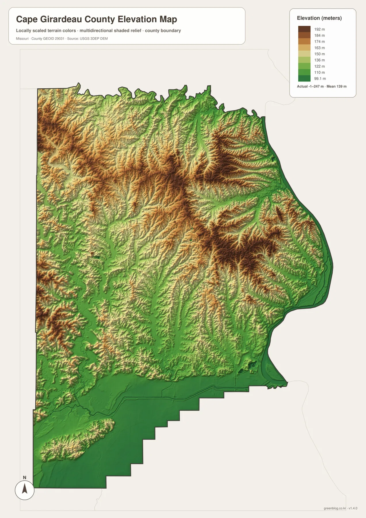
The colors are scaled to show differences within Cape Girardeau County. Brown does not mean nationally high mountain terrain, and green does not automatically mean wetland or official floodplain. The elevation surface is intended for county-scale geographic understanding. Surveying, engineering design, drainage calculations, and construction work require detailed elevation data or professional site measurements.
Match the road, water, and elevation sheets to the question
If you are trying to place Jackson and Cape Girardeau within the county, the general map is the easiest starting point because I-55, U.S. 61, Route 74, the Mississippi River edge, and smaller communities remain visible together. Once that framework is clear, the ranked city sheet is useful for a cleaner comparison of the six selected places. It removes much of the road detail without changing their relative positions.
For physical geography, the terrain-and-water and elevation sheets work best as a pair. Find the Mississippi River, Whitewater River, Cape La Croix Creek, Hubble Creek, and Byrd Creek on the water map, then look at the same areas on the elevation surface. Creeks repeatedly occupy lower green corridors, while nearby ridges rise in warmer colors. The Mississippi side is particularly revealing because a very low river margin sits immediately beside noticeably higher terrain.
The WebP images on the page are optimized for browser viewing. The downloadable ZIP contains the same four subjects as original 2572-by-3638-pixel JPG files, which are better for enlarging small labels, checking stream names, and preparing printed material. These remain general-reference maps rather than live operational products, so current road closures, parcel ownership, legal boundaries, flood insurance determinations, and precise point elevations should always be checked with the appropriate official source.
Frequently Asked Questions
Should I begin with Cape Girardeau or Jackson when reading the maps?
Begin with Cape Girardeau when your main interest is the Mississippi River side and the largest urban area. Begin with Jackson when you want to compare U.S. 61, I-55, and the interior roads. Finding both cities first and then checking Old Appleton and Pocahontas to the north, Millersville to the west, and Delta to the southwest gives a quick framework for the whole county.
Does green terrain beside the Mississippi River mean an official flood zone?
No. Green indicates relatively low elevation within the local color scale used for this county. It is not a FEMA flood-zone symbol. River bottoms and stream valleys are often lower than nearby ridges, but regulated flood risk depends on hydrology, rainfall, levees, drainage, and official mapping. Use current FEMA and local government information for property, insurance, development, and safety decisions.
Are the six city values a complete and permanently current population ranking?
No. The ranked sheet compares Cape Girardeau, Jackson, Delta, Gordonville, Oak Ridge, and Allenville using the values selected for this map package. It does not list every settlement, and population values can change when new Census estimates or counts are released. Check U.S. Census Bureau QuickFacts and relevant local-government sources when a current official figure is required.
Map File Information
The ZIP contains the original high-resolution JPG files for the county map, ranked city map, terrain-and-water map, and elevation map shown in this article. The originals are larger than the on-page WebP images and are useful for close viewing, enlarged labels, and print preparation.
- Included Files: 4 maps
- File Type: JPG
Related Maps
Sources and References
- Cape Girardeau County official website: official county government and public-information source.
- U.S. Census Bureau QuickFacts – Cape Girardeau County: current official county population and statistical reference.
- U.S. Census Bureau TIGER/Line Shapefiles: authoritative geographic boundary reference data.
- USGS National Hydrography: official river, stream, lake, and water-feature reference.
- USGS 3D Elevation Program: official elevation and terrain-surface reference.
Green Map creates custom-edited map images using open geographic data sources such as geoBoundaries, Natural Earth, OpenStreetMap, and government open data. These maps are edited visual materials, not raw data files, and are provided for education, documents, presentations, and graphic reference.