Meeker County lies in central Minnesota, where Litchfield provides an easy starting point for understanding the county’s roads, towns, lakes, and branches of the Crow River. The county outline is irregular rather than rectangular, and the main communities are spread in several directions from Litchfield. This guide explains what the maps show and how the different geographic layers fit together, with high-resolution JPG originals available in a downloadable ZIP after the on-page map previews.
The road pattern becomes clear once Litchfield is located. U.S. 12 runs east through Darwin toward Dassel, Minnesota 22 heads south, and Minnesota 24 connects northward from the Litchfield area. Farther north, Minnesota 55 passes Eden Valley and Watkins near the county line, while Grove City sits west of Litchfield and Cosmos is isolated in the southwest. Those reference points give the county a useful mental framework before moving to water and elevation.
Table of Contents
Roads and Boundaries Radiating from Litchfield
On the county overview, Litchfield appears slightly south of the geographic center and has the largest shaded urban footprint among the labeled communities. Roads spread outward from it toward Grove City in the west, Darwin and Dassel in the east, and the northern part of the county. That makes Litchfield the most practical anchor for reading the rest of the map even though the county’s settlement pattern extends well beyond the city.
Minnesota 55 creates a separate east–west reference near the northern boundary, passing the Eden Valley and Watkins area. The county’s western and southwestern roads lead toward Grove City and Cosmos, while the eastern side connects through Dassel and Kingston. The map also labels places outside the county, including Hutchinson to the south and Kimball to the northeast, which helps show how Meeker County fits into the surrounding regional road network.
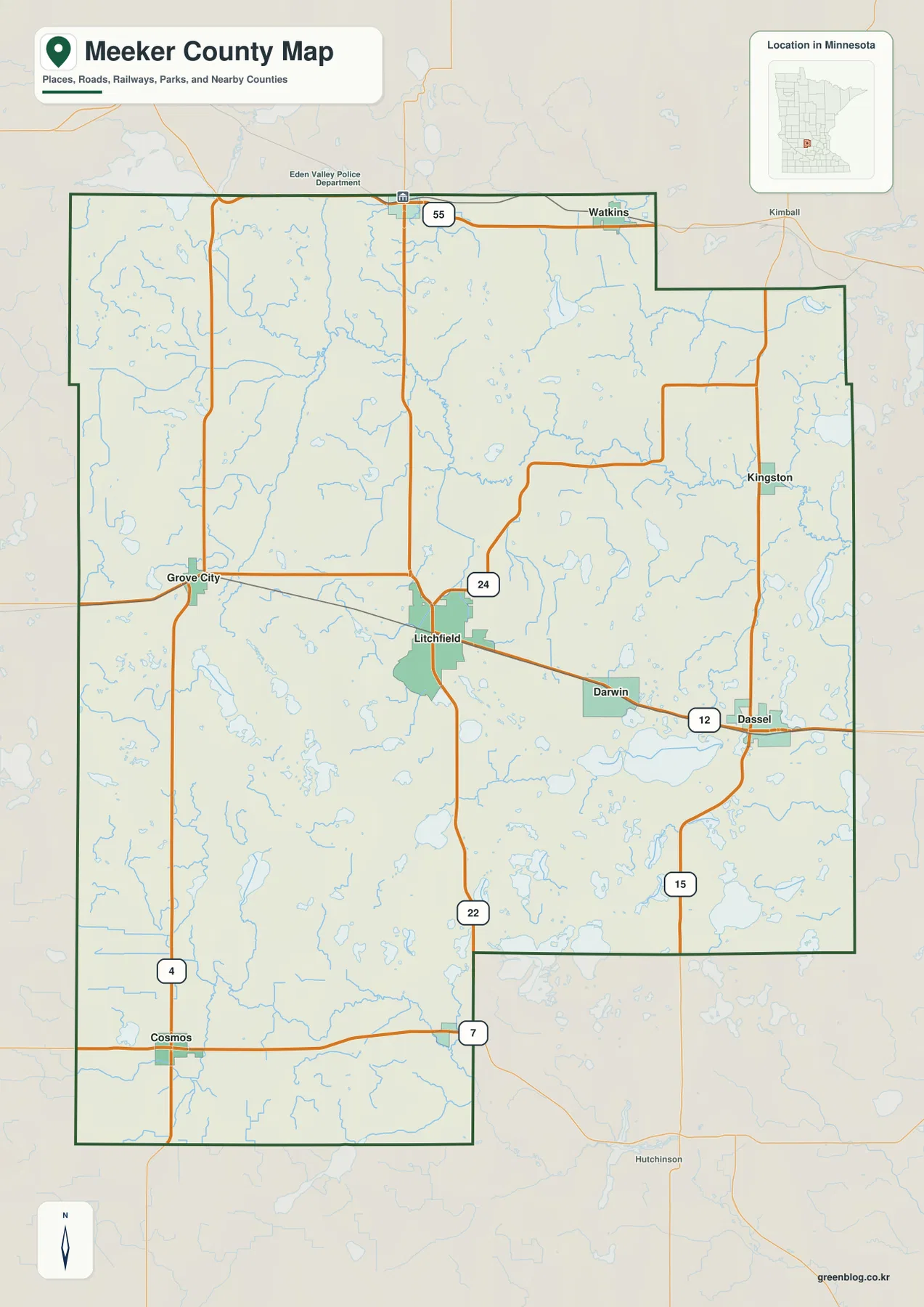
The boundary itself has several steps and indentations, especially on the east and south sides, so it is useful to follow the dark county outline rather than assuming a simple rectangle. The map is intended for geographic orientation, road context, and town location. It should not be used as a parcel, zoning, survey, or legal-boundary map when property-level accuracy is required.
Six Major Communities from Eden Valley to Cosmos
The city distribution map highlights six major communities and provides a ranked index. The index lists Litchfield at 6,576, Dassel at 1,358, Eden Valley at 1,002, Grove City at 814, Watkins at 765, and Cosmos at 536. Those figures are useful for understanding the relative scale shown by this particular map; anyone who needs the latest official population estimate should check current Census data rather than treating the map index as a live demographic table.
Location is as important as rank. Litchfield sits near the middle of the highlighted group, Dassel is well to the east, and Grove City is to the west. Eden Valley and Watkins are both near the northern edge, while Cosmos is separated from the other major communities in the southwest. The result is a dispersed settlement pattern rather than a single chain of towns packed along one highway.
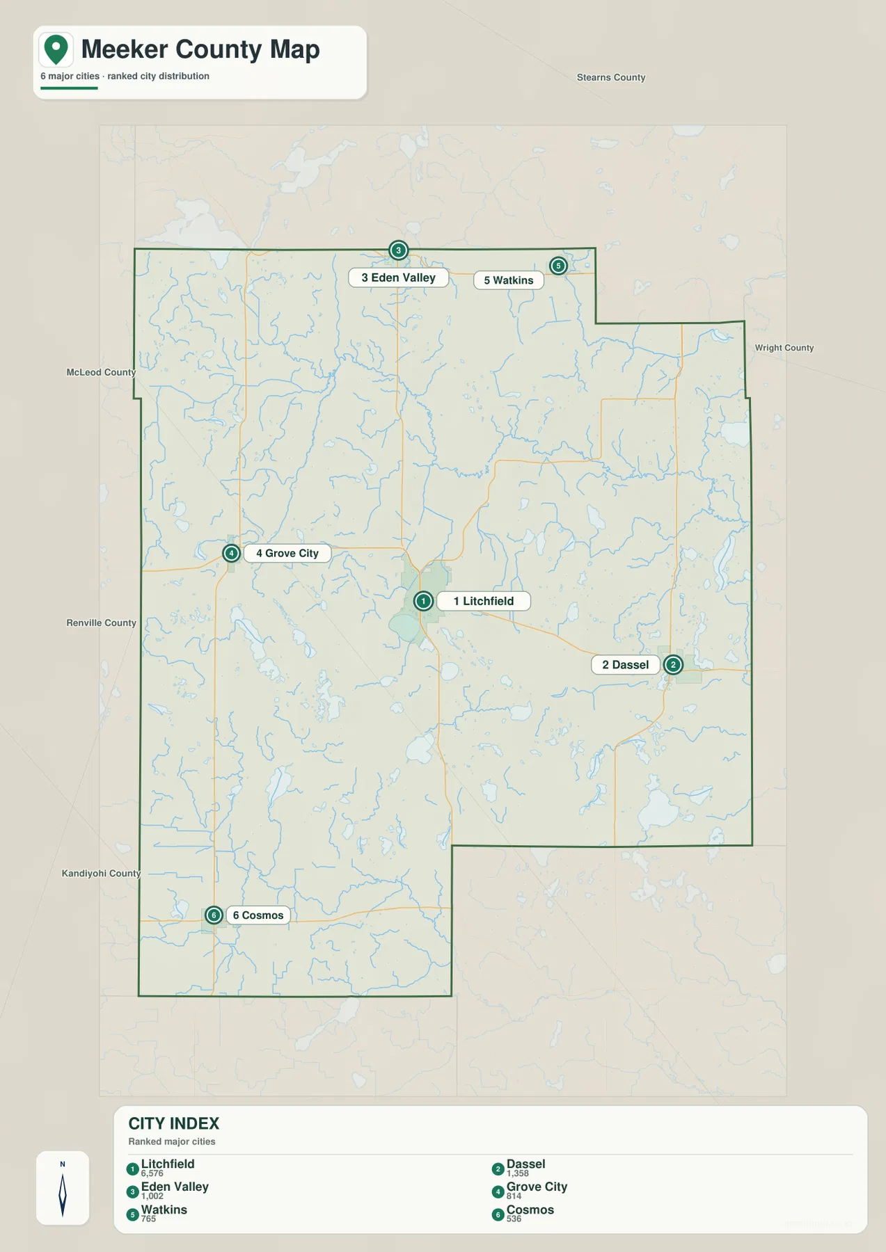
The map also shows surrounding counties: Stearns County to the north, Wright County to the east, and McLeod, Renville, and Kandiyohi counties along the western and southwestern sides. That surrounding context makes it easier to see which Meeker County towns are closest to different county boundaries. The city map is a simplified comparison of major population centers, not a complete municipal or road directory.
Lake Koronis and the Three Crow River Forks
Meeker County’s water map is organized around several branches of the Crow River rather than one dominant channel. The Middle Fork Crow River enters the northwestern part of the map near Lake Koronis and bends toward the center. The North Fork Crow River crosses the eastern half in a long, winding path, while the South Fork Crow River appears separately in the southwest. Together they create a water network that reaches very different parts of the county.
Named lakes are distributed just as widely. Lake Koronis is in the northwest, Long Lake is farther south on the western side, and Big Swan Lake plus Washington Lake appear in the east. Cedar Lake, Belle Lake, and Lake Jennie form another group toward the southeast. Grove Creek, Clearwater River, and Washington Creek add smaller connections that are easy to miss on a road-focused map.
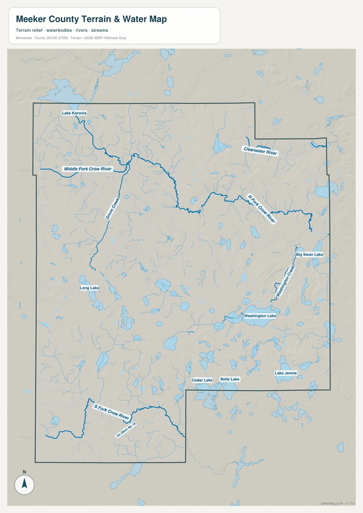
In the south, the South Fork Crow River and County Ditch No. 13 stand out against a landscape filled with smaller water features. The eastern half also contains many small lakes and tributaries around the North Fork Crow River. This map is useful for geographic reference, but it is not a floodplain, depth, navigation, public-access, or property-boundary product. Current recreation and access questions should be checked with Minnesota DNR or the appropriate local authority.
Higher Western Ground and Lower Terrain to the East
The elevation map shows one of the clearest geographic contrasts in Meeker County: the west and northwest are generally higher than the east. Its legend gives an actual elevation range of about 306 to 383 meters and a mean near 342 meters. Broad brown and orange areas cover much of the western side, while green tones dominate large parts of the east, making the west-to-east drop visible at a glance.
Higher ridges also appear across parts of the north-central and northeastern area, separated by lower corridors. The eastern side is lower overall but still contains small hills and depressions rather than one flat surface. When compared with the water map, the lower eastern terrain helps give context to the winding North Fork Crow River and the many lakes and tributaries found in that part of the county.
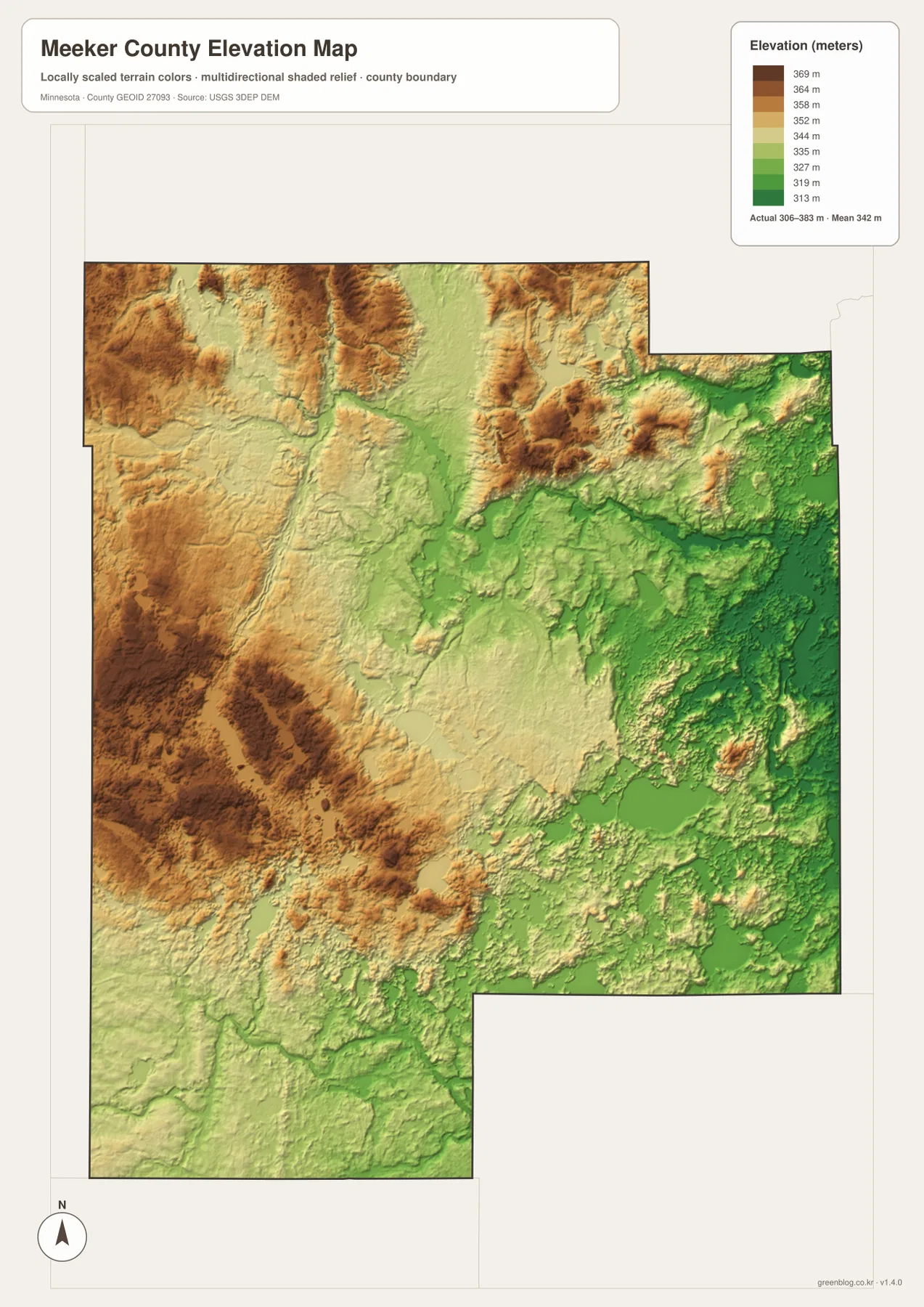
The color scale is locally adjusted to make differences within Meeker County visible. A brown area here should not be compared directly with a brown area on another county map as though both represented the same absolute elevation. The shaded relief is also a generalized visual surface, not survey-grade information. Engineering, drainage, construction, or legal elevation work requires more precise site-specific data.
Choosing a Map for Roads, Water, or Relief
For roads and general orientation, the county overview is the strongest first choice. It shows how U.S. 12 links Litchfield, Darwin, and Dassel, how Minnesota 55 serves the northern edge, and how the southern and western roads reach Cosmos and Grove City. When the main question is simply where the six highlighted communities sit relative to one another, the city distribution map removes much of the road detail and makes that comparison faster.
The water map becomes more useful when a place name is tied to a lake or river rather than a highway. Lake Koronis, the three Crow River forks, Big Swan Lake, Washington Lake, and the southeastern lake group are much easier to distinguish there. The elevation map answers a different question by showing why western Meeker County looks higher and why so much of the eastern half falls into lower green terrain.
The WebP maps on the page are optimized for convenient viewing. The downloadable ZIP contains four corresponding high-resolution JPG originals, each 2572 by 3638 pixels. Those files are better suited to printing or close inspection of smaller labels than a browser screenshot, especially when the goal is to zoom into a creek name, a small town, or a road number without losing as much detail.
Using the maps together reveals relationships that a single layer can hide. A reader can trace U.S. 12 from Litchfield to Dassel on the county map, compare nearby lakes and the North Fork Crow River on the water map, and then see how the eastern landscape sits lower on the elevation map. The same approach works in the west, where Grove City and the higher western terrain can be compared with the Middle and South Fork areas of the Crow River.
Frequently Asked Questions
Which Meeker County map is best for finding Litchfield and Dassel?
Use the county overview first. Litchfield appears near the center-south of the county and Dassel is to the east, with U.S. 12 connecting the two areas through Darwin. The city distribution map is useful as a second view when you want to compare them with Eden Valley, Grove City, Watkins, and Cosmos without as much road detail.
How are the Crow River branches arranged in Meeker County?
The water map shows three separate branches in different parts of the county. The Middle Fork Crow River is in the northwest near Lake Koronis, the North Fork Crow River winds across the eastern half, and the South Fork Crow River crosses the southwest. Looking at the three branches separately is more accurate than imagining one continuous river line through the county.
What does the elevation map say about western and eastern Meeker County?
The western and northwestern areas are generally higher, while much of the east is lower. The legend shows an actual range of roughly 306–383 meters with a mean near 342 meters. The colors are scaled to highlight local differences, so they are useful for broad geographic comparison but not for survey, construction, or engineering decisions.
Map File Information
The ZIP contains the original high-resolution JPG versions of the Meeker County overview, city distribution, water, and elevation maps.
- File Type: ZIP containing 4 JPG files
Related Maps
Sources and References
- Meeker County official website – county government and local information
- U.S. Census Bureau TIGER/Line Shapefiles – county boundaries and geographic reference data
- USGS National Hydrography – river, stream, and lake reference data
- USGS 3D Elevation Program – elevation reference data
Green Map creates custom-edited map images using open geographic data sources such as geoBoundaries, Natural Earth, OpenStreetMap, and government open data. These maps are edited visual materials, not raw data files, and are provided for education, documents, presentations, and graphic reference.