Lac qui Parle County lies in western Minnesota, with Madison near the center, Dawson farther east, and several small communities scattered toward the South Dakota line. Yellow Bank River and Lac qui Parle River cross a landscape that rises toward the west and southwest and drops toward the Minnesota River side of the county. The road map looks broadly agricultural, but the water and elevation views reveal a clear contrast between uplands and lower river valleys.
This page uses the supplied county, city, water, and elevation maps to explain those local relationships with the actual roads, communities, rivers, lakes, and relief shown in the package. Original high-resolution JPG versions are also available together in one ZIP download for printing, classroom work, presentations, or image editing.
Table of Contents
Madison and Dawson define the county’s central road pattern
Madison is the easiest starting point on the general county map. Highway 75 runs north-south near the city, while Routes 40 and 20 extend toward the western boundary. The Lac qui Parle County Courthouse is also marked in the Madison area, reinforcing the city’s role as the county’s administrative reference.
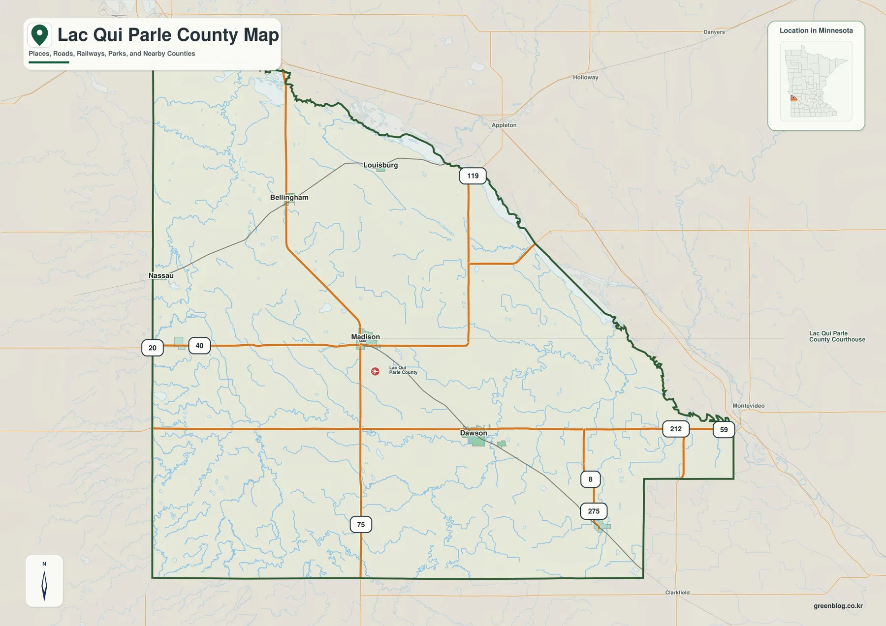
Dawson forms the second major road reference farther east and south. Highway 212 continues toward Montevideo, while Highway 59 runs north-south near the eastern side. Routes 8 and 275 are visible farther southeast, making the Dawson area the clearest transition between the county interior and communities beyond the eastern boundary.
Bellingham and Louisburg provide northern and northwestern references. Highway 119 passes near Louisburg and continues toward the northeastern boundary, while Bellingham sits inland between the South Dakota side and Madison. Nassau lies directly along the western county edge, giving it a very different geographic setting from Madison or Dawson.
The county boundary slopes southeastward across the north and east before stepping around the southeastern corner. Montevideo is labeled outside the east, and Appleton appears beyond the northeast, helping place Lac qui Parle County on the western side of the broader Minnesota River region. The map is intended for orientation rather than live traffic conditions or construction updates.
Madison, Dawson, and four smaller western communities
The city map highlights Madison, Dawson, Boyd, Marietta, Bellingham, and Nassau. Madison sits near the county center, Dawson is farther southeast, Boyd is near the lower eastern interior, and Marietta and Nassau are close to the western border. Bellingham occupies the northwest, giving the selected communities a broad county-wide spread.
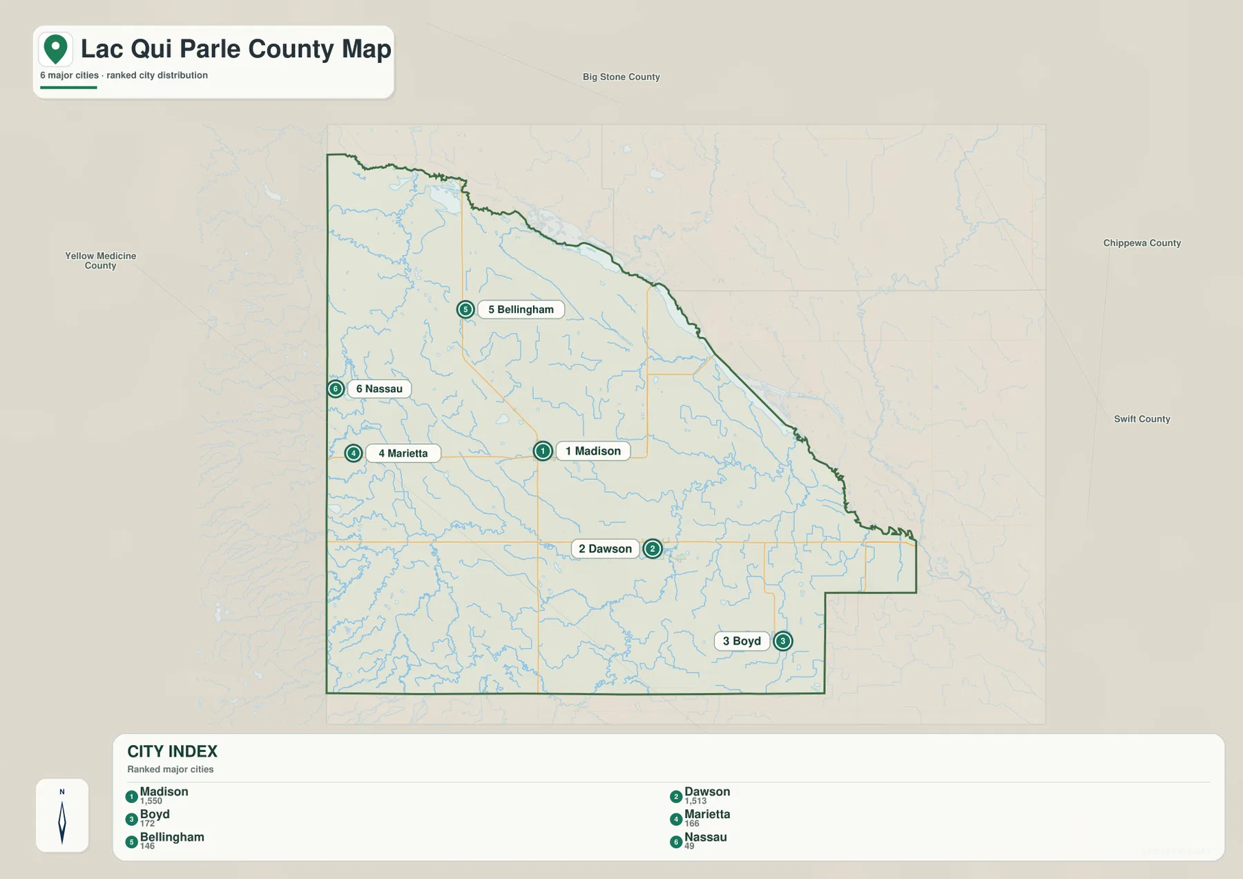
The CITY INDEX printed on the supplied map lists Madison at 1,550, Dawson at 1,513, Boyd at 172, Marietta at 166, Bellingham at 146, and Nassau at 49. These values should be treated as index figures embedded in the map rather than as the latest official population estimates. Their main value is comparative: Madison and Dawson are represented at nearly the same scale and far above the other four selected communities.
Madison and Dawson are similar in index size but occupy different parts of the county. Madison is tied to Highway 75 and the central road network, while Dawson is closer to Highway 212 and the lower eastern river country. Marietta and Nassau sit near the South Dakota side, Boyd anchors the southeast, and Bellingham gives the northwest a separate small-town reference.
This city view is not a driving-distance map. Actual travel between Madison and Dawson or between the western border towns and the eastern side depends on the road chosen. Use the city map for relative position, then return to the general county map when route numbers and road connections matter.
Yellow Bank River and the northwest tributaries
Yellow Bank River is one of the strongest named waterways in the northwest. South Fork Yellow Bank River and another labeled South Fork branch approach from the west before joining the broader system. The multiple branches create a network of low corridors through otherwise open agricultural terrain.
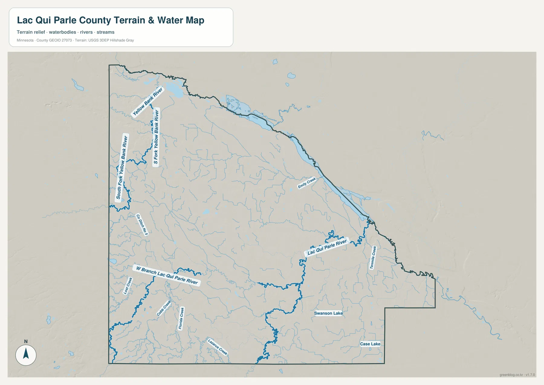
Small lakes and wet areas are scattered near the northwestern edge, while short tributaries repeatedly enter the Yellow Bank system. This part of the county looks much more water-rich on the hydrography view than it does on the road map, even though there is no single large lake dominating the interior.
The map also labels drainage features such as Co Branch 5 near the west. These straighter channels are visually distinct from the winding natural rivers and are useful for understanding how water is managed across flat agricultural land. Legal drainage responsibilities and exact ditch boundaries, however, should be checked with county records rather than inferred from this overview.
Lac qui Parle River descends toward the eastern valley
Lac qui Parle River crosses the south-central and eastern parts of the county and is the most important waterway sharing the county’s name. West Branch Lac qui Parle River approaches from the southwest, while the main channel bends east of Dawson toward the Minnesota River valley. The river corridor becomes increasingly low on the elevation map as it approaches the county’s eastern side.
Emily Creek and Tenmile Creek are labeled in the east, while Lazarus Creek, Fiddle Creek, and Cobb Creek appear farther south and west. These smaller channels follow different local routes but generally fit the wider pattern of drainage moving away from higher western and southwestern ground toward lower eastern valleys.
Swanson Lake and Case Lake are labeled in the southeastern half. Lac qui Parle Lake itself lies mostly farther east along the Minnesota River corridor, where Minnesota DNR manages Lac qui Parle State Park and the large Lac qui Parle Wildlife Management Area. Those official resources provide better detail for recreation and habitat questions around the larger lake system.
This water map is intended for geographic orientation, not for flood-hazard, navigation, parcel, or water-depth decisions. County records, Minnesota DNR, and federal water data should be used when those details matter.
A 282–429 meter range from southwest uplands to northeastern lowlands
The supplied elevation map reports an actual range of about 282 to 429 meters, with a mean near 325 meters. The highest brown terrain occupies the southwest and western side, while green lower terrain expands toward the north and east. The northeastern boundary and eastern river valleys are especially low compared with the southwest uplands.
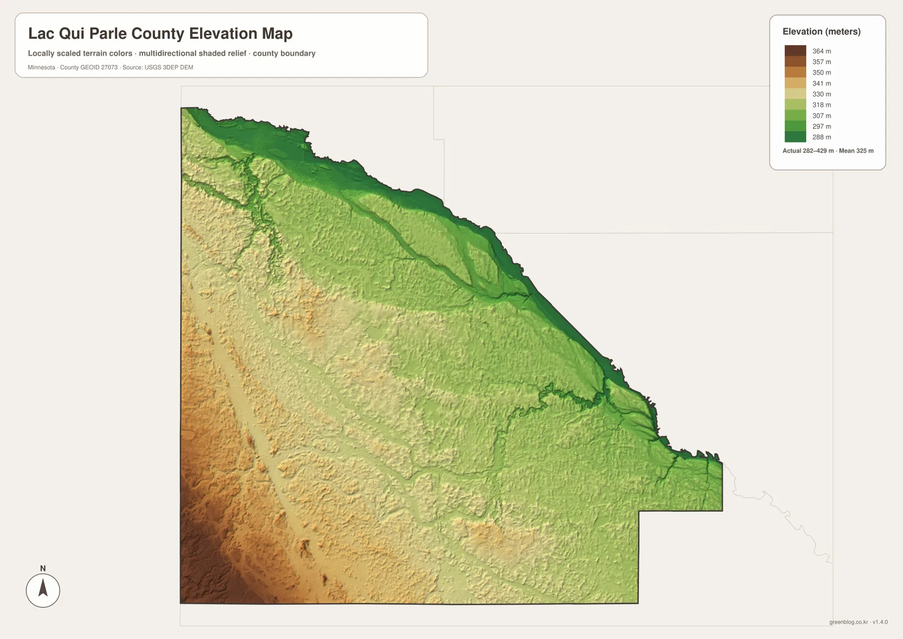
The southwest contains the strongest tan and brown relief in the county. West Branch Lac qui Parle River and smaller tributaries cut lower corridors through that elevated landscape, and the ground gradually drops toward Madison and the central interior. Marietta and Nassau are closer to this higher side than Dawson.
Yellow Bank River creates another clear low corridor in the northwest. Its branches are easy to match between the water and elevation views because green strips follow the channels across otherwise higher farmland. Farther northeast, broad low terrain becomes more dominant near the sloping county boundary.
The east and southeast are lower overall but still contain gentle hills. Lac qui Parle River occupies a distinct lower route around the Dawson side and continues toward the Minnesota River valley. The broad county pattern therefore runs from higher southwest and west toward lower northeast and east, with river valleys adding narrower low features throughout.
This elevation surface is useful for county-scale comparison, not surveying or engineering. It should not be used for exact building elevations, road grades, drainage design, or parcel-level contour decisions. Detailed USGS 3D Elevation Program products or professional survey data are the better sources when precision matters.
Madison and Dawson occupy different parts of the relief
Madison lies near the middle of the county where the high western side begins to step down toward the east. Highway 75 and Route 40 make it a strong transportation reference, while nearby small streams connect to the wider Yellow Bank and Lac qui Parle drainage systems. On the elevation view, Madison sits between the strongest southwest uplands and the lower Dawson side.
Dawson is more closely tied to the lower Lac qui Parle River corridor. Highway 212 continues toward Montevideo, and the terrain becomes greener as the river approaches the Minnesota River valley. The two major cities are similar in map index size, but their surrounding waterways and relief are noticeably different.
Marietta and Nassau sit closer to the higher South Dakota side, while Bellingham lies in the northwest near the Yellow Bank drainage. Boyd occupies the southeastern interior closer to lower river terrain. Comparing these communities across the city and elevation views makes the county’s west-east physical contrast much easier to see.
Choosing a map for roads, towns, rivers, or relief
Use the general county map when Madison, Dawson, Bellingham, Marietta, Nassau, and the major numbered roads need to appear together. The city map is cleaner when the goal is to compare the six selected communities and their map index values without the full road network.
The water map is the stronger choice for Yellow Bank River, Lac qui Parle River, their branches, and the county’s smaller lakes and creeks. Pair it with the elevation map when the goal is to explain why the southwest is higher and why the eastern river valleys sit lower.
For printing or image editing, the original JPG files in the ZIP provide more resolution than the WebP previews embedded in this article. Each JPG measures 3638 by 2572 pixels, and the archive contains the county, city, water, and elevation maps.
Official county, DNR, and federal references
Lac qui Parle County’s official website lists the County Courthouse at 600 6th Street in Madison and provides county departments, property-tax, land, and resident services. Parcel, permit, tax, and official road questions should rely on those current county resources rather than on a general overview map.
The county’s official history page explains the origin of the Lac qui Parle name, while Minnesota DNR provides current information for Lac qui Parle State Park and the wildlife management area. USGS National Hydrography supports river and stream data, and the USGS 3D Elevation Program provides detailed elevation products.
Frequently Asked Questions
Are Madison and Dawson similar in size on the supplied map?
Yes. The CITY INDEX shows Madison at 1,550 and Dawson at 1,513, so the two selected communities are represented at nearly the same scale. Those are map index values, not a statement of the latest official population estimates.
Where does Lac qui Parle River run?
The water map shows Lac qui Parle River crossing the south-central and eastern county near the Dawson side before continuing toward the Minnesota River valley. West Branch Lac qui Parle River approaches from the southwest.
Where is the highest terrain in Lac qui Parle County?
The supplied elevation map shows a range of about 282–429 meters with a mean near 325 meters. The west and southwest are highest overall, while the northeastern boundary and eastern river valleys are lower. Exact site elevations require detailed USGS or survey data.
Map File Information
Download the original high-resolution JPG versions of the Lac qui Parle County maps shown on this page in one ZIP file.
- Included Files: county map, city map, water map, elevation map
- Printable Size: each JPG is 3638 × 2572 px
- File Type: ZIP containing 4 JPG files
Related Maps
Sources and references
- Lac qui Parle County official website – county government and Madison courthouse information
- Lac qui Parle County Our History – county name and local history
- Minnesota DNR Lac qui Parle State Park – lake and Minnesota River valley reference
- Minnesota DNR Lac qui Parle WMA – wildlife management area information
- USGS National Hydrography – river, stream, and water data
- USGS 3D Elevation Program – elevation data and products
Green Map creates custom-edited map images using open geographic data sources such as geoBoundaries, Natural Earth, OpenStreetMap, and government open data. These maps are edited visual materials, not raw data files, and are provided for education, documents, presentations, and graphic reference.