Oceana County occupies a distinctive strip of western Michigan where Lake Michigan, coastal lakes, inland towns, river valleys, and higher ridges sit within a relatively compact area. Pentwater is tucked into the northwestern waterfront, while Hart, Shelby, New Era, and Rothbury form a more inland chain near US-31. Hesperia and Walkerville lie farther east, giving the county a clear contrast between the western highway corridor and smaller communities away from the lakeshore. The maps used on this page are also available as high-resolution A3 JPG files in a single ZIP archive. High-resolution map files are available for download in the section below.
The physical setting changes just as noticeably as the settlement pattern. The Pentwater River system drains the northwestern part of the county toward Pentwater Lake and Lake Michigan, while branches of the White River cross the south and east. Silver Lake, Stony Lake, Hart Lake, Campbell Lake, and Lake Oceana add smaller bodies of water to that network. Elevation rises away from the shoreline and major valleys, with the strongest uplands appearing through the center and northeastern interior. Reading those layers together gives a much more accurate sense of Oceana County than treating it as a uniformly flat lakeshore county.
Table of Contents
A chain of west-side communities follows US-31 without hugging the shoreline
The general county map makes the western pattern immediately visible. Pentwater sits at the northwestern edge beside Pentwater Lake and close to Lake Michigan. Hart and Mears are farther south and inland, followed by Shelby, New Era, and Rothbury. Several of those places lie near US-31, so the highway provides a simple north-south reference through the county’s more populated western side. The road does not run directly along the beach; it stays inland while the shoreline bends west of the communities and coastal lakes.
The eastern half is much less linear. Walkerville appears well inside the northeastern part of the county, while Hesperia lies near the eastern boundary in the south. That separation matters because a quick glance at the US-31 corridor can otherwise make Oceana County look more concentrated than it really is. The basic map and the city index emphasize different places as well: Walkerville is labeled on the general map, whereas Hesperia is one of the six communities highlighted in the ranked city view. Comparing the two avoids the assumption that either map is intended to be a complete list of every settlement.
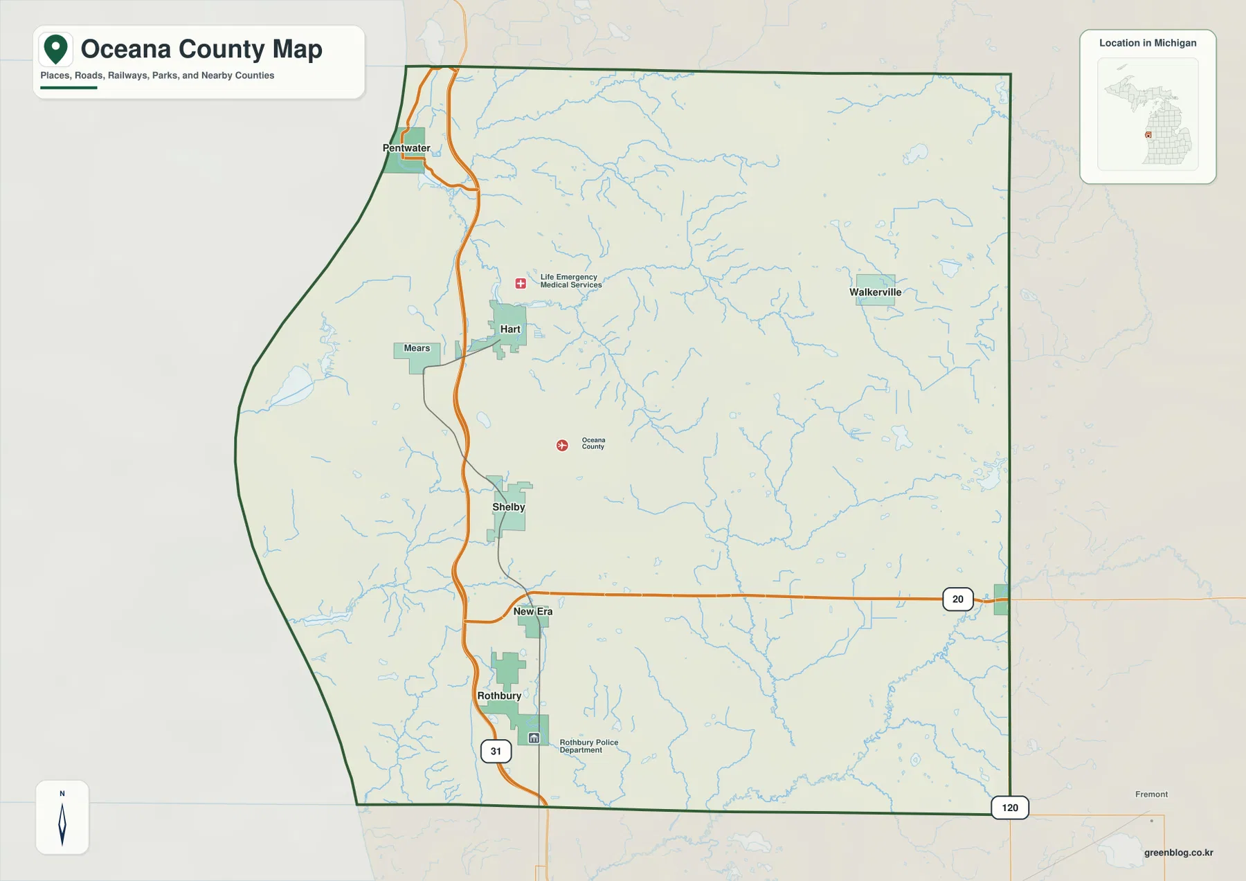
Two numbered routes are especially helpful for orientation. US-31 runs north and south near Rothbury, New Era, Shelby, and Hart before continuing toward the Pentwater area and Mason County. M-20 crosses the southern part of Oceana County from the New Era vicinity toward Hesperia and the eastern boundary. These roads establish the large-scale framework, but they do not replace current navigation. Lakes, river crossings, local roads, construction, and seasonal changes can make an actual trip longer or more complicated than the county-scale map suggests.
Shelby and Hart anchor the city index, while Pentwater and Hesperia sit apart
The city index strips away much of the background detail and ranks six selected communities: Shelby first, Hart second, Hesperia third, Pentwater fourth, New Era fifth, and Rothbury sixth. Its value is not the ranking alone. The simplified layout makes the county’s settlement geography easier to compare. Shelby and Hart sit close to one another in the western interior, New Era and Rothbury extend the same general corridor southward, Pentwater is isolated toward the Lake Michigan corner, and Hesperia is separated from the group at the eastern edge.
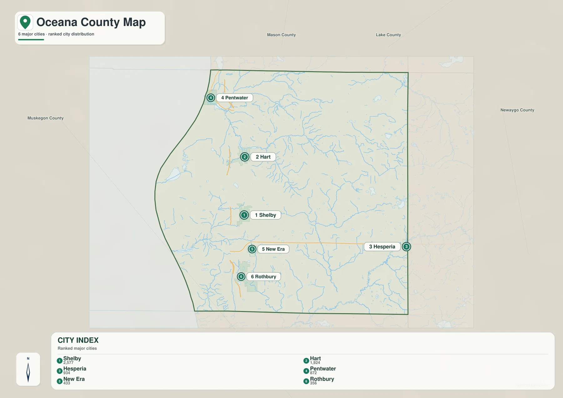
Hart is the county seat and occupies a central position within that west-side group, while Shelby lies farther south. New Era and Rothbury continue toward the southern boundary near US-31. Pentwater’s setting is very different because it is associated with a lake harbor and the Lake Michigan shore rather than the highway corridor itself. Hesperia, meanwhile, sits on the far eastern side of the county and is reached from the west by routes that cross the interior rather than simply following US-31. Those distinctions are useful in a presentation or classroom map because they explain the county through a few recognizable locations instead of a long list of road names.
The index should still be read as a selected comparison rather than a definitive inventory. Walkerville is a good example: it appears on the general county map in the northeast but is not one of the six indexed places. The two map types therefore answer different questions. One shows how towns, roads, streams, and boundaries fit together; the other reduces the visual noise so the spacing among a small group of communities stands out. Using both is more informative than treating the simplified index as a substitute for the full county map.
Pentwater and White river networks drain different parts of the county
The terrain-and-water map separates the northern Pentwater system from the White River branches farther south. North Branch Pentwater River comes in from the north and east, while South Branch Pentwater River crosses the interior before joining the lower river. The water then reaches Pentwater Lake beside the village of Pentwater and continues toward Lake Michigan. Hart Lake lies inland near the same broader drainage area, linking the town of Hart to the county’s northern river geography rather than to the White River system.
Farther south, North Branch White River and South Branch White River form a separate network across the eastern and southern parts of Oceana County. The main White River follows the lower edge of the map near the county line. Several lakes sit outside those principal channels: Silver Lake and Stony Lake are close to the Lake Michigan side, Lake Oceana is in the southwestern interior, and Campbell Lake lies well to the east. Their positions show why a simple “coastal versus inland” division is not enough; water is distributed through several distinct basins and isolated lakes.
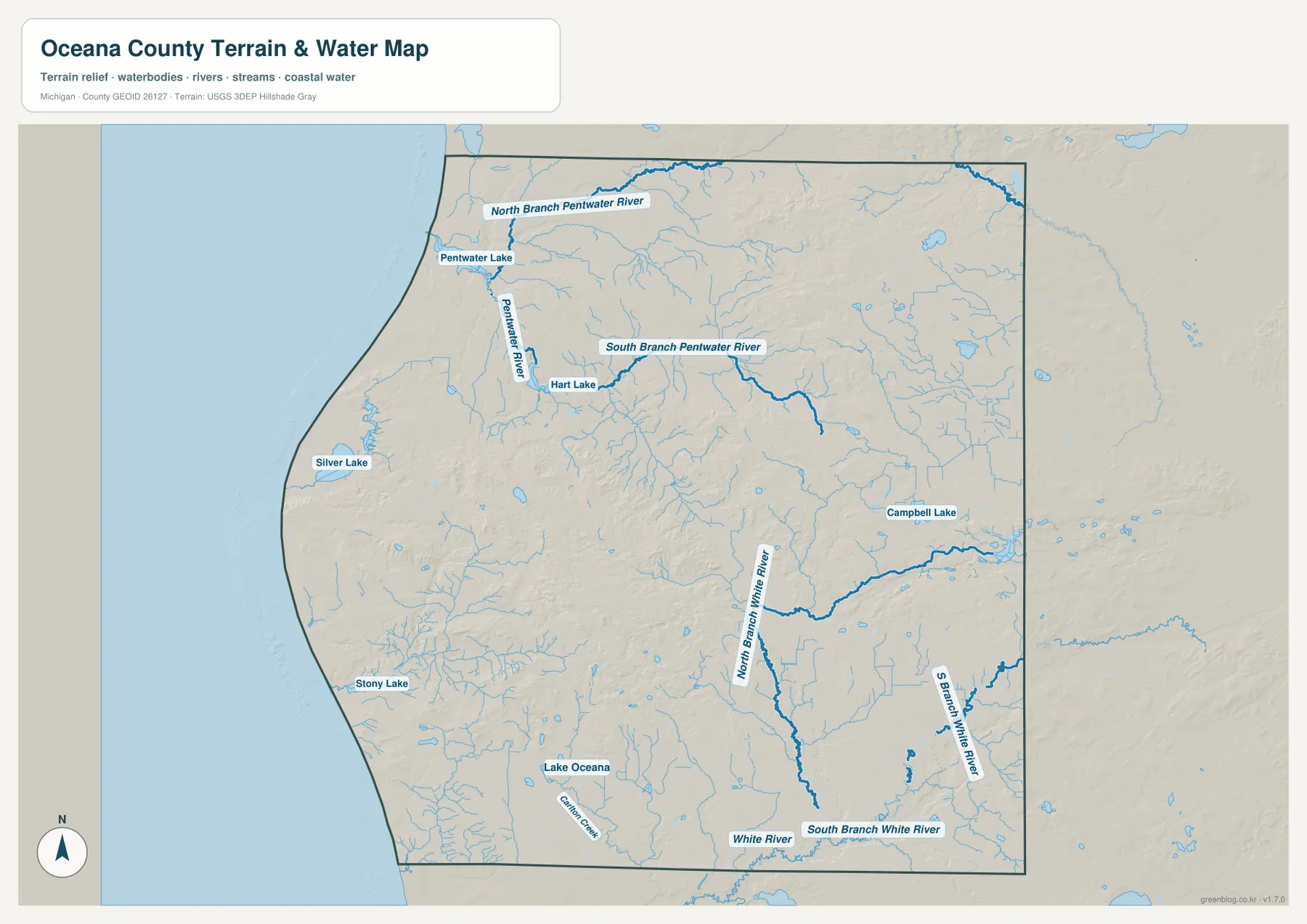
This map is intended for geographic reference rather than water-use decisions. It does not provide flood elevations, channel depth, current flow, navigability, boat-launch status, or legal access. Those questions require current information from the responsible agencies. For county geography, however, the map clearly shows which named streams belong to the Pentwater or White River systems and where the larger lakes sit relative to the communities and highways.
Interior ridges rise well above the lakeshore and major stream valleys
The elevation map records an actual range of about 176 to 329 meters, with a mean near 231 meters. Low green terrain dominates much of the Lake Michigan side, but large brown uplands occupy the center of the county and another high area spreads across the northeast. These are not minor color changes. The shaded relief shows steep local transitions around some of the central ridges, while lower corridors extend through them along stream valleys.
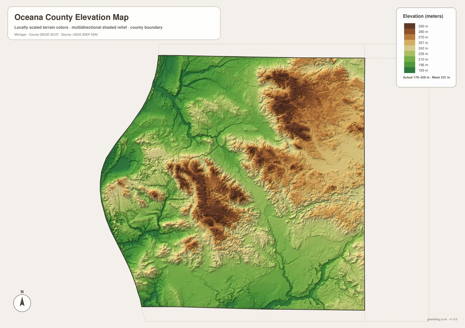
The river network fits that relief. Lower green channels cut between the higher interior areas, especially where tributaries feed the Pentwater and White river systems. The western shore is generally lower, yet the Silver Lake area is not featureless: dune terrain and nearby hills create visible relief close to Lake Michigan. At county scale, that combination of low coastal land, incised valleys, and higher interior ridges is one of the strongest geographic signatures in the map set.
The elevation colors are useful for regional comparison but should not be treated as a parcel-level survey. Exact elevations for construction, drainage design, engineering, or property work should come from original USGS data and site-specific surveying. For a school project or county overview, the shaded relief provides enough context to explain why river valleys appear as lower corridors and why the interior does not resemble the flatter shoreline zone.
Silver Lake and Pentwater give the western shore two different landscapes
Silver Lake is one of the clearest places where water, dunes, and relief meet. Michigan’s Department of Natural Resources describes Silver Lake State Park as including Lake Michigan shoreline, a large dune area, and the inland waters of Silver Lake. On the county map, the lake lies south of Pentwater and west of the main US-31 corridor. The water view isolates the lake from the Pentwater River system, while the elevation view reveals the uneven ground around the coastal zone. Together those details explain why the Silver Lake area looks physically different from the lower river valleys farther east.
Pentwater has a different waterfront arrangement. The community sits beside Pentwater Lake near the outlet of the Pentwater River system, with Lake Michigan immediately to the west. Hart is only a short distance inland but lacks that same harbor-and-river setting. This difference matters when planning a regional overview: Pentwater is best understood through its relationship with water, while Hart and Shelby fit more naturally into the US-31 inland corridor. A static county map can establish those relationships, but current marina rules, park hours, road work, and seasonal access should be checked separately before a visit.
The county government describes Oceana County as part of West Michigan’s agricultural and recreational heartland. The maps do not identify individual farms, land ownership, or detailed recreation facilities, so they should not be stretched beyond what they actually show. What they do show very well is proximity: coastal recreation around Silver Lake and Pentwater sits surprisingly close to the inland communities and the US-31 corridor. That short geographic distance helps explain how lakeshore tourism and inland daily life coexist within the same county.
Using the A3 JPG files for print, classwork, and local reference
The downloadable archive contains the original JPG versions corresponding to the county map, city index, terrain-and-water map, and elevation map on this page. Each image is 3638 × 2572 pixels and prepared for A3 landscape printing. The general map is the strongest choice for a broad county overview, the city index works well when place names need to stay readable on a slide, the water map is better for river and lake discussions, and the elevation image gives the clearest view of shore-to-interior relief.
Before printing, check the page margins and scaling so smaller stream or place labels remain legible. These are general reference maps, not legal boundary surveys, parcel maps, emergency-response products, flood maps, or engineering drawings. Any decision that depends on exact coordinates, ownership, current road conditions, flood status, or precise elevation should use the responsible agency’s current data rather than the downloadable images alone.
Frequently Asked Questions
Which view is best for comparing Pentwater with Hart and Shelby?
Use the general county map when roads and water need to be visible at the same time. Pentwater is in the northwestern waterfront area, while Hart and Shelby are farther inland near US-31. New Era and Rothbury continue south along the same broad corridor. The city index is cleaner for comparing only the selected communities, but current navigation is still needed for driving distance and travel time.
Where are Silver Lake and the Pentwater and White river branches easiest to see?
The terrain-and-water map is the clearest source. It labels Pentwater Lake, Silver Lake, Stony Lake, Hart Lake, Campbell Lake, Lake Oceana, the North and South branches of the Pentwater River, and major White River branches. It is designed to show geographic location and connection, not flood level, water depth, boating conditions, or access rules, so those details should be checked with current agency information.
Where is the highest terrain in Oceana County?
The elevation map places the most prominent high ground in the central and northeastern interior. The legend spans roughly 176 to 329 meters, and the highest areas appear in brown above the lower green shorelands and river valleys. The map is suitable for county-scale comparison, while exact site elevations require original elevation data or surveying.
Map File Information
Download the high-resolution JPG versions of the Oceana County maps used on this page in one ZIP archive.
- Included Files: county map, city map, water map, and elevation map
- File Type: ZIP containing 4 JPG files
Related Maps
Sources and references
- Oceana County official website — county government and regional background
- Michigan DNR – Silver Lake State Park — Silver Lake, Lake Michigan shoreline, dunes, and park information
- U.S. Census Bureau – TIGER/Line Shapefiles — county boundaries and general geographic reference
- U.S. Geological Survey – National Hydrography — rivers, streams, and lakes
- U.S. Geological Survey – 3D Elevation Program — elevation and terrain reference
Green Map creates custom-edited map images using open geographic data sources such as geoBoundaries, Natural Earth, OpenStreetMap, and government open data. These maps are edited visual materials, not raw data files, and are provided for education, documents, presentations, and graphic reference.