Taylor County occupies Iowa’s southern border with Missouri, and its towns are spread across a landscape of rolling uplands and narrow stream valleys. This Taylor County Iowa map set brings together the county boundary and road network, a simplified city distribution map, waterways and terrain, and a color-scaled elevation map. The article images are lightweight previews for quick viewing, while the same four maps are available below as full-resolution JPG files in a single downloadable ZIP.
Bedford is the easiest place to begin. It is the county seat and sits in the southern half of the county along Iowa Highway 2. Lenox anchors the north, New Market lies near the western side, Clearfield sits near the east, and Gravity and Blockton fill out the west-central and southeastern portions of the map. The water map adds the branches of the One Hundred and Two River, the East Nodaway River, Lake of Three Fires, and several smaller lakes. On the elevation image, those waterways align with lower green valleys cut into higher rolling ground, making the four maps useful as a connected geographic set rather than four unrelated pictures.
Table of Contents
Using Bedford and Highway 2 as the first orientation points
The county reference map is the best starting point because it combines towns, major roads, streams, and the county outline in one view. Bedford appears in the southern half of Taylor County, and Highway 2 runs east-west through the city before continuing toward the eastern boundary. Highway 148 heads south and southwest from the Bedford area, while Highway 25 provides a north-south reference on the eastern side. Those numbered routes make it much easier to place the smaller towns and local roads than it would be on an outline-only county map.
Lenox stands near the northern edge and is visually separate from the Bedford area. Sharpsburg and Conway sit farther south, with Gravity toward the west-central portion of the county. New Market is close to the western boundary, Clearfield lies near the eastern boundary, and Blockton and Athelstan mark the southeast and southern edge. The pattern is dispersed rather than concentrated around one urban center. That spacing is important when reading the map because a place described as “near Taylor County” may still be a considerable distance from Bedford depending on which corner of the county it occupies.
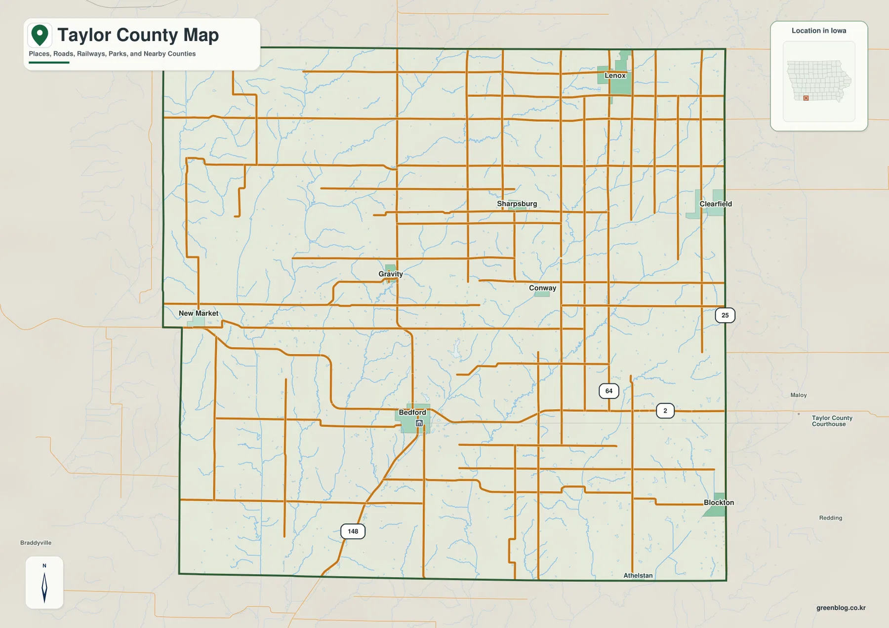
The surrounding context also helps explain where Taylor County sits within Iowa. The county’s official hazard mitigation plan describes it as part of the southernmost tier of Iowa counties, with Missouri on the south, Page County to the west, Ringgold County to the east, and Adams County to the north. The outline looks almost rectangular at first glance, although the western side contains an inward step that makes the boundary less regular. For a quick regional explanation, this map works well because the local road network remains visible without losing the county edge.
Highway 2 is especially useful as a visual divider across the southern half. Once Bedford is found on that route, the position of Highway 25 to the east and Highway 148 to the southwest gives the reader a simple framework for the rest of the road network. The numerous thinner roads fill the agricultural countryside between towns, but they are easier to interpret after the major routes have been identified. This is not a live navigation map and it does not show traffic conditions or road closures; its purpose is county-scale geographic reference.
A six-city pattern stretching from Lenox to Blockton
The city distribution map removes much of the road detail and highlights six communities: Lenox, Bedford, New Market, Clearfield, Gravity, and Blockton. The printed index places Lenox first and Bedford second, followed by New Market and Clearfield, with Gravity and Blockton completing the group. Because only the principal cities are emphasized, the spacing between them is easier to compare than on the full county map. The result is a clear north-to-south and west-to-east pattern rather than a single cluster of towns around the county seat.
Bedford remains the administrative reference point. Taylor County’s official website lists the courthouse in Bedford, so a reader looking for county government can immediately connect the city name with the center of county administration. Lenox, however, is farther north and appears as the largest city in this particular map index. New Market and Clearfield serve as useful opposite-side markers near the west and east, while Gravity sits inland from the west and Blockton marks the southeastern part of the county. That distribution gives the map a practical value even without detailed road labels: it answers the basic question of which town is in which part of Taylor County.
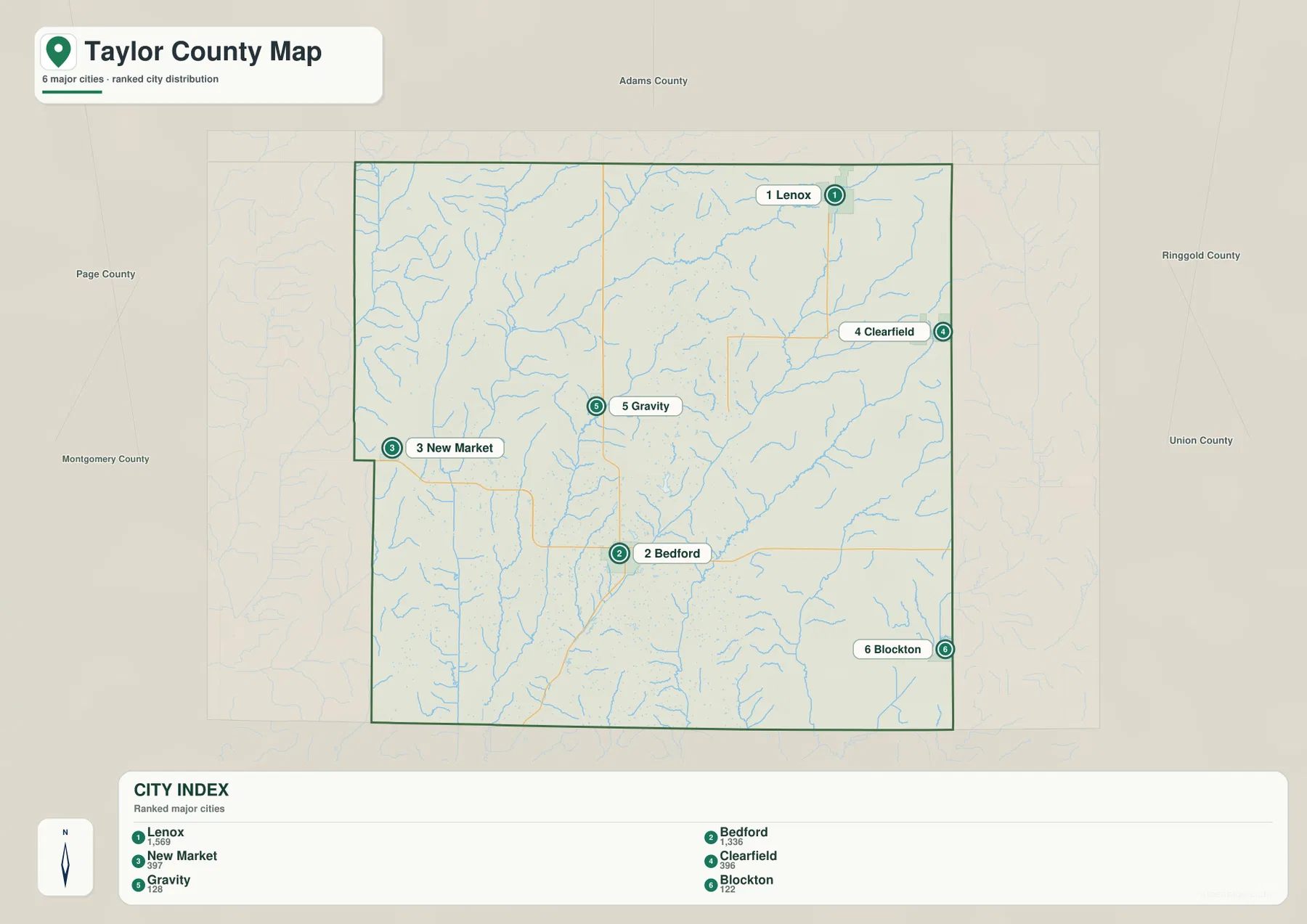
The population figures printed in the city index should be treated as part of this map set rather than as a replacement for the latest official estimate. Population totals change with source year and revision schedules. The strongest information here is spatial: Lenox is far north of Bedford, New Market and Clearfield sit on opposite sides of the county, and Blockton is well southeast of Gravity. If exact driving time or current road access is the goal, a navigation service is the better tool. For a county report, school project, or quick printed comparison, this reduced city map is often easier to read than a dense street map.
The city map also provides a useful bridge to the natural geography maps. Once Bedford, Lenox, Clearfield, and New Market are fixed in mind, it becomes easier to interpret which river branches and lakes are closest to each part of the county. That is particularly helpful in Taylor County because several waterways carry similar One Hundred and Two River names, and the surrounding rolling terrain can make the drainage network look complex at first glance.
One Hundred and Two River branches and Lake of Three Fires
The terrain and water map makes Taylor County’s drainage pattern the main subject. On the west side, the West Fork One Hundred and Two River runs generally north to south, with additional western and middle branches nearby. Farther east, the Middle Fork and East Fork One Hundred and Two River systems create long, narrow corridors through the central and southern parts of the county. The East Nodaway River appears near the western edge. Dozens of smaller tributaries feed these larger channels, so the county is divided by repeated stream valleys rather than by one dominant river valley.
Lake of Three Fires is the most recognizable named lake on the map and lies near Bedford in the south-central part of the county. The Iowa Department of Natural Resources identifies Lake of Three Fires State Park as a Taylor County park and describes an 85-acre lake at its center. The county water map is useful because it places that lake within the wider drainage landscape rather than isolating it as a recreation site. Windmill Lake appears farther west, while Waterworks Lake and Wilson Lake are in the northeastern portion of the county.
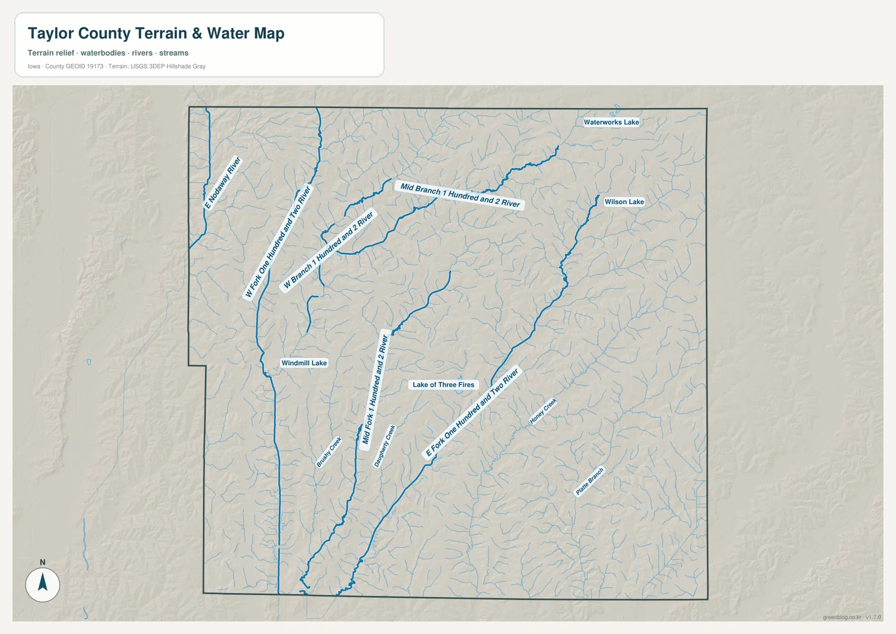
Smaller names such as Brandy Creek, Dumbunny Creek, Honey Creek, and Platte Branch add local detail. Following those channels across the shaded relief shows how tightly the drainage network is tied to the shape of the land. The streams occupy narrow low corridors, while ridges rise between them. This map is therefore useful for understanding where a named creek sits and how it connects to a larger branch, but it is not a flood-hazard map, parcel map, navigation chart, or source for real-time water conditions. Flood planning and property decisions require current specialized official data.
Comparing the water map with the city map reveals several practical relationships. Bedford is close to Lake of Three Fires and the central branches of the One Hundred and Two River system. New Market and Gravity lie closer to the western drainage network and the East Nodaway side of the county. Lenox and Clearfield sit nearer the northern and northeastern lakes and tributaries. The point is not that each city belongs to a separate watershed in a simple way, but that the county’s settlements occupy different parts of a highly branched landscape.
Rolling uplands between valleys from about 305 to 398 meters
The elevation map gives the strongest visual explanation for Taylor County’s rolling terrain. Its legend shows an actual mapped range of about 305 to 398 meters, with a mean near 361 meters. Green tones represent lower ground, while yellow, orange, and brown tones mark progressively higher areas. Rather than one broad flat plain, the county contains many narrow green valleys separated by higher ridges. The pattern is especially clear along the western and central river branches, where low corridors extend for long distances through more elevated terrain.
This visual pattern matches the county’s official hazard mitigation plan, which places Taylor County in the Southern Iowa Drift Plain. The plan explains that old glacial deposits were reshaped by stream erosion into steeply rolling, well-drained hills and valleys. The elevation map shows exactly that kind of repeated relief: stream channels carve into the land, and the ground rises again between them. The result is not mountainous terrain, but it is much more textured than a uniformly level agricultural plain.
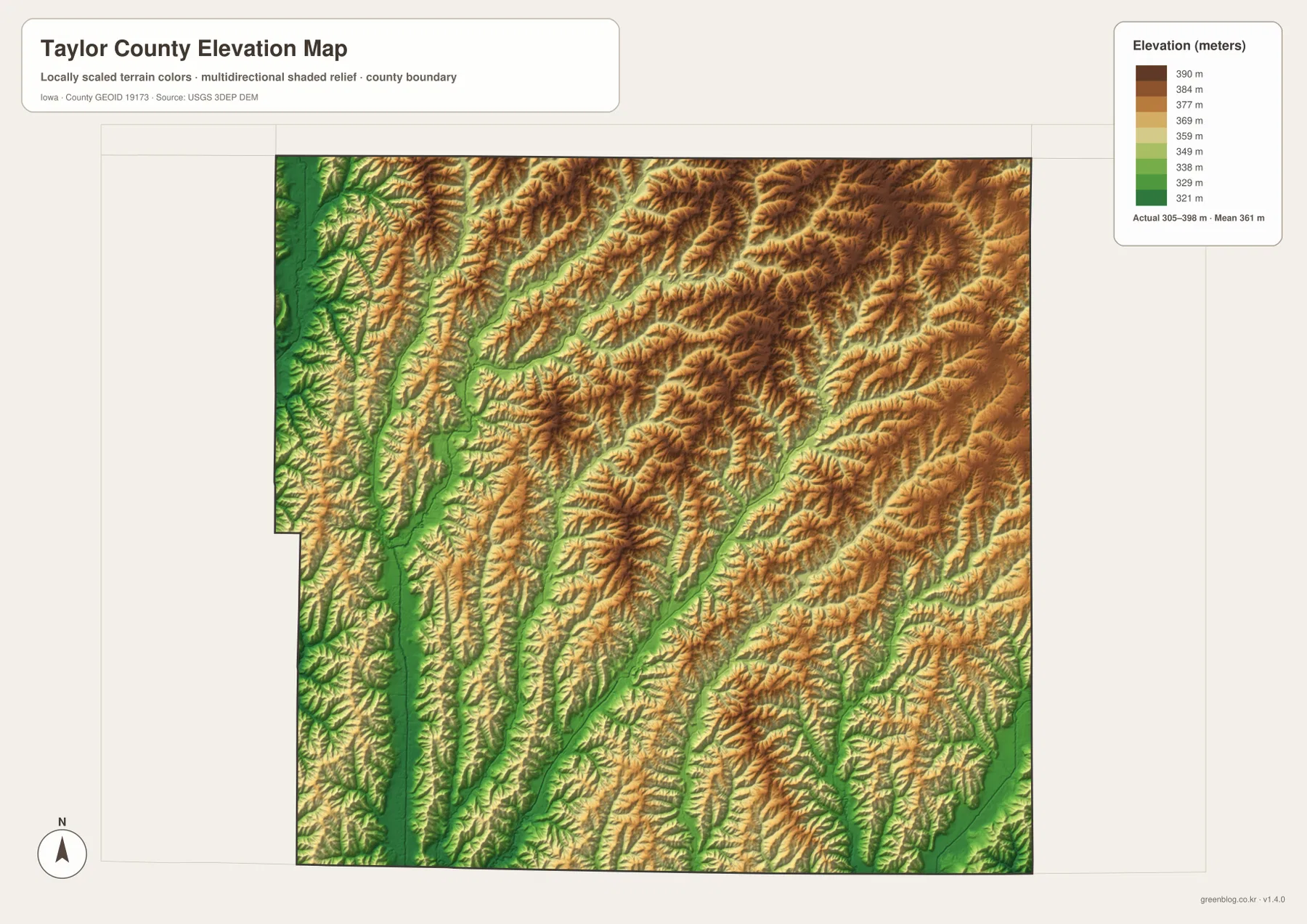
Side-by-side comparison with the water map is particularly revealing. Many of the green corridors on the elevation image line up with the One Hundred and Two River branches and smaller tributaries. Higher ground fills the spaces between those channels, especially across the northern and eastern portions of the county, but even those uplands are cut by narrow valleys. This explains why the terrain appears ribbed or folded at a county scale: repeated drainage has separated the uplands into many smaller ridges and slopes.
The elevation surface is designed for regional interpretation, not precise site measurement. It can show that a valley floor is lower than the nearby upland and that some parts of the county are generally higher than others. It should not be used to determine the exact elevation of a building, parcel corner, road project, or construction site. Those tasks require the underlying elevation data or professional surveying. For general geography, however, the map makes the relationship between streams and terrain far easier to understand than a road map alone.
Choosing the right Taylor County map for the question
Use the county reference map when the question involves a town, road, or boundary. It contains the most place names and gives Highway 2, Highway 25, and Highway 148 enough prominence to serve as location anchors. The city map is better when the goal is to compare the six highlighted communities without the distraction of many local roads. Its value is clarity: Lenox in the north, Bedford in the southern half, New Market and Clearfield near opposite sides, and Blockton in the southeast can be understood at a glance.
The water map is the strongest choice for Lake of Three Fires, the One Hundred and Two River branches, the East Nodaway River, and smaller named creeks or lakes. The elevation map answers a different question by showing why those waterways occupy long low corridors and how the uplands rise between them. Pairing the water and elevation maps works especially well for a regional geography lesson or a report about the Southern Iowa Drift Plain. Pairing the city and county maps is better for settlement, road, or county-orientation topics.
Print size matters. The county map contains many small labels, so it benefits from a full-page print or the original high-resolution file. The city map is much less crowded and remains readable at smaller sizes. The water map contains numerous tributary labels that are easier to follow when enlarged, while the elevation map depends on color gradients and shaded relief. A color screen or color printer preserves those terrain differences better than black-and-white output. The archive below keeps all four original JPG files together for larger viewing and printing.
Frequently Asked Questions
What is the best city to use as a starting point on a Taylor County map?
Bedford is the most useful starting point because it is the county seat and lies along Highway 2 in the southern half of the county. Once Bedford is located, Lenox can be found to the north, New Market and Gravity to the west, Clearfield to the east, and Blockton to the southeast. Lake of Three Fires is also close to the Bedford area, so the city provides a convenient link between the road, settlement, and water maps.
Where is Lake of Three Fires on the county water map?
It appears in the south-central part of Taylor County near Bedford, surrounded by the branching drainage network of the One Hundred and Two River system. The Iowa Department of Natural Resources identifies the lake as the central feature of Lake of Three Fires State Park. The county map is useful for regional location, but visitors who need campground roads, trails, boat ramps, or other park details should use the official Iowa DNR park map as well.
Can the 305–398 meter elevation range be used for surveying?
No. The elevation map is designed to compare county-wide terrain, showing lower valleys and higher uplands in a generalized shaded surface. The legend’s range of about 305 to 398 meters and mean near 361 meters are useful for understanding relief across Taylor County, but they are not parcel-level survey measurements. Engineering, construction, or boundary work should use the underlying USGS elevation data or a professional survey.
Map File Information
The download contains the same county, city, water-and-terrain, and elevation maps shown on this page as full-resolution JPG files. The originals are better suited to close inspection and printing than the lightweight WebP previews used in the article.
- Included Files: Taylor County reference map, city distribution map, water and terrain map, and elevation map
- Printable Size: 3638 × 2572 px for each JPG
Related Maps
Sources and References
The map observations are supported by the supplied map previews and authoritative county, state, and federal references. Taylor County’s official site provides local administrative context, Iowa DNR documents Lake of Three Fires, and the national sources below describe the boundary, hydrography, and elevation datasets commonly used for county mapping.
- Taylor County, Iowa official website – county overview and courthouse information in Bedford
- Iowa DNR Lake of Three Fires State Park – official park and lake information for Taylor County
- Taylor County Hazard Mitigation Plan – official description of the Southern Iowa Drift Plain and county terrain
- U.S. Census Bureau TIGER/Line Shapefiles – county boundary, roads, and place-reference data
- USGS National Hydrography – national river, stream, and waterbody data
- USGS 3D Elevation Program – elevation data and 3DEP documentation
Green Map creates custom-edited map images using open geographic data sources such as geoBoundaries, Natural Earth, OpenStreetMap, and government open data.
These maps are edited visual materials, not raw data files, and are provided for education, documents, presentations, and graphic reference.