Mackinac County occupies one of Michigan’s most distinctive geographic settings: the southeastern edge of the Upper Peninsula, the northern shore of the Straits of Mackinac, and offshore islands that include Mackinac Island and Bois Blanc Island. St. Ignace is the clearest mainland reference point, where I-75 approaches the straits and US-2 turns west along the Lake Michigan side of the county. The maps on this page separate that complicated shape into roads and boundaries, major cities, waterways, and elevation. High-resolution JPG originals of all four maps are also available in the downloadable ZIP below.
The Library of Michigan identifies St. Ignace as the county seat and lists Emmet, Chippewa, Luce, and Schoolcraft as adjacent counties. That official description makes more sense when the supplied maps are viewed together. Mackinac County is not simply a block of mainland territory: its western mainland stretches a long way toward Naubinway, its eastern edge is cut by bays and peninsulas, and large areas of county geography lie across open water. Starting at St. Ignace, following US-2 west, and then adding the islands and inland river systems provides a much clearer orientation than trying to read every label at once.
Table of Contents
St. Ignace anchors the road network while US-2 traces the long southern mainland
On the general county map, St. Ignace sits at the southeastern tip of the Upper Peninsula mainland and serves as the main junction for understanding the road pattern. I-75 approaches from the north and continues toward the Straits of Mackinac, while US-2 bends west from the St. Ignace area and follows the southern side of the county. Farther west, Naubinway appears close to the Lake Michigan shore. The result is a county whose principal east-west road connection hugs the southern mainland rather than cutting directly across the higher interior.
Several state routes branch away from that basic framework. M-117 appears in the western part of the county and provides a northward connection from the US-2 corridor. M-123 begins north of St. Ignace and heads into the eastern Upper Peninsula interior, while M-134 is visible farther east along the coastal side of the county. These routes are useful map references because settlement is much less continuous than in a metropolitan county. When place names become sparse, a numbered highway and the shoreline often provide the most practical way to establish direction.
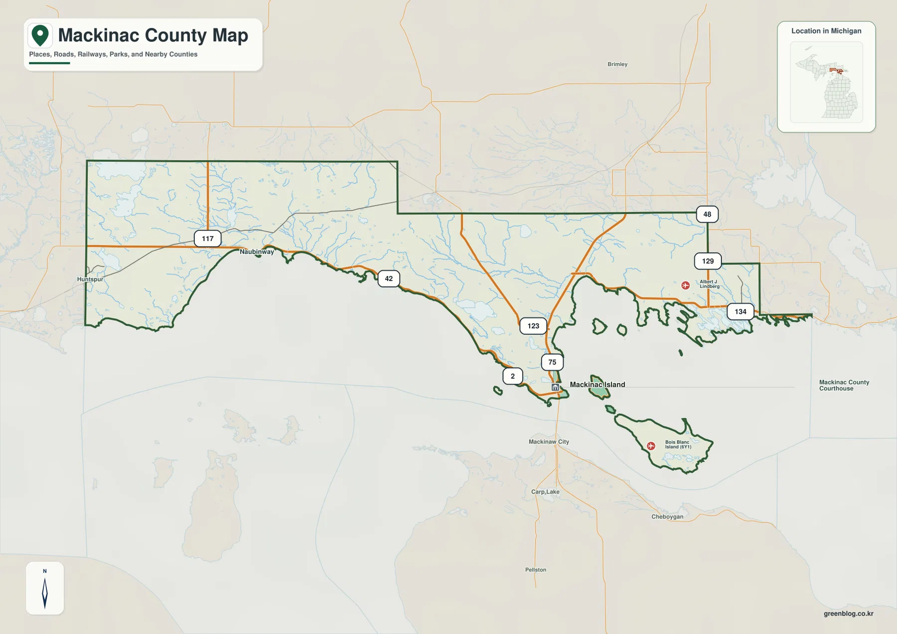
The boundary itself deserves attention because water separates major parts of the county. The western mainland borders Schoolcraft County, the northern side meets the Luce and Chippewa directions, and the southern edge faces the Straits and adjoining Great Lakes waters. Mackinac Island and Bois Blanc Island appear as separate land areas within the county outline. For classroom or presentation use, keeping those islands in frame is important; a mainland-only crop would give an incomplete impression of Mackinac County. The boundary shown here is a county-scale reference, not a parcel survey or legal property map.
The two-city index highlights a mainland center and an island city
The city map is intentionally simple. It ranks St. Ignace first and Mackinac Island second, placing the two labeled cities on opposite sides of water near the southeastern end of the county. Their geographic separation matters more than the small visual distance between the markers. St. Ignace connects directly to the Upper Peninsula road network, whereas Mackinac Island is an offshore city with no ordinary highway connection to the mainland. The city layer therefore works best as a quick orientation map rather than as a driving-distance diagram.
Official Michigan DNR information for Straits State Park describes the St. Ignace waterfront as a place with views across the Straits of Mackinac and toward the Mackinac Bridge. Mackinac State Historic Parks, meanwhile, notes that more than 80 percent of Mackinac Island is state park land and describes ferry or air access to the island. Those facts reinforce what the map shows visually: the county’s two most prominent city labels belong to communities that are close geographically but function in very different physical settings.
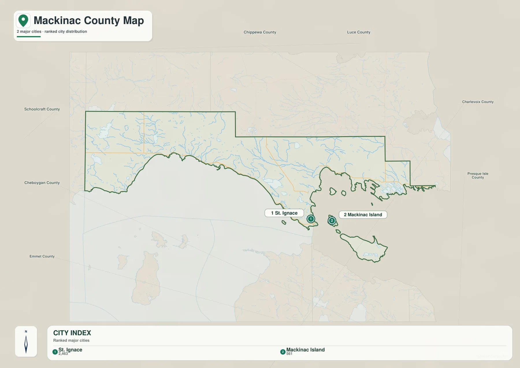
Only two cities are ranked on this layer, but that should not be read as a complete settlement inventory. Communities such as Naubinway and other smaller places remain important for local orientation and appear more clearly on the general map. The value of the city index is its restraint: it gives a first-time reader two memorable anchors before the road, lake, and river labels are introduced. When the city map is followed by the general map, the western mainland and the island portions of the county become much easier to place relative to one another.
Brevoort Lake and the Carp River system organize the central mainland water pattern
The terrain-and-water map reveals how much detail is hidden behind the simple coastal road pattern. Brevoort Lake stands out west of St. Ignace as one of the largest labeled inland lakes, with Little Brevoort River and the Carp River system nearby. South Branch Carp River is labeled farther north, and Pine River appears in the eastern interior. Bay City Lake is also marked on the east side. These features show that the mainland is crossed by several separate drainage systems rather than one dominant river valley.
Western Mackinac County has its own cluster of water references. Milakokia Lake and Millecoquins Lake are labeled inland from the Lake Michigan shore, while Rock River and Black River run through the western part of the map. This matters when reading US-2: the highway may create the impression of a narrow coastal strip, but the water layer shows a much broader interior filled with lakes, tributaries, wet lowlands, and subtle divides. For exact watershed boundaries or current hydrographic data, the USGS National Hydrography products are more appropriate than this generalized reference map.
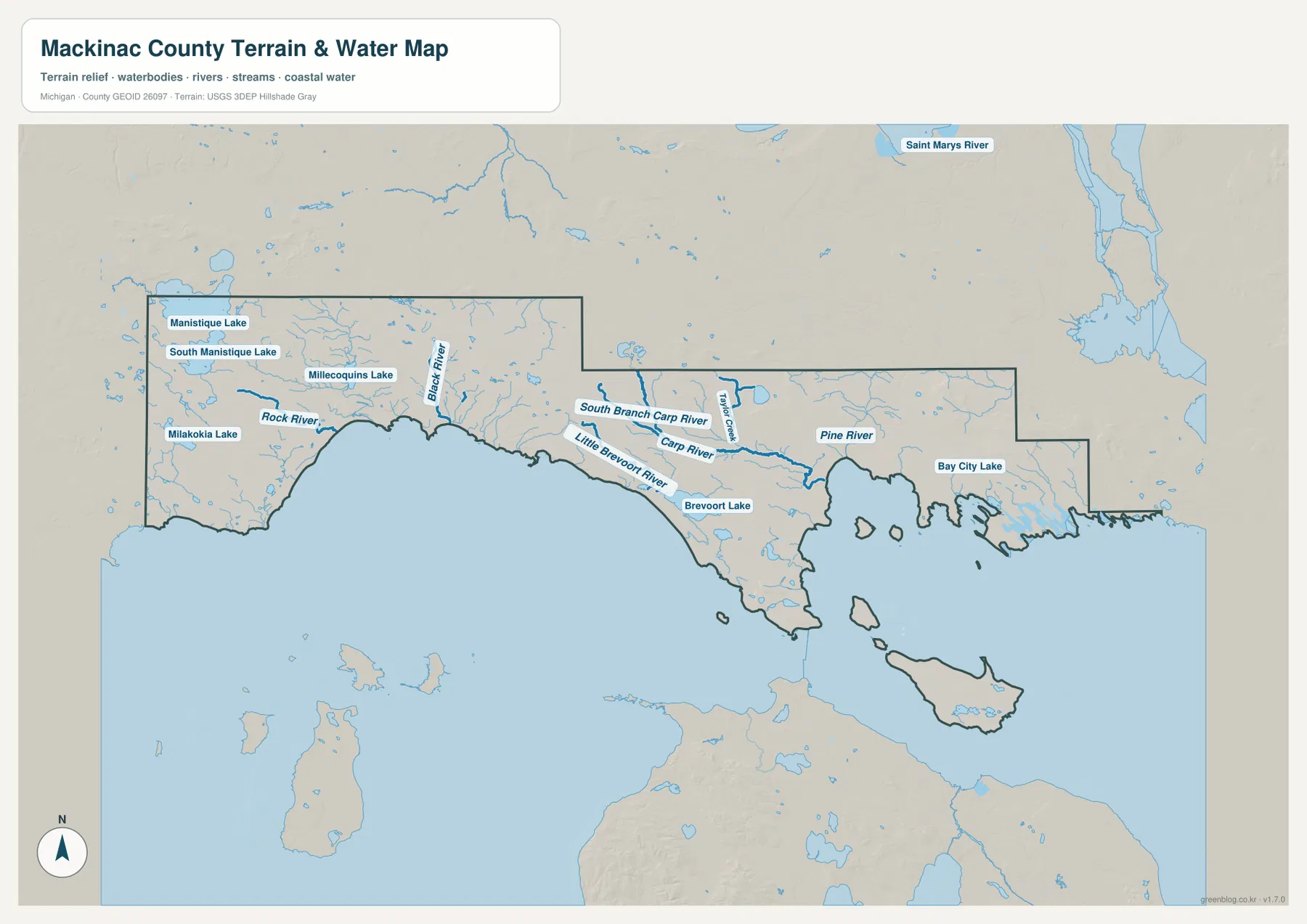
The offshore geography is equally important. Mackinac Island and Bois Blanc Island are separated from the Upper Peninsula mainland by broad water, and St. Ignace sits on the northern side of the Straits of Mackinac where Lake Michigan and Lake Huron meet. The water map makes those separations easier to see than the road layer does. It is useful for geographic orientation, but it is not a navigation chart and does not provide depth, channel markers, current conditions, flood elevations, legal wetland boundaries, or boating guidance.
Elevation rises away from the southern shore into a higher northern interior
The elevation map shows an actual mapped range of roughly 176 to 303 meters, with a mean near 218 meters. Low terrain is concentrated along much of the southern Lake Michigan and Straits shoreline and appears in darker green. Moving inland, the colors transition through lighter green and yellow before reaching broad brown uplands near the northern part of the mainland. Smaller elevated areas also appear toward the eastern interior. The difference is not mountainous by western U.S. standards, but more than 120 meters of local county-scale relief is enough to create a clear contrast between shorelands and inland hills.
Waterways help explain the shape of that relief. Lower corridors around Brevoort Lake, the Carp River system, and other streams remain visibly greener than nearby uplands. The northern mainland shows more broken shaded relief, with small ridges and valleys cutting across the higher surface. Mackinac Island and Bois Blanc Island are generally lower than the highest mainland uplands, although both islands contain their own local changes in elevation. Comparing the elevation and water maps side by side makes the drainage pattern easier to understand without relying on technical contour-line interpretation.
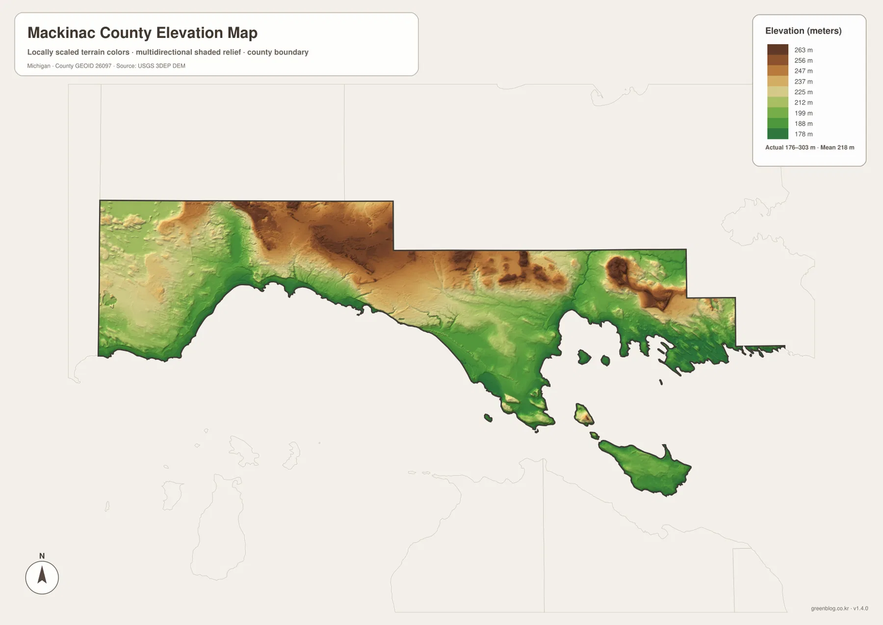
This elevation surface is designed for broad geographic comparison. It can help with understanding why some river corridors occupy lower green terrain and why the county’s interior looks hillier than its coast, but it should not be treated as survey-grade information. Construction, drainage design, road engineering, parcel elevation, and other precision work require original elevation data and, when necessary, field surveying. USGS 3D Elevation Program products are the appropriate source when numeric accuracy is important.
A mainland-first reading order keeps the islands and straits from becoming confusing
For a first look at Mackinac County, begin with St. Ignace and the I-75/US-2 junction area. Follow US-2 west toward Naubinway to establish the long southern mainland, then identify M-117 in the west and M-123 north of St. Ignace. After that mainland framework is clear, add Mackinac Island and Bois Blanc Island. This sequence separates road-connected territory from island geography and prevents the water-filled county outline from looking more complicated than it really is.
Next, switch to the terrain-and-water map and locate Brevoort Lake, Carp River, Pine River, Milakokia Lake, and Millecoquins Lake. These features fill in the interior behind the highway corridor. The elevation layer can then be used to compare the green southern lowlands with the higher brown terrain to the north. The purpose of this sequence is not to make travel-time or engineering judgments; it is simply a clear way to combine four different kinds of geographic information without asking one map to do everything.
The WebP images embedded in the article are optimized for convenient screen viewing. For printing, classroom handouts, large presentations, or closer inspection of labels, use the 3638 × 2572 pixel JPG originals in the ZIP. The general map is the best starting point for roads and boundaries, the city map is useful for the St. Ignace–Mackinac Island relationship, the water map provides named lakes and rivers, and the elevation map adds broad relief. None of these files should replace legal boundary surveys, parcel records, live road information, nautical charts, flood maps, or engineering-grade elevation products.
Frequently Asked Questions
Are Mackinac Island and Bois Blanc Island part of Mackinac County?
Yes. The supplied county boundary includes both islands along with the Upper Peninsula mainland. Keeping the islands visible is important when presenting the county as a whole because a mainland-only map would omit a significant part of its geography.
Which map best shows the relationship between St. Ignace and Mackinac Island?
The city map is the quickest option because it emphasizes those two places and their position across the surrounding water. Use the general map next if you also need highways, the county outline, and the position of Bois Blanc Island.
Can the 176–303 m elevation range be used for surveying or construction?
No. The elevation layer is a generalized county-scale surface intended to show broad high and low areas. Parcel elevations, drainage grades, construction measurements, and road engineering require original elevation data and, where appropriate, a professional site survey.
Map File Information
The ZIP contains high-resolution JPG originals of the Mackinac County general map, city map, terrain-and-water map, and elevation map. These originals are larger than the WebP images shown in the article and are better suited to printing and close inspection.
- Included Files: Use only the versions confirmed in the article and supplied images
- File Type: Use the confirmed download contents
- Intended Use: Printing, education, presentations, and map-based projects
Related Maps
Sources and references
- Library of Michigan – Mackinac County Guide: official county-seat and neighboring-county reference.
- Michigan DNR – Straits State Park: official information on the St. Ignace waterfront, Lake Huron, and the Straits of Mackinac setting.
- Mackinac Island State Park: official information on Mackinac Island’s park landscape and visitor geography.
- U.S. Census Bureau TIGER/Line Shapefiles: official reference data for county boundaries and roads.
- USGS National Hydrography: reference information for rivers, streams, and lakes.
- USGS 3D Elevation Program: elevation-data reference.
Green Map creates custom-edited map images using open geographic data sources such as geoBoundaries, Natural Earth, OpenStreetMap, and government open data. These maps are edited visual materials, not raw data files, and are provided for education, documents, presentations, and graphic reference.