Luce County occupies a broad part of Michigan’s eastern Upper Peninsula, with Lake Superior along the north and Newberry serving as the main settlement and county seat in the southern half. The general map is anchored by M-28 at Newberry, but the farther north you look, the more the county is defined by long forest roads, rivers, inland lakes, and the Lake Superior shore. This page separates those themes so roads, settlement, water, and relief are easy to compare. High-resolution JPG originals of all four supplied maps are also available together in the download box below.
The official Luce County website describes the county as part of Michigan’s Eastern Upper Peninsula and identifies Newberry as the county seat. It also highlights extensive public land, inland lakes, rivers and streams, and Lake Superior shoreline as major parts of the county’s character. Those features are immediately visible in the supplied maps. Roads are most concentrated around Newberry and the M-28 corridor, while the center and north contain much larger gaps between settlements and a much denser pattern of waterways. For that reason, Luce County makes more sense when the road map is read together with the water and elevation maps rather than as a road network alone.
Table of Contents
Newberry and M-28 anchor the south while M-123 marks the eastern side
Newberry is the clearest starting point on the general county map. M-28 runs east–west through the community, providing a strong reference line across the southern part of Luce County. County roads extend north from this corridor, including routes labeled 415 and 407, while roads 421, 422, and 418 reach into the western and northwestern interior. M-123 appears near the eastern side of the county and provides another useful orientation line. In a county with relatively few large settlements, these numbered roads are often more helpful than place names for keeping track of location.
North of Newberry, the road network becomes progressively more open. Deer Park is labeled near the Lake Superior side, County Road 412 follows part of the northern area, and the Two Hearted Airstrip appears close to the coast. Luce County Airport is shown southeast of Newberry. These landmarks help connect the sparse road network to recognizable points without suggesting that every road is paved or equally suitable for travel. The map is useful for regional orientation, but it is not a live road-condition map and should not be used to determine seasonal closures, surface condition, or access restrictions on forest roads.
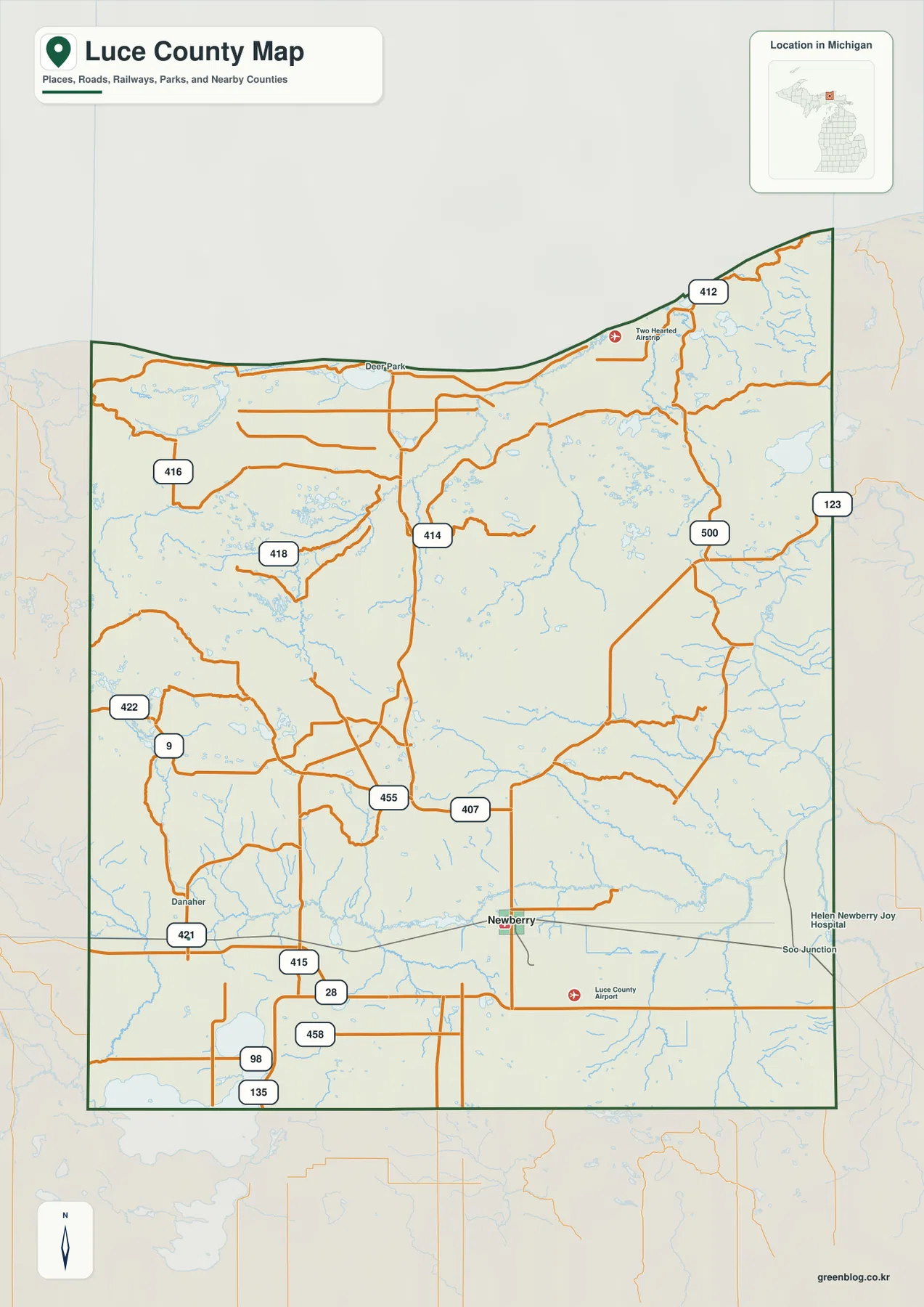
The county boundary provides another useful frame. The Library of Michigan lists Alger, Chippewa, Mackinac, and Schoolcraft as adjacent counties, while Lake Superior forms the northern coastal edge. The supplied map shows roads continuing beyond the Luce County line, making it possible to see the direction of regional connections even when the destination lies outside the county. The boundary is appropriate for county-scale reference, not for parcel or property decisions. Anyone who needs a legal boundary, land ownership record, or tax parcel should use current county GIS and official land records rather than relying on a generalized map image.
The place-ranking map highlights Newberry as the single major settlement
The city-style comparison map is unusually simple because it highlights only Newberry as the ranked major place. That makes this version less about comparing several cities and more about locating the county’s main settlement within a large rural landscape. Newberry sits in the southern half of Luce County, well inland from Lake Superior, and provides the most practical reference point for following M-28 or turning north toward the interior. The absence of multiple ranked places on this simplified map should not be read as an absence of communities; it reflects the map’s narrow purpose of emphasizing the primary settlement.
Used together with the general map, the simplified view becomes more useful. From Newberry, M-28 gives a clear east–west orientation, while county roads lead north toward the Lake Superior side and the river country. The eastern side can then be related to M-123, and the more remote western interior can be found by following the county-road network away from Newberry. For classroom or presentation use, this sequence works well: first establish where Newberry sits, then switch to the detailed map to add roads, airports, shoreline, and neighboring areas without overwhelming the viewer at the beginning.
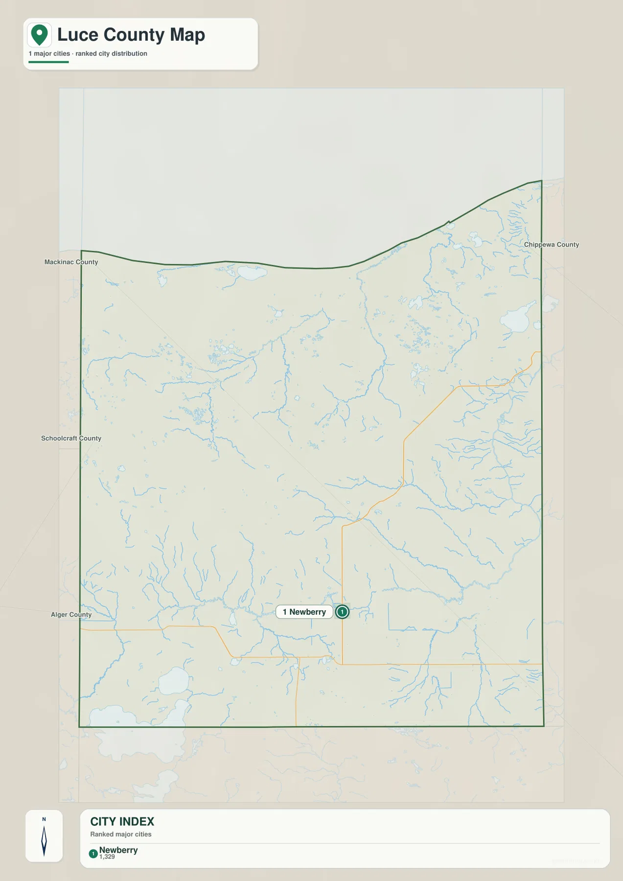
Newberry also works as a mental reference point when moving to the water map. Muskallonge Lake and the Lake Superior shore are far to the north, the Two Hearted River system occupies much of the northern and northeastern half, and the Tahquamenon River appears toward the west and southwest. North Manistique Lake and the direction of Manistique Lake appear near the southern edge. Remembering Newberry’s location in the south-central part of the county makes it easier to understand how widely separated these water features are.
Muskallonge Lake and the Two Hearted branches define the northern water landscape
The terrain-and-water map changes the emphasis completely. Lake Superior fills the northern edge, with Muskallonge Lake just inland from the shore and Bodie Lake and Betsy Lake farther east. Michigan DNR describes Muskallonge Lake State Park as lying about 28 miles northwest of Newberry between Lake Superior and Muskallonge Lake, which matches the close relationship of the two water bodies shown here. The Blind Sucker River reaches the northwestern side, while a much more complex set of channels appears across the north and northeast around the Two Hearted River system.
The Two Hearted drainage is not represented as one simple river line. North Branch Two Hearted River approaches from the west, East Branch Two Hearted River extends across the northeastern interior, and Little Two Hearted River is labeled closer to the Lake Superior side. Numerous smaller streams and lakes fill the spaces between those named channels. Luce County’s official site also identifies the Two Hearted River among the area’s notable rivers and streams. On the map, this network explains why the northern half appears much more intricate when water is emphasized than when only roads and settlements are shown.
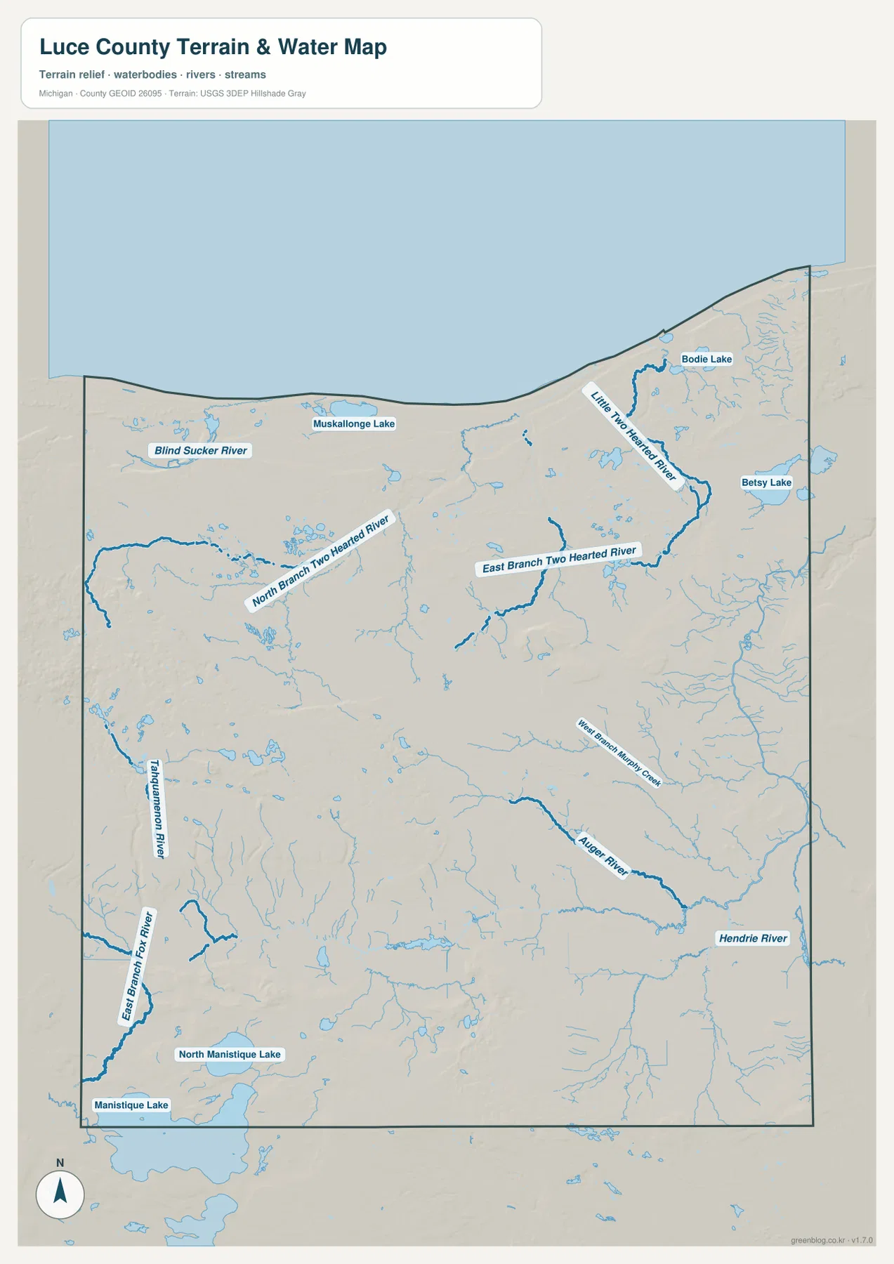
Farther south and west, the drainage pattern becomes more varied. The Tahquamenon River is labeled along the western side, with East Branch Fox River appearing in the southwest. Auger River, Hendrie River, and West Branch Murphy Creek occupy parts of the eastern and southeastern interior. Near the southern edge, North Manistique Lake and the direction of Manistique Lake are visible. These features show that Luce County is divided among several headwater and river systems rather than being organized around a single dominant valley. The map is intended for geographic reference; it does not provide water depth, flood elevation, navigability, legal wetland boundaries, or current boating conditions.
Low Lake Superior shorelands contrast with higher western and interior ridges
The elevation map shows an actual mapped range of roughly 183 to 359 meters, with a mean near 236 meters. The Lake Superior shore is among the lowest parts of the county and appears in darker green. Moving inland, broad areas shift through lighter green and yellow-green before reaching higher brown terrain. The most extensive high area is on the western and west-southwestern side of the county, while isolated higher hills also appear in the east-central and northeastern interior. Luce County is not mountainous in the conventional sense, but the difference between shoreline lowlands and inland uplands is substantial enough to stand out clearly at county scale.
Comparing relief with the water map makes several valleys easier to recognize. The Two Hearted branches occupy lower corridors through the northern interior, and the Tahquamenon River follows another lower route toward the west. Shaded relief also reveals slopes around the larger western upland and smaller isolated hills farther east. In the southern part of the county, lower flats are mixed with modest ridges and depressions. This pattern helps explain why rivers, wetlands, and small lakes appear in so many different parts of the county instead of being confined to one central basin.
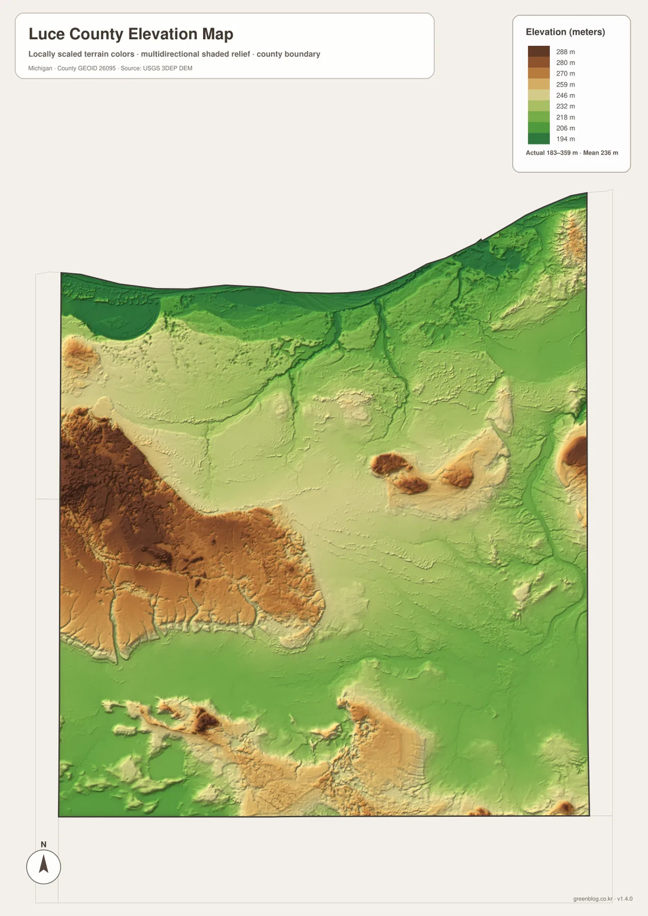
This is a generalized elevation surface designed for regional comparison. It is appropriate for seeing broad differences between the shore, river valleys, and uplands, but it should not be treated as survey-grade elevation for a building site, road project, drainage design, or engineering calculation. For those purposes, USGS 3D Elevation Program products and site-specific surveying are the appropriate sources. For general geographic use, the map works especially well beside the water layer because lower green corridors often correspond with the larger river systems shown on the terrain-and-water map.
Begin at Newberry, then add the shoreline, rivers, and relief one layer at a time
A practical reading order starts with Newberry and M-28. Once that southern reference point is fixed, follow M-123 on the eastern side and the 407 and 415 county-road directions northward. Then switch to the water map and locate Muskallonge Lake, the Two Hearted branches, Blind Sucker River, and the Tahquamenon River. This approach avoids trying to absorb every road and water name at once. It also shows how far the northern shore and river country lie from the county seat compared with features in the southern interior.
The elevation map adds the final piece. Low Lake Superior shorelands and river corridors appear green, while higher western and interior hills shift toward yellow and brown. The goal is not to infer road difficulty or construction conditions from the colors, but to understand the broad setting in which the roads and rivers sit. Because the themes are separated, readers can choose the simplest map for the task: the general map for roads and boundaries, the Newberry-focused map for a quick settlement reference, the water map for named rivers and lakes, and the elevation map for broad relief.
The WebP images in the article are optimized for convenient web viewing. For printing, classroom material, large-screen presentation, or closer inspection of labels, use the 2572 × 3638 pixel JPG originals in the downloadable ZIP. They are appropriate for general orientation, education, and trip planning, but they are not legal boundary surveys, parcel maps, flood maps, navigation charts, forest-road status maps, or engineering elevation products. Property, regulatory, construction, and live-access decisions should always rely on current official sources.
Frequently Asked Questions
What is the easiest reference point to find first in Luce County?
Start with Newberry. It is the county seat and sits on M-28 in the southern half of the county. From there, the general map makes it easier to follow routes north toward the Lake Superior side and east toward the M-123 corridor.
Is the Two Hearted River shown as one single channel?
No. The supplied water map labels North Branch Two Hearted River and East Branch Two Hearted River separately, and it also shows Little Two Hearted River nearer the Lake Superior side. The similar names make it important to check each branch individually.
Can the 183–359 m elevation range be used for surveying or construction?
No. The elevation map is a generalized county-scale surface for comparing broad high and low areas. Exact parcel elevations, drainage grades, road design, and construction measurements require original elevation data and, when appropriate, a professional site survey.
Map File Information
The ZIP contains high-resolution JPG originals of the Luce County general map, Newberry place map, terrain-and-water map, and elevation map. The originals are larger than the WebP images shown in the article and are better suited to printing and close inspection.
- Included Files: Use only the versions confirmed in the article and supplied images
- File Type: Use the confirmed download contents
- Intended Use: Printing, education, presentations, and map-based projects
Related Maps
Sources and references
- Luce County official website: county-seat information and an overview of Lake Superior shoreline, rivers, lakes, and local recreation.
- Michigan DNR – Muskallonge Lake State Park: official information on the park between Muskallonge Lake and Lake Superior northwest of Newberry.
- U.S. Census Bureau TIGER/Line Shapefiles: official reference data for county boundaries and roads.
- USGS National Hydrography: reference information for rivers, streams, and lakes.
- USGS 3D Elevation Program: elevation-data reference.
Green Map creates custom-edited map images using open geographic data sources such as geoBoundaries, Natural Earth, OpenStreetMap, and government open data. These maps are edited visual materials, not raw data files, and are provided for education, documents, presentations, and graphic reference.