Hillsdale County occupies the southern tier of Michigan’s Lower Peninsula, with Hillsdale and Jonesville forming the main central-northern settlement area and smaller communities such as Litchfield, Reading, Camden, Pittsford, and Waldron spread across the county. The terrain is far from uniform: higher rolling country occupies much of the central and northeastern interior, while lower river valleys become especially visible toward the southeast.
This page uses the supplied general county, city-distribution, terrain-and-water, and elevation maps to explain those differences. High-resolution JPG originals are available together in a ZIP download for printing, classroom materials, presentations, and detailed local reference. Reading the maps together makes it easier to connect roads, town locations, the St. Joseph and Kalamazoo river systems, and the county’s surprisingly strong relief.
The road network is easiest to understand from Hillsdale and Jonesville. US-12 runs through the Jonesville–Allen side of the county, M-34 provides a major east-west reference through the Hillsdale–Pittsford corridor, M-49 organizes the western side near Reading and Camden, and M-99 provides another north-south reference through the central-southern county.
Table of Contents
Hillsdale and Jonesville anchor the US-12 and M-34 road pattern
Hillsdale and Jonesville are the strongest settlement references on the general county map. Jonesville lies along the US-12 corridor, while Hillsdale sits farther south near M-34 and M-99. Hillsdale Hospital is also labeled within the city area, making the county center easy to locate.
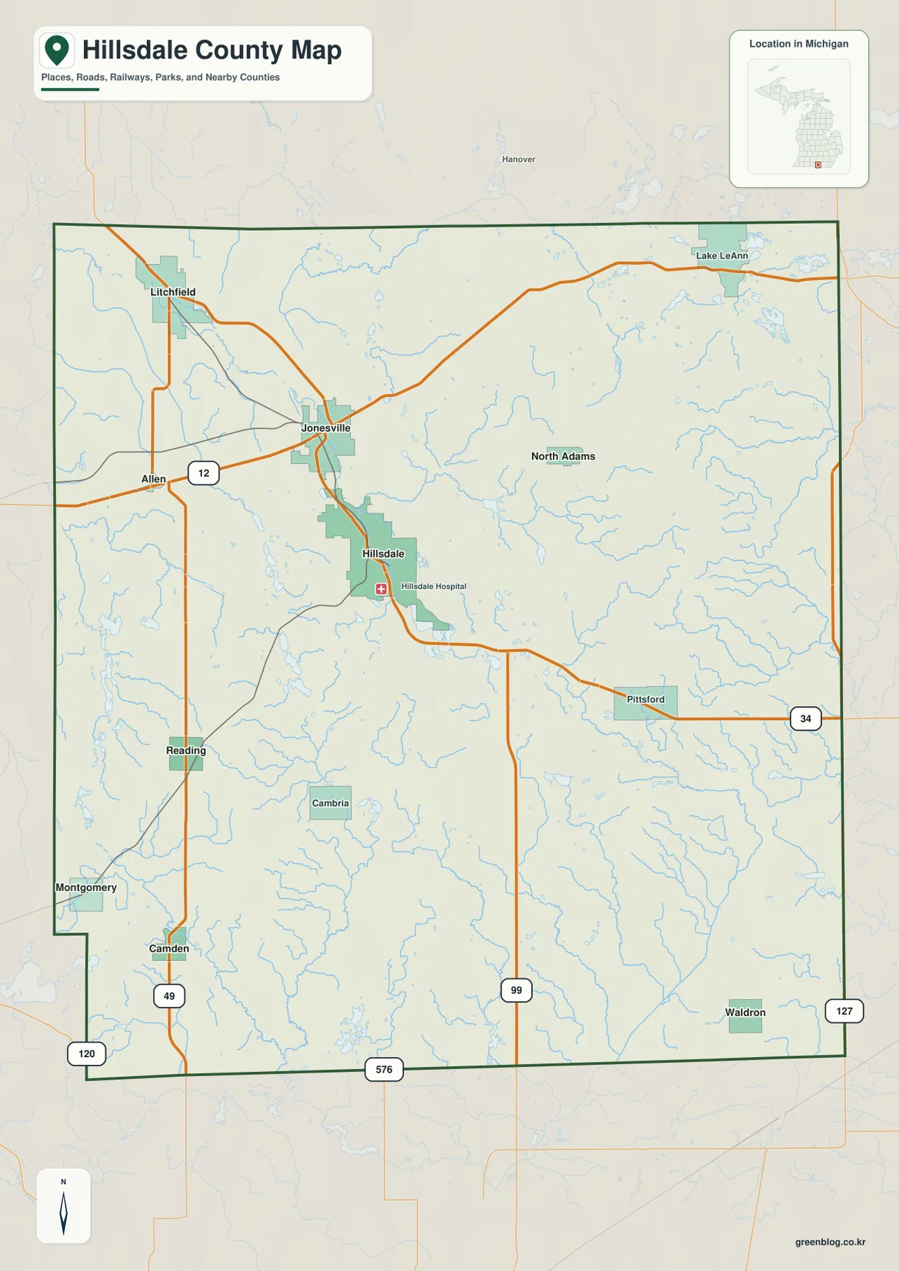
West of Jonesville, Allen and Litchfield provide the main settlement references. US-12 offers the clearest east-west orientation in this part of the county, while north-south local routes lead toward Reading and Camden. Streams frequently cross the road pattern, so the water map adds useful context to the relatively sparse western network.
East of Hillsdale, M-34 continues toward Pittsford and the eastern county. North Adams appears nearby as a smaller settlement reference. There are fewer large communities in this direction, and the drainage network becomes more visually prominent than the urban road grid.
Reading and Camden organize the southwestern side. M-49 provides the strongest north-south reference through this part of the county, while route labels near the southern boundary indicate connections toward Indiana and Ohio. Settlement is more dispersed here than around Hillsdale and Jonesville.
This is a regional reference map rather than a live navigation product. It does not show current traffic, construction, accidents, seasonal restrictions, or temporary closures. Current driving routes and travel conditions should be checked with up-to-date Michigan transportation information or a live navigation service.
Six highlighted communities span the county from Litchfield to Waldron
The city-distribution map highlights Hillsdale, Jonesville, Litchfield, Reading, Camden, and Waldron while removing most road detail. Hillsdale sits near the center, Jonesville is to the north, Litchfield occupies the northwest, Reading and Camden lie in the southwest, and Waldron is near the southeast. There are no connector lines or distance measurements, so this map should be used for relative position rather than travel distance.
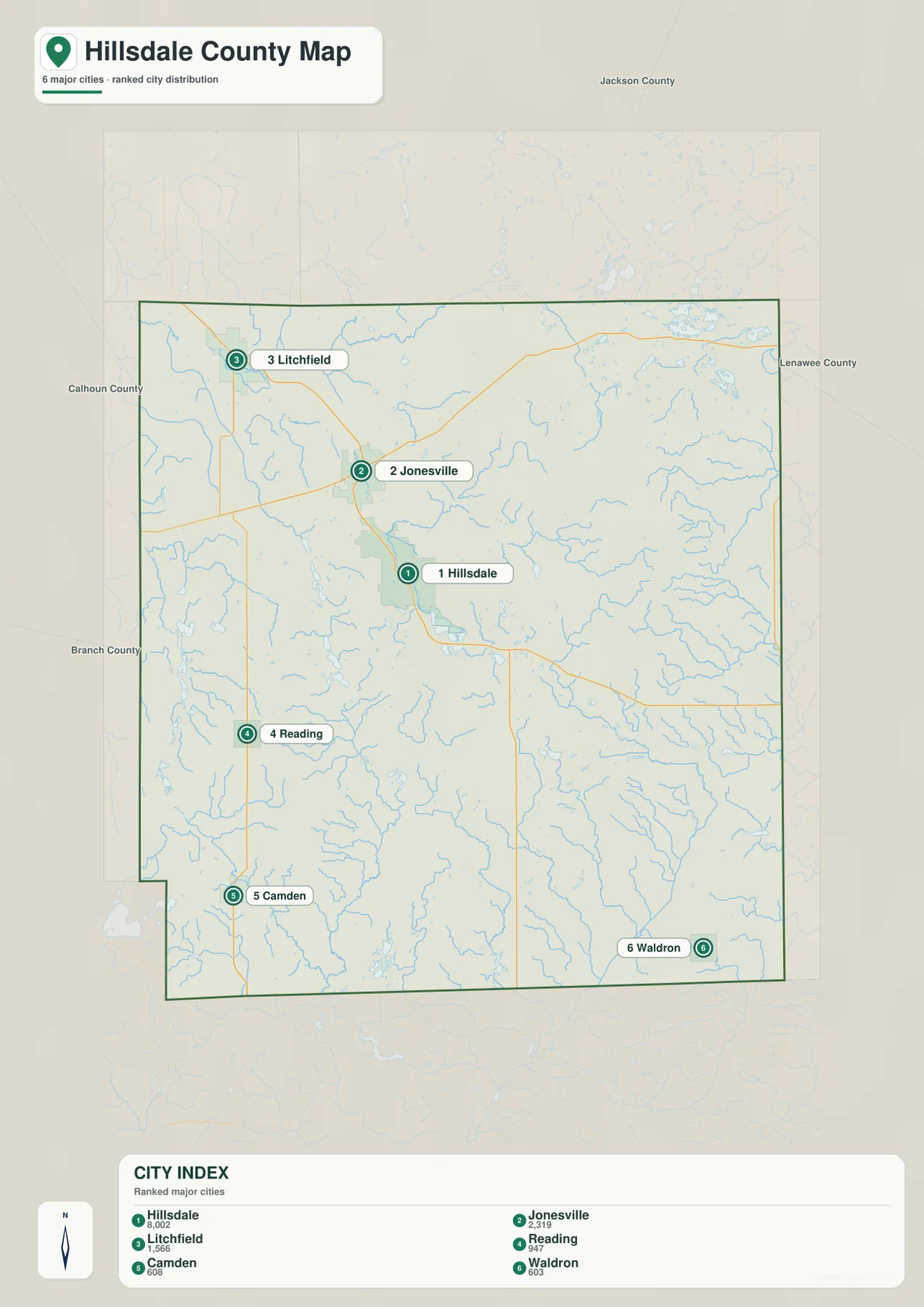
The CITY INDEX lists reference values of 8,002 for Hillsdale, 2,319 for Jonesville, 1,566 for Litchfield, 947 for Reading, 608 for Camden, and 603 for Waldron. These figures are best treated as ranking values used for the map rather than as the latest official population counts. Current population estimates should be checked in the relevant U.S. Census Bureau release.
Hillsdale is the largest highlighted community, with Jonesville forming the next major settlement reference immediately to the north. The general map shows roads, rail, and stream corridors compressed into this central-northern area, which makes it the county’s most connected urban zone.
Litchfield, Reading, and Camden define much of the western side, while Waldron provides the southeastern reference. On the general map, their road relationships differ sharply: the western communities align with US-12 and M-49, while Waldron sits in a lower river landscape closer to the county’s southeastern drainage.
Allen, Pittsford, North Adams, and other labels appear on the general map but are not part of the six-city ranking. The city-distribution view is therefore selective, designed to compare the highlighted communities rather than list every named place.
St. Joseph and Kalamazoo river systems divide a lake-rich county
Hillsdale County has a complex drainage pattern rather than one dominant river. South Branch Kalamazoo River and Kalamazoo River occupy the northern side, while St. Joseph River crosses the central county and continues south. Additional St. Joseph branches and tributaries spread through the southern and southeastern landscape.
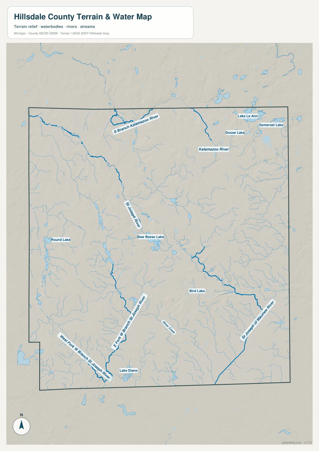
Baw Beese Lake is the most obvious lake reference near the Hillsdale area. St. Joseph River passes through the same central region, with many smaller tributaries joining nearby. The combination of city, lake, and river makes the Hillsdale area especially easy to compare across the general and water maps.
Round Lake appears in the western interior, while West Fork West Branch St. Joseph River and East Fork West Branch St. Joseph River occupy the southwestern side. Around Reading and Camden, numerous small streams create a much denser water pattern than the road map suggests.
St. Joseph of Maumee River is the strongest southeastern river reference, with Silver Creek nearby. Bird Lake lies farther north in the eastern interior, while Lake Diane provides a major southern lake reference. These features help orient the Pittsford and Waldron side of the county.
Lake LeAnn, Somerset Lake, and Goose Lake form a cluster in the northeast. They create a separate lake district from the Baw Beese area and reinforce how varied the county’s inland water geography is. This map is a location reference and does not provide flood, depth, navigation, water-quality, or legal-access information.
Central and northeastern uplands descend toward the southeast
The elevation legend reports an actual range of about 255 to 387 meters with a mean of 323 meters. Dark green marks the lower parts of Hillsdale County, lighter green and yellow indicate intermediate terrain, and orange to brown identifies the higher uplands. The palette is locally scaled, so the same color on another county map should not be assumed to represent the same elevation.
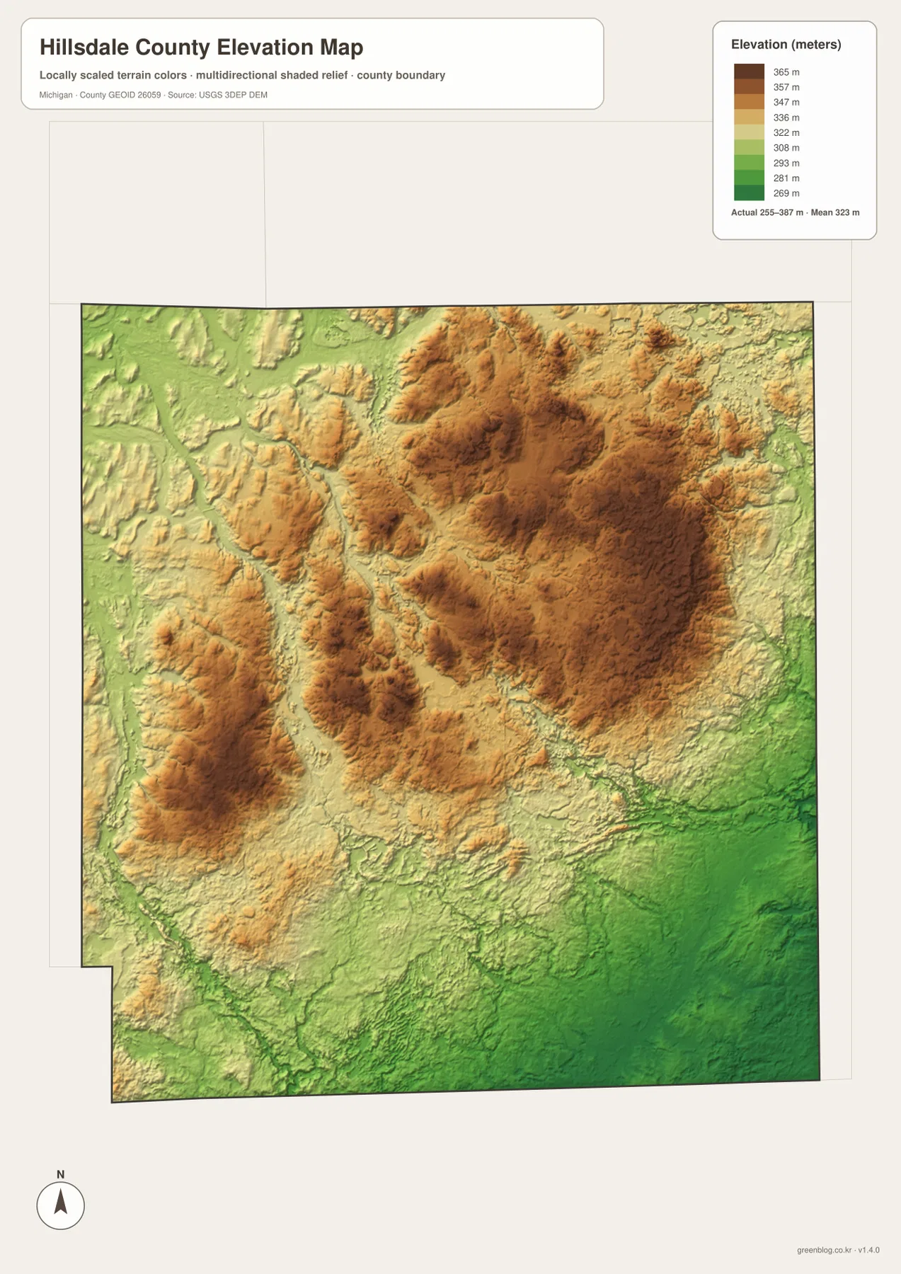
The strongest brown terrain is concentrated across the central-northern and northeastern county. Rather than one continuous high plateau, the map shows clusters of ridges separated by narrow valleys. This is especially visible north and east of Hillsdale, where the terrain is clearly more rolling than a flat agricultural plain.
Western and northwestern Hillsdale County contain long green valleys between higher ridges. Streams west of Jonesville and around Litchfield occupy these lower corridors, while the South Branch Kalamazoo River system follows lower ground across the northern side.
South of Hillsdale, intermediate hills are mixed with lower stream corridors. Baw Beese Lake and St. Joseph River occupy local low areas, while short orange ridges remain nearby. This central-southern zone forms a transition between the higher interior and the broad southeastern lowlands.
The southeast contains some of the largest dark-green areas on the map. St. Joseph of Maumee River and Silver Creek follow low terrain toward the Waldron side, producing a clear contrast with the central and northeastern uplands. This county-scale surface is useful for broad comparison but is not survey-grade or engineering-grade measurement.
Hillsdale, Jonesville, the southwest, and the southeast show distinct settings
Hillsdale is the best place to compare all four maps. M-34 and M-99 provide road references, Baw Beese Lake and St. Joseph River define the local water setting, and the elevation map shows the city near the transition between higher interior hills and lower southern drainage.
Jonesville lies on the US-12 corridor north of Hillsdale. The nearby stream network links the area toward the South Branch Kalamazoo River, while local ridges and valleys make the terrain more varied than the city map alone suggests.
Reading and Camden represent the southwestern rural county. M-49 provides the main road reference, Round Lake and St. Joseph tributaries supply water landmarks, and the elevation surface shows alternating ridges and valleys rather than the broader lowland visible farther southeast.
Pittsford and Waldron represent the eastern and southeastern county. M-34 helps locate the Pittsford side, while St. Joseph of Maumee River and several tributaries organize the lower landscape toward Waldron. The water and elevation maps make this region’s low terrain especially clear.
For practical use, the general map is best for roads and named places, the city map for relative settlement positions, the water map for the St. Joseph and Kalamazoo systems and inland lakes, and the elevation map for the central-upland to southeastern-lowland contrast. Used together, the maps provide a fuller picture of Hillsdale County.
Choosing a Hillsdale County map and using the high-resolution files
Use the general county map when you need Hillsdale, Jonesville, Litchfield, Reading, Camden, Waldron, US-12, M-34, M-49, and M-99 in one view. The city-distribution map is cleaner when the main question is where the six highlighted communities sit within the county. Choose the terrain-and-water map for St. Joseph River, Kalamazoo River, Baw Beese Lake, and Lake Diane, and the elevation map when the contrast between central uplands and southeastern lowlands is the main subject.
The WebP images on this page are optimized for browser viewing. The ZIP below contains the original high-resolution JPG versions of the general county map, city-distribution map, terrain-and-water map, and elevation map. Those originals are better suited to printing, classroom handouts, presentations, and large displays where additional image detail is useful.
Frequently Asked Questions
Which map is best for finding Hillsdale, Jonesville, and Litchfield together?
Use the general county map. It shows US-12 through the Jonesville–Allen side, M-34 and M-99 around Hillsdale, and the road network extending northwest toward Litchfield. The city-distribution map is also useful when you only need relative settlement positions.
Which map shows St. Joseph River and Baw Beese Lake?
Use the terrain-and-water map. It shows St. Joseph River, multiple western branches, St. Joseph of Maumee River, South Branch Kalamazoo River, Baw Beese Lake, Round Lake, Bird Lake, and Lake Diane. It is a location reference and does not provide flood, depth, navigation, water-quality, or access information.
Where does Hillsdale County appear highest on the elevation map?
The broadest high terrain is concentrated across the central-northern and northeastern county, while the southeastern river country is generally lower. The legend reports an actual range of roughly 255 to 387 meters with a mean of 323 meters, but exact site elevations should be checked in authoritative elevation data.
Map File Information
The ZIP contains the high-resolution JPG originals for the Hillsdale County general map, city-distribution map, terrain-and-water map, and elevation map.
- Included Files: general county map, city-distribution map, terrain-and-water map, elevation map
- File Type: JPG
Related Maps
Sources and reference links
For county government and local information, see the official Hillsdale County website and the county’s history page. For boundary and road-reference data, consult U.S. Census Bureau TIGER/Line. Water features can be cross-checked with USGS National Hydrography, and elevation data with the USGS 3D Elevation Program. These page maps are general reference products and do not replace legal boundaries, surveys, navigation charts, or flood determinations.
Green Map creates custom-edited map images using open geographic data sources such as geoBoundaries, Natural Earth, OpenStreetMap, and government open data. These maps are edited visual materials, not raw data files, and are provided for education, documents, presentations, and graphic reference.