Norfolk County is an unusual county to read from a map because its territory is not shown as one continuous shape. The main body stretches from the Boston-side communities of Quincy, Braintree, Randolph, Dedham, and Norwood toward Franklin and Bellingham in the southwest, while Brookline appears as a detached northern section and Cohasset appears separately on the eastern side. That broken outline is one of the most important things to notice before comparing roads, cities, or waterways. High-resolution map files are available for download in the section below.
This page brings together three map references: a general county map with major roads and selected places, a ranked five-city distribution map, and a terrain-and-water map showing rivers, smaller streams, shaded relief, and nearby coastal waters. The original high-resolution JPG files represented by these maps can be downloaded together in a ZIP archive. They work well for regional orientation, printing, classroom use, and presentations, but they are not substitutes for live navigation, legal parcel mapping, flood-zone products, or survey-grade elevation data.
Table of Contents
Detached county sections make Route 1, Route 24, I-95, and I-495 especially useful references
The general map gives the clearest explanation of Norfolk County’s shape. Its main body reaches from Wellesley and Needham in the northwest through Dedham and Norwood, then spreads east across Milton, Quincy, Braintree, Weymouth, Randolph, and Holbrook. The southwest extends toward Franklin and Bellingham. Brookline, however, is drawn above the main county body as a separate section close to Boston, and Cohasset is shown as another detached section farther east near the coast. A reader who looks only at the largest polygon will therefore miss part of the county.
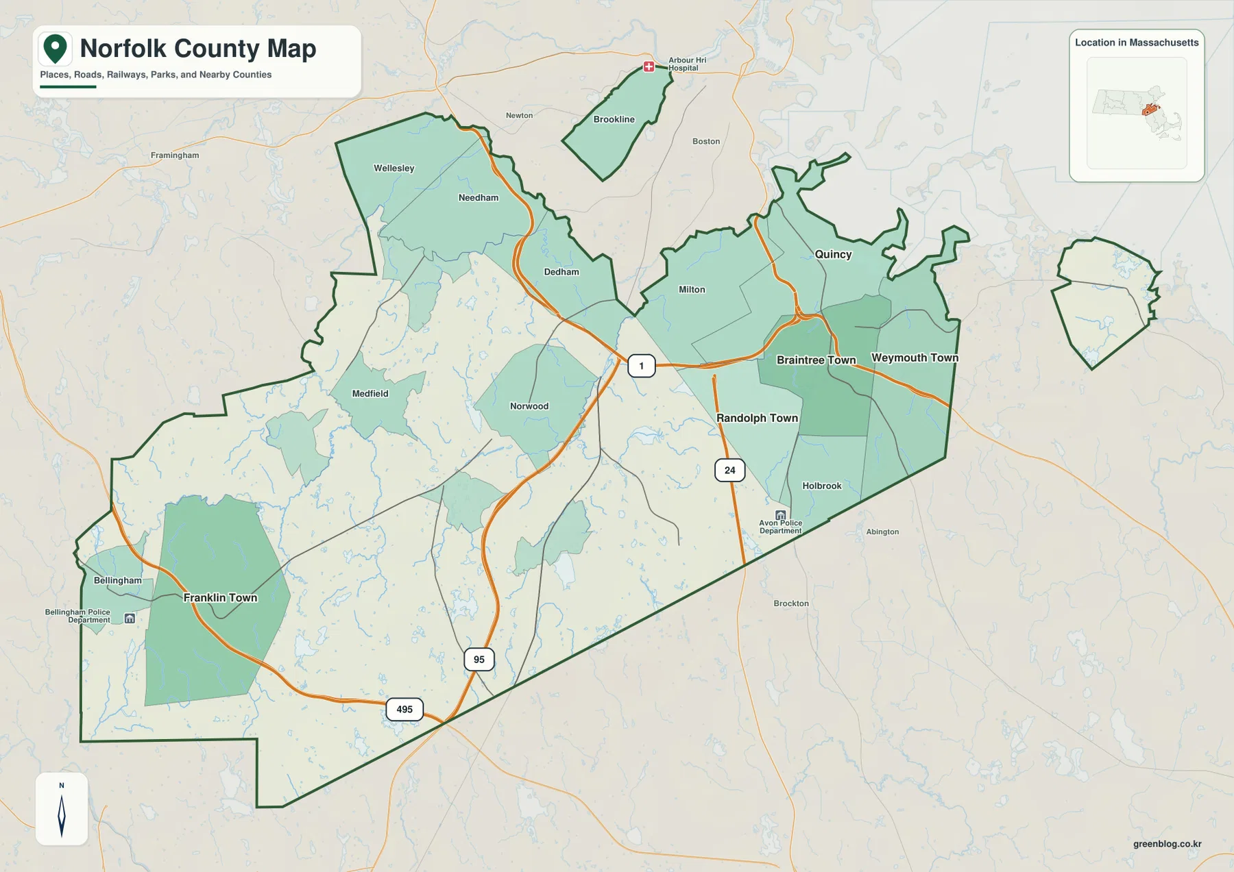
Route 1 is a useful central reference because it crosses the part of the county where Dedham and Norwood sit between the Boston-side communities and the broader interior. It helps organize a map that otherwise contains many short local connections. Route 24 is farther east and runs through the Randolph-Holbrook side of the county. Together, those two numbered routes make it easier to separate the central and eastern portions rather than treating all of southern Greater Boston as one compact urban area.
I-95 is the stronger north-south reference on the central-western side. On the map it approaches the Route 1 area and then continues south, while I-495 lies much farther out near Franklin and Bellingham. The difference between those interstate positions is useful because Norfolk County changes character across that distance. Quincy, Braintree, Weymouth, and Randolph occupy a denser eastern setting, whereas the southwest around Franklin and Bellingham has more open map space between major labels and sits much farther from the Boston Harbor side.
Dedham and Norwood are practical middle reference points. Wellesley and Needham lie to the north and northwest, Milton and Quincy are farther east, and Randolph and Holbrook sit to the southeast. The county outline bends around this central area, and smaller water bodies appear throughout the map. Because of that combination, a single road cannot explain the entire county. The general map is most useful when the road network, municipal names, and county outline are viewed together.
The eastern edge is particularly important for orientation. Quincy is close to the Boston Harbor side, Braintree and Weymouth continue south and southeast from it, and Randolph lies inland. This cluster is visually very different from Franklin, which appears near the opposite southwestern side of the county. A presentation that begins with Quincy and then jumps directly to Franklin can show the county’s broad extent quickly, while Dedham and Norwood provide the middle reference points needed to make that comparison understandable.
The detached sections deserve separate attention because they can disappear when the map is reduced for a slide or printed small. Brookline is not attached to the main Norfolk County body on this map, even though it remains part of the county. Cohasset is also drawn separately to the east. These pieces are useful examples of why a county map should not be interpreted from one large boundary shape alone. For legal boundary questions, of course, an official boundary dataset or local assessor source should be used rather than a generalized reference map.
Five ranked cities show an eastern cluster and a separate southwestern center
The city-distribution map removes most road and place-name detail and highlights five ranked locations. Quincy is marked 1, Weymouth Town 2, Braintree Town 3, Randolph Town 4, and Franklin Town 5. The strongest visual pattern is the concentration of four ranked places in the east. Quincy, Weymouth, Braintree, and Randolph sit relatively close together, while Franklin is positioned far to the southwest. This makes the map especially useful for explaining how the county’s larger population centers are distributed rather than simply listing their names.
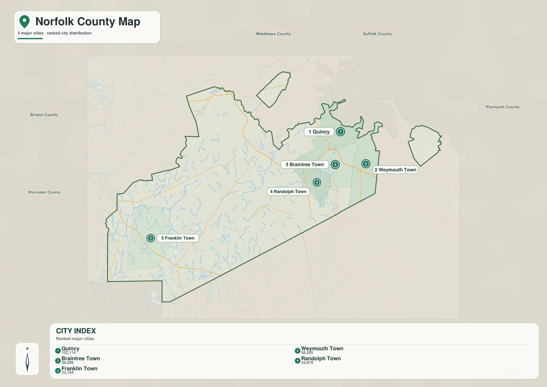
The CITY INDEX prints values of 102,114 for Quincy, 58,505 for Weymouth Town, 38,899 for Braintree Town, 34,878 for Randolph Town, and 33,154 for Franklin Town. Those figures should be treated as values from the dataset used to create this particular graphic, not as a guarantee that they are the newest official population estimates. Population totals change as new estimates and census products are released. When an exact current figure matters, the U.S. Census Bureau should be checked separately.
Quincy is the northernmost of the tightly grouped eastern cities and is closest to the coastal side of the county. Weymouth and Braintree sit immediately south and southeast, while Randolph is somewhat farther inland. Returning to the general map adds the missing transportation context: Route 24 runs through this broader eastern side, and other local roads connect the communities in ways the simplified city graphic intentionally leaves out. That difference is helpful when deciding which map to use for a presentation.
Franklin creates the main contrast. It is not part of the tight Quincy-Weymouth-Braintree-Randolph grouping and instead anchors the southwestern portion of the map. I-495 appears near Franklin on the general map, giving that area a different road reference from the eastern side. The distance on the city graphic is not a travel-time measurement, but it makes the county’s scale much easier to grasp. Norfolk County includes both Boston-adjacent communities and a substantial inland southwest.
The ranked map is deliberately selective. Dedham, Norwood, Milton, Wellesley, Needham, Walpole, Canton, Foxborough, Brookline, Cohasset, and other communities visible on the general map are not included in the five-city list. That does not make them unimportant; it simply means the graphic is designed around a limited ranking. It should therefore be labeled as a selected major-city distribution map rather than a complete map of every municipality in Norfolk County.
The two map types answer different questions. The general map is better when someone needs to understand the county boundary, road references, or the detached sections. The city map is better when the goal is to show how several large population centers are positioned relative to one another without the distraction of smaller roads and place labels. Using both together avoids the common mistake of treating the five highlighted cities as the entire county.
Charles and Neponset waterways meet a county that also reaches Boston Harbor and the Blue Hills
The terrain-and-water map changes the emphasis completely. Charles River is labeled across the northwestern and northern side, while Neponset River runs through the central-northeastern part of the county toward the Boston Harbor side. In the east, Weymouth Fore River and Monatiquot River appear near the Braintree-Weymouth area. Mill River and Stop River are labeled in the southwest. Outside and beside the county edge, Boston Harbor, Dorchester Bay, Hingham Bay, Nantasket Roads, Massachusetts Bay, and the Atlantic Ocean provide the coastal setting.
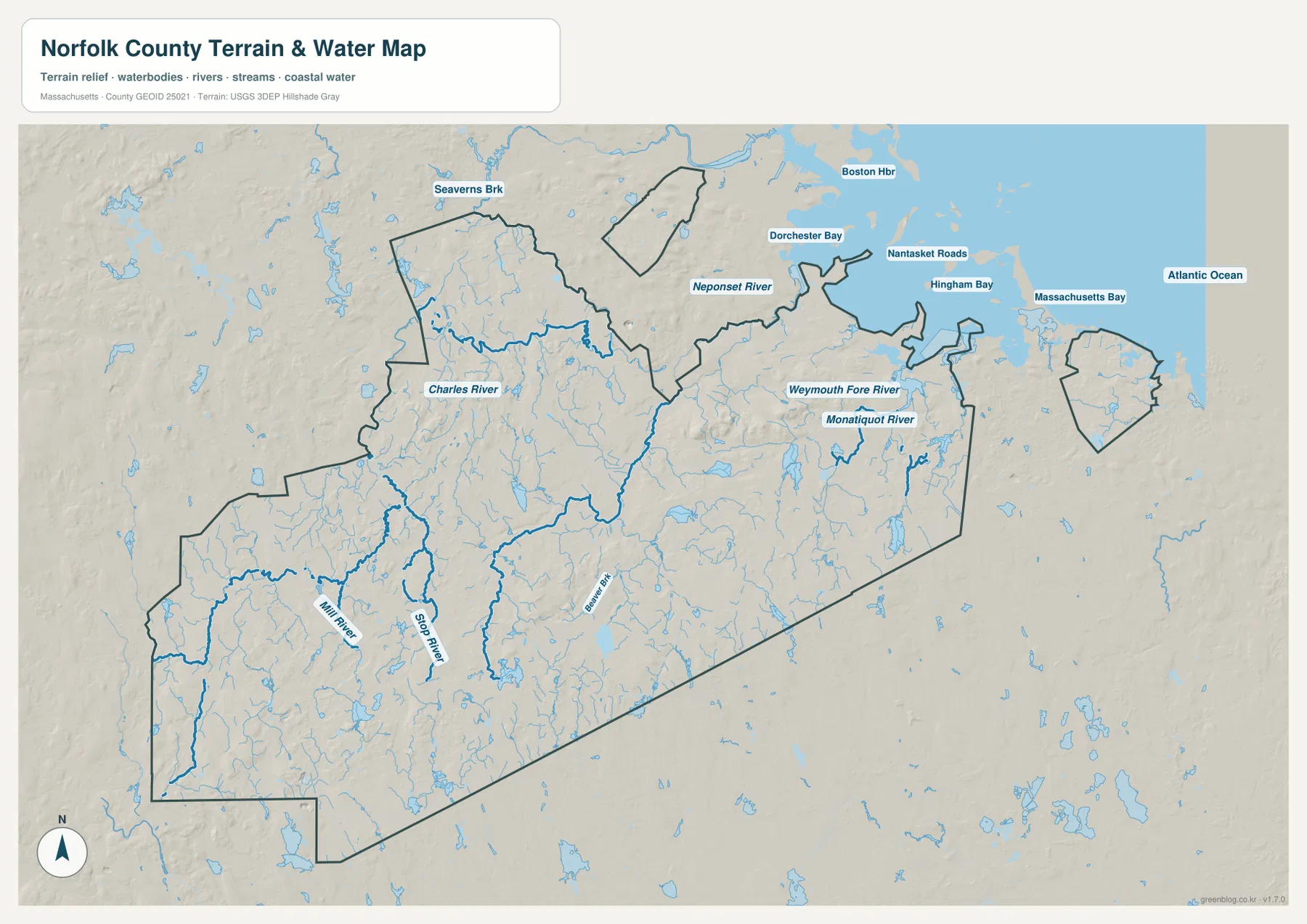
Charles River is the best water reference for the northwestern side. When Wellesley, Needham, and Dedham are located on the general map first, the water map makes it easier to see how that part of Norfolk County relates to the Charles system and its smaller tributaries. Massachusetts DCR’s Cutler Park Reservation in Needham protects a large freshwater marsh on the middle Charles River, which is a useful reminder that the northwestern side of the county contains wetlands and river landscapes as well as suburban roads and neighborhoods.
Neponset River is more important for the northeastern interior. It runs toward the Milton side and ultimately the Boston Harbor setting shown beyond the county boundary. On this map the river is a geographic reference, not a flood forecast. The blue lines do not encode depth, discharge, water quality, or regulatory limits. Anyone evaluating flood exposure, wetlands permitting, or property-specific conditions should use the appropriate current state or federal datasets rather than treating this reference map as a hazard product.
The Quincy-Braintree-Weymouth side has the most obvious coastal relationship. Weymouth Fore River and Monatiquot River are labeled within the eastern drainage pattern, and the map also names Hingham Bay and Nantasket Roads outside the county edge. That makes the difference between eastern and southwestern Norfolk County much easier to explain. The east is closely tied to harbor and coastal waters, while the Franklin-Bellingham side is defined more by inland streams, ponds, and river branches.
Shaded relief around Milton, Quincy, Randolph, and nearby communities also stands out from the flatter-looking areas farther west. This is the Blue Hills area. The Massachusetts Department of Conservation & Recreation describes Blue Hills Reservation as extending over more than 7,000 acres from Quincy to Dedham and Milton to Randolph, with Great Blue Hill rising to 635 feet. The map on this page does not provide survey-grade elevations, but that official geographic context helps explain why the northeastern part of the county has a more pronounced hilly appearance.
The southwest has a different visual rhythm. Mill River and Stop River are labeled there, and numerous smaller ponds and streams are scattered through the Franklin-Bellingham side and adjacent interior. The coastline is absent, and the relief is less dominated by the compact Blue Hills pattern. Comparing this view with the general map shows why Norfolk County cannot be summarized as only a Boston suburban county: the county includes coastal, hilly, riverine, and inland settings within one administrative area.
Coastal labels should be read as surrounding geographic context, not as a statement that every blue area belongs within Norfolk County. Boston Harbor, Massachusetts Bay, and the Atlantic Ocean extend far beyond the county. Likewise, a line labeled as a river should not be used to determine channel width or legal waterfront boundaries. The purpose of the map is regional orientation: where the major named waters lie, how the east differs from the southwest, and where shaded terrain becomes more noticeable.
Choose the county map according to the question you need to answer
Start with the general county map when the first question is about shape, roads, or municipal position. It is the only one of the three that makes the detached Brookline and Cohasset sections immediately obvious while also showing Route 1, Route 24, I-95, and I-495. A useful reading sequence is to begin at Quincy, move through Braintree and Randolph toward Dedham and Norwood, then continue southwest toward Franklin. That path shows the county’s broad extent without implying that all of those places are connected by one road.
Use the ranked city map when clarity matters more than completeness. It quickly shows that Quincy, Weymouth, Braintree, and Randolph form an eastern concentration and that Franklin occupies a separate southwestern position. Because most road detail is removed, the graphic works well on a slide or in a simple regional comparison. It should be paired with the general map if the audience also needs Dedham, Norwood, Wellesley, Milton, Brookline, Cohasset, or other communities that are not part of the five-city ranking.
The terrain-and-water map is the best choice for rivers, coastal context, and the relative difference between the Blue Hills side and the inland southwest. Charles River and Neponset River organize the northern and central areas, while Weymouth Fore River and Monatiquot River help explain the eastern drainage near the coast. Mill River and Stop River provide southwestern references. The shaded relief is useful for broad terrain comparison, but a precise elevation, slope, flood, or engineering question requires a dedicated official dataset.
For printing, the original JPGs in the download archive are preferable to the smaller web images embedded in the article. Each file has a different job: the general map combines boundaries, roads, and selected place names; the city graphic simplifies the county to five ranked centers; and the terrain-and-water map emphasizes rivers, smaller waters, coast, and relief. Choosing one according to the audience usually produces a clearer result than trying to put every layer into a single image.
All three maps are regional references rather than real-time operational products. Road lines do not report closures or congestion. The city-index values belong to the dataset used for the graphic and may not match the newest official estimates. The water map does not show flood zones, navigation channels, or legal waterfront boundaries. Within those limits, the set is useful because it explains several features that are easy to miss: the county’s detached sections, the separation between Quincy and Franklin, and the contrast between coastal waterways and the inland river network.
Frequently Asked Questions
Why do Brookline and Cohasset appear detached from the main Norfolk County area?
On the supplied general map, Brookline appears as a separate northern section and Cohasset as a separate eastern section, while the largest county body extends from the Quincy-Dedham area toward Franklin and Bellingham. All of those sections belong to Norfolk County. The detached pieces are easy to miss on a small map, so they should be included whenever the county’s full outline is being explained.
Are the city-index values such as Quincy 102,114 the latest population totals?
They should not be treated as guaranteed current totals. The values are printed on the supplied city-distribution graphic and reflect the dataset used to make that map. Official population estimates change over time. Use the numbers for the map’s ranking and relative comparison, and consult the U.S. Census Bureau when a current official figure is required.
Can the terrain-and-water map be used to identify flood zones along the Neponset River or Quincy coast?
No. The map shows the approximate regional position of rivers, streams, coastal waters, and shaded terrain. It does not map flood probabilities, regulatory floodplains, expected water depths, or property-specific risk. For flood planning or insurance questions, use current FEMA and Massachusetts hazard information rather than this general reference map.
Map File Information
The ZIP contains the original high-resolution JPG files for the Norfolk County general map, ranked five-city distribution map, and terrain-and-water reference map described on this page.
- Included Files: general county map, major-city distribution map, terrain-and-water reference map
- File Type: JPG
Related Maps
Sources and References
These official sources are useful for checking boundary data, hydrography, and local terrain or park context related to Norfolk County.
- U.S. Census Bureau – TIGER/Line Shapefiles
- USGS – National Hydrography
- Mass.gov – Blue Hills Reservation
- Mass.gov – Cutler Park Reservation
Green Map creates custom-edited map images using open geographic data sources such as geoBoundaries, Natural Earth, OpenStreetMap, and government open data. These maps are edited visual materials, not raw data files, and are provided for education, documents, presentations, and graphic reference.