Harford County occupies Maryland’s northeastern transition from rolling inland uplands to the Susquehanna River and upper Chesapeake shoreline. Bel Air anchors the central county, Aberdeen and Havre de Grace form the strongest incorporated-city corridor in the east, and communities such as Fallston, Jarrettsville, Pylesville, Edgewood, and Joppatowne spread across very different terrain. The maps on this page explain the major roads, city connections, creeks and rivers, and elevation differences across the county. Matching high-resolution JPG files can also be downloaded together in a ZIP archive. High-resolution map files are available for download in the section below.
Harford County Government identifies three municipalities within the county: Aberdeen, Bel Air, and Havre de Grace. County history material places the county seat in downtown Bel Air. Those three incorporated places are only part of the settlement picture, however; the general map also shows large unincorporated communities and named areas that help explain how the county functions between the northern countryside and the I-95-Chesapeake side.
Table of Contents
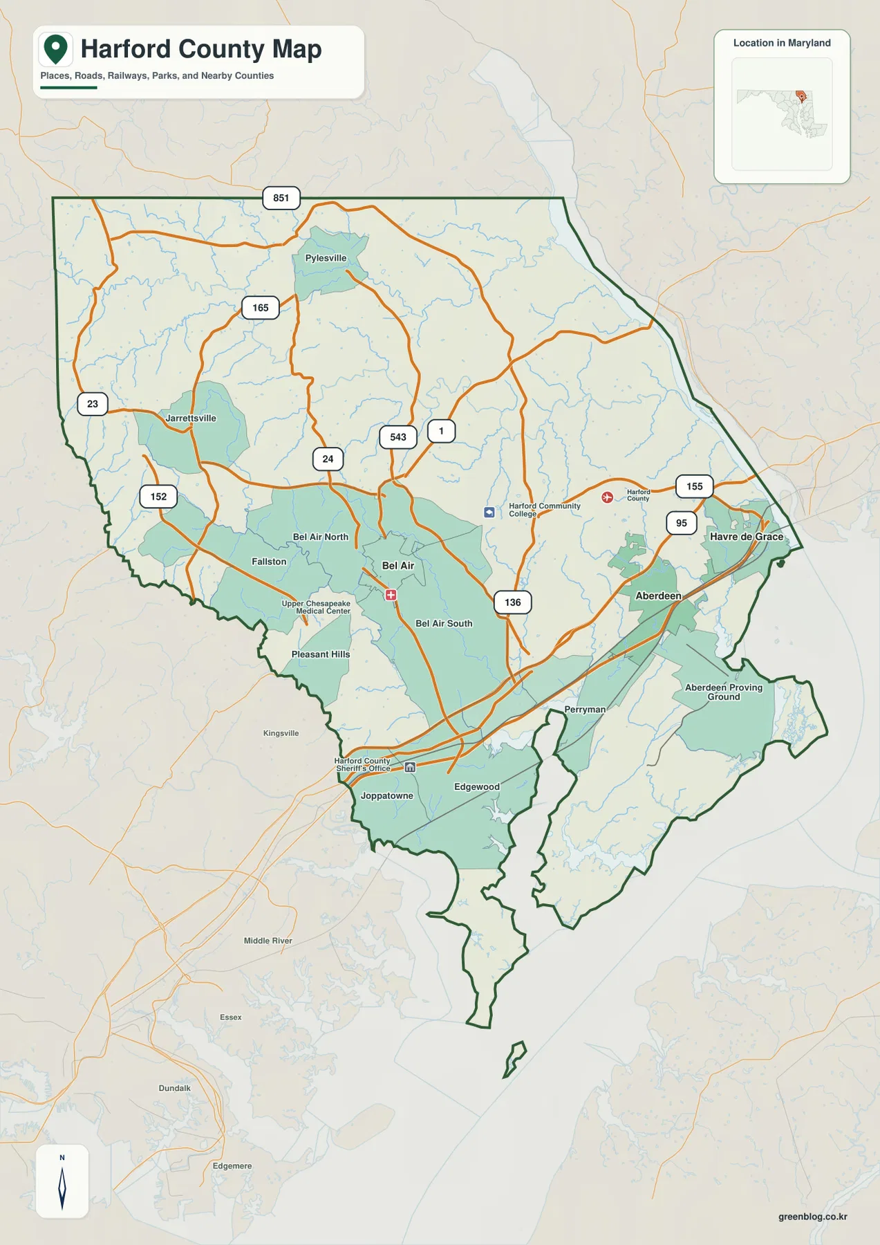
Bel Air provides the central reference between Fallston, Jarrettsville, and the Aberdeen side
Bel Air is the clearest starting point on the general county map. Bel Air North and Bel Air South sit immediately around it, with Fallston and Pleasant Hills to the west and Jarrettsville farther northwest. MD 24 passes through the Bel Air area, while MD 543 and U.S. 1 connect the center with eastern and southeastern parts of the county.
Pylesville appears north of Jarrettsville, with MD 165 providing a strong road reference through the northern interior. MD 23 crosses the western side, and MD 152 is useful around the Fallston corridor. Compared with the southern waterfront, the north contains fewer dense settlement labels and many more small streams, giving it a distinctly rural and rolling character.
East of Bel Air, the map labels Harford Community College and county facilities before the road network reaches Aberdeen and Havre de Grace. Aberdeen forms a major transportation and employment area in the southeast, while Havre de Grace occupies the Susquehanna-Chesapeake side farther northeast. The two cities appear close together, but broad water and the river mouth strongly shape the local geography.
Edgewood, Joppatowne, and Perryman line the southern part of the county, and Aberdeen Proving Ground occupies a large southeastern area. This section has a much stronger coastal influence than the northern uplands. The contrast between stream-cut hills in the northwest and low tidal terrain in the south is one of the most distinctive features of the county map.
I-95 and MD 24, 543, and 155 serve different sides of the county
I-95 is the strongest transportation reference across southeastern Harford County. It passes through the Edgewood-Aberdeen side and continues toward Havre de Grace and the Susquehanna crossing. Unlike the state roads that primarily connect local communities, I-95 is a regional interstate corridor and strongly shapes the southern transportation pattern.
Around Bel Air, MD 24 and MD 543 are especially useful. MD 24 links the central county with northern areas, while MD 543 runs toward U.S. 1 and the I-95 side. U.S. 1 provides another important link between the central and eastern county and makes the Bel Air-Aberdeen relationship easier to follow.
MD 155 becomes prominent near Havre de Grace and the Susquehanna side. Aberdeen is also connected by MD 136 and the broader network around the interstate corridor. For quick orientation, use MD 24 and 543 around Bel Air, then switch to I-95, U.S. 1, and MD 155 when reading the Aberdeen-Havre de Grace side.
The map is not a live traffic product. Construction, congestion, incidents, and closures can change on I-95 and the state highways. Actual trips should be checked with current Maryland transportation information and a navigation service; the county map is best for relative location and corridor orientation.
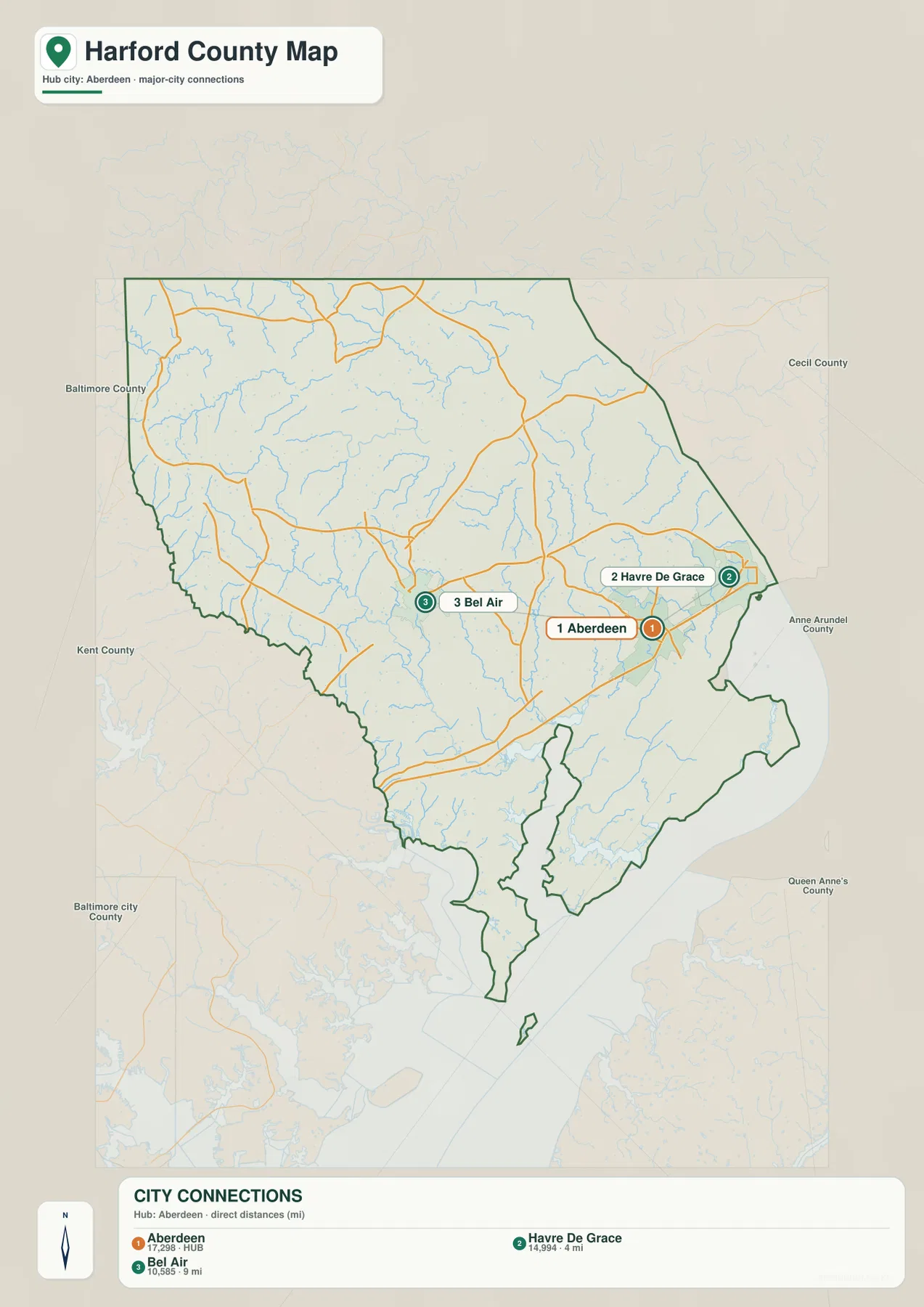
The Aberdeen hub graphic gives straight-line distances to Havre de Grace and Bel Air
The City Connections graphic uses Aberdeen as the hub and connects it with Havre de Grace and Bel Air. It prints the values 17,298 for Aberdeen, 14,994 for Havre de Grace, and 10,585 for Bel Air. Because no reference year or statistical definition is shown, those figures should not be presented as current population counts. Current figures should come from the latest U.S. Census Bureau or municipal data.
The distance labels are explicitly described as direct distances. Havre de Grace is shown 4 miles from Aberdeen and Bel Air 9 miles away. These are straight-line measurements rather than road mileage. Actual driving follows I-95, U.S. 40, MD 22, MD 155, and other local roads, so the route distance and travel time can be different.
The three markers also happen to represent Harford County’s three incorporated municipalities. Aberdeen lies in the southeast, Havre de Grace is northeast near the Susquehanna River, and Bel Air is farther west in the interior. Important unincorporated communities such as Edgewood, Fallston, and Jarrettsville do not appear on this simplified graphic, so the full county map remains necessary for a broader settlement view.
City Connections is most useful for quick direction and distance context. It removes most of the local road detail and leaves the relationship among the three municipalities easy to see. For commuting, current traffic, or exact mileage, use the road map and a current routing service instead.
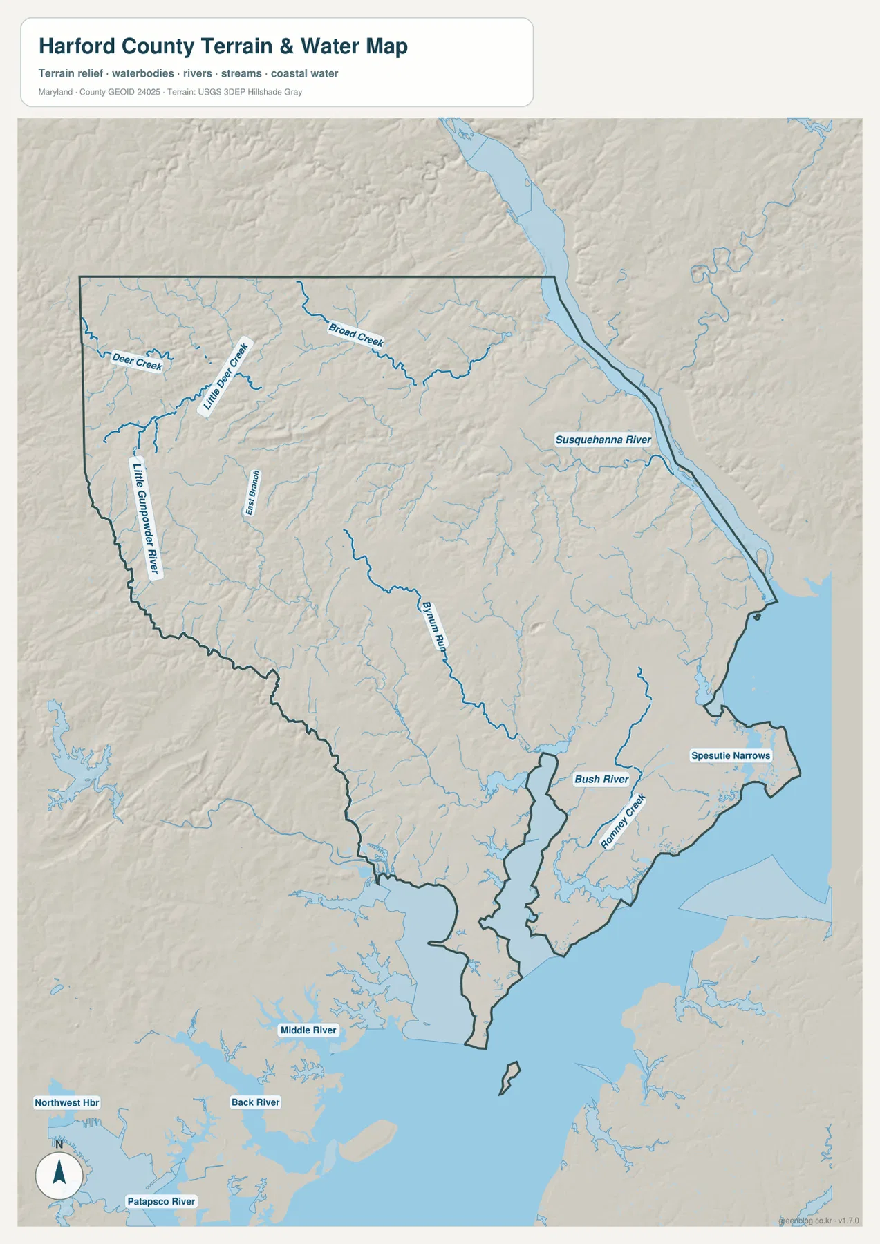
Deer Creek and Bynum Run drain the interior before larger rivers open toward Chesapeake Bay
Deer Creek and Little Deer Creek are among the clearest water labels in the northwest, with Broad Creek crossing the northern interior. Little Gunpowder River follows part of the western side near the Baltimore County boundary. These streams occupy relatively narrow valleys through the rolling uplands and make the northern terrain look much more dissected than the low coastal plain.
Bynum Run is a strong central water reference, with East Branch entering from the northwest. Around Bel Air, smaller streams rather than one large river divide the landscape. Harford County’s own seal history highlights Deer Creek, Bynum Run, and Winters Run as three major county streams, showing that the interior drainage has long been part of the county’s geographic identity.
Susquehanna River dominates the eastern edge and widens dramatically near Havre de Grace before opening into Chesapeake Bay. Maryland DNR describes Susquehanna State Park as a forested, rocky river-valley landscape in Harford County, with a separate Deer Creek picnic area. That official park setting gives useful local context for the steep river terrain visible on the water map.
Bush River, Romney Creek, and Spesutie Narrows shape the southeastern shoreline around Aberdeen Proving Ground. These waterways create a very different setting from the inland creeks to the north. The map is a geographic reference, not a nautical chart, flood map, depth source, or legal water-boundary product; those uses require current NOAA, FEMA, USGS, Maryland DNR, or local information.
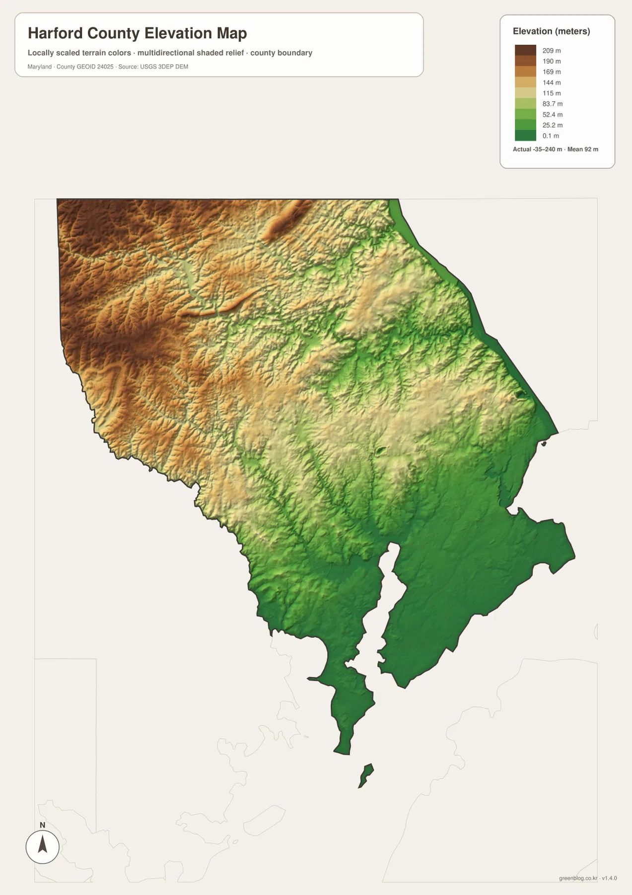
Elevation falls from the northwestern uplands toward the Susquehanna and Chesapeake lowlands
The elevation graphic prints an actual data range from -35 to 240 meters and a mean elevation of 92 meters. Those values describe the range in the supplied dataset and should not be treated as parcel-level survey elevations. The visual pattern is clear: higher brown and tan terrain dominates the northwest, while lower green land expands toward the Susquehanna River and the southern Chesapeake-facing areas.
The Jarrettsville-Pylesville side contains repeated ridges separated by Deer Creek, Little Deer Creek, and other narrow valleys. Lower green corridors follow the streams while higher ground remains between them. Elevation decreases toward Bel Air and drops much more strongly toward Aberdeen, Havre de Grace, Edgewood, and the tidal shoreline.
The southeast is broadly low, especially around Bush River, Spesutie Narrows, and the Chesapeake-facing parts of Aberdeen Proving Ground. Harford County therefore spans a strong transition from Piedmont-style rolling uplands to Coastal Plain lowlands. The terrain map makes that regional change much easier to see than the road map alone.
The -35 to 240 meter range should not be used as the exact elevation of a road, house, or parcel. Engineering, surveying, drainage design, and flood-risk work require authoritative USGS elevation data, professional survey measurements, and dedicated FEMA or local flood products. Elevation color alone cannot determine actual flood exposure.
Use the Bel Air road view for communities and the eastern maps for river-valley and coastal context
The general county map is the best starting point for Bel Air, Aberdeen, Havre de Grace, Fallston, Edgewood, I-95, U.S. 1, MD 24, and MD 543. The City Connections view is cleaner when the only question is how Aberdeen relates to Havre de Grace and Bel Air by straight-line distance. For natural geography, the terrain-water map highlights Deer Creek, Bynum Run, Susquehanna River, and Bush River, while the elevation view explains the transition from high northwestern terrain to low coastal land.
Susquehanna State Park provides a useful local example of that terrain change. Maryland DNR places the park along the Susquehanna River valley and describes forest cover, rocky terrain, and river-based recreation. Comparing the park’s location with the county map makes it clear that the eastern border is not merely a flat river edge; the valley has substantial local relief before the river reaches Havre de Grace and Chesapeake Bay.
The downloadable originals are JPG files measuring 2572 × 3638 pixels each. They can be used in full-page documents or enlarged around Bel Air, Aberdeen, Havre de Grace, Deer Creek, or other areas for classroom material, presentations, and personal reference. Enlargement does not add live traffic, parcel boundaries, flood zones, water depth, or survey-grade elevation, so specialized decisions should always use current official data.
Frequently Asked Questions
What is the county seat of Harford County, Maryland?
Bel Air is the county seat. Harford County’s official history page places the county seat in downtown Bel Air, and the general map shows it as the central reference among Bel Air North, Bel Air South, Fallston, and the main state-road network.
Are the 4 miles to Havre de Grace and 9 miles to Bel Air driving distances from Aberdeen?
No. The City Connections graphic labels them as direct distances, meaning straight-line measurements. Actual driving follows I-95, U.S. 40, MD 22, MD 155, and other local roads, so road mileage and travel time can differ.
Can the -35 to 240 meter elevation range be used for surveying or flood decisions?
No. It is the overall data range printed on the supplied elevation graphic and is useful only for broad geographic comparison. Precise property elevation should come from authoritative USGS or professional survey data, and flood decisions should rely on current FEMA and local flood information.
Map File Information
The ZIP archive contains high-resolution JPG maps of Harford County matching the map themes described on this page.
- Included Files: county and major roads map, City Connections map, terrain and water map, elevation map
- Printable Size: 2572 × 3638 pixels each
- File Type: JPG
Related Maps
Sources and References
- Harford County Government – Government & Municipalities
- Harford County – History of County Government
- Maryland DNR – Susquehanna State Park
- U.S. Census Bureau – TIGER/Line Shapefiles
- USGS – National Hydrography
- USGS – 3D Elevation Program
Green Map creates custom-edited map images using open geographic data sources such as geoBoundaries, Natural Earth, OpenStreetMap, and government open data. These maps are edited visual materials, not raw data files, and are provided for education, documents, presentations, and graphic reference.