Jefferson Davis Parish sits in southwest Louisiana, where Jennings and Welsh form the most obvious central settlement corridor and U.S. 90 provides the clearest east-west reference. Elton and Fenton lie well to the north, Lake Arthur is separated to the south, and a dense network of bayous, rivers, canals, and drainage channels crosses the parish between them. This page uses the supplied maps to explain those relationships in practical terms, and the matching high-resolution JPG map files are available together as a ZIP download for printing, teaching, presentations, and regional reference.
The official Louisiana parish profile identifies Jennings as the parish seat and lists Welsh, Elton, Lake Arthur, and Fenton among the incorporated communities. The general map adds smaller places such as Lacassine and Roanoke and shows how they fit into the same road network. That combination matters here because Jefferson Davis Parish is not organized around a single compact urban area: its communities are spread from the U.S. 90 corridor to the northern projection and the Mermentau River lowlands in the south.
Table of Contents
U.S. 90 ties together the parish’s central settlement corridor
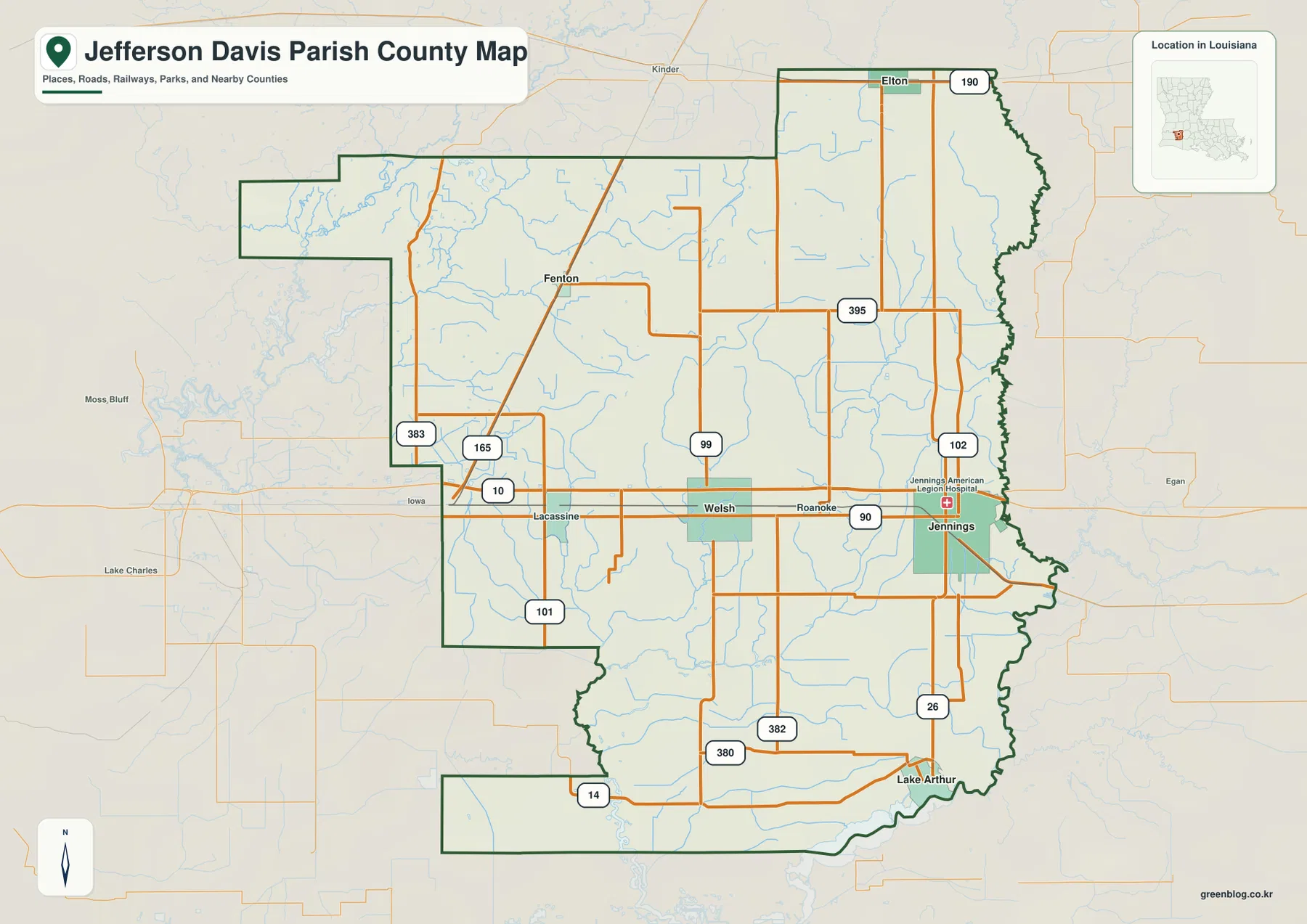
On the general parish map, U.S. 90 is the easiest road to use as an orientation line. It enters from the west near Lacassine, runs through Welsh, passes Roanoke, and reaches Jennings near the eastern side of the parish. Around Jennings, LA 26 and LA 102 provide north-south connections, while the Welsh area has LA 99 and several local routes branching away from the highway. This creates a more concentrated road pattern through the center than in the broad rural areas to the north and south.
The northwestern portion has a different road structure. U.S. 165 passes near Fenton before continuing toward the parish boundary, and LA 383 and LA 10 meet close to the western side. Farther north, Elton occupies the narrow upper projection, with U.S. 190 crossing near town and LA 395 extending southward. Reading the map from U.S. 90 outward makes these separate networks easier to understand: the central highway links the largest mapped communities, while other routes reach the more distant northern settlements.
Lake Arthur and the northern towns sit outside the Jennings–Welsh core
Lake Arthur lies near the southern boundary, separated from the central U.S. 90 corridor by a broad interior of local roads and waterways. LA 26 connects the Jennings area southward, while LA 14, LA 380, and LA 382 appear around the lower part of the parish. The town’s position near the Mermentau River gives the southern edge a very different geographic character from the highway-focused center.
Elton and Fenton are separated in the opposite direction. Fenton is associated with the U.S. 165 corridor in the northwest, whereas Elton occupies the upper projection near U.S. 190. The parish outline itself reinforces this spread: the north is stepped and narrow in places, the east follows a winding edge for long stretches, and the southwest includes another broad extension. As a result, the distance between named communities is an important part of the map rather than a minor detail.
The city-connections view makes straight-line spacing easy to compare
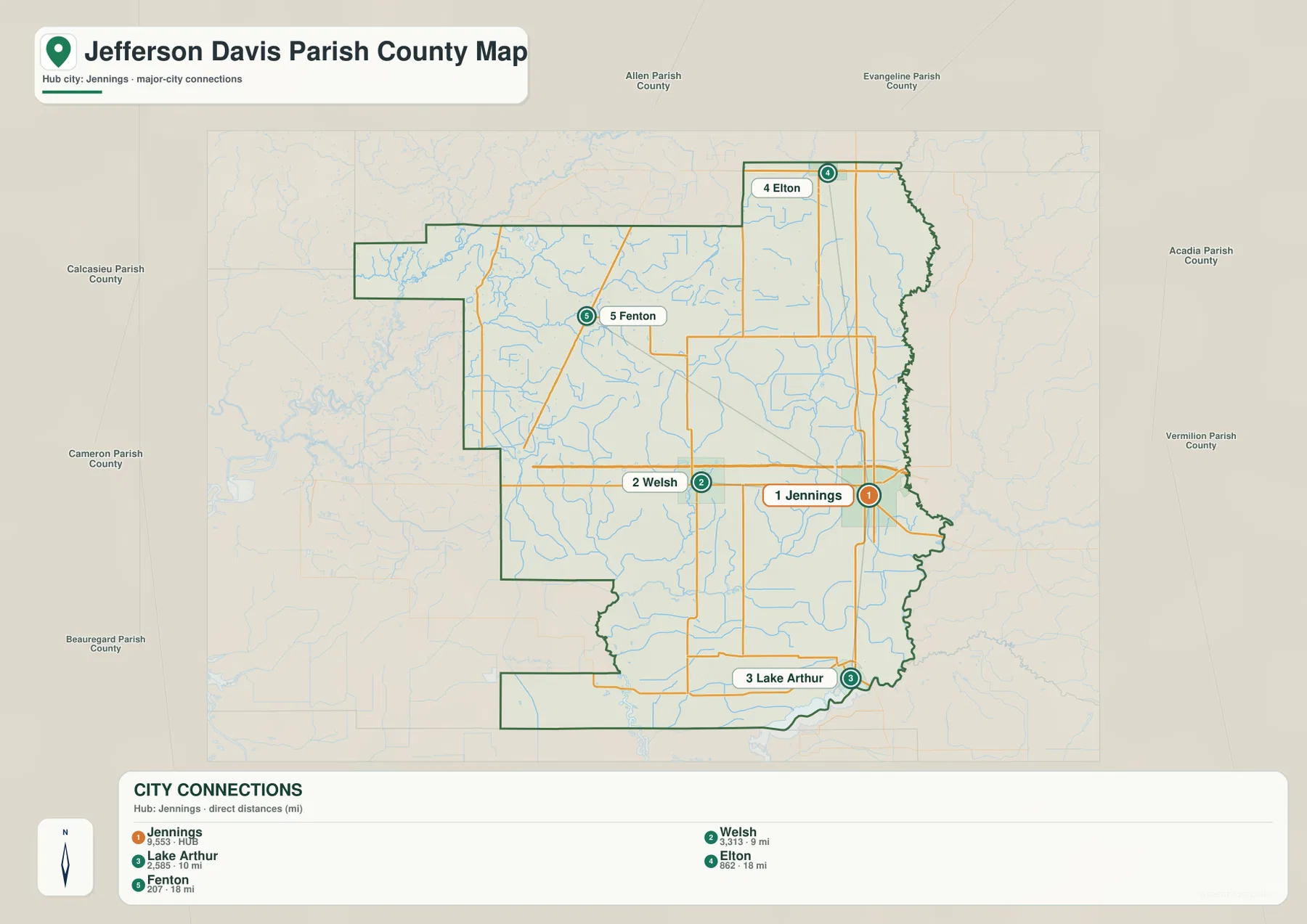
The simplified city map uses Jennings as its hub and strips away much of the road detail. It marks Welsh 9 miles from Jennings, Lake Arthur 10 miles away, and both Elton and Fenton at 18 miles. The map explicitly labels these as direct distances, so they should be read as straight-line measurements rather than driving mileage. Road distance and travel time can differ because actual routes must follow the highway network and available crossings.
This view is especially useful when the question is where the main communities sit relative to one another. Welsh is the closest of the mapped towns to Jennings along the central band, Lake Arthur is distinctly south, Elton is north, and Fenton is northwest. The map also labels surrounding parishes, including Allen, Evangeline, Acadia, Vermilion, Cameron, Calcasieu, and Beauregard, which helps place Jefferson Davis Parish within the wider southwest Louisiana region. Smaller places visible on the general map are intentionally omitted here, so the two maps serve different purposes.
Mermentau River and Bayou Lacassine dominate the eastern drainage pattern
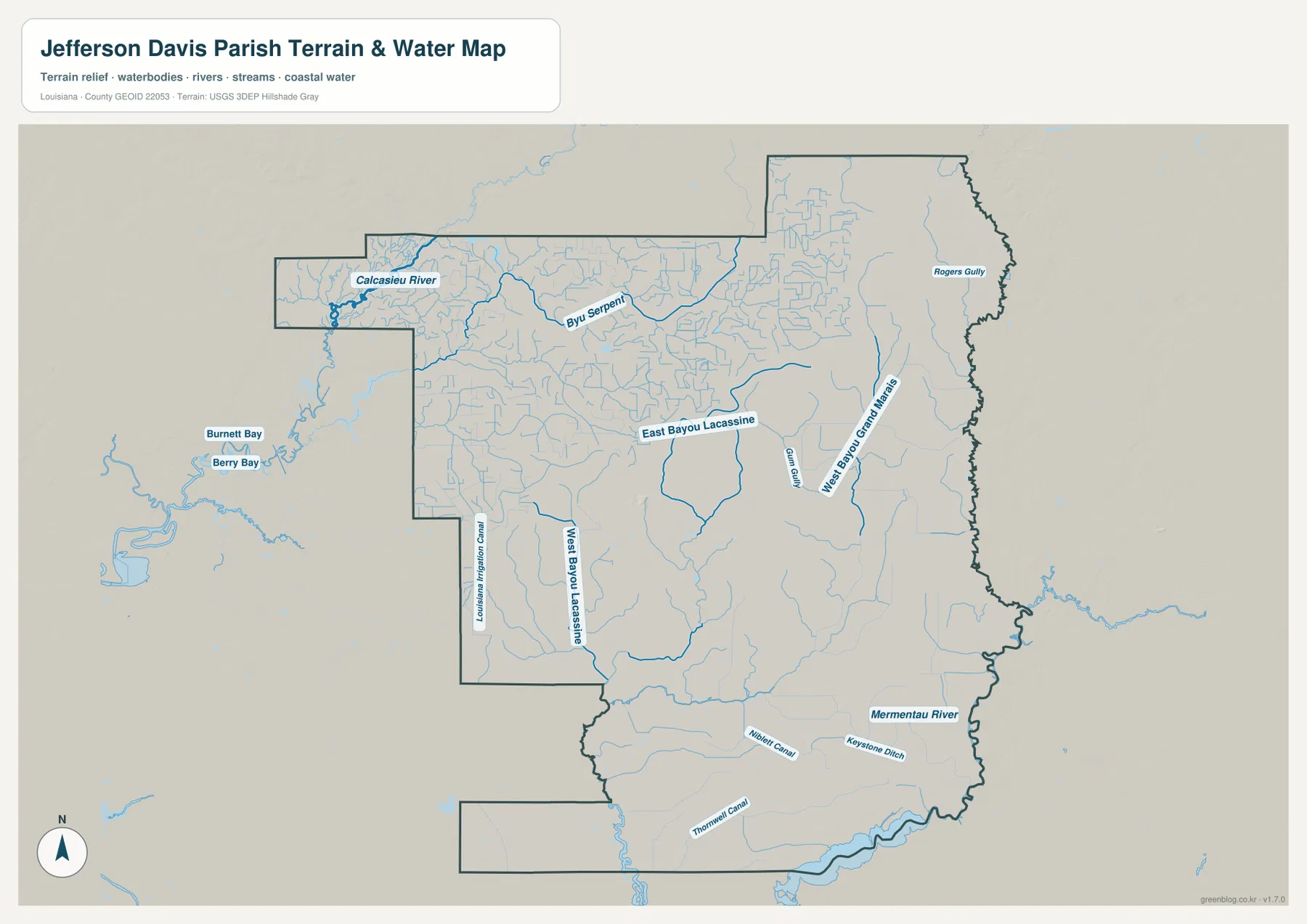
The terrain-and-water map changes the emphasis completely. Mermentau River follows the eastern and southeastern side of the parish and becomes one of the strongest visual boundaries near Lake Arthur. Farther west, East Bayou Lacassine and West Bayou Lacassine run through the interior as separate channels, with many smaller blue lines feeding the same lowland drainage system. These waterways are present on the general map, but removing most road labels makes their density much easier to see.
Several additional names show how varied the drainage network is. West Bayou Grand Marais appears east of the Lacassine channels, with Gum Gully nearby and Rogers Gully farther toward the eastern edge. In the south, Niblett Canal, Keystone Ditch, and Thornwell Canal are labeled alongside natural streams. The combination of bayous, rivers, canals, and ditches is a defining feature of this map and explains why a water-focused view adds information that a highway map cannot provide.
Calcasieu River and Bayou Serpent shape the northwestern extension
The narrow western extension at the top of the parish contains another important water system. Calcasieu River is labeled near its outer end, while Bayou Serpent bends across the interior to the east. That corner can look like an odd appendage on the road map; the water map gives it more context by showing how the boundary and drainage features occupy the same space. It is also a useful reminder that the parish’s major waterways are not confined to the Mermentau River side.
Relief shading on the supplied map is subtle, with no mountain belt or abrupt elevation break dominating the image. The practical value of this layer is therefore the water network rather than exact height measurement. For precise elevation values, a source such as the USGS 3D Elevation Program is more appropriate. For general geography, however, the shaded background helps separate channels and broad low-relief areas without overwhelming the named water features.
Use the three views together for roads, community spacing, and waterways
For basic orientation, the general parish map is the most complete starting point. It combines the parish boundary with Jennings, Welsh, Elton, Fenton, Lake Arthur, Lacassine, Roanoke, and the principal highways. U.S. 90 makes the central corridor easy to follow, while U.S. 165 and U.S. 190 help explain how the northern towns connect to the rest of the parish.
The city-connections map is better when a presentation or quick reference needs only the relative placement of the main communities. The terrain-and-water map is the useful choice for Mermentau River, Calcasieu River, Bayou Serpent, East and West Bayou Lacassine, and the named canals and ditches. Taken together, the maps show a parish with a clear central transportation band but a much more intricate hydrologic pattern extending across the surrounding countryside.
The downloadable ZIP contains the original JPG files corresponding to the maps shown in the article. Each file measures 3638 × 2572 pixels, providing more room to zoom into small route shields and water labels than the WebP previews embedded on the page. The files work well for classroom handouts, printed reference, presentation slides, regional illustration, and personal study. Surveying, legal boundary work, flood determinations, engineering, and navigation should rely on the appropriate current official products instead.
Frequently Asked Questions
What is the parish seat of Jefferson Davis Parish?
Jennings is the parish seat. On the general map it appears near the eastern side of the central U.S. 90 corridor, with LA 26 and LA 102 providing additional north-south connections. The official Louisiana parish profile also identifies Jennings as the seat and lists it as the parish’s city.
Are the 9-, 10-, and 18-mile labels on the city map driving distances?
No. The city-connections map states that its mileage values are direct distances from Jennings. It shows Welsh at 9 miles, Lake Arthur at 10 miles, and Elton and Fenton at 18 miles. Actual road mileage and travel time can be longer, so driving plans should use current navigation and road information.
Which map is best for Mermentau River and Bayou Lacassine?
The terrain-and-water map is the best choice because it emphasizes Mermentau River, East Bayou Lacassine, West Bayou Lacassine, Calcasieu River, Bayou Serpent, West Bayou Grand Marais, and several canals and ditches. It is intended for general geographic reference, not for determining flood risk, water depth, drainage capacity, or navigation safety.
Map File Information
The ZIP contains the original high-resolution JPG files corresponding to the general parish map, city-connections map, and terrain-and-water map shown in this article.
- Included Files: parish map JPG, city-connections map JPG, terrain-and-water map JPG
Related Maps
Sources and references
- Louisiana.gov — Jefferson Davis Parish — official state profile for the parish seat and incorporated communities.
- Louisiana DOTD — Jefferson Davis Parish Official Map — official road, community, boundary, and water reference for the parish.
- USGS National Hydrography — federal hydrography resources for streams and waterbodies.
- USGS 3D Elevation Program — official elevation data for work requiring precise terrain measurements.
- U.S. Census Bureau TIGER/Line — official geographic boundary and transportation data resources.
Green Map creates custom-edited map images using open geographic data sources such as geoBoundaries, Natural Earth, OpenStreetMap, and government open data. These maps are edited visual materials, not raw data files, and are provided for education, documents, presentations, and graphic reference.