Jackson Parish sits in north-central Louisiana, where its main communities are spread very unevenly across the parish. Jonesboro and the Hodge communities form a close cluster on the western side, while Chatham and Eros are separated by much larger stretches of rural land to the east and northeast. The maps on this page show those settlements together with the parish boundary, major highways, streams, and lakes. Matching high-resolution JPG versions are also available in the downloadable ZIP for printing, classroom work, presentations, and general geographic reference.
Jonesboro is the parish seat and the most useful starting point for orientation. Louisiana’s official parish profile lists Chatham, Eros, and Jonesboro as towns and East Hodge, Hodge, North Hodge, and Quitman as villages. The Jackson Parish Police Jury also identifies U.S. Highway 167, Louisiana Highway 4, and Louisiana Highway 34 as major highways, while Caney Lake, Chatham Lake, and the Dugdemona River are among the parish’s named water features. Those same places and routes provide the framework for reading the maps below.
Table of Contents
Jonesboro anchors the western side of the parish
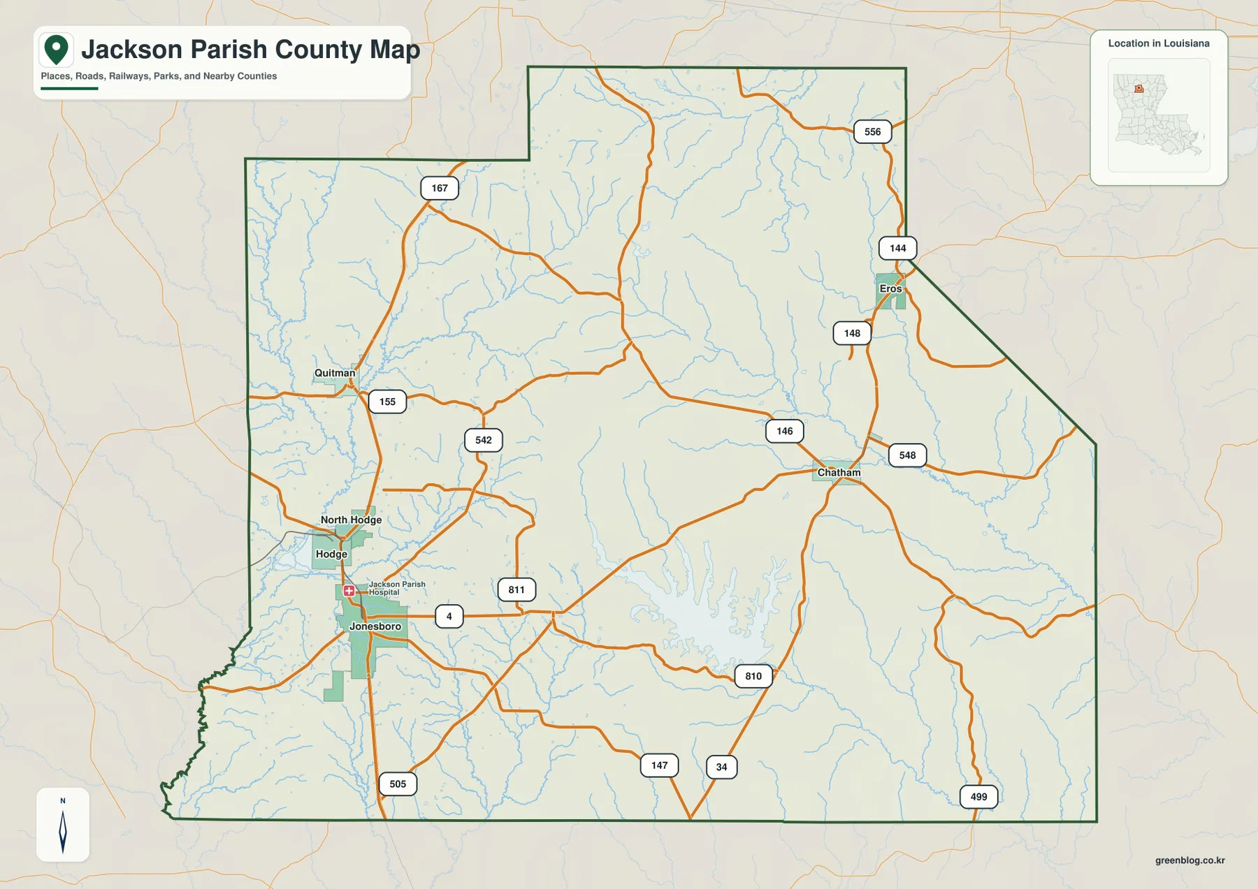
The general parish map shows the strongest concentration of roads and communities around Jonesboro. U.S. 167 runs north-south through this western section, passing the Jonesboro area and continuing toward Quitman. Hodge and North Hodge sit just north of Jonesboro, so several of the parish’s named communities occupy a relatively compact part of the map. LA 4 leaves Jonesboro toward the east, while LA 505 extends south and LA 542 reaches eastward from the Hodge area. Together, those routes make the western side much busier on the road map than the broad interior farther east.
Quitman is positioned farther north and west, near LA 155 and west of U.S. 167. This gives the western settlement pattern a north-south shape rather than a single dense center. The map is useful for seeing how the main highways relate to the communities, but it is not meant to replace current driving directions. Smaller local roads, closures, and travel times can change, so trip planning should still rely on current road and navigation information.
Chatham and Eros open up a much broader eastern road network
East of the Jonesboro cluster, the spacing between communities changes noticeably. Chatham sits in the east-central part of the parish where LA 146 arrives from the west and meets nearby routes such as LA 548, LA 810, and LA 34. Eros is farther north and east, close to LA 144 and LA 148, with LA 556 appearing near the northeastern boundary. Instead of one tight urban group, the eastern half is crossed by several state highways that connect small communities through a wide rural interior.
The parish outline also helps explain the placement of those towns. The northern boundary rises in a stepped shape, while the eastern boundary angles inward north of Chatham before slanting toward the southeast. Eros therefore sits close to the northeastern edge, and Chatham occupies a central position near the angled eastern side. The city-distribution map labels the surrounding parishes as well, including Lincoln to the north, Ouachita and Caldwell to the east, Winn to the west, and Bienville to the northwest. The Police Jury community profile lists those same neighboring parishes, which provides a useful check on the broader location.
The city index makes the Jonesboro-Hodge concentration easy to see
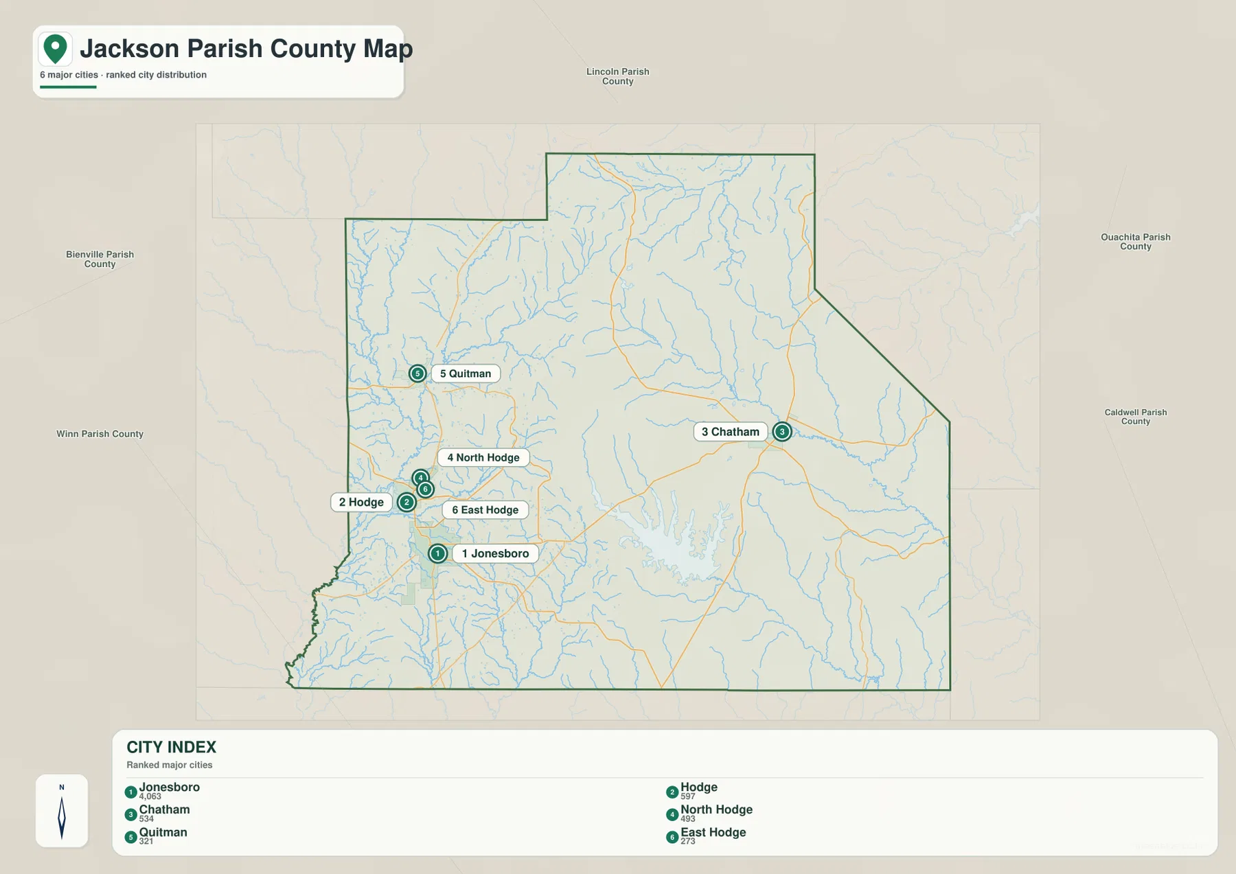
The city-distribution map strips away most road detail and focuses on six named communities. Jonesboro is ranked first in the map’s city index, followed by Hodge, Chatham, North Hodge, Quitman, and East Hodge. Those rankings and numbers belong to the index used to build this map; they should be treated as a visual reference rather than as a replacement for a current census table. Their main purpose here is to make the relative prominence and geographic spacing of the communities easy to compare.
Four of the six labels—Jonesboro, Hodge, North Hodge, and East Hodge—sit close together on the western side. Quitman is separated to the north, while Chatham stands well to the east. That arrangement is more obvious in the simplified city view than on the road-heavy general map. For a slide or short regional overview, the city map quickly communicates that Jackson Parish does not have evenly distributed population centers; much of the named settlement is concentrated in the west, with Chatham acting as the principal eastern counterpoint.
Caney Lake stands out in the central-southern interior
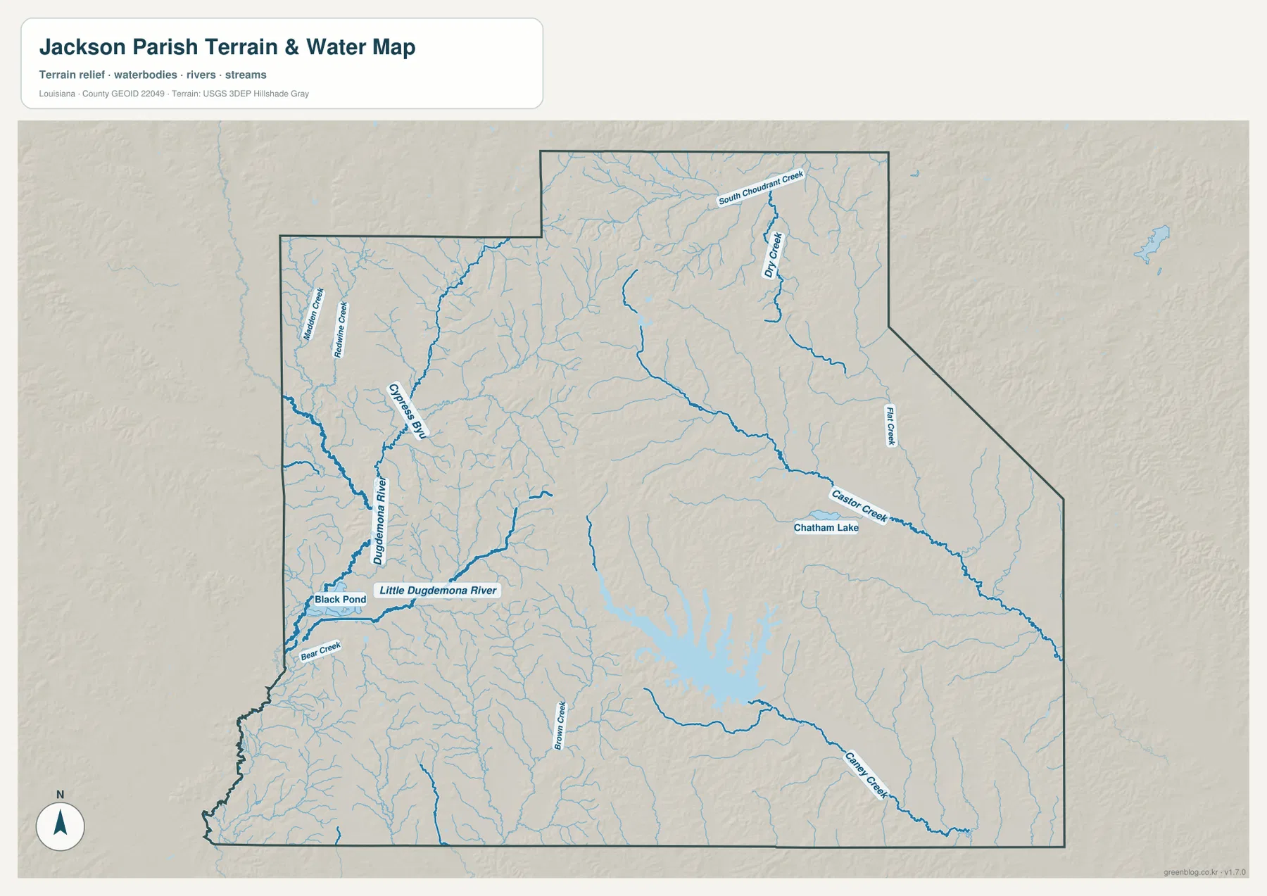
The terrain-and-water map shifts attention away from highways and toward the parish’s drainage network. The large reservoir in the central-southern interior is Caney Lake, also known as Caney Creek Reservoir. Jackson Parish’s official local-government site identifies Caney Lake as a major parish recreation resource and places Jimmie Davis State Park on the lake. On the map, the reservoir’s branching shoreline is visually different from the narrow creeks around it, making it one of the easiest natural features to locate.
Caney Creek continues toward the southeast, while Brown Creek appears to the southwest of the reservoir. Chatham Lake is labeled farther northeast near the Castor Creek system. The shaded relief does not provide exact elevation numbers, but it helps separate creek valleys and the higher ground between them. That makes the water map useful when the goal is to understand why roads and communities occupy certain areas without turning the page into a technical topographic study.
Dugdemona River and Little Dugdemona define the western drainage
The western water system has a different character from the creeks near Chatham. Dugdemona River runs along the western side, with Little Dugdemona River joining the drainage farther south. Cypress Bayou approaches from the northwest, and Black Pond and Bear Creek are labeled near the western edge. This network lies close to the same part of Jackson Parish where Jonesboro and the Hodge communities are concentrated, so comparing the water map with the road map helps connect settlement geography with the surrounding river system.
On the eastern side, Castor Creek crosses the parish near Chatham, while Dry Creek and South Choudrant Creek appear farther north and Flat Creek is labeled near the eastern boundary. Smaller names such as Wildhorse Creek and Rushing Creek show how dense the tributary network becomes once road labels are removed. The pattern is not one dominant river across the whole parish. Instead, a major western river system, a large central reservoir, and many eastern creeks divide the landscape into several distinct drainage areas.
Choose the map by whether you need roads, communities, or waterways
For a first look at Jackson Parish, the general map is the most complete choice because it combines the boundary, named communities, and principal highways. U.S. 167 gives the western side a clear north-south reference, while LA 4 and LA 146 help trace movement toward the interior and Chatham. It is the best of the supplied maps for explaining where places are and how the major road network fits together.
The city-index map works better when the question is simply where the main settlements are concentrated. The terrain-and-water map is the better option for Caney Lake, Dugdemona River, Little Dugdemona River, Castor Creek, Chatham Lake, and the many smaller tributaries. Looking at all three together gives a fuller picture of the parish: western settlement concentration, a broad eastern interior, and a water network that is much more detailed than the road map alone suggests.
The downloadable archive contains the original JPG files corresponding to the three maps shown in the article. Each image is 3638 × 2572 pixels, so the files provide more room for zooming, printing, and reading smaller road or stream labels than the WebP previews on the page. They are well suited to classroom materials, presentations, personal reference, and general regional illustration. Surveying, legal boundary decisions, flood determinations, engineering, and water navigation require the appropriate current official products instead.
Frequently Asked Questions
What is the parish seat of Jackson Parish?
Jonesboro is the parish seat. On the general map it sits near the western side of Jackson Parish at a key point in the local road network, with U.S. 167 running north-south and LA 4 extending eastward. Hodge and North Hodge are immediately to the north, which makes Jonesboro a convenient reference point for understanding the western settlement cluster.
Which map is best for Caney Lake and the Dugdemona River?
The terrain-and-water map is the best choice. It emphasizes Caney Lake in the central-southern interior, Dugdemona River and Little Dugdemona River on the west, and Castor Creek, Dry Creek, Flat Creek, Chatham Lake, and other tributaries across the parish. It is a general geographic reference rather than a flood, depth, or navigation map.
Are the rankings and numbers on the city map current population statistics?
No. The map uses a city index to rank and locate Jonesboro, Hodge, Chatham, North Hodge, Quitman, and East Hodge. Those values are useful for comparing the relative prominence and position of the mapped communities, but current population figures should be checked against an official source such as the U.S. Census Bureau.
Map File Information
The ZIP contains the original high-resolution JPG files corresponding to the general parish map, city-distribution map, and terrain-and-water map shown in this article.
- Included Files: parish map JPG, city-distribution map JPG, terrain-and-water map JPG
Related Maps
Sources and references
- Louisiana.gov — Jackson Parish — official state profile for the parish seat and municipalities.
- Jackson Parish Police Jury — Community Profile — local-government reference for major highways, neighboring parishes, and named lakes and rivers.
- Jackson Parish Police Jury — Caney Lake — local information on Caney Lake and Jimmie Davis State Park.
- Louisiana DOTD — Jackson Parish Official Map — official road, community, water, and boundary reference.
- USGS National Hydrography — federal hydrography resources for streams and waterbodies.
- U.S. Census Bureau TIGER/Line — official geographic boundary and transportation data resources.
Green Map creates custom-edited map images using open geographic data sources such as geoBoundaries, Natural Earth, OpenStreetMap, and government open data. These maps are edited visual materials, not raw data files, and are provided for education, documents, presentations, and graphic reference.