Fallon County sits on Montana’s eastern edge, with Baker serving as the main road and community reference and Plevna lying to the west along the U.S. 12 corridor. The county has an irregular outline that spreads widely across the north and west before narrowing into a long southeastern extension. O’Fallon Creek crosses much of the western side, while Lake Baker, Cabin Creek, Sandstone Creek, and Little Beaver Creek provide useful landmarks elsewhere. The maps shown on this page are also available together as high-resolution JPG files in the download ZIP below.
Fallon County’s official site describes the county as part of eastern Montana along the North Dakota border, while USDA NRCS identifies Baker as the county seat and Plevna as the other incorporated community. Those two places form a simple starting point for the map set. Baker anchors U.S. 12 and Montana Highway 7, Plevna marks the western road corridor, and the creek network fills the broad rural areas between and around them.
Table of Contents
Baker is the road hub where U.S. 12 and Montana 7 meet
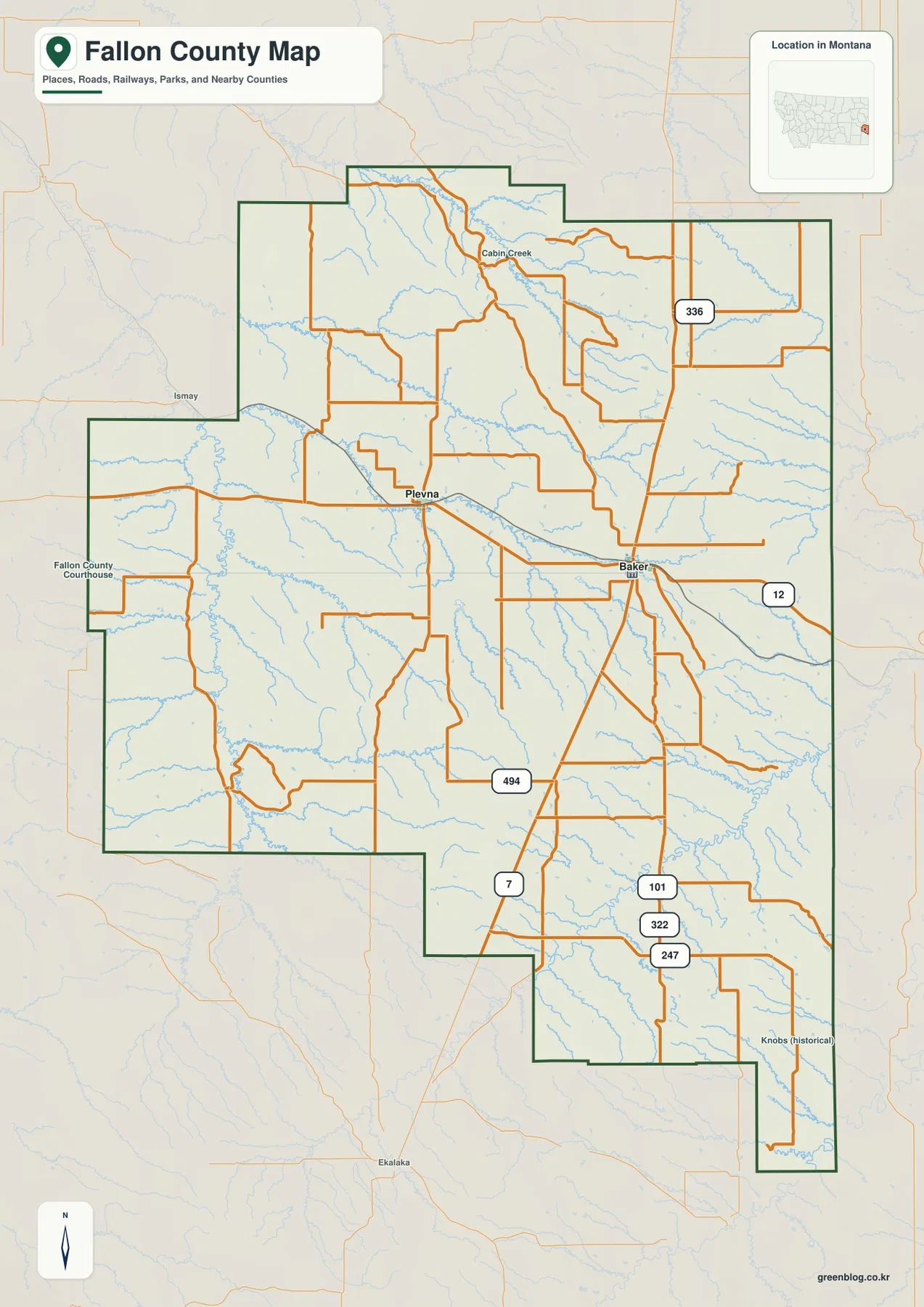
On the general county map, Baker appears in the east-central part of Fallon County. U.S. 12 runs east and west through the city, while Montana 7 heads south into the county’s long lower section. Route 336 is labeled north of Baker, and several local roads branch outward from the same area. This makes Baker the easiest place to begin when locating almost any other part of the county.
Plevna lies west of Baker near U.S. 12 and the railroad corridor. Ismay appears beyond the county to the west, and Ekalaka is labeled well south of the county boundary, helping place Fallon County relative to neighboring communities. The western half contains a broad network of rural roads, while the eastern and southeastern sections are more strongly organized around roads that leave Baker.
South of Baker, Route 494 is labeled before the road network splits again toward routes 101, 322, and 247 in the southeast. Route 336 continues through the northeastern interior. These numbers are useful for orientation, but the map is static. Construction, unpaved-road conditions, winter weather, and actual travel time should be checked with current transportation or navigation information.
The city map highlights only Baker and Plevna
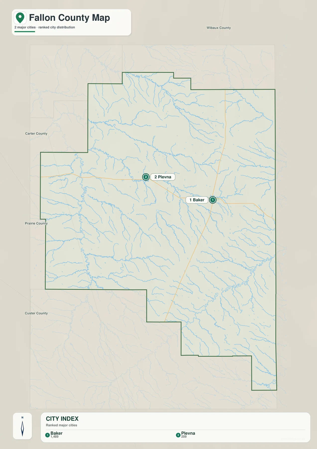
The city map ranks two places: Baker and Plevna. Its printed index shows a value of 1,489 for Baker and 209 for Plevna. Those are the values embedded in the supplied map and should not be treated as guaranteed current population estimates. Anyone needing current demographic figures should consult recent U.S. Census Bureau data.
Their positions are more useful than the ranking itself. Baker sits in the east-central part of the county at the main highway junction, while Plevna is farther west along the U.S. 12 corridor. Neighboring county labels around the outside of the map help place Fallon County in southeastern Montana and show how close its eastern side lies to the state border region.
No connector line or mileage value is printed between Baker and Plevna on this city map. The gap between the markers should therefore be treated only as a location reference, not as road mileage or straight-line distance. For an actual trip, the general map and current navigation information are more appropriate.
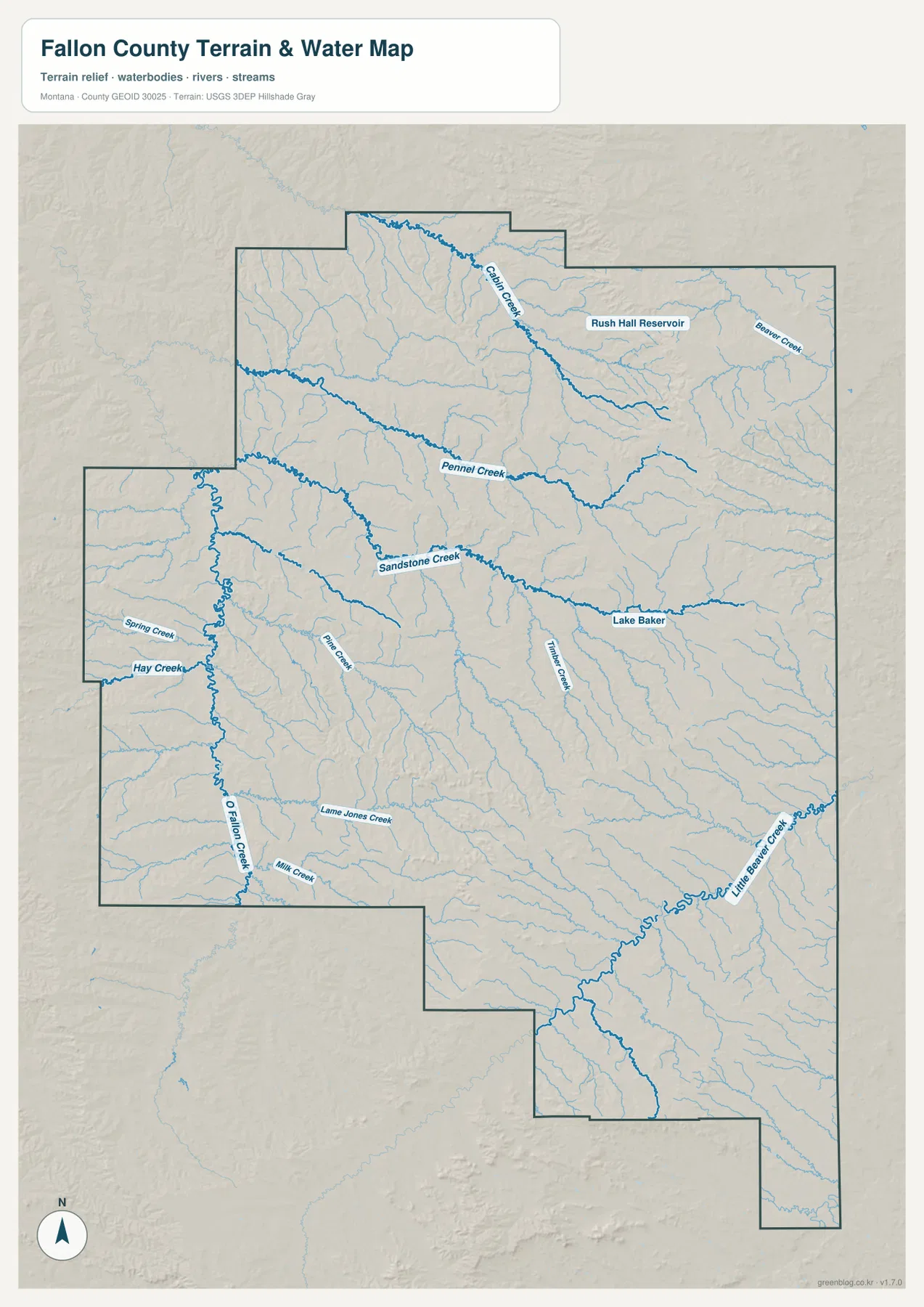
O’Fallon Creek is the strongest water reference on the western side
The terrain-and-water map makes O’Fallon Creek the most prominent named drainage across the western and southwestern part of the county. Spring Creek and Hay Creek approach from the west, while Mill Creek and Lame Jones Creek appear farther south. Following O’Fallon Creek first is an easy way to organize an area that contains many smaller unnamed tributaries.
East of O’Fallon Creek, Pine Creek runs through the interior and Sandstone Creek forms a long central drainage. Pennel Creek lies farther north, and Cabin Creek descends across the northern part of the county. These creeks are smaller than major rivers elsewhere in Montana, but they define many of the low valleys visible in both the water and elevation maps.
This terrain-and-water map is intended for geographic reference. It does not establish flood zones, water depth, parcel boundaries, water rights, or safe crossing locations. Current access and water conditions should be checked with the appropriate local or state source before field use.
Lake Baker and Little Beaver Creek help organize the eastern half
Lake Baker is labeled close to Baker and provides an easy local reference in the east-central part of the county. Visit Baker Montana describes the lake as a local recreation area with a beach, walking path, birdwatching, kayaking, and paddleboarding. On the county water map, it sits near the drainage network east of Sandstone Creek and helps connect the city location with the surrounding terrain.
Beaver Creek is labeled in the northeast, while Little Beaver Creek runs through the long southeastern extension. The Little Beaver valley is accompanied by many short tributaries and a more dissected terrain pattern than the broad low country in the northwest. Once Baker and Lake Baker are located, following Little Beaver Creek south makes the county’s unusual boundary shape much easier to understand.
Rush Hall Reservoir appears in the northern half between the Cabin Creek and Beaver Creek areas. Although it is a small water body at county scale, its label is useful in a part of the map where many creeks look similar. Reservoir levels and access can change, so current local information should be used for any visit.
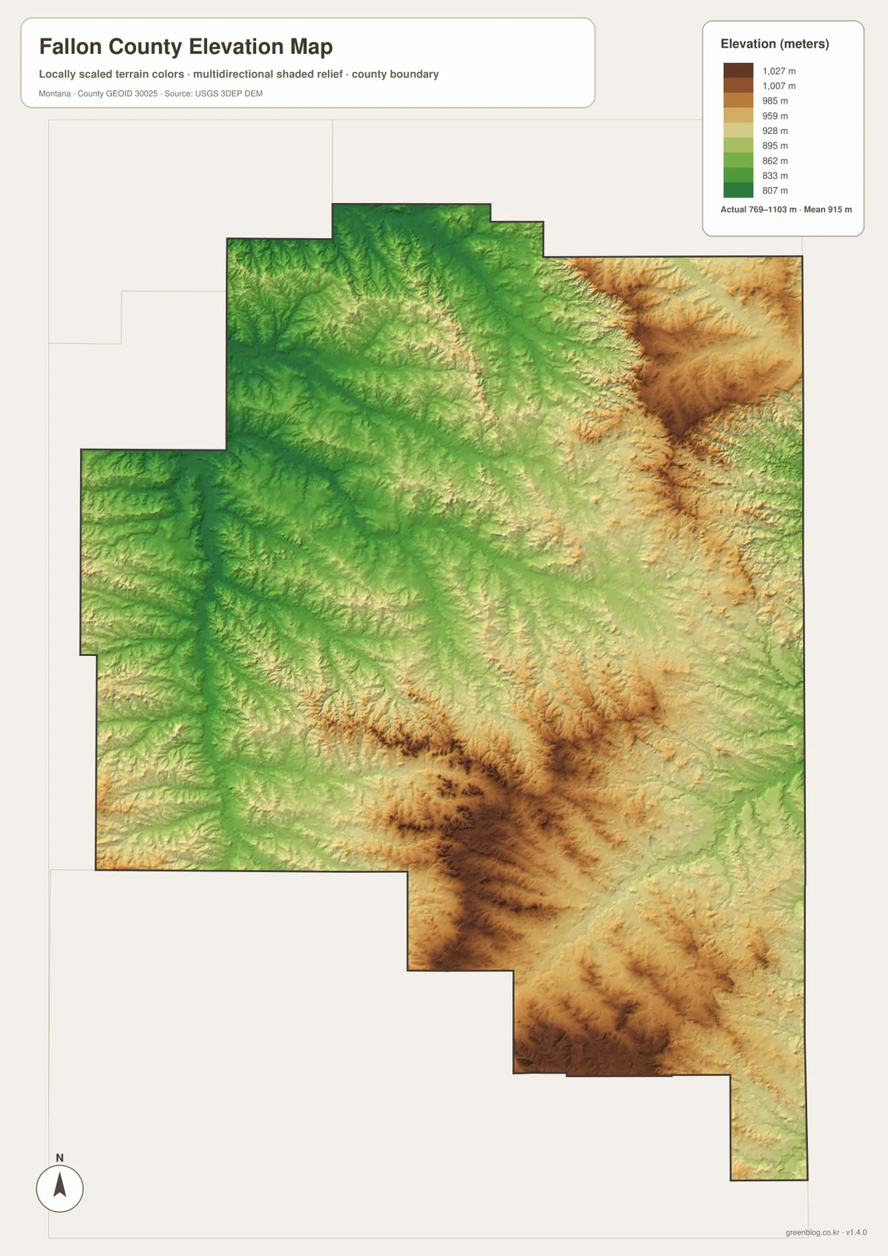
Elevation ranges from about 769 to 1,103 meters
The elevation map reports an actual county range of about 769 to 1,103 meters, with a mean elevation near 915 meters. Broad areas in the west and northwest appear in lower green tones, while higher yellow and brown terrain is concentrated in the northeast, south-central interior, and southeastern section. The county does not contain high mountains, but the difference between creek valleys and surrounding uplands is clear.
The northeastern high ground is cut by many narrow drainages. This matches the water map, where Cabin Creek and Beaver Creek are surrounded by branching tributaries. A separate concentration of higher terrain appears in the south-central part of the county, with small valleys radiating away from the upland into lower green corridors.
The long southeastern extension also contains repeated higher ridges, while Little Beaver Creek occupies a lower route through the terrain. The elevation map is suitable for county-wide comparison, not for surveying, engineering, construction, or determining the precise elevation of an individual property.
Baker and Plevna provide a simple starting point for the full map set
A practical way to use the maps is to locate Baker first, then Plevna to the west. U.S. 12 connects the two areas on the road map, while Montana 7 heads south from Baker and Route 336 heads north. Once that framework is familiar, the smaller southeastern routes and wide western rural road network become easier to place.
Waterways add a second layer of orientation. O’Fallon Creek organizes the west, Sandstone Creek the central interior, Cabin Creek the north, and Little Beaver Creek the southeast. Lake Baker gives the city area an easy water landmark. On the elevation map, those drainage corridors appear lower than the surrounding uplands, making the relationship between water and terrain easy to see.
The WebP images embedded in the article are convenient for quick browsing. The high-resolution JPG files in the ZIP are better for printing or enlarging small road, creek, and reservoir labels. Because these are static reference maps, changing conditions such as road closures, water levels, and access restrictions should be checked through current official or local sources.
Frequently Asked Questions
Does the city map show the distance between Baker and Plevna?
No. The city map ranks and locates Baker and Plevna but does not print a connector distance or road mileage between them. The general county map shows U.S. 12 linking the two areas, while current navigation data should be used for actual travel distance.
Where is O’Fallon Creek on the Fallon County map?
O’Fallon Creek runs through the western and southwestern part of the county. Spring Creek and Hay Creek join its broader drainage area, while Sandstone Creek lies farther east. It is one of the easiest water features to use as a western reference.
Can the 769–1,103 meter elevation range be used for property or engineering work?
No. The range is a county-wide reference for comparing lower creek valleys with higher uplands. Precise site elevations should come from an authoritative source such as the USGS 3D Elevation Program and, when necessary, a professional survey.
Map File Information
Download the Fallon County county, city, terrain-and-water, and elevation maps as high-resolution A3 JPG files.
- Included Files: county map, city map, terrain and water map, elevation map
- File Type: ZIP containing 4 JPG files
Related Maps
Sources and References
Fallon County provides county background and location information on its official county page. The USDA NRCS Fallon County profile identifies Baker as the county seat and Plevna as the other incorporated community. Local information about Lake Baker is available from Visit Baker Montana.
Boundary and road-reference data can be checked through U.S. Census Bureau TIGER/Line Shapefiles. Hydrographic reference data are available from USGS National Hydrography, and elevation data can be checked through the USGS 3D Elevation Program.
Green Map creates custom-edited map images using open geographic data sources such as geoBoundaries, Natural Earth, OpenStreetMap, and government open data. These maps are edited visual materials, not raw data files, and are provided for education, documents, presentations, and graphic reference.