Deer Lodge County in southwestern Montana is dominated by the contrast between the Anaconda basin in the northeast and much higher mountain country to the west and southwest. The general map concentrates roads, medical facilities, and an airfield around the Anaconda area, while the rest of the county spreads into rugged terrain with few settlement labels. The terrain-and-water map adds Warm Springs Creek, Lost Creek, Mill Creek, Big Hole River, and a group of mountain lakes that make the valley pattern easier to follow. High-resolution JPG versions of the maps shown on this page are available together in the download ZIP below.
The map labels the principal urban area as Anaconda-Deer Lodge County, the same name used by the county’s official website. From that northeastern basin, the landscape rises rapidly toward the western mountains and then opens into a separate southern system of creeks and river valleys. Warm Springs Creek and Lost Creek organize the northern half, while Seymour Creek and the Big Hole River become better references farther south. Using those waterways along with Anaconda provides a simple way to make sense of the county’s irregular outline.
Table of Contents
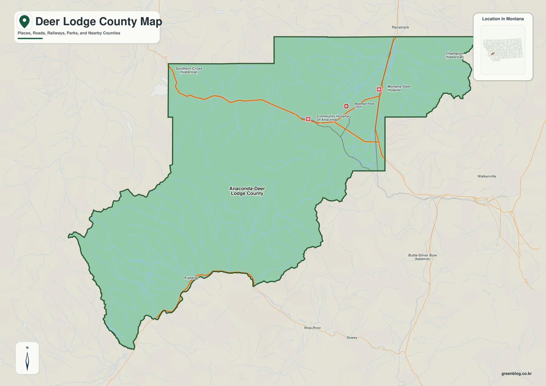
Roads and major facilities cluster around the Anaconda area
On the general county map, the strongest concentration of mapped facilities lies in the northeast around Anaconda. Community Hospital of Anaconda is labeled near the central road corridor, Bowman Field (3U3) appears a short distance to the east, and Montana State Hospital is marked farther northeast. The main road network also converges in this part of the county before climbing toward higher terrain or leaving the county boundary.
Southern Cross is labeled as a historical place near the western side of the northern section, while Champion appears as another historical place near the northeastern edge. Racetrack is shown just outside the northern boundary, Walkerville lies to the east, and Butte-Silver Bow appears beyond the southeastern side. Fishtrap is labeled near the southern boundary, with Wise River and Dewey farther outside the county.
The boundary itself is highly irregular. It steps across the north and east before widening dramatically into the mountainous southwest. The Anaconda side therefore feels compact and connected by roads, while much of the southern and western county is better understood through valleys, lakes, and mountain relief. The map is useful for orientation but does not replace current road-condition or seasonal-access information.
The city view highlights one principal urban area
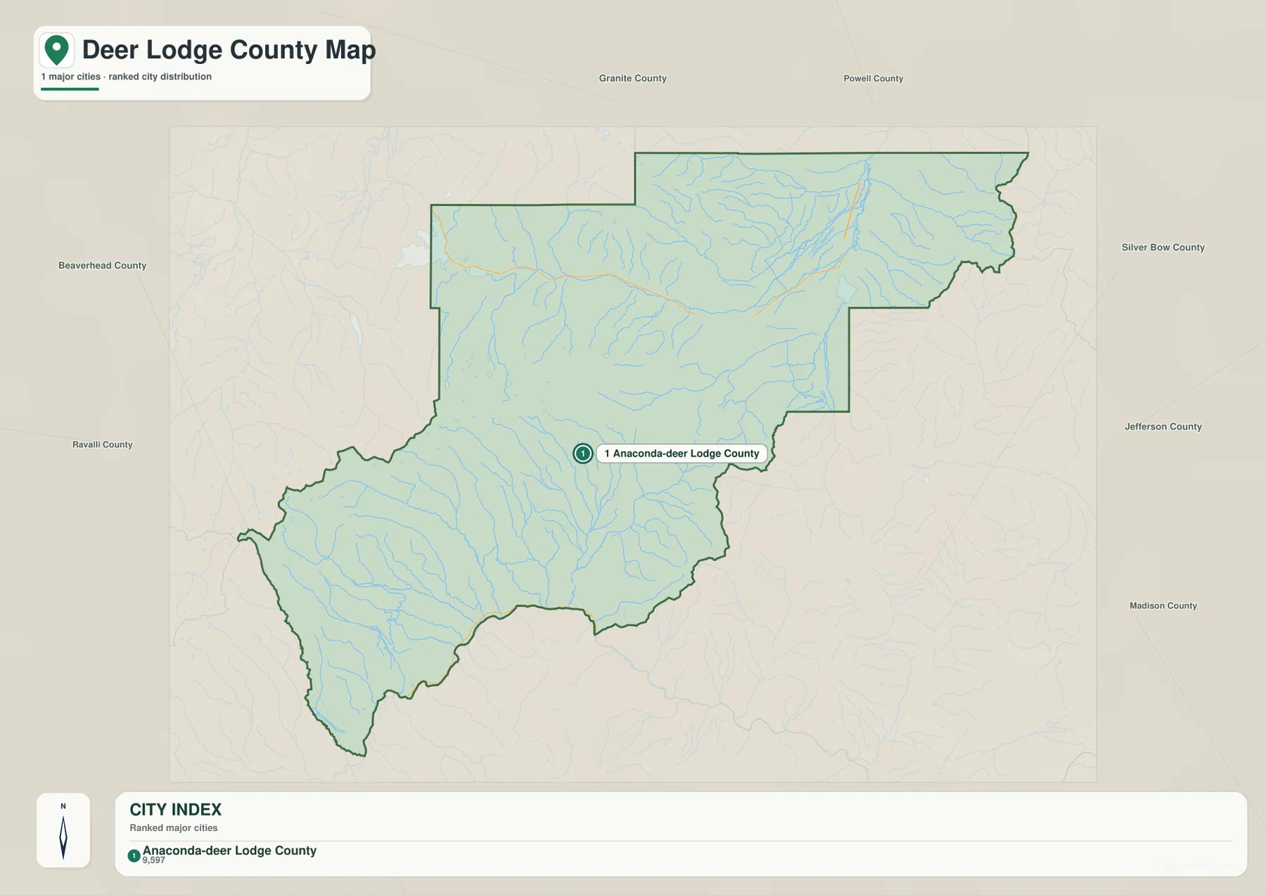
The city map ranks one major urban area and labels it Anaconda-Deer Lodge County. The printed index shows a value of 9,597. That figure is the value embedded in the supplied map and should not be treated as a guaranteed current population estimate. Readers who need current demographic data should consult recent U.S. Census Bureau releases.
With only one ranked marker, the map makes the county’s settlement pattern especially clear. The principal urban area sits in the northeastern basin, while a very large portion of the county stretches south and southwest without another ranked city marker. Neighboring counties—Granite, Powell, Silver Bow, Jefferson, Madison, Beaverhead, and Ravalli—are labeled around the outside, helping place Deer Lodge County within southwestern Montana.
There is no city-to-city connector or distance label on this map because only one ranked urban area is shown. It is therefore best used to locate the Anaconda area inside the county rather than to estimate mileage. Smaller place names, roads, and facilities are easier to find on the general county map.
Warm Springs Creek and Lost Creek define the northeastern basin
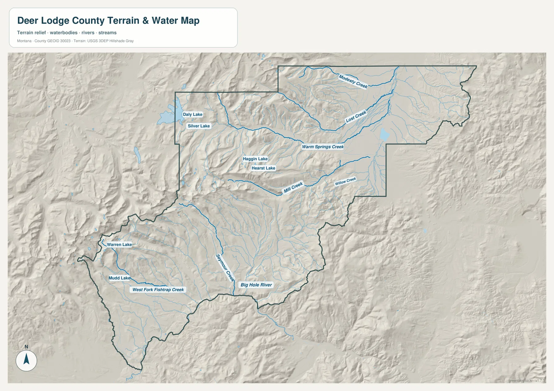
The terrain-and-water map shows Warm Springs Creek running through the broad northeastern basin. Lost Creek descends from higher northern terrain into the same general lowland, while Modesty Creek crosses the far northern section. These waterways make it easier to see the difference between the lower Anaconda-side basin and the steep mountains immediately to the west.
Mill Creek and Willow Creek lie farther south. Mill Creek comes out of the western mountains and runs eastward, while Willow Creek occupies a parallel lower corridor to the south. The hillshade around these creeks is much stronger than on the basin floor, so following the blue stream lines is a straightforward way to locate the lower passages between ridges.
Several named lakes sit in the mountain country west of the basin. Daly Lake and Silver Lake are close together in the northwest, while Haggin Lake and Hearst Lake lie farther southeast. They are much smaller than a large reservoir but work well as local reference points within a complex group of ridges and valleys. This map is a geographic water reference, not a flood map, navigation chart, parcel survey, water-rights record, or guide to safe access.
Seymour Creek and Big Hole River organize the southern half
South of the central mountains, Seymour Creek becomes one of the clearest named waterways. It runs through the south-central part of the county toward the lower Big Hole River corridor near the southern boundary. West Fork Fishtrap Creek is labeled farther southwest, providing another useful reference for the Fishtrap side of the county.
Warren Lake and Mudd Lake appear in the southwestern mountain area. The surrounding hillshade is much more rugged than the Anaconda basin, with closely spaced ridges and narrow valleys. In this part of the county, waterways and lakes are often more useful location references than settlement names because the map contains few urban labels.
The Big Hole River appears only along the southern edge of the county map, but it still provides an important geographic anchor. A wide band of mountainous ground separates it from the northeastern Anaconda basin. Anyone using these maps for field access, fishing, or land decisions should pair them with current agency and property-specific information rather than relying on a static county overview.
Elevation ranges from about 1,427 to 3,275 meters
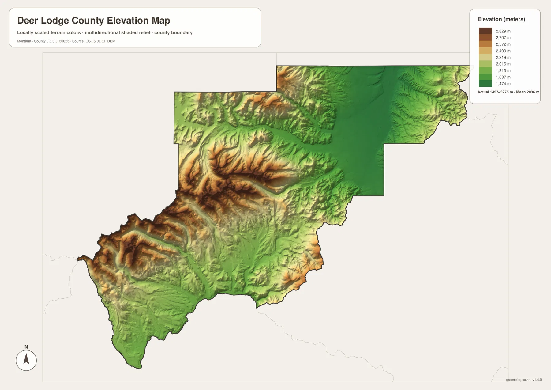
The elevation map reports an actual county range of about 1,427 to 3,275 meters, with a mean elevation near 2,036 meters. The Anaconda-side basin in the northeast appears as a broad dark-green lowland, while yellow, orange, and brown terrain rises quickly to the west and southwest. The contrast is unusually strong for such a compact county, with low basin ground and mountains above 3,000 meters inside the same boundary.
High ridges dominate much of the west-central and southwestern county. The mountain-lake area around Daly, Silver, Haggin, and Hearst lakes falls within this higher terrain. By comparison, Warm Springs Creek and Lost Creek occupy the broadest continuous low area in the northeast. The elevation view therefore matches the water map closely: lakes sit among high ridges, while the main creeks follow lower passages toward the basin.
In the south, Seymour Creek and the Big Hole River also occupy lower corridors between higher mountain blocks. Their valleys are visible as green cuts through otherwise yellow and brown relief. The elevation surface is intended for county-wide comparison only and should not be used for surveying, engineering, construction, or determining the exact elevation of a specific property.
Separating the Anaconda basin from the southwest makes the map easier to use
A practical way to read the map set is to divide the county into two broad areas. In the northeast, start with the Anaconda urban area, major facilities, Warm Springs Creek, and Lost Creek. Then move west to Daly and Silver lakes or south to Mill and Willow creeks. This sequence keeps the dense northern terrain from becoming a collection of disconnected names.
For the southern half, Seymour Creek is the easiest stream to locate first. Big Hole River and West Fork Fishtrap Creek then define the lower edge and southwest, while Warren and Mudd lakes identify the mountain interior. The elevation map reinforces the same pattern by showing deep green valleys cutting through broad high ridges.
The WebP images in the article are convenient for quick viewing. The high-resolution JPG files in the ZIP are better for printing or enlarging small stream, lake, road, and facility labels. These are static reference maps, so road closures, water levels, and land-access conditions should be checked with current official information before travel or field use.
Frequently Asked Questions
Why does the map use the name Anaconda-Deer Lodge County?
The supplied map labels the principal urban area as Anaconda-Deer Lodge County, and the county’s official website uses the same name. On this map set, that label identifies the Anaconda-centered area in the northeastern part of Deer Lodge County.
Where is the lowest broad area on the elevation map?
The largest continuous low area is the northeastern basin around Anaconda. Warm Springs Creek and Lost Creek also pass through this lower terrain, while elevations rise quickly into the western and southwestern mountains.
Can the 1,427–3,275 meter elevation range be used for a property or engineering project?
No. The range is intended for county-wide comparison between the low basin and surrounding mountains. Precise site elevation should come from an authoritative source such as the USGS 3D Elevation Program and, when necessary, a professional survey.
Map File Information
Download the Deer Lodge County county, city, terrain-and-water, and elevation maps as high-resolution A3 JPG files.
- Included Files: county map, city map, terrain and water map, elevation map
- File Type: ZIP containing 4 JPG files
Related Maps
Sources and References
Official local information is available from the Anaconda-Deer Lodge County website. Additional county background is available from Montana State University Extension.
Boundary and road-reference data can be checked through U.S. Census Bureau TIGER/Line Shapefiles. Hydrographic reference data are available from USGS National Hydrography, and elevation data can be checked through the USGS 3D Elevation Program.
Green Map creates custom-edited map images using open geographic data sources such as geoBoundaries, Natural Earth, OpenStreetMap, and government open data. These maps are edited visual materials, not raw data files, and are provided for education, documents, presentations, and graphic reference.