Daniels County occupies the far northeastern part of Montana, with Scobey near the center of the county’s road network and Flaxville, Peerless, and Whitetail spread across a broad rural landscape. Routes 5, 13, 248, 251, and 511 provide the clearest road references. The water map is even more distinctive: the Poplar River and its Middle, East, and West forks divide the county into long creek valleys, while the elevation map shows a lower central river corridor between higher western uplands. High-resolution JPG versions of the maps shown here are available together in the download ZIP below.
The official Daniels County website places county government in Scobey, and the USDA Natural Resources Conservation Service describes the county as being drained mainly by the Poplar River and its major forks. Both points match the maps well. Scobey is the easiest settlement reference, but away from the towns the waterways become more useful than place names. Finding Scobey first and then tracing the Poplar River branches is a practical way to understand the county without turning the map into a long list of local roads.
Table of Contents
Scobey provides the simplest starting point for the road map
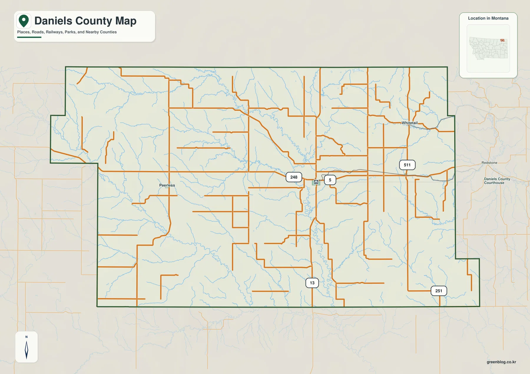
On the general county map, Scobey lies close to the center. Route 5 passes east and west through the area, Route 13 runs south, and Route 248 is labeled on the western approach. Peerless sits farther west, while the road east leads toward Flaxville. Whitetail appears separately in the northeastern part of the county. These four place names give the map an easy center-and-edges structure.
The northeastern road network includes Route 511, and Route 251 runs through the southeastern part of the county. Several smaller roads form long straight segments across the open interior before bending around creek valleys or the stepped county boundary. The western side looks more irregular because both the county outline and the terrain break into more pronounced ridges and drainages.
Peerless and Whitetail are especially useful for understanding the county’s width. They sit on opposite sides of Scobey and make it clear that Daniels County covers a large rural area despite having only a few major settlement labels. The road map is suitable for orientation, but current maintenance, winter conditions, construction, and unpaved-road access should be checked separately before travel.
The city map focuses on Scobey and Flaxville
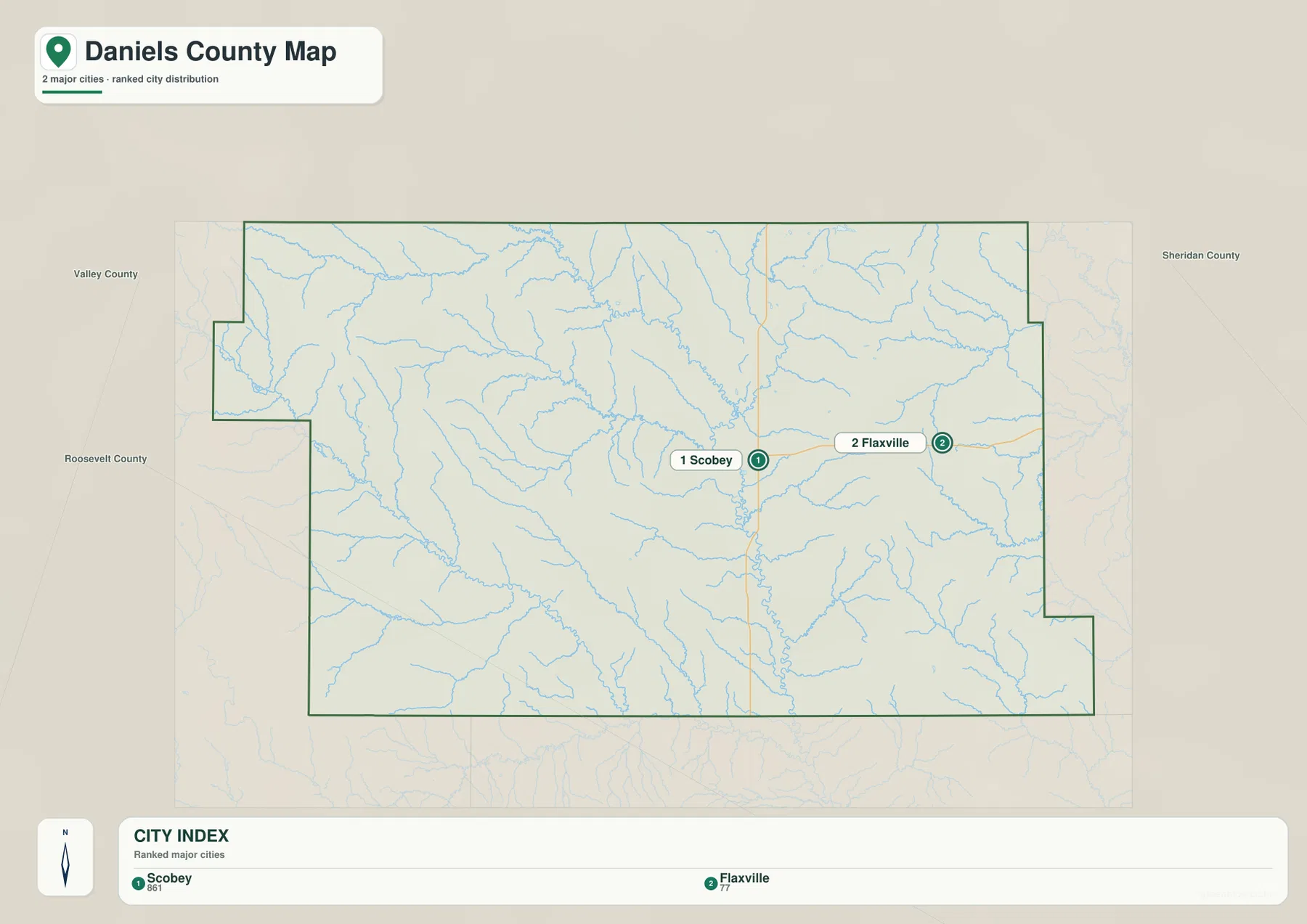
The city map ranks two places: Scobey and Flaxville. Its printed index shows Scobey at 861 and Flaxville at 77. These figures are the values embedded in the supplied map and should not be treated as guaranteed current population estimates. For current demographic totals, readers should use recent U.S. Census Bureau data.
The simplified view is useful because it removes most road labels and shows the two settlements within the county boundary. Scobey sits near the middle, while Flaxville lies to the east. Valley and Roosevelt counties are labeled on the west side, and Sheridan County is shown to the east, which helps place Daniels County within the surrounding northeastern Montana counties.
There is no connector line or mileage value between Scobey and Flaxville on this city map. Their spacing should therefore be read only as a location reference, not as straight-line distance, road mileage, or travel time. The full county map is the better choice for tracing Route 5 and the local roads between the two communities.
Poplar River forms the main north-south water corridor
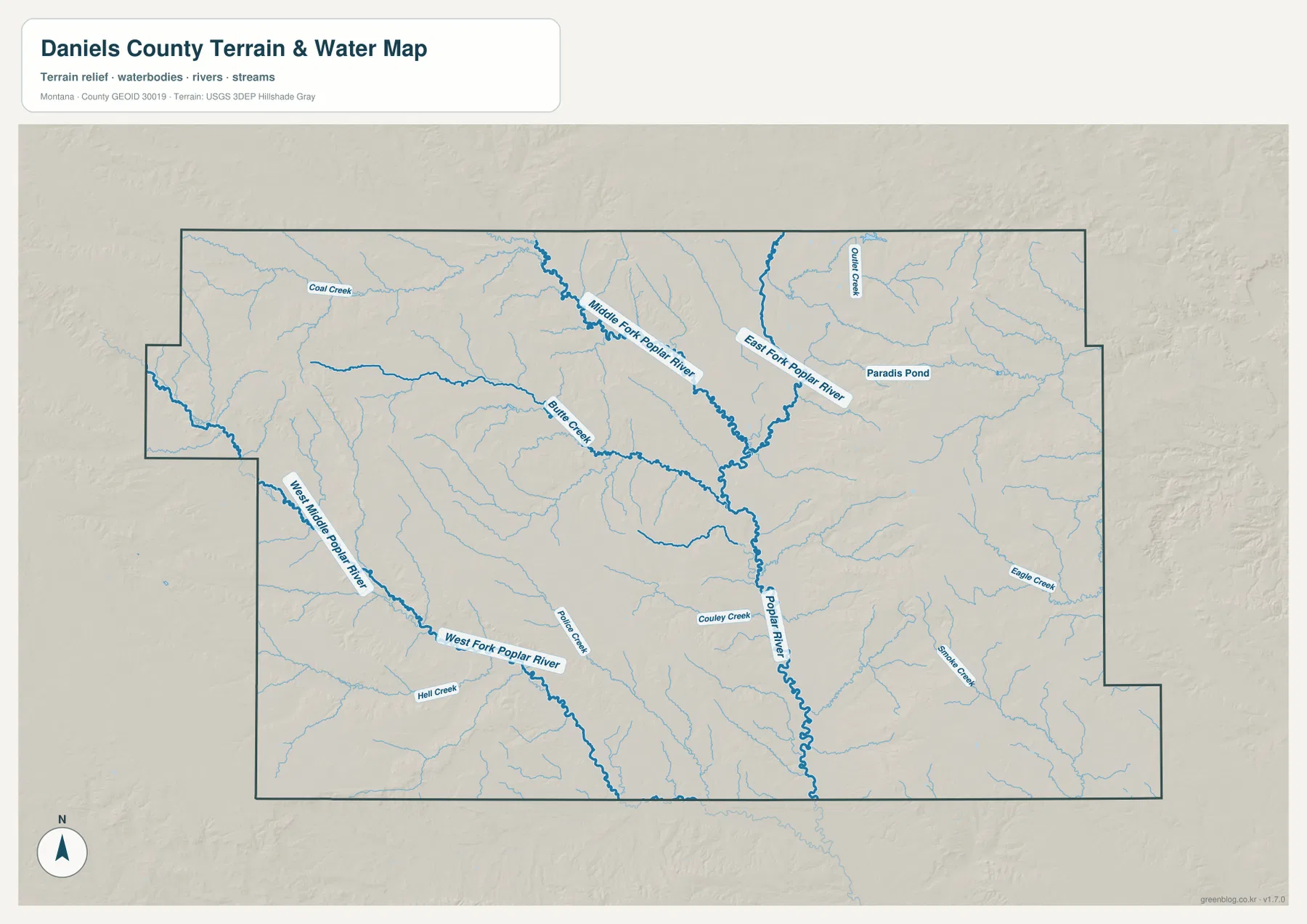
The terrain-and-water map makes the Poplar River the strongest central feature. It runs south through the middle of Daniels County and receives multiple branches from the north and west. Once the main river is located, the rest of the map becomes easier to organize because many smaller creeks lead toward the same low central corridor.
The Middle Fork Poplar River descends from the north-central area, while the East Fork Poplar River approaches from the northeast. Their valleys converge toward the central Poplar River system. Outlook Creek and Paradise Pond are labeled in the northeast, adding useful local references on the Flaxville and Whitetail side of the county.
West of the main river, Butte Creek crosses a long section of the interior, and Coal Creek is labeled farther northwest. These streams are smaller than the Poplar River but help separate otherwise similar-looking stretches of rural terrain. The water map is intended for geographic reference; it does not define flood zones, water depth, parcel boundaries, water rights, or safe crossing locations.
West Fork Poplar River marks the broad southwestern drainage
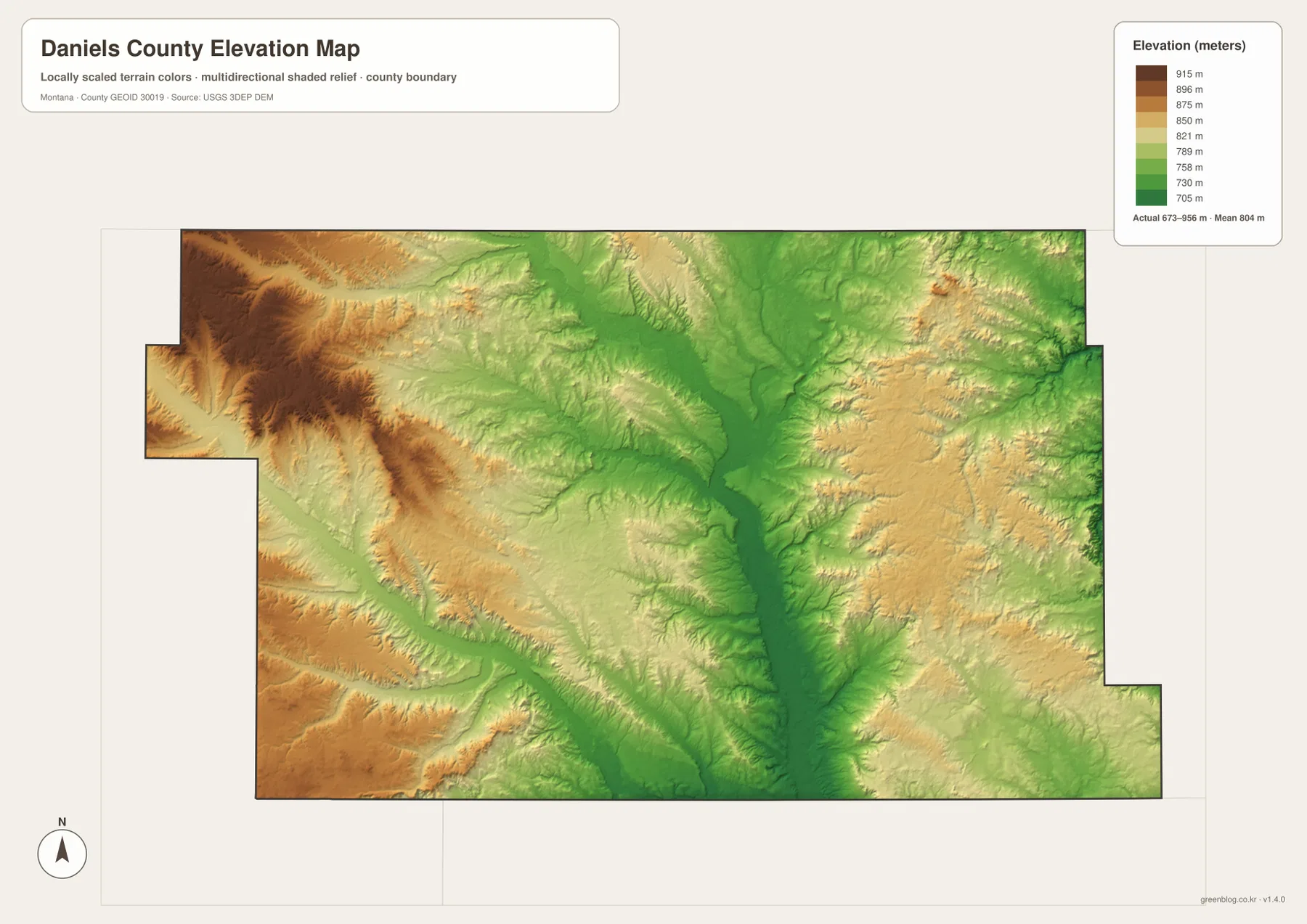
The West Fork Poplar River is the most useful water reference in southwestern Daniels County. It follows a long lower valley from the west and southwest toward the central Poplar River system. On the elevation map, the same corridor appears as a greener low strip between higher ridges, making the relationship between drainage and relief easy to see.
Hell Creek and Rattler Creek are labeled in the southwest, while Couley Creek approaches the Poplar River in the south-central area. Farther east, Eagle Creek and Prairie Creek cut separate shallow valleys. The number of small tributaries shows that the county is not a single flat surface even though much of it is open plains and farmland.
The USDA Natural Resources Conservation Service notes that Daniels County is drained mainly by the Poplar River and its Middle, East, and West forks. The supplied map shows that same structure clearly. In parts of the county where settlement labels are sparse, the forks provide better location cues than town names.
Elevation ranges from about 673 to 956 meters
The elevation map reports an actual range of about 673 to 956 meters, with a mean elevation near 804 meters. Lower terrain is shown in green, while higher uplands shift through yellow and brown. The overall vertical range is modest, but the contrast between the Poplar River valleys and the western uplands is still clear at county scale.
The strongest high terrain occupies the western and northwestern side. Brown ridges and closely spaced drainage cuts make that area look rougher than the center of the county. By contrast, the Poplar River forms a long green corridor from north to south, and the Middle and East forks are visible as lower branches feeding into it.
Eastern Daniels County is generally less elevated than the western high ground, though yellow uplands repeatedly rise between creek valleys. Eagle Creek and Prairie Creek occupy some of the lower cuts through this terrain. The elevation map is designed for county-wide comparison and should not be used as survey-grade, engineering-grade, or parcel-specific elevation data.
Scobey and the Poplar River forks make the county easier to navigate
A useful way to work through the map set is to begin at Scobey, then place Flaxville to the east, Peerless to the west, and Whitetail to the northeast. After that, switch to the water map and trace the Poplar River through the center. The Middle, East, and West forks divide the county into large natural sections that are easier to remember than dozens of minor roads.
Smaller features provide a second layer of detail. Paradise Pond, Outlook Creek, Eagle Creek, and Prairie Creek help distinguish the eastern side, while Coal Creek and Butte Creek are useful in the west. The West Fork Poplar River is especially helpful in the southwest because it remains visible both as a major drainage and as a low valley on the elevation map.
The WebP images embedded in the article are convenient for quick viewing. The high-resolution JPG files in the ZIP are better for printing or enlarging small road and creek labels. These are static reference maps, so changing conditions such as road access, stream levels, and local land restrictions should be checked through current official or local information.
Frequently Asked Questions
Does the city map show the distance between Scobey and Flaxville?
No. The city map shows the locations and ranking of Scobey and Flaxville but does not print a connector distance or driving mileage. For the actual route, use the general county map together with current navigation and road-condition information.
Where are the three major Poplar River forks on the map?
The Middle Fork Poplar River is in the north-central area, the East Fork approaches from the northeast, and the West Fork crosses the southwest. All three feed toward the central or southern Poplar River system shown on the terrain-and-water map.
Can the 673–956 meter elevation range be used for a property or engineering project?
No. The range is a county-wide reference for comparing lower river valleys with higher uplands. Precise site elevation should come from an authoritative source such as the USGS 3D Elevation Program and, when necessary, a professional survey.
Map File Information
Download the Daniels County county, city, terrain-and-water, and elevation maps as high-resolution A3 JPG files.
- Included Files: county map, city map, terrain and water map, elevation map
- File Type: ZIP containing 4 JPG files
Related Maps
Sources and References
County government and local background are available from the official Daniels County website. Natural-resource background on the Poplar River drainage is available from the USDA Natural Resources Conservation Service Daniels County page.
Boundary and road-reference data can be checked through U.S. Census Bureau TIGER/Line Shapefiles. Hydrographic reference data are available from USGS National Hydrography, and elevation data can be checked through the USGS 3D Elevation Program.
Green Map creates custom-edited map images using open geographic data sources such as geoBoundaries, Natural Earth, OpenStreetMap, and government open data. These maps are edited visual materials, not raw data files, and are provided for education, documents, presentations, and graphic reference.