Download the high-resolution JPG originals for this Teller County Map in the ZIP below. The maps show Woodland Park, Divide, Cripple Creek, and Victor, the main mountain-road corridors, Trout and West creeks, lakes and reservoirs, and a countywide elevation range that climbs sharply toward the west side of Pikes Peak. WebP versions are provided for quick browsing, while the full-size JPG files are better for printing, close inspection, and offline reference.
Teller County is easiest to understand as two main settlement areas connected across mountain terrain. Woodland Park anchors the northeastern side near U.S. 24, while Cripple Creek and Victor form a separate southern cluster associated with the historic mining district. Divide sits between those areas and works as a useful road reference point. Teller County’s official history identifies Cripple Creek as the county seat and Woodland Park as the county’s most populous city, which matches the different roles visible on the maps.
Table of Contents
Woodland Park, Divide, and the road network toward Cripple Creek
Woodland Park is the most prominent place on the northeastern side of the county map. U.S. 24 runs west from the Woodland Park area toward Divide and Florissant, while smaller roads branch through the mountain valleys around them. Green Mountain Falls appears southeast of Woodland Park, and places outside the county such as Cascade-Chipita Park and Manitou Springs help show the county’s position on the west side of the Pikes Peak region.
The southern part of the map has a different road pattern. Cripple Creek and Victor sit in steeper country where Colorado 67 and local routes bend through narrow valleys and ridges. Teller County’s history page connects this southern district with the 1890s gold boom and describes Woodland Park and Divide as important lumber, supply, and railroad communities that supported the mining region. On the modern map, that history is reflected in the separation between the northeastern population center and the southern mining towns, with Divide acting as a practical middle reference.
Straight-line distances from Woodland Park to the southern towns
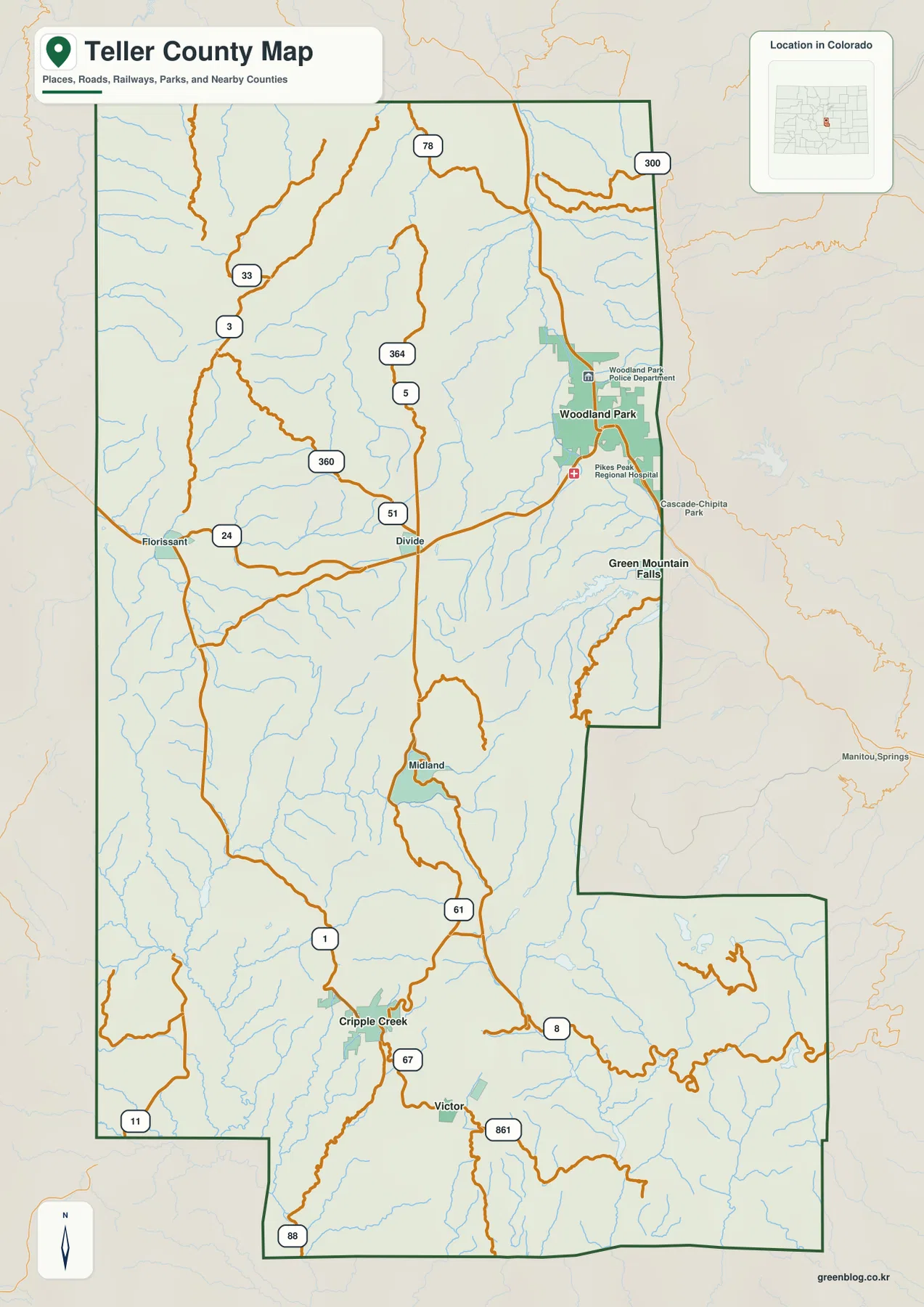
The city-connections map uses Woodland Park as the hub and shows Cripple Creek about 19 miles away and Victor about 20 miles away. These are direct straight-line distances, not road mileage or travel-time estimates. Mountain roads between the communities curve around ridges and valleys, so actual driving routes are longer than the point-to-point values shown on the map.
The map also shows how the settlement pattern is split. Woodland Park lies near the northeastern edge, while Cripple Creek and Victor form a much tighter pair in the south. Park County is labeled to the west, El Paso County to the east, and Fremont County to the southwest, helping place Teller County between the Pikes Peak urban side and the mountain country farther west and south.
Trout Creek, West Creek, lakes, and mountain reservoirs
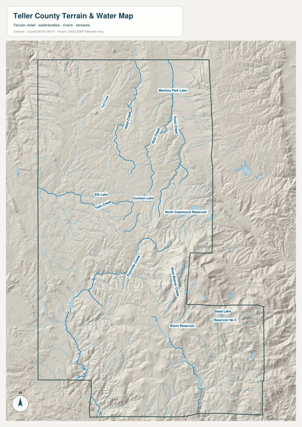
Trout Creek is one of the clearest named waterways in the northeastern part of the terrain and water map. West Creek runs through the neighboring mountain country, and Rule Creek descends between them. Manitou Park Lake provides a useful landmark in the northern part of the county. These streams are accompanied by many smaller tributaries, which gives the map a dense branching pattern typical of steep mountain drainage.
Near the middle of the county, Twin Creek crosses the terrain close to Elk Lake and Coulson Lake. North Catamount Reservoir is labeled farther east and stands out as one of the larger named water bodies on the map. Looking at these waters together with the elevation layer helps show how lakes and reservoirs occupy lower basins between ridges rather than broad flat plains.
Farther south, Fourmile Creek and West Beaver Creek follow separate mountain valleys, while Bison Reservoir, Dead Lake, and Reservoir No. 5 mark additional water features in the southern half of the county. Teller County does not have one single large river dominating the map; instead, its hydrology is a network of mountain creeks, small lakes, and reservoirs. This layer is for general geographic reference and should not be used as a flood-hazard map, water-rights document, legal channel boundary, or navigation chart.
Elevation from about 2,044 meters to nearly 4,000 meters
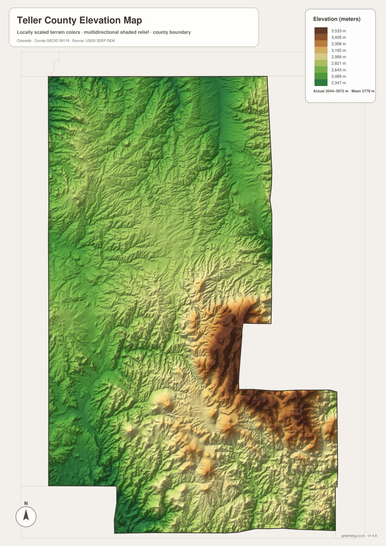
The elevation map reports an actual county range of about 2,044 to 3,972 meters, with a mean near 2,778 meters. Even the lower areas are high compared with many U.S. counties, but there is still substantial relief inside Teller County. Lower corridors appear across parts of the north and west, while Woodland Park and Divide occupy terrain that is lower than the steep Pikes Peak slopes to the east and southeast.
The highest terrain is concentrated along the western side of Pikes Peak and extends into the eastern and southeastern part of the county. Cripple Creek and Victor are also surrounded by rugged relief rather than broad level ground. When the water and elevation maps are compared, short tributaries can be seen descending from high ridges into lower valleys where roads and settlements have more room to fit.
Teller County’s official history page describes Woodland Park at roughly 8,000 feet and notes that the county reaches above 14,000 feet on the back side of Pikes Peak. That broad description is consistent with the map’s actual elevation range. The map is intended for countywide comparison, not survey-grade or engineering-grade measurement. Construction, land surveying, road design, or site-specific elevation work requires authoritative source data or professional measurements.
Reading Woodland Park and the Cripple Creek mining district as two different centers
Woodland Park and Cripple Creek play different geographic roles even though they are in the same county. Woodland Park sits on the U.S. 24 corridor that leads toward the Colorado Springs side of the Front Range, making it the clearest northeastern population and road hub. Cripple Creek and Victor form a southern mountain cluster tied to the historic gold district. Their roughly 19-to-20-mile straight-line separation from Woodland Park understates the effect of the mountain terrain on actual road travel.
Divide is the useful middle point for understanding the county as a whole. It lies on U.S. 24 between Woodland Park and Florissant and connects toward roads leading south. Teller County’s historical account also describes Divide as a railroad, lumber, and agricultural supply community during the growth of the Cripple Creek district. On the map, using Divide as a pivot makes the split between the northeastern corridor and the southern mining towns much easier to follow.
Which Teller County map should you open first?
Start with the county map when you need Woodland Park, Divide, Florissant, Cripple Creek, Victor, and the main road network in one view. Use the city-connections map when the question is how Cripple Creek and Victor are spaced from Woodland Park in straight-line terms. The water and terrain layer is the best choice for Trout Creek, West Creek, Twin Creek, Fourmile Creek, and the named lakes and reservoirs. The elevation map is most useful for comparing the lower valleys with the high Pikes Peak-side terrain.
For example, to understand a trip from Woodland Park toward Cripple Creek, compare the county and elevation maps first. Add the water layer to see the creek valleys that cut through the mountains. If you are looking at Divide, the county map provides the road context while the water and elevation layers explain the surrounding terrain. Switching maps by question gives a clearer answer than trying to read every feature from a single image.
Frequently Asked Questions
How far are Cripple Creek and Victor from Woodland Park on the city map?
The city-connections map shows Cripple Creek about 19 miles from Woodland Park and Victor about 20 miles away. Both values are straight-line distances, not road mileage or estimated driving time.
Which map is best for Trout Creek and North Catamount Reservoir?
The water and terrain map is the best choice. It shows Trout, West, Rule, Twin, Fourmile, and West Beaver creeks along with Manitou Park Lake, Elk Lake, Coulson Lake, North Catamount Reservoir, and other named water bodies.
Can the 2,044-to-3,972-meter elevation range be used for surveying?
No. The range is intended for broad geographic comparison across Teller County. Surveying, engineering, construction, or site-specific elevation work should use authoritative source data or professional survey measurements.
Map File Information
The ZIP contains the original high-resolution JPG versions of the county, city-connections, water/terrain, and elevation maps shown on this page. Use the larger files for printing, detailed viewing, or offline reference.
- Included Files: Use only the versions confirmed in the article and supplied images
- File Type: Use the confirmed download contents
- Intended Use: Printing, education, presentations, and map-based projects
Related Maps
Sources and references
- Teller County – Teller County History – county formation, Woodland Park, Divide, Cripple Creek, and the Pikes Peak setting
- Colorado Parks and Wildlife – Mueller State Park – mountain forest, meadow, and Pikes Peak regional context
- U.S. Census Bureau TIGER/Line Shapefiles – county boundaries, roads, and place reference
- USGS National Hydrography – streams, lakes, and reservoirs
- USGS 3D Elevation Program – elevation and terrain reference
Green Map creates custom-edited map images using open geographic data sources such as geoBoundaries, Natural Earth, OpenStreetMap, and government open data.
These maps are edited visual materials, not raw data files, and are provided for education, documents, presentations, and graphic reference.