Dawson County occupies a large section of eastern Montana, with Glendive in the southeastern interior and Richey much farther north. Glendive is the stronger road and river reference: I-94 and several numbered routes meet around the city, while the Yellowstone River passes through the same part of the county. Farther northwest, the Redwater River defines a second major low corridor. Between those two river systems, long ridges and branching creeks divide the county into a series of broad uplands and valleys. High-resolution JPG versions of the maps shown here are available together in the download ZIP below.
Montana Historical Society records Glendive as the county seat, and the maps make its central role easy to see. Richey is the only other ranked city on the supplied city view and sits far to the north. The terrain-and-water map adds major references such as Burns Creek, Thirteenmile Creek, and Upper Sevenmile Creek, while the elevation map shows why the Yellowstone valley looks so different from the higher country to the west. Starting with Glendive, Richey, and the two largest rivers gives a simple way to organize the county.
Table of Contents
Glendive is the main road reference in the southeastern interior
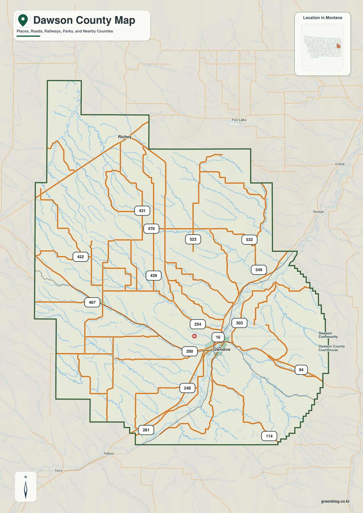
On the general county map, Glendive sits in the southeastern half close to the county’s strongest concentration of numbered roads. Route 16 runs north from the city, Highway 200 approaches from the west, and I-94 continues through the Glendive area toward the east. Routes 254, 303, 248, 261, and 114 are also labeled nearby, making this the easiest part of Dawson County to use as an orientation point.
The map also marks Dawson Community College and the Dawson County Courthouse east of the city center. North of Glendive, Route 16 leads toward roads 549, 532, and 523 before the map opens into the broad northern interior. Richey sits much farther north near another road junction. The county boundary itself is irregular, with a long northwestern projection and several stepped sections along the eastern and southeastern side.
In the west and southwest, routes 422 and 467 cross less densely settled country, while routes 431, 470, and 439 appear through the north-central and central interior. These road labels are useful for geographic reference, but the map is not a live navigation service. Surface conditions, construction, closures, and drive times can change, especially on local roads away from I-94.
The city map reduces Dawson County to Glendive and Richey
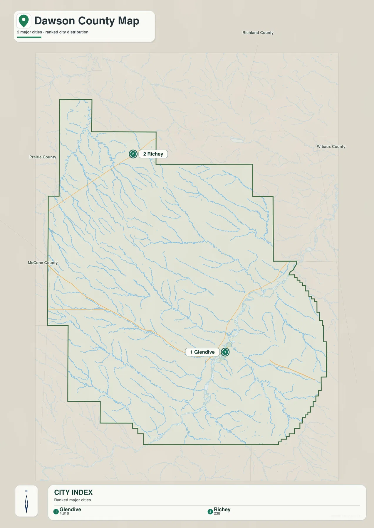
The city map ranks two places: Glendive and Richey. Its printed index lists Glendive at 4,810 and Richey at 238. Those figures are the values embedded in the supplied map and should not be treated as guaranteed current population estimates. For current demographic information, consult recent U.S. Census Bureau data.
The location pattern is more useful than the ranking itself. Glendive lies in the southeastern interior near the Yellowstone River corridor, while Richey is far to the north. Neighboring counties are labeled around the outside—Richland County to the north, Wibaux County to the east, Prairie County to the west, and McCone County along the western side—making it easier to place Dawson County within eastern Montana.
There is no connector line or mileage label between Glendive and Richey on this city map. The visual spacing should therefore be read only as a location reference, not as a straight-line or driving distance. An actual trip should be planned with the general county map and current navigation information.
The Yellowstone River forms the main low corridor around Glendive
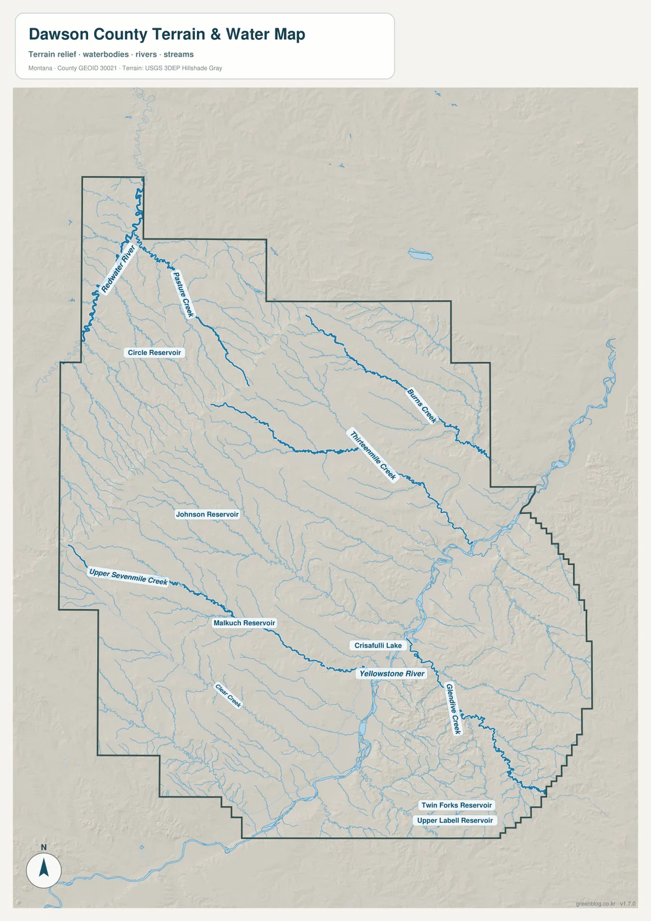
The terrain-and-water map makes the Yellowstone River the strongest feature in the southeastern half of Dawson County. The river enters from the southwest, passes through the Glendive area, and continues toward the northeast. Visit Montana describes Glendive as lying between the badlands and the Yellowstone River, which matches the supplied map’s close relationship between the city and the river corridor.
Glendive Creek is labeled southeast of the city area, while Burns Creek and Thirteenmile Creek cross the northern and northeastern interior. Upper Sevenmile Creek runs through the southwestern half. Several small water bodies provide additional local anchors, including Johnson Reservoir, Malkuch Reservoir, Crisafulli Lake, Twin Forks Reservoir, and Upper Labell Reservoir.
The Yellowstone valley appears broad and low compared with much of the surrounding upland. Numerous short tributaries cut down toward the river from both sides. This terrain-and-water map is intended for geographic reference; it is not a flood-hazard map, navigation chart, parcel survey, water-rights record, or guide to safe water access.
Redwater River gives the northwest its own strong water reference
The Redwater River stands out along the northwestern side of the county. It follows a separate low corridor from the Yellowstone and gathers many smaller tributaries from the surrounding uplands. Pairing Richey with the Redwater River is a useful way to orient the northern half before moving back toward the denser drainage network in the center.
Circle Reservoir is labeled southeast of the Redwater River corridor. Farther east, Burns Creek and Thirteenmile Creek cross the county toward the lower Yellowstone side. The number of branching tributaries between the two larger river corridors shows why Dawson County should not be imagined as a uniformly flat plain. Instead, broad uplands are repeatedly cut by shallow and deeper creek valleys.
Elevation ranges from about 601 to 1,058 meters
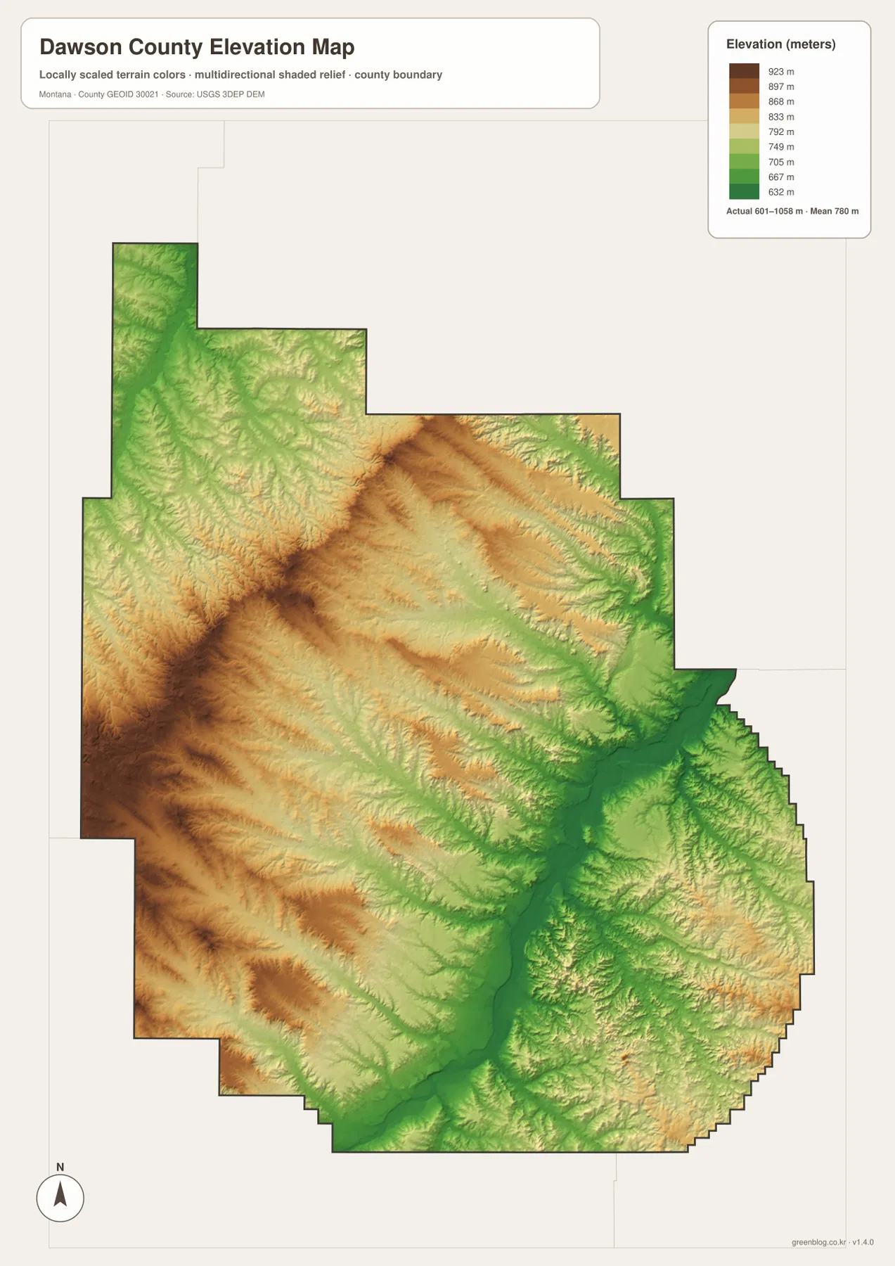
The elevation map reports an actual county range of about 601 to 1,058 meters, with a mean elevation near 780 meters. The lowest dark-green terrain follows the Yellowstone River corridor through the southeastern interior and also appears along the Redwater River in the northwest. Higher yellow and brown ground occupies much of the west and north-central interior.
A long elevated ridge stands out west of the county center, with numerous small valleys descending from it toward the Yellowstone side. Other uplands break up the northern interior between the Redwater and eastern creeks. When the elevation and water maps are compared, the relationship is straightforward: major rivers and larger creeks tend to occupy the lower green corridors, while the spaces between them rise into rolling or broken hills.
The eastern and southeastern edge also contains rolling relief, but the Yellowstone itself remains one of the county’s lowest continuous routes. Glendive sits close to that low river corridor. The elevation map is useful for county-wide comparison only and should not be used for surveying, engineering, construction, or determining the exact elevation of a specific property.
Glendive and Richey provide the simplest starting points for the map set
A practical way to use the maps is to begin with the two ranked cities. Glendive anchors the southeastern road network around I-94, Highway 200, and Route 16, while Richey provides a northern reference. Once those two points are fixed, routes 470, 439, and 523 help fill in the middle of the county without turning the map into a list of isolated road numbers.
Waterways provide the next layer. The Yellowstone River organizes the Glendive side, the Redwater River organizes the northwest, and Burns Creek, Thirteenmile Creek, and Upper Sevenmile Creek help divide the interior. Johnson Reservoir, Circle Reservoir, Crisafulli Lake, and the southeastern reservoirs are useful for finer location checks after the major river corridors are familiar.
The WebP images embedded in the article are convenient for quick browsing. The high-resolution JPG files in the ZIP are better for printing or enlarging smaller road, creek, and reservoir labels. Because these are static reference maps, changing conditions such as road closures, river levels, or land-access restrictions should be checked through current official or local information.
Frequently Asked Questions
Does the city map show the distance between Glendive and Richey?
No. The city map ranks and locates Glendive and Richey but does not print a connector distance or road mileage between them. Use the general county map and current navigation information for an actual trip.
Which rivers are the strongest geographic references in Dawson County?
The Yellowstone River is the main reference around Glendive and the southeastern interior, while the Redwater River provides a separate major reference in the northwest. Burns Creek and Thirteenmile Creek are also prominent named drainages between those larger corridors.
Can the 601–1,058 meter elevation range be used for a property or engineering project?
No. The range is intended for county-wide comparison between lower river valleys and higher uplands. Precise site elevations should come from an authoritative source such as the USGS 3D Elevation Program and, when necessary, a professional survey.
Map File Information
Download the Dawson County county, city, terrain-and-water, and elevation maps as high-resolution A3 JPG files.
- Included Files: county map, city map, terrain and water map, elevation map
- File Type: ZIP containing 4 JPG files
Related Maps
Sources and References
The Montana Historical Society county facts identifies Glendive as the Dawson County seat. Local context for Glendive and the Yellowstone River is available from Visit Montana and the Visit Glendive outdoor guide.
Boundary and road-reference data can be checked through U.S. Census Bureau TIGER/Line Shapefiles. Hydrographic reference data are available from USGS National Hydrography, and elevation data can be checked through the USGS 3D Elevation Program.
Green Map creates custom-edited map images using open geographic data sources such as geoBoundaries, Natural Earth, OpenStreetMap, and government open data. These maps are edited visual materials, not raw data files, and are provided for education, documents, presentations, and graphic reference.