Waseca County sits in southern Minnesota, with Waseca on the east-central side, Janesville to the northwest, Waldorf in the southwest, and New Richland near the southeast. The easiest road reference is the meeting of U.S. 14 and Minnesota Highway 13 at Waseca. This page pairs that road-and-town view with separate water and elevation maps, and the four high-resolution JPG originals can be downloaded together from the map file box below.
The county is not organized around one dominant river or one continuous urban strip. Little Le Sueur River winds across the middle, Le Sueur River becomes important in the southeast, and smaller creeks and lakes break up the rest of the landscape. The relief map adds another strong contrast: lower terrain is common across the west and northwest, while higher rolling ground becomes more prominent to the east and southeast. Reading those features together gives Waseca County a much clearer identity than a road list alone.
Table of Contents
U.S. 14 and Minnesota 13 make Waseca the clearest road reference
Waseca is the most useful starting point on the county map because U.S. 14 and Minnesota Highway 13 meet there. U.S. 14 crosses the county from west to east through the Waseca area, while Minnesota 13 comes north from the southern county line through New Richland before continuing beyond Waseca. MnDOT’s current Waseca County route records confirm both highways as major state-maintained corridors, so they provide a reliable framework for understanding the rest of the local road network.
Janesville lies northwest of Waseca and is shown about 11 miles away in straight-line distance. Its road pattern spreads west and north as well as back toward Waseca, so the town is not simply a point along the U.S. 14 corridor. New Richland, by contrast, fits directly into the north-south Minnesota 13 reference. Waldorf sits farther southwest and depends more on the local road grid, giving the southern half of the county two distinct town directions rather than one continuous line of settlement.
The general map also shows Minnesota 30, Minnesota 83, and numerous numbered county roads. South of Waseca, those roads form a fairly regular grid across agricultural country, while the northern and central parts bend more often around lakes, streams, and irregular drainage. The map is useful for regional orientation, but it is not a live traffic or construction map. Current closures, detours, and roadway conditions should be checked through MnDOT before travel.
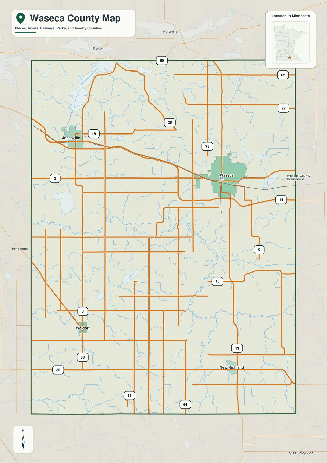
This county map is intended for broad geographic reference. It does not show parcel boundaries, legal property lines, or real-time road conditions. For ordinary orientation, begin with Waseca and U.S. 14, then place Janesville to the northwest and New Richland to the south. That simple frame makes the smaller road grid and outer county boundary much easier to follow.
Three nearby towns sit 11 to 14 straight-line miles from Waseca
The city-connections map uses Waseca as its hub and labels straight-line distances to Janesville, New Richland, and Waldorf. Janesville is shown at about 11 miles, New Richland at about 13 miles, and Waldorf at about 14 miles. These are direct point-to-point distances rather than driving distances, so actual trips may be longer depending on the road selected. The values work best as a quick way to compare direction and relative separation.
The same map includes reference population figures of 9,164 for Waseca, 2,378 for Janesville, 1,184 for New Richland, and 171 for Waldorf. Those numbers are best treated as map-reference values rather than a substitute for the latest official population estimates. Their useful role here is visual: Waseca clearly stands out as the largest of the four highlighted communities, while the other towns are smaller centers spread across different parts of the county.
The arrangement also explains why the county cannot be reduced to a single town corridor. Janesville sits northwest of the hub, New Richland lies south to southeast, and Waldorf is southwest. Each direction leads into a different road and drainage setting. The straight connector lines make the geometry easy to compare, but they are not roads. Anyone planning a drive should return to the general county map and follow the actual highway and county-road network.
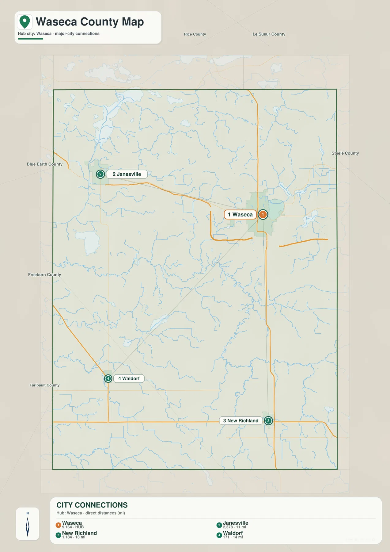
Because the lines are direct-distance connectors, the city map is strongest for answering questions such as which town is northwest of Waseca or which two places are roughly similar in distance from the hub. It should not be read as a route diagram. New Richland is most naturally understood with Minnesota 13, while Janesville and Waldorf require the surrounding road network shown on the general map.
Little Le Sueur River bends across the center before the larger southern drainage
Little Le Sueur River is the most visually continuous water feature across central Waseca County. It enters from the west, bends through the middle, and continues toward the eastern and southeastern drainage. Farther southeast, Le Sueur River becomes the larger named river. Looking at the two together shows that the county’s central lowland is not a single straight valley; it is a branching system with many small tributaries feeding larger channels.
Several smaller streams add structure to the southern half. Cobb River follows the southwest side, Little Cobb Creek and Bull Run Creek appear farther north, and Boot Creek feeds toward the Le Sueur River system in the southeast. These waterways line up with many of the lower green corridors on the elevation map. They are easy to overlook on the road map, but they explain why the surface is cut by repeated shallow valleys rather than forming one uniform plain.
Lakes are scattered rather than concentrated in one large lake district. Lake Elysian and Rice Lake appear toward the northwest, Reeds Lake is farther north-central, and Clear Lake and Goose Lake stand out east and northeast of Waseca. Buffalo Lake provides a western landmark, while Silver Lake is visible south of the central river corridor. Together they give the northern and central parts of the county more water features than a quick glance at the highway network might suggest.
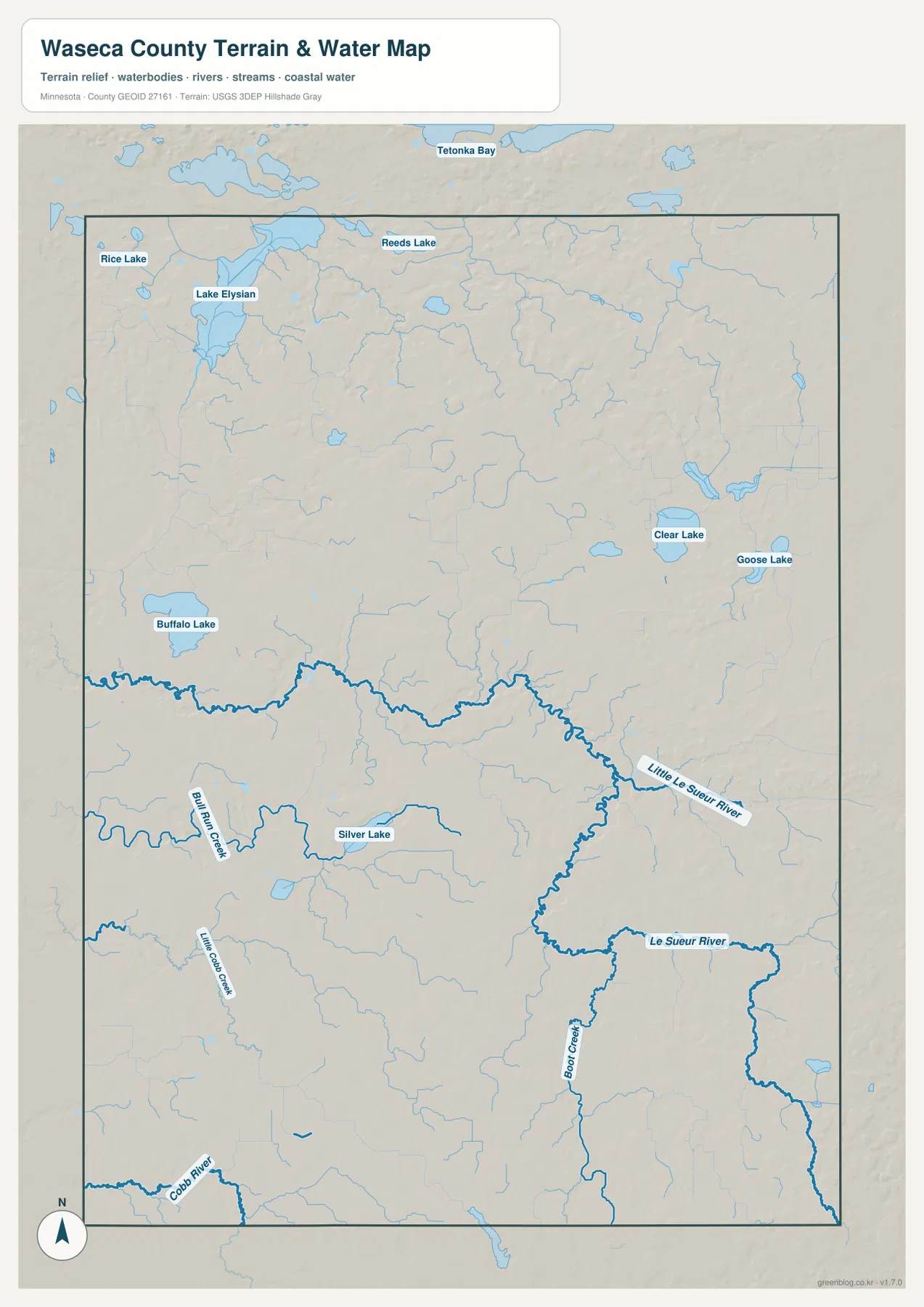
This is a geographic water-reference map, not a flood-risk, depth, water-quality, or navigation product. Stream conditions change with rainfall, season, and local management. For county orientation, its best use is to match towns and roads with nearby rivers, creeks, and lakes and to compare those channels with the lower areas shown on the elevation map.
A 302–395 meter range separates western low ground from eastern uplands
The elevation legend shows an actual range of roughly 302 to 395 meters, with a county mean near 339 meters. Broad green areas dominate much of the west and northwest, while yellow, orange, and brown terrain becomes increasingly common across the east and southeast. The total difference is less than 100 meters, but multidirectional shading reveals many short ridges and shallow valleys that make the relief more varied than a simple color gradient would imply.
The northwest lowland connects naturally with the Lake Elysian area, and the west-central part of the county also stays relatively subdued in color. A lower corridor follows Little Le Sueur River through the middle. East of that river, small uplands become much more frequent, and the southeast contains some of the strongest brown relief on the map. The pattern is therefore not a perfectly smooth west-to-east rise; stream valleys repeatedly cut lower paths through the higher eastern ground.
Comparing the elevation and water maps makes the relationship clearer. Little Le Sueur, Le Sueur, and Cobb river corridors occupy lower terrain, while rounded ridges between the channels rise above them. This explains why the southeast can be generally higher while still containing distinct low river valleys. It also helps place New Richland and the southern road grid within a landscape that alternates between gentle uplands and drainage cuts.
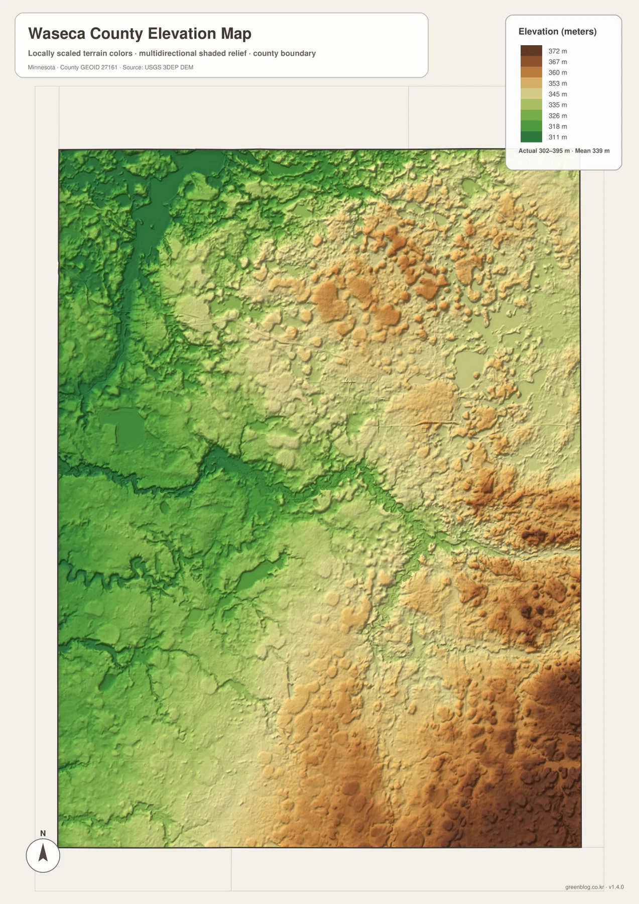
The elevation image is generalized for county-scale comparison. It should not be used to establish the precise elevation of a building lot, road grade, drainage structure, or engineering site. Surveying and design work require higher-resolution source data and field verification. Here the map is most useful for understanding the broad west-to-east contrast and the lower corridors followed by the county’s rivers and creeks.
A practical sequence for matching towns, roads, rivers, and relief
For a first pass, locate Waseca and the crossing of U.S. 14 with Minnesota 13. Then place Janesville northwest of the hub, New Richland to the south, and Waldorf to the southwest. The 11-to-14-mile direct distances on the city map make it clear that the four communities occupy a fairly compact area even though they point in different directions from Waseca.
Next, trace Little Le Sueur River across the middle of the county and look south toward Le Sueur River, Boot Creek, Cobb River, and Little Cobb Creek. When the same area is viewed on the elevation image, the river channels fall into lower corridors and the eastern side rises into more frequent hills. That sequence turns a flat-looking road map into a more complete picture of why the county’s towns, roads, lakes, and streams do not follow one simple geometric pattern.
The general map is the best choice when road labels and the county boundary matter most. The city-connections map is simpler for comparing the four highlighted communities and their direct distances. The water map isolates rivers, creeks, and named lakes, while the elevation map emphasizes the 302–395 meter relief and the higher eastern side. Selecting the map that matches the question keeps Waseca County’s distinct features visible instead of crowding everything into one layer.
Frequently Asked Questions
How far are Janesville and New Richland from Waseca on the city map?
The city-connections map shows about 11 straight-line miles from Waseca to Janesville and about 13 miles to New Richland. Waldorf is shown about 14 miles from Waseca. Those are direct distances, not driving mileage, so actual trips depend on the available roads.
Which waterways stand out most in Waseca County?
Little Le Sueur River is the most continuous central feature, while Le Sueur River becomes prominent in the southeast. Cobb River, Little Cobb Creek, Bull Run Creek, and Boot Creek add smaller southern channels. Named lakes include Clear Lake, Goose Lake, Buffalo Lake, Silver Lake, Lake Elysian, Rice Lake, and Reeds Lake.
Where is the highest terrain shown on the Waseca County elevation map?
The legend gives an actual range of about 302 to 395 meters and a mean near 339 meters. Higher terrain is concentrated mainly in the east and southeast, while the west and northwest are generally lower. River and creek valleys interrupt that broad trend with lower corridors through the uplands.
Map File Information
The ZIP contains high-resolution JPG originals of the Waseca County general map, city-connections map, water map, and elevation map shown on this page.
- Included Files: 4 high-resolution JPG maps
Related Maps
Sources and references
- Minnesota Department of Transportation Waseca County General Highway Map — county roads and major routes
- U.S. Census Bureau TIGER/Line Shapefiles — county boundaries and geographic reference data
- USGS National Hydrography — rivers, streams, and water features
- USGS 3D Elevation Program — elevation and terrain reference data
Green Map creates custom-edited map images using open geographic data sources such as geoBoundaries, Natural Earth, OpenStreetMap, and government open data. These maps are edited visual materials, not raw data files, and are provided for education, documents, presentations, and graphic reference.