Missaukee County sits in the northern Lower Peninsula of Michigan, with Lake City serving as the county seat and the main reference point for the roads and waterways shown here. M-55 crosses the county through Lake City, while M-66 runs north-south and continues toward McBain. Lake Missaukee lies immediately west of Lake City, and the eastern half of the county is crossed by branches of the Muskegon River system. The maps on this page can also be downloaded as high-resolution JPG files in a ZIP for closer viewing or printing. High-resolution map files are available for download in the section below.
The county becomes easier to understand when several features are matched to the same places. Lake City marks the junction of the two most visible state highways, McBain provides a southern and western reference, and Lake Missaukee anchors a cluster of smaller lakes. Farther east, the West Branch Muskegon River and other streams cross lower terrain. The elevation sheet adds another layer, showing an actual range of about 286 to 471 meters, with prominent high ground in the north-central and southwestern parts of the county and broader lower terrain to the east.
Table of Contents
Lake City and the M-55–M-66 junction provide the clearest starting point
On the general county map, Lake City is the easiest place to locate first. M-55 runs east and west through the community, while M-66 approaches from the north and continues south toward McBain. Lake Missaukee sits just west of the city, making the lake, the road junction, and the county seat a compact group of landmarks. Falmouth appears farther south and east, while Jennings is labeled west of Lake Missaukee. These names give the western half of the county enough reference points to understand where the principal roads and water features lie.
The outer county boundary is fairly simple compared with the network inside it. M-55 creates a long east-west reference across the middle of the county, and M-66 provides the stronger north-south line around Lake City and McBain. Smaller roads and streams become denser in portions of the west and southwest, while the Muskegon River system becomes more prominent toward the east. For a county-wide overview, it is useful to establish Lake City first and then add roads, water, and terrain instead of trying to identify every small label at once.
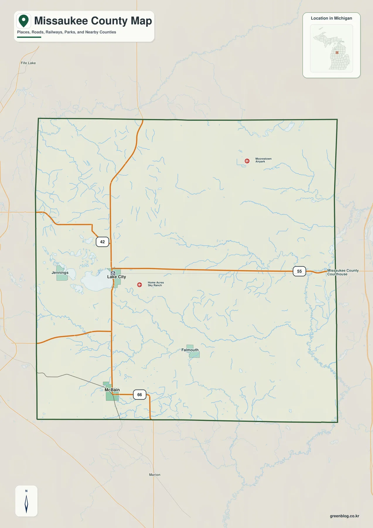
This sheet is designed for geographic orientation rather than turn-by-turn travel. It does not show live road closures, construction, winter driving conditions, or current travel times. Its strength is the ability to explain broad relationships at a glance: Lake City sits at the highway junction, McBain is reached to the south, Lake Missaukee is immediately west of the county seat, and the eastern side contains a more visible network of river channels. Current transportation information should be checked separately when planning an actual trip.
The city index reduces the county to Lake City and McBain for a quick orientation
The city-index map highlights two places: Lake City and McBain. Removing much of the surrounding detail makes their relative positions especially easy to remember. Lake City lies in the west-central part of the county, while McBain is farther south and closer to the western edge. Lake City is also the county seat, so it works well as the first reference point for local government, the main lake, and the highway junction. McBain provides a clear second anchor for the southwestern part of the county.
Once those two positions are familiar, the general road map is much easier to read. M-66 links the Lake City area with McBain, and M-55 crosses Lake City from east to west. The city symbols should not be treated as exact municipal boundaries; they are representative locations intended for orientation. Anyone who needs precise city limits, township boundaries, parcels, or legal descriptions should use the county GIS and official boundary data rather than the simplified city-index sheet.
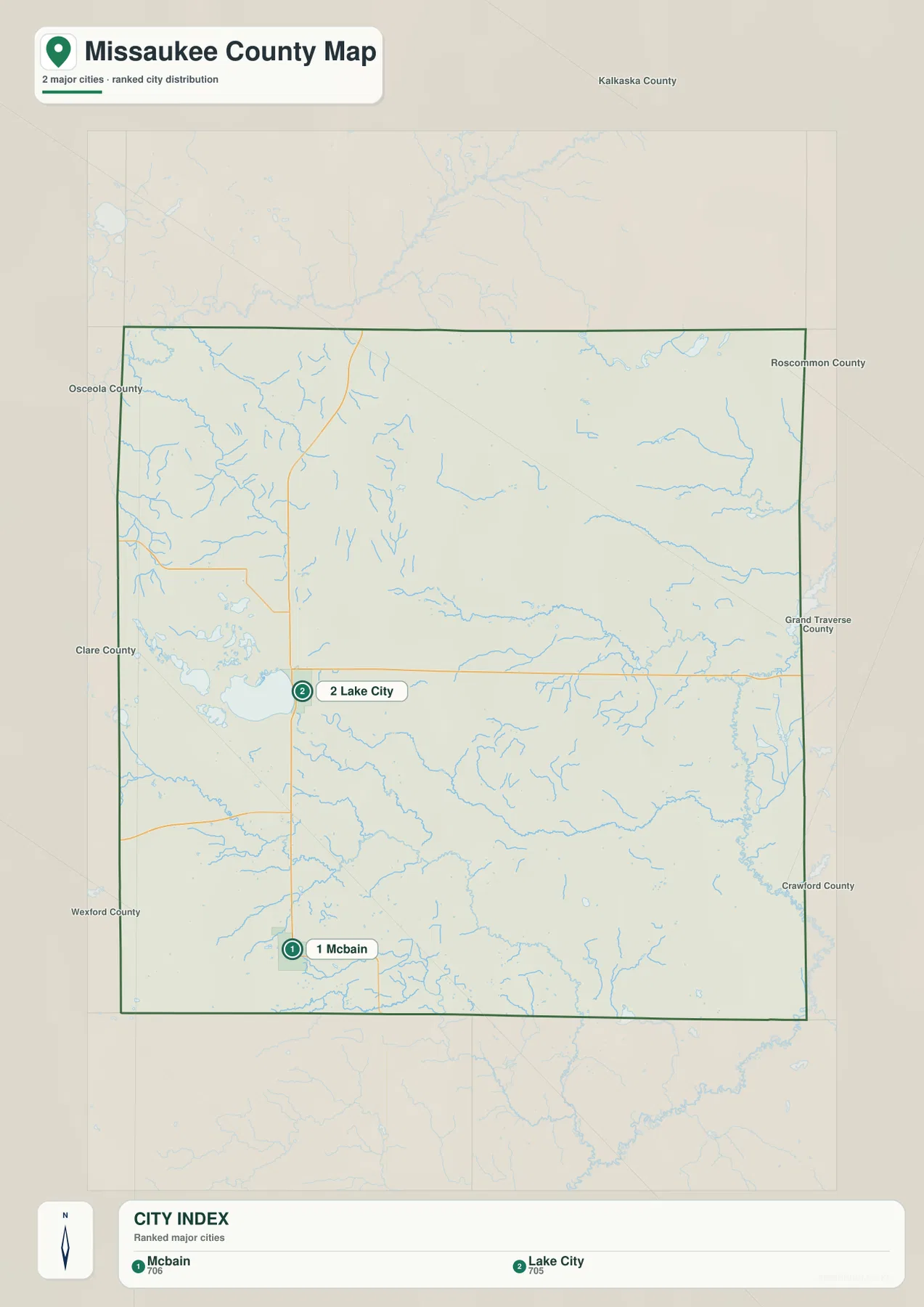
A useful learning sequence is to memorize the two city positions first, then return to the county map and add the highways. From Lake City, follow M-66 south toward McBain and M-55 in both directions across the county. After that, the water map can be matched to the same places, with Lake Missaukee next to Lake City and the Muskegon River system farther east. This step-by-step approach keeps the smaller labels from overwhelming the larger geographic pattern.
Lake Missaukee anchors a western lake cluster while the Muskegon River system crosses the east
Lake Missaukee is the largest and most obvious named lake on the water sheet. Several smaller lakes are grouped nearby, including Dyer Lake, Long Lake, Crooked Lake, Sapphire Lake, and Whitlock Lake. Together they make the Lake City side of the county visually different from the river-dominated east. Grass Lake is labeled in the northeast, while Cranberry Lake appears near the southeastern edge, so the county’s named lakes are not limited to the Lake Missaukee cluster.
Across the central and eastern portions of the county, flowing water becomes the stronger feature. The West Branch Muskegon River runs eastward through the county and receives a number of smaller tributaries before reaching the broader Muskegon River system near the eastern side. Butterfield Creek forms a long channel across the southern half. In the southwest, the Clam River and North Branch Clam River create another distinct set of waterways, and Hopkins Creek is labeled in the northwest. These separate river and lake areas show that Missaukee County is divided among several drainage corridors rather than organized around a single lake or stream.
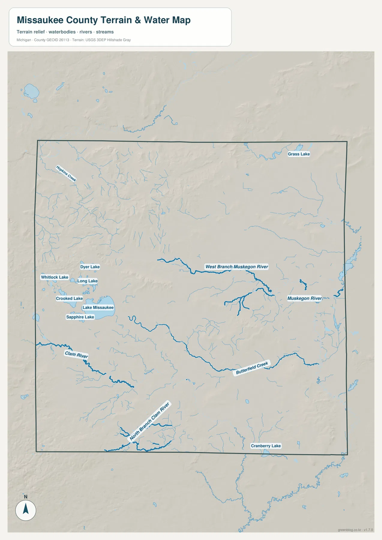
The water sheet is a location reference, not a live hydrology or recreation-safety product. It does not report current lake levels, streamflow, flood risk, water depth, boating hazards, or fishing rules. Michigan DNR provides county-specific inland lake resources, and the USGS maintains more detailed hydrography data. Use this map to identify where the named lakes and streams lie in relation to Lake City, McBain, and the county boundary, then consult current agency information for decisions that depend on present conditions.
Elevation spans about 286–471 meters, with rugged high ground north-central and southwest
The elevation map reports an actual range of roughly 286 to 471 meters and a mean near 369 meters. Its strongest brown and tan colors appear in a rugged north-central area and again near the southwestern corner. A long elevated band also stands out across part of the southern interior. In contrast, much of the eastern side is green, indicating lower terrain within the county’s local color scale. The change is substantial enough that the county does not read as one broad, even plain.
Water and relief line up in useful ways. Stream corridors cut lower bands through the surrounding uplands, and the central-to-eastern river system occupies gentler, lower terrain than several of the nearby ridges. The Lake Missaukee area is less elevated than the most pronounced high ground to the north and southwest, although the terrain around the lake is not perfectly flat. Comparing the elevation and water sheets side by side helps explain why some streams follow obvious low corridors while the higher areas remain broken into ridges and rounded hills.
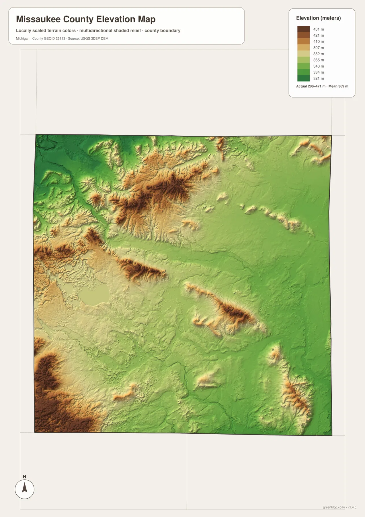
The colors are locally scaled to make relative height differences visible within Missaukee County. Brown does not automatically mean steep mountain terrain, and green does not automatically indicate a wetland or floodplain. Parcel elevations, drainage grades, construction design, and flood-related decisions require more detailed source data and, when appropriate, professional surveying. For general reference, the sheet is best used to compare the county’s higher ridges with the lower river corridors and eastern lowlands.
A simple map-reading sequence connects roads, lakes, rivers, and relief
Start with Lake City on the general map and locate the crossing of M-55 and M-66. Next, move west to Lake Missaukee and south along M-66 toward McBain. On the water map, match the same Lake City–Lake Missaukee area, then follow the West Branch Muskegon River from the middle of the county toward the east. The Clam River and Butterfield Creek add southern references, while the smaller western lakes help distinguish the Lake Missaukee side of the county from the river-heavy eastern side.
Finally, open the elevation sheet and compare those same locations. The north-central and southwestern high ground stands out clearly against lower eastern terrain, while the river corridors create lower pathways through the relief. This method is useful for classroom geography, county introductions, local-history notes, and personal study because it links visible place names to physical features rather than treating each map as a separate illustration.
Using the high-resolution JPG files for printing and closer study
The WebP images displayed in the article are reduced for convenient web viewing. The downloadable ZIP contains 2572 × 3638 pixel JPG originals of the same four map subjects, making it easier to zoom in on road shields, lake labels, stream names, and smaller geographic details. The general county map works well for place-and-road orientation, the city index simplifies Lake City and McBain, the terrain-and-water sheet emphasizes named waters, and the elevation sheet is the clearest choice for comparing higher and lower terrain.
These files are general reference maps rather than legal, engineering, emergency, or navigation products. Exact administrative boundaries should be checked against Missaukee County GIS or Census geographic data. Detailed hydrography and elevation work should use current USGS source data. That distinction matters for parcel research, flood analysis, construction, road design, or other tasks where a county-scale illustration cannot provide the necessary precision.
Frequently Asked Questions
Which map is easiest for comparing Lake City and McBain?
The city-index map is the simplest choice because it emphasizes only the two cities and their relative positions. Lake City is the west-central reference point, while McBain lies farther south and west. Use the general county map next if you also want M-55, M-66, Lake Missaukee, and surrounding roads.
What lakes and rivers are labeled besides Lake Missaukee?
The water map labels Dyer Lake, Long Lake, Crooked Lake, Sapphire Lake, Whitlock Lake, Grass Lake, and Cranberry Lake. Named flowing waters include the West Branch Muskegon River, Muskegon River, Clam River, North Branch Clam River, Butterfield Creek, and Hopkins Creek.
Can the 286–471 meter elevation map be used for parcel or construction work?
No. It is a county-scale reference for comparing relatively high and low terrain. Parcel elevations, drainage grades, engineering design, and flood decisions require more detailed official data and, when necessary, professional surveying.
Map File Information
The ZIP includes high-resolution JPG originals of the general county map, city-index map, terrain-and-water map, and elevation map. They are better suited to zooming and printing than the reduced WebP images used in the article.
- Included Files: Use only the versions confirmed in the article and supplied images
- File Type: Use the confirmed download contents
- Intended Use: Printing, education, presentations, and map-based projects
Related Maps
Sources and references
- Missaukee County official website: county government, GIS, parks, and local public resources.
- Library of Michigan – Missaukee County Guide: county background, Lake City county-seat information, and historical resources.
- Michigan DNR – Missaukee County Inland Lake Maps: county-specific inland lake references, including Lake Missaukee and nearby lakes.
- U.S. Census Bureau TIGER/Line Shapefiles: official boundary and road geography.
- USGS National Hydrography: official river, stream, and waterbody data.
- USGS 3D Elevation Program: official elevation and terrain data.
Green Map creates custom-edited map images using open geographic data sources such as geoBoundaries, Natural Earth, OpenStreetMap, and government open data. These maps are edited visual materials, not raw data files, and are provided for education, documents, presentations, and graphic reference.