Midland County sits in the central part of Michigan’s Lower Peninsula, with the city of Midland near the eastern side of the county and Sanford and Coleman extending the main settlement pattern toward the northwest and west. US-10 is the easiest road to follow between those places, while M-20 crosses the county through Midland and M-30 provides a north–south reference near Sanford. This page connects those roads and communities with the Tittabawassee and Chippewa river systems and the county’s modest but visible elevation changes. High-resolution JPG versions of the supplied maps are also available in the download box below.
The county is especially easy to understand when roads and water are read together. The Tittabawassee River runs through the central part of the map, passes Sanford Lake, and bends toward Midland. Farther south, the Chippewa River and Pine River cross lower ground on their way toward the Midland area. The elevation sheet adds a useful third layer: river corridors around Midland and Sanford are lower, while the northwest rises into the highest part of the county. Those relationships make the map set useful for general orientation, classroom work, regional reference, and printable study materials.
Table of Contents
US-10 ties Midland, Sanford, and Coleman into one easy geographic reference
The general county map places Midland close to the eastern side of the county, where a large urban area stands out from the more lightly developed interior. US-10 runs northwest from the Midland area toward Sanford and Coleman, making it the clearest road for organizing the three best-known labels on the supplied maps. M-20 crosses Midland from east to west and continues across the southern half of the county, while M-30 passes near Sanford in a north–south direction. M-18 appears farther west and provides another useful reference around Coleman and the western interior.
The county boundary is not a simple rectangle. A step in the northern edge creates a raised section near the middle, and the southern boundary has another offset. These changes matter when following roads and streams near the edge because they explain why some features enter or leave the county at unexpected places. Midland is close to the eastern boundary, Coleman is close to the western side, and Sanford sits between them near the Tittabawassee River. Together, the three places span much of the county from east to west.
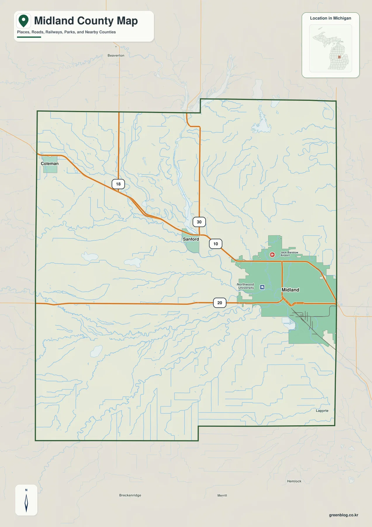
This sheet is best used for county-scale orientation rather than turn-by-turn navigation. It can quickly answer where a community sits relative to a major highway, where Midland lies within the county outline, or which main route approaches Sanford. It does not provide current road closures, construction notices, lane details, or travel times. For driving decisions, use current Michigan transportation information and navigation data. For studying the county’s basic layout, however, the road labels and simplified urban areas are more useful than a dense street map.
The city-connection view reduces the county to three memorable place anchors
The city-connection map emphasizes Midland, Coleman, and Sanford. Removing much of the secondary detail makes their relationship immediately clear: Midland is the eastern anchor, Sanford lies northwest of it, and Coleman sits farther west. The pattern follows the same general direction as US-10, so a reader who remembers the road can also remember the order of the places. This is particularly helpful for someone encountering Midland County for the first time and wanting a simple mental picture before looking at rivers, smaller roads, or the full boundary.
The symbols on this sheet represent selected place locations rather than the complete legal limits of each municipality. They should not be used to judge municipal area, annexation boundaries, or exact driving mileage. Instead, the map works as an index. Start at Midland, move northwest toward Sanford, and continue west toward Coleman; then return to the general map to add US-10, M-30, M-20, and the smaller surrounding roads. That two-step approach is often easier than trying to learn every road and stream at once.
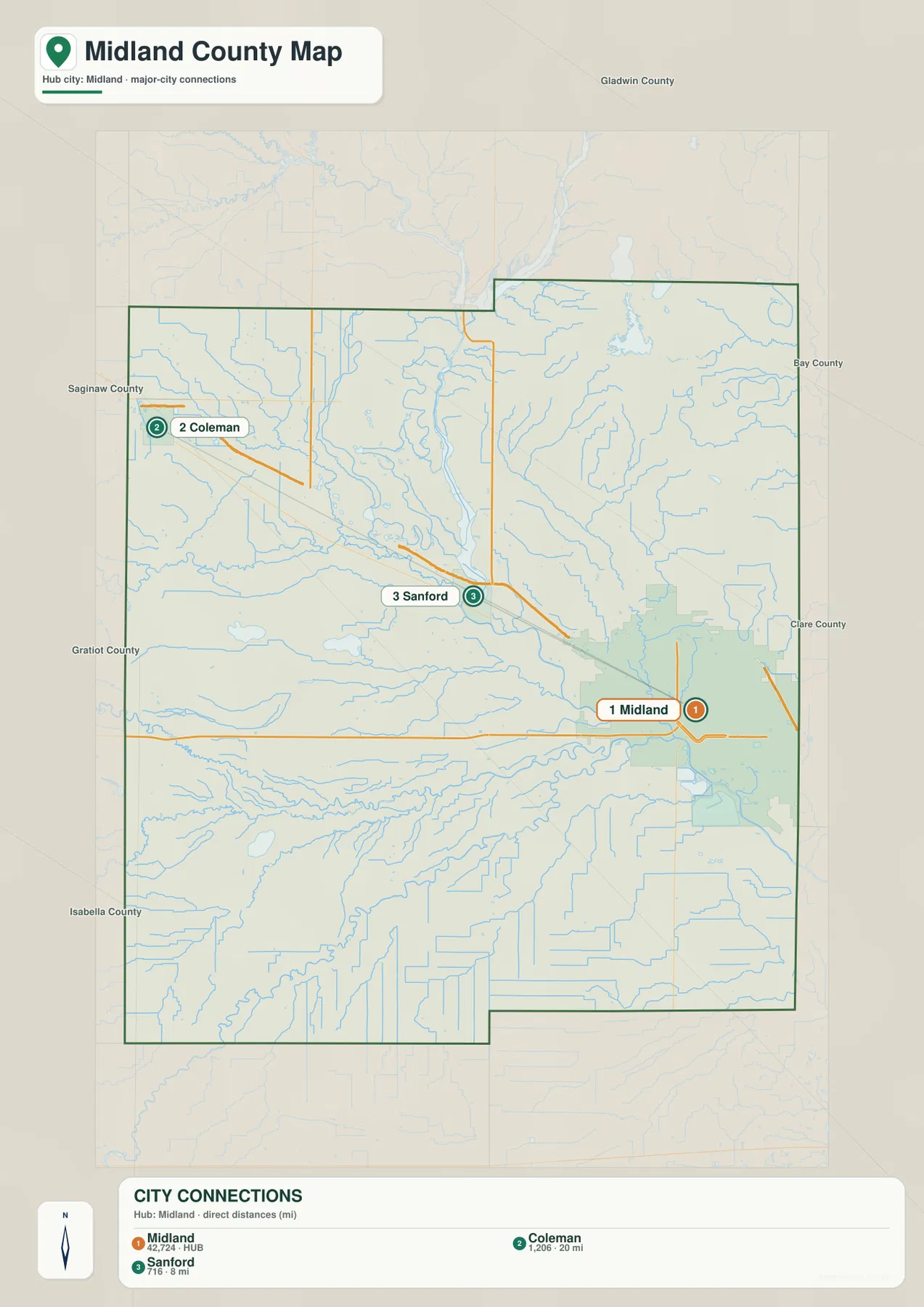
The simplified view also highlights how different the county is from a single compact urban district. Midland occupies a prominent eastern position, but large stretches of the county extend west and north through river valleys, smaller communities, and rural roads. Sanford is useful as a central reference because it sits close to both US-10 and the Tittabawassee River. Coleman, farther west, gives the map a second edge reference and makes the county’s east–west span easier to visualize.
The Tittabawassee River, Sanford Lake, and southern tributaries organize the water map
The Tittabawassee River is the strongest water feature on the supplied terrain-and-water sheet. It enters from the north, runs through the central part of the county, passes Sanford Lake, and continues toward Midland. The Tobacco River is labeled north of Sanford Lake, while several smaller tributaries join the larger system nearby. This gives the central county a branching pattern of waterways rather than one isolated river channel.
Western Midland County contains additional named streams, including the Salt River and Bluff Creek. Farther south, the Little Salt River and Little Salt Creek extend across the lower portion of the map. The southeastern half is organized around the Chippewa River and Pine River, with Sturgeon Creek nearby. In the northeast, the Kawkawlin River forms a separate named corridor. Looking at all of them together shows that Midland County contains several river systems and tributaries rather than a single drainage line crossing from one side to the other.
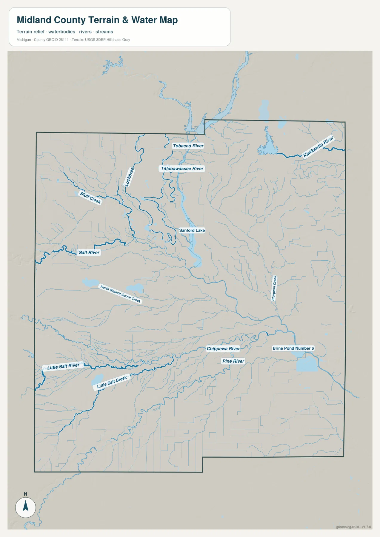
The water map is intended for geographic reference, not for current hydraulic or safety decisions. It does not show live streamflow, reservoir operating conditions, flood probability, regulated wetland boundaries, water depth, or safe boating routes. Those questions require current information from the USGS and the appropriate Michigan or local agencies. For general study, use the map to locate the major named rivers and compare how they pass through the county’s road and settlement pattern.
Elevation ranges from about 180 to 235 meters, with the highest ground toward the northwest
The elevation map reports an actual range of approximately 180 to 235 meters and a mean near 203 meters. The darkest brown and tan areas appear in the northwest, showing the highest broad terrain within the county. Lower green zones follow the Tittabawassee River corridor and expand around the Midland area. When the elevation and water sheets are viewed side by side, the relationship between the main river valleys and the lower terrain becomes much easier to recognize.
The west is not uniformly high. Stream valleys cut lower bands through the uplands, while smaller rises occur between them. The eastern and northeastern parts of the county also mix low drainage corridors with somewhat higher ground, but they generally lack the broad high colors found in the northwest. The most useful summary is therefore a contrast rather than a precise slope: Midland and the major river corridors occupy lower terrain, while land rises toward the western and northwestern side of the county.
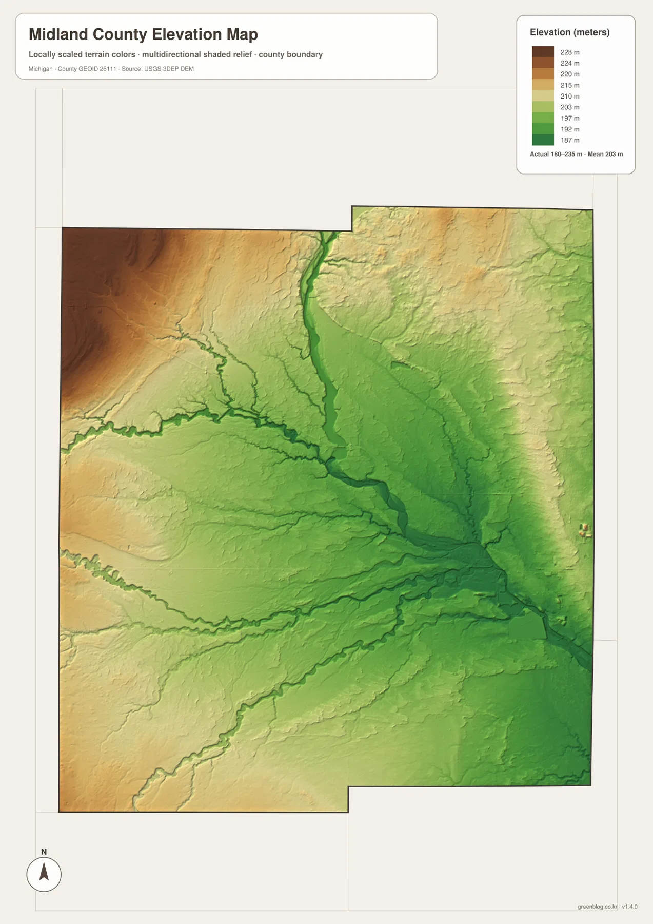
The color ramp is locally scaled for broad comparison inside Midland County. A brown area should not automatically be described as mountainous, and a green area does not by itself indicate flood hazard. Site elevations, drainage grades, construction design, and parcel-level flood decisions require more detailed source data and, when appropriate, professional surveying. The map is most useful for explaining why the river corridors appear lower and why the western side of the county shows more elevated terrain.
Reading roads, rivers, and relief together gives Midland County a clear east-to-west structure
A practical way to study the county is to begin in Midland, follow US-10 northwest to Sanford, and continue toward Coleman. Then locate M-20 through Midland and M-30 near Sanford to establish the main road directions. Once that framework is familiar, switch to the water sheet and match Sanford Lake and the Tittabawassee River to the same locations. The Chippewa River adds a southern reference, while the elevation map shows how those waterways occupy lower ground than much of the northwest.
Each map is strongest for a different task. The general county sheet combines roads, place names, and the outer boundary. The city-connection view makes the three principal place labels easy to remember. The terrain-and-water sheet is better when river and creek names matter, and the elevation sheet explains the relative difference between uplands and river valleys. Comparing the same location on two or more sheets gives a more complete picture than asking one map to provide every type of detail.
Using the high-resolution files for printing, study, and local reference
The WebP images in the article are reduced for convenient on-page viewing. The downloadable ZIP contains high-resolution JPG originals at 2572 × 3638 pixels, which makes it easier to zoom in on road shields, stream names, and smaller map labels or to place the maps into printed study material. A classroom handout might pair the general county map with the water map, while a regional geography note can add the elevation sheet to explain the difference between the northwestern uplands and the lower Midland river area.
These files are general reference maps rather than legal, engineering, emergency, or navigation products. Use Midland County GIS or Census geographic data when exact administrative boundaries matter. For detailed hydrography and elevation work, consult current USGS source data. That distinction is especially important if a project concerns parcel boundaries, flood risk, reservoir conditions, construction grades, or other decisions where a county-scale illustration is not precise enough.
Frequently Asked Questions
Which map is easiest for comparing Midland, Sanford, and Coleman?
The city-connection map is the simplest option when you only need the relative positions of the three places. Midland is the eastern anchor, Sanford lies northwest, and Coleman is farther west. Use the general county map next if you also want to see US-10, M-20, M-30, and surrounding roads.
Where are the Tittabawassee and Chippewa rivers shown?
On the terrain-and-water map, the Tittabawassee River runs through the central county, passes Sanford Lake, and continues toward Midland. The Chippewa River crosses the southern part of the county toward the Midland area. The same sheet also labels the Pine, Salt, Tobacco, and Kawkawlin river areas.
Can the 180–235 meter elevation map be used for flood or construction decisions?
No. The elevation map is a county-scale reference for comparing relatively high and low terrain. Parcel elevations, flood hazards, drainage grades, and engineering design require more detailed official data and, when necessary, professional surveying.
Map File Information
The ZIP includes high-resolution JPG originals of the general county map, city-connection map, terrain-and-water map, and elevation map. They are better suited to zooming and printing than the reduced WebP images used in the article.
- Included Files: Use only the versions confirmed in the article and supplied images
- File Type: Use the confirmed download contents
- Intended Use: Printing, education, presentations, and map-based projects
Related Maps
Sources and references
- Midland County official website: county information, public services, recreation, and local resources.
- Midland County GIS: public GIS, mapping, and property-related geographic resources.
- U.S. Census Bureau TIGER/Line Shapefiles: official boundary and road geography.
- USGS National Hydrography: official river, stream, and waterbody data.
- USGS 3D Elevation Program: official elevation and terrain data.
Green Map creates custom-edited map images using open geographic data sources such as geoBoundaries, Natural Earth, OpenStreetMap, and government open data. These maps are edited visual materials, not raw data files, and are provided for education, documents, presentations, and graphic reference.