Lapeer County occupies a part of Michigan’s eastern Lower Peninsula where several small communities are tied together by a few easily recognized roads. Lapeer, the county seat, sits at the meeting of M-24 and the I-69 corridor; Imlay City lies farther east near M-53; and North Branch provides a separate northern reference along M-90. Those road anchors are useful because the county is not organized around one single urban center. The supplied maps also show a second layer of geography: the Flint River system dominates much of the northwestern and central interior, the Belle River system appears in the southeast, and the strongest uplands are concentrated toward the southern edge.
The maps embedded on this page are convenient WebP previews, while the downloadable ZIP contains the matching high-resolution JPG files for closer viewing and printing. Rather than treating the four sheets as separate illustrations, it helps to move from one familiar place to the next. Start with Lapeer and Imlay City, use the roads to establish direction, then compare the city distribution, waterways, lakes, and elevation. That sequence makes it much easier to see why the western and northern parts of the county feel different from the southeastern side.
Table of Contents
Lapeer and Imlay City define the county’s clearest southern route
On the general county map, Lapeer is the most useful place to locate first. M-24 runs north and south through the city, while I-69 crosses the southern portion of the county from west to east. Once that junction is fixed in mind, other places fall into position quickly. Following I-69 east leads through the Attica area toward Imlay City. Following M-24 north points toward Barnes Lake and the North Branch area, while the same highway continues south toward Metamora. The map therefore gives Lapeer a practical role as an orientation point even before any detailed water or elevation information is added.
Imlay City forms a second southern anchor. It lies near the eastern side of the county where I-69 meets the M-53 corridor. M-53 continues south toward Almont and north along the eastern side, so the two larger southern communities connect to different north-south highways even though both sit along the same east-west interstate. That arrangement is one of the easiest ways to remember the county. Think of Lapeer as the M-24 reference and Imlay City as the M-53 reference, with I-69 linking the two across the lower part of the map.
North Branch adds a very different reference farther north. M-90 runs through the community from west to east and approaches M-24 on the western side. Columbiaville appears well to the west, Clifford is near the northern edge, and Otter Lake is close to the western boundary. Dryden and Almont are grouped much farther south and east. These places show why a single “downtown-to-suburbs” model does not describe Lapeer County very well: several small communities occupy different road, lake, and stream settings.
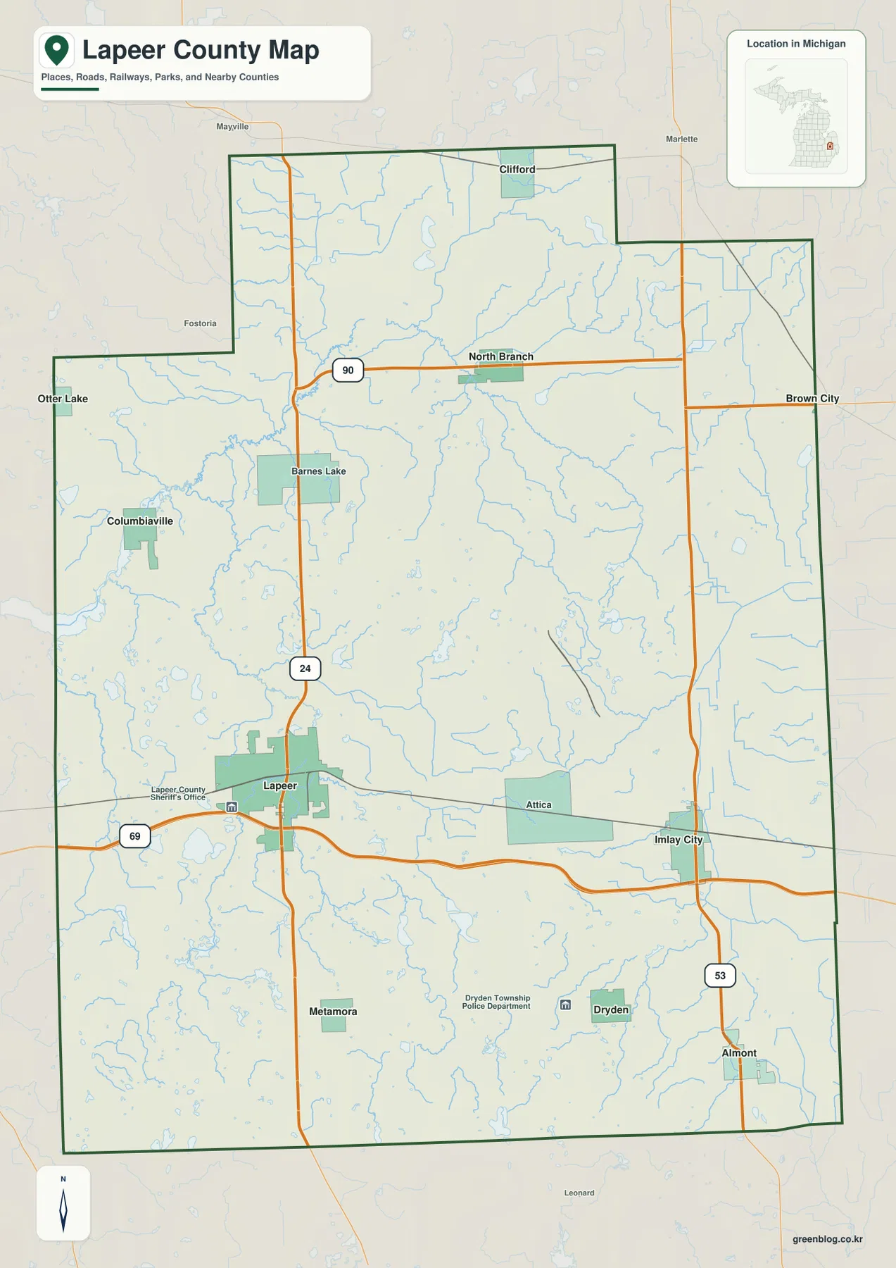
The county outline itself is also useful for orientation. Its northwestern and northeastern steps make the boundary more irregular than a simple rectangle, so communities near the edge stand out clearly. Labels outside the boundary, including places such as Mayville, Marlette, and Brown City, provide additional regional context. Those outside references can help a reader understand which side of the county a route approaches, but the sheet should still be treated as a general geographic reference. Parcel limits, legal boundary determinations, construction closures, and current turn-by-turn navigation require the appropriate official sources.
Six highlighted communities reveal a spread-out settlement pattern
The city distribution map reduces much of the highway detail and emphasizes six communities: Lapeer, Imlay City, Almont, Dryden, North Branch, and Columbiaville. Lapeer is ranked first on the supplied index and Imlay City second, followed by Almont, Dryden, North Branch, and Columbiaville. The pattern matters more than the ranking itself. The first two places occupy separate nodes in the southern half of the county, Almont and Dryden form a southeastern pair, North Branch stands well to the north, and Columbiaville provides a western point of reference.
Seen this way, the county does not look like one continuous built-up strip. Lapeer and Imlay City share the I-69 corridor, but they connect to different north-south roads. North Branch is separated by a large stretch of countryside and waterways, while Columbiaville is positioned near the western stream-and-lake area. The relative spacing becomes especially useful when the water map is opened later, because the reader already knows where the main communities sit before trying to follow a dense network of tributaries.
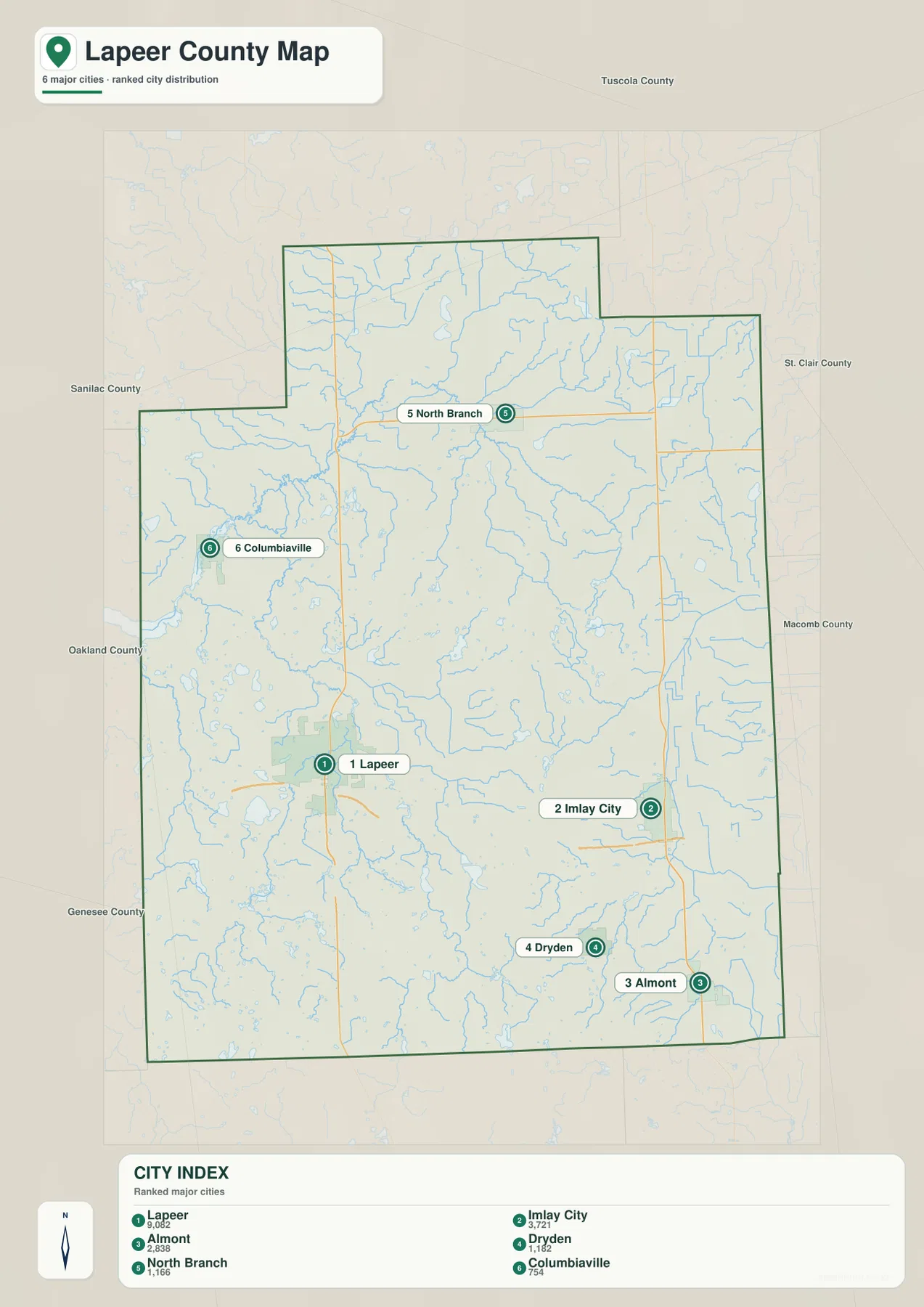
The city index should not be read as a complete directory of every settlement. The general map also labels places such as Clifford, Attica, and Metamora, and additional unincorporated communities may not appear in the ranked layer at all. For that reason, the city sheet works best as a quick comparison tool rather than a substitute for a municipal directory or current population table. When the exact route to a place matters, return to the general map because it carries the major highway context that the simplified city sheet intentionally reduces.
Neighboring county labels provide another useful clue to location. Tuscola County appears to the north, St. Clair and Macomb counties are shown along the eastern side, and Genesee and Oakland counties appear to the west or southwest, with Sanilac also labeled on the western side of the map. Those labels make it easier to see how close Imlay City and Almont are to the eastern edge and how far Columbiaville sits toward the west. The city sheet therefore works as both a settlement overview and a quick regional locator.
The Flint and Belle river systems give the county two distinct water settings
The terrain and water map changes the visual emphasis completely. In the northwest and central interior, the Flint River system is the most prominent feature. North Branch Flint River comes down from the north through a broad web of smaller streams. South Branch Flint River is labeled near the Barnes Lake area, and the Flint River name appears farther west. Instead of one simple channel, the map shows a branching network that gathers many tributaries across the upper and western portions of the county.
The southeast is organized around different names. North Branch Belle River and Belle River cross the side of the county associated with Imlay City and Almont, creating a second clearly identifiable river system. This is easy to overlook on a road-focused map, where highways dominate the page, but it becomes obvious once the water layer is isolated. A practical reading method is to separate the two systems before studying smaller streams: establish the Flint River side in the northwest and central area, then find the Belle River side in the southeast.
Lakes provide smaller landmarks between the larger river systems. Barnes Lake lies near the northwestern drainage network; Pleasant Lake and Bronson Lake are labeled in the west; Elk Lake and Long Lake appear closer to the central interior; Lake Pleasant is farther east; and Nepessing Lake and Lake Lapeer stand out in the southwest. These water names are useful because they give the reader fixed points in parts of the county where the road map may show fewer major intersections.
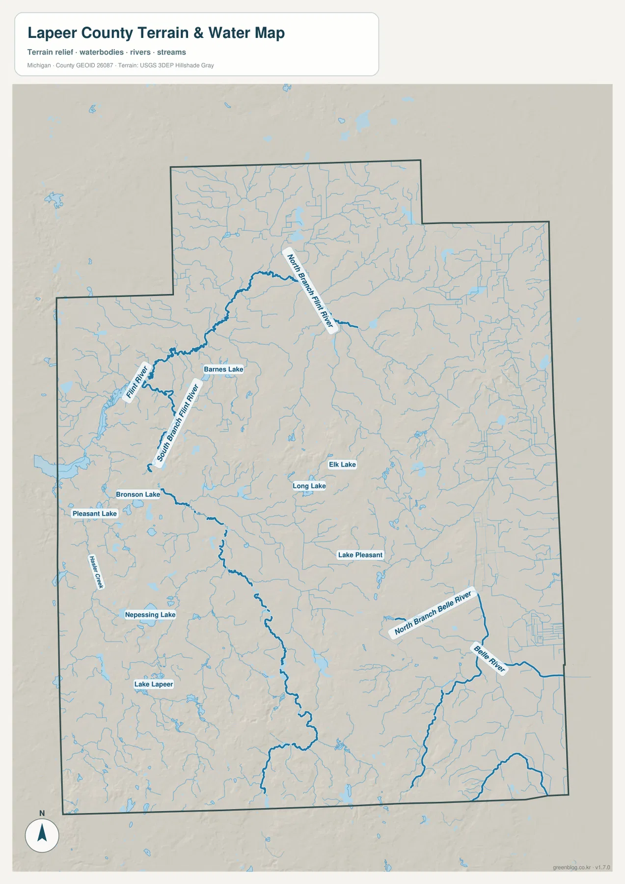
This sheet is a general hydrographic reference, not a flood map, navigation chart, depth map, or parcel-boundary product. It can show that Nepessing Lake lies in the southwestern part of the county or that North Branch Flint River approaches from the north, but it does not establish flood elevations, boating restrictions, shoreline ownership, or water depth. Readers who need those details should use the relevant official product. For ordinary geographic orientation, however, starting with the named rivers and lakes keeps the dense tributary pattern manageable.
Southern hills stand above lower northern and eastern ground
The elevation map shows that Lapeer County is not a uniformly flat landscape. The legend gives an actual range of roughly 229 to 386 meters and a mean near 264 meters. Much of the north and east is rendered in green, indicating relatively lower ground, while yellows and browns become more common toward the south. The strongest high-elevation colors cluster along the southern and southwestern edge, where a series of hills stands out clearly from the surrounding lower terrain.
The pattern is not a perfect north-to-south staircase. Smaller ridges and isolated higher patches appear through the middle and eastern interior, and portions of the north also rise above nearby low ground. Even so, the broad contrast remains easy to see: southern Lapeer County contains the most prominent uplands, while lower corridors extend through much of the north and along portions of the east. Some of those lower corridors broadly coincide with valleys visible on the water map, which helps explain why the river and elevation sheets complement each other.
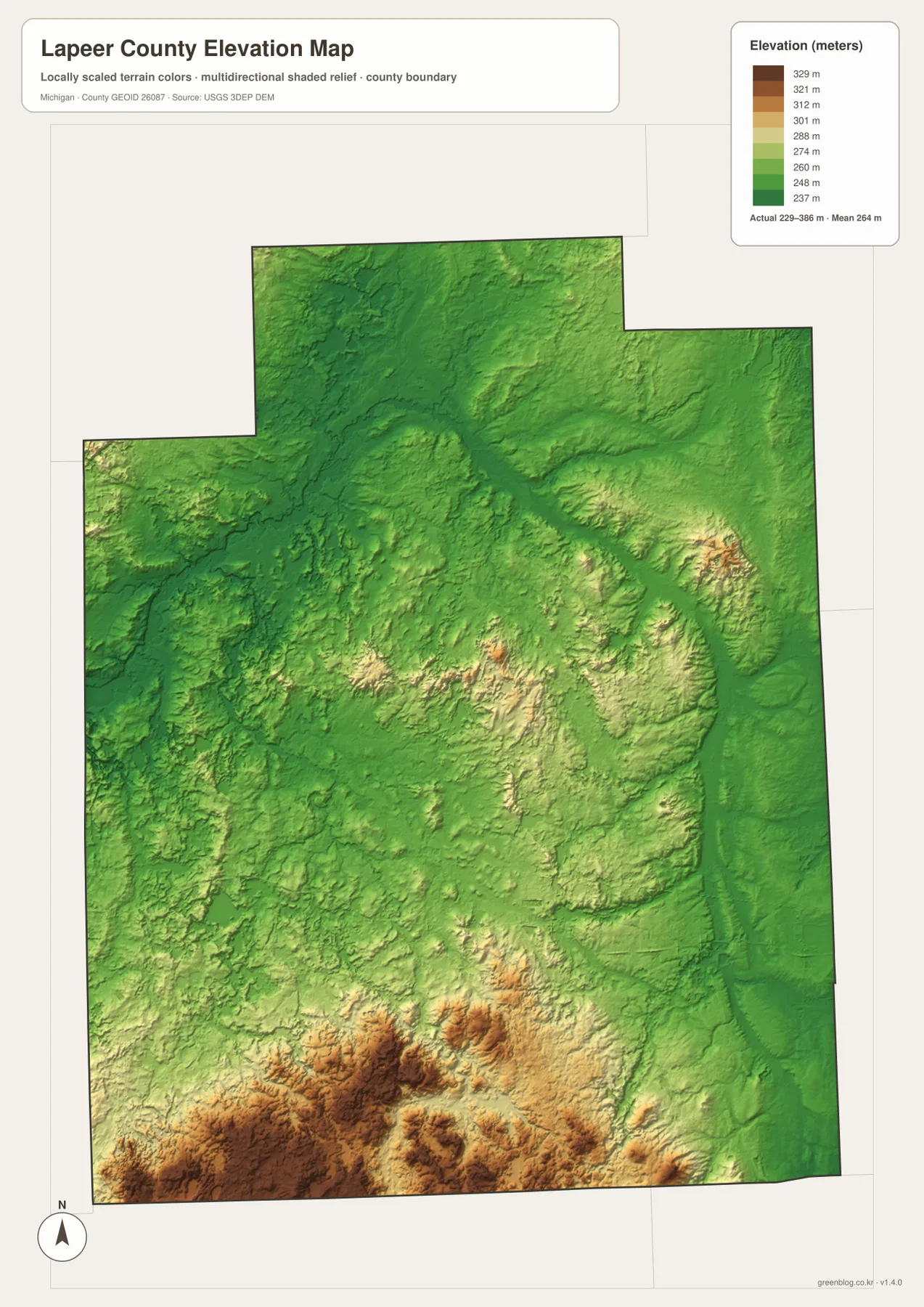
The shaded surface is intended for county-scale comparison rather than survey work. It is useful for understanding why the southern part of the county appears hillier and why some stream corridors occupy lower ground, but an individual property elevation cannot be read accurately from this image. Engineering design, grading, drainage calculations, and legal elevation work require official source data and, where appropriate, field surveying. For classroom, regional, or general travel context, the color contrast is much easier to interpret than a long table of elevation values.
Places such as Metamora and Dryden are near parts of the southern area where warmer elevation colors are more frequent, while the North Branch side is surrounded by more extensive green terrain. The eastern boundary also contains long lower-looking corridors that contrast with the brown and tan uplands in the southwest. The map should not be used to predict the exact grade of a road, but it does give a convincing visual explanation for the county’s broad topographic differences.
Choose the map that answers the first question, then add detail
A reader who is new to the area can avoid information overload by using the maps in a simple order. First, locate Lapeer and Imlay City and note the directions of M-24, I-69, M-53, and M-90. Next, use the city sheet to place North Branch, Almont, Dryden, and Columbiaville around those anchors. Then open the water map and separate the Flint and Belle river systems before tracing smaller tributaries. Finally, compare the elevation sheet to see how the southern uplands differ from the lower northern and eastern areas.
The same method can be adapted to a specific part of the county. For the Lapeer-to-Imlay City corridor, begin with I-69 and compare the M-24 and M-53 junctions. On the water map, look toward the Belle River names as the focus moves east. On the elevation map, compare that eastern side with the stronger uplands farther south and southwest. For North Branch or Columbiaville, the more useful references are M-90, M-24, the Flint River branches, Barnes Lake, and the western cluster of lakes.
For printing or detailed viewing, the downloadable ZIP contains four high-resolution JPG maps matching the county, city, water, and elevation sheets. These files are better suited to a large display, classroom handout, regional presentation, or printed reference than the smaller WebP previews embedded in the article. They remain general reference maps, however. Legal boundary decisions, parcel surveying, flood regulation, navigation, and engineering work should always rely on the official source designed for that purpose.
Frequently Asked Questions
What is the easiest map for comparing Lapeer and Imlay City?
Use the city distribution map for the quickest comparison of their relative positions, then return to the general county map for road context. Lapeer sits where M-24 meets I-69, while Imlay City lies farther east near the I-69 and M-53 junction. The shared interstate and different north-south highways make the two communities useful anchors for the southern half of the county.
How can I separate the Flint River and Belle River systems on the water map?
Start with the large named channels rather than the smallest tributaries. North Branch Flint River, South Branch Flint River, and Flint River organize the northwestern and central side of the sheet. North Branch Belle River and Belle River identify the southeastern side near the Imlay City-Almont area. Once those names are established, the smaller streams and nearby lakes are much easier to place.
Can the 229–386 meter elevation range be used as a property elevation?
No. The elevation sheet is a generalized county-scale surface for comparing broad high and low areas. It is useful for seeing the stronger southern and southwestern uplands and lower terrain elsewhere, but site design, grading, drainage calculations, and exact property elevations require official elevation data and site-specific surveying.
Sources and Reference Information
- Lapeer County, Michigan official website: county government and local information.
- Lapeer County Hazard Mitigation Plan: local history and information about rivers, lakes, and natural resources.
- U.S. Census Bureau TIGER/Line Shapefiles: county boundary and road reference data.
- USGS National Hydrography: river, lake, and stream reference data.
- USGS 3D Elevation Program: elevation reference data.
Map File Information
Lapeer County Map Files
- Included Files: County, city, water, and elevation map JPGs
- File Type: High-resolution JPG files in one ZIP archive
Related Maps
Green Map creates custom-edited map images using open geographic data sources such as geoBoundaries, Natural Earth, OpenStreetMap, and government open data. These maps are edited visual materials, not raw data files, and are provided for education, documents, presentations, and graphic reference.