McPherson County lies in central Kansas with the city of McPherson serving as the strongest reference point on the supplied maps. Lindsborg is well to the north, Moundridge to the southeast, Inman to the southwest, and Galva and Canton to the east. US 56 crosses the county through McPherson, while I-135 and US 81 are prominent in the southeastern half. This spread of towns and highways makes the county easy to read when the map is approached as several connected corridors rather than one compact settlement area. High-resolution map files are available for download in the section below.
This page separates roads and communities from water and elevation so each layer remains readable. The online WebP images are lightweight previews, while the original high-resolution JPG versions of all four supplied maps can be downloaded together in one ZIP for printing, classroom use, and offline reference. The set is particularly useful for comparing the Little Arkansas River and Turkey Creek lowlands with higher western uplands and for locating McPherson State Fishing Lake near the Canton area.
Table of Contents
McPherson anchors the US 56 corridor and the county’s main road junctions
The general county map places McPherson near the center of the road network. US 56 approaches from the west, crosses the city, and continues east toward Galva and Canton. A major north–south route descends through the southeastern part of the county toward Moundridge, with I-135 and US 81 shields visible on the map. K-153 is also marked near McPherson, giving the central city several different highway references.
Lindsborg lies to the north near K-4, which extends west toward the Marquette direction. Inman is in the southwest near K-61, while Galva and Canton align more closely with the east–west US 56 corridor. Elyria appears south of McPherson and Roxbury is a smaller northeastern community. Together these labels show that McPherson County’s towns are distributed around a central hub but remain separated by broad rural areas.
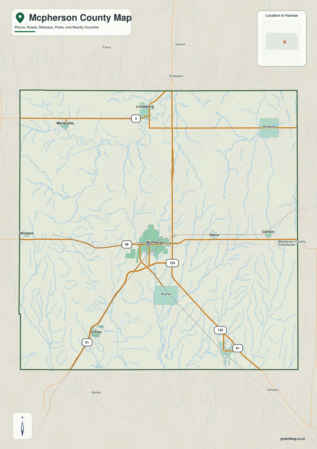
McPherson is slightly south of the county’s midline, so it works well as a reference when comparing Lindsborg to the north with Moundridge to the southeast. Inman sits on a different southwestern route, while Galva and Canton create a clear eastward sequence. The map does not replace turn-by-turn navigation, but it gives a reliable first look at which towns share the same general direction from the central city.
The six-city index separates McPherson from smaller centers around the county
The simplified city map highlights six major communities and prints a ranked city index. McPherson appears first at 13,995, followed by Lindsborg at 3,792, Moundridge at 1,628, Inman at 1,325, Galva at 1,002, and Canton at 706. These values are the index numbers displayed on the supplied map and should not be treated as a substitute for the latest official population estimate. They are most useful for understanding the relative emphasis of the six mapped centers.
The arrangement is as important as the ranking. Lindsborg occupies the northern side, Moundridge the southeast, and Inman the southwest. Galva and Canton sit east of McPherson along a similar latitude, while McPherson itself remains the strongest central reference. This layout makes it easy to divide the county mentally into northern, eastern, southwestern, and southeastern town groups before moving to a more detailed road view.
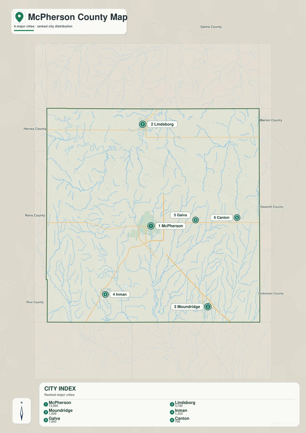
Neighboring county labels add regional context. Saline County is shown to the north, Marion County to the east, Harvey County to the west, and Reno and Rice counties toward the western and southwestern sides. Those labels are geographic orientation rather than route instructions, but they help place McPherson County within central Kansas before a reader focuses on individual towns.
Little Arkansas River, Turkey Creek, and eastern streams divide the water map into distinct areas
The Little Arkansas River is one of the strongest water features in the southwest, where it follows the county edge and nearby low ground. Turkey Creek forms another long channel through the south-central interior, running through a broad valley below McPherson and west of the Moundridge side of the county. These waterways are especially useful when compared with the elevation layer because their valleys appear lower than many surrounding ridges.
In the northeast, Gypsum Creek is labeled near McPherson County State Lake. The North Cottonwood River follows the eastern edge, while Sharp Creek is visible in the northwest. Several smaller named water bodies are also printed on the map, including Gas Lake, Clear Pond, Countryside Lake, Cedars Lake, Lakeside Lake, and Lake Inman. The result is a water map that shows both major drainage lines and local ponds or lakes.
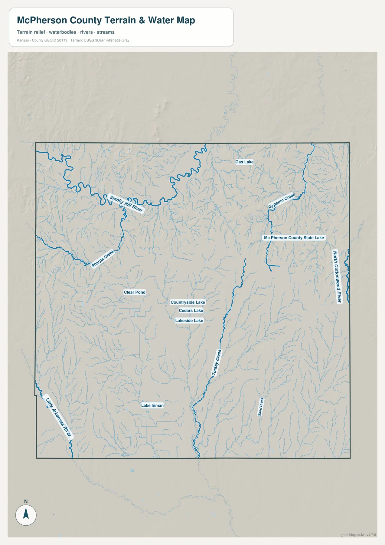
McPherson State Fishing Lake is associated with the Maxwell Wildlife Refuge area north of Canton. Visit McPherson describes the refuge as a prairie site north of Canton and notes the fishing lake along its western side. Kansas Wildlife & Parks information also treats the lake and refuge together, making this northeastern section of the county a useful example of how the water map connects local recreation features with surrounding terrain.
This map is for geographic water reference, not floodplain, navigation, water-quality, access, or parcel decisions. A stream line does not guarantee a particular flow or depth at the time of a visit, and a mapped lake does not by itself indicate current boating or camping rules. Use current agency information whenever safety, access, or recreation regulations matter.
Elevation from about 388 to 518 meters contrasts western uplands with lower northern ground
The elevation map gives an actual county range of about 388 to 518 meters, with a mean near 454 meters. The strongest brown tones occur along parts of the west and northwest, where ridges rise above the center of the county. Broad green areas occupy much of the north and north-central interior, indicating lower ground. Additional low zones appear in the south and southwest where stream valleys cut across the county.
Around McPherson, the surface changes gradually rather than forming one abrupt escarpment. Eastward toward Galva and Canton, moderate uplands are broken by narrow drainage lines. Along the western side, the higher colors become more prominent, while around Lindsborg the northern landscape contains wider green lowlands cut by smaller creeks. These contrasts explain why the shaded relief looks more rugged near some county edges than across the central interior.
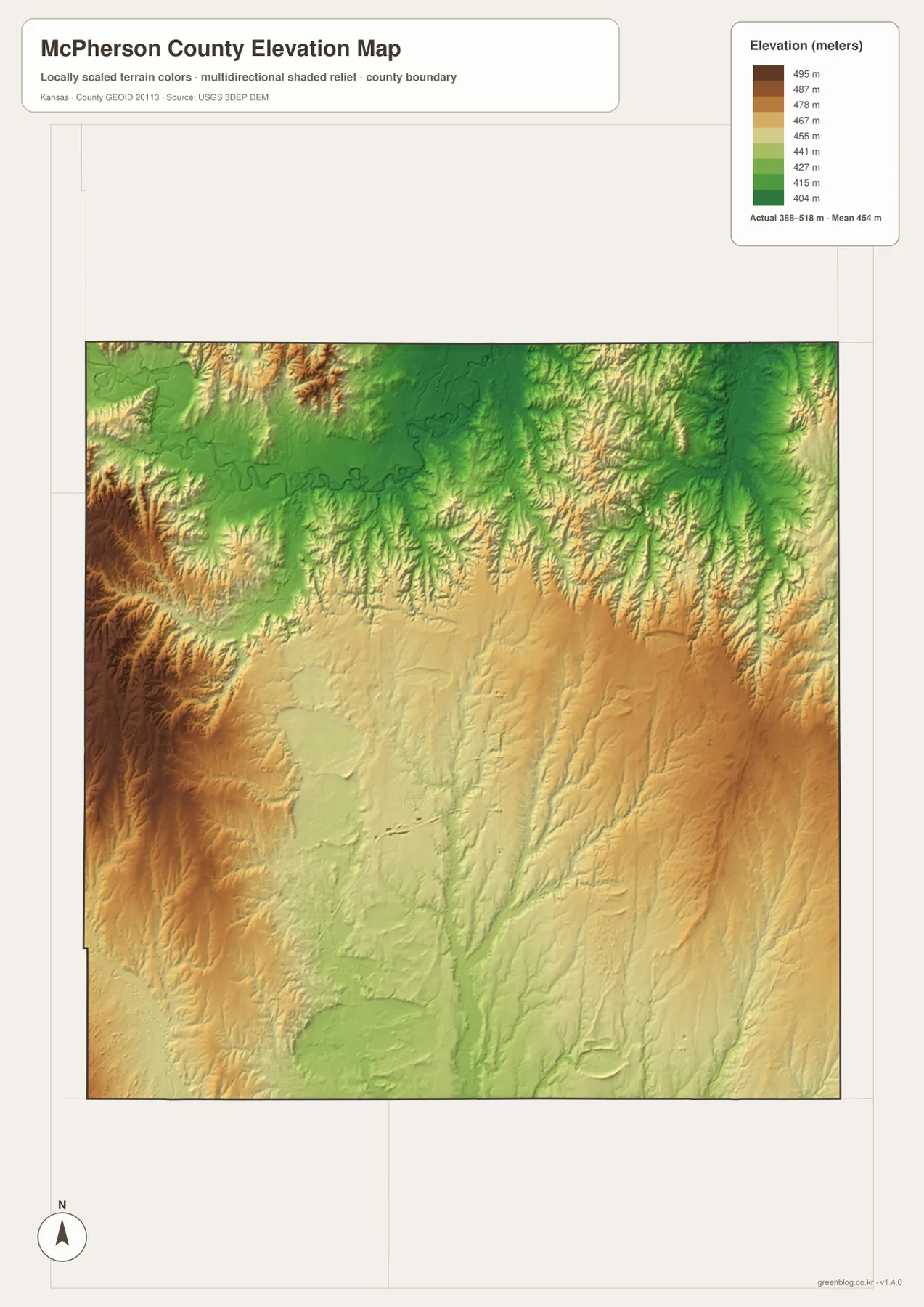
Waterways line up closely with many of the low areas. Turkey Creek follows a south-central depression, the Little Arkansas River occupies a southwestern low corridor, and the North Cottonwood River remains lower than nearby eastern ridges. Gypsum Creek also follows a lower path toward the McPherson State Fishing Lake area. Reading the elevation and water maps together makes these relationships clearer than either layer alone.
The elevation surface is generalized for county-scale comparison. It should not be used to establish a parcel elevation, construction grade, drainage design, or legal boundary. Precise site work requires appropriate detailed elevation data and, when necessary, professional field surveying. For classroom, travel, and regional reference, the map is best used to compare broad uplands and stream valleys.
North of Canton, lake and prairie references converge near Maxwell Wildlife Refuge
Canton provides a convenient town reference for the northeastern recreation area. On the city map it lies east of McPherson, while the water map places McPherson State Fishing Lake farther north near Gypsum Creek. Visit McPherson describes Maxwell Wildlife Refuge as being north of Canton and notes that the state fishing lake sits along the refuge’s western side. That relationship makes the Canton area easy to identify when switching between the city and water maps.
Kansas Wildlife & Parks material describes McPherson State Fishing Lake as a 46-acre surface-water lake with primitive camping and fishing facilities beside the Maxwell Wildlife Refuge. Those details are useful background, but the supplied county map is not a campground or facility plan. Before traveling, check current rules, closures, and access information directly from the managing agency.
Lindsborg and McPherson provide a simple north-to-center frame for the county
Lindsborg is the strongest northern city in the six-city index, while McPherson occupies the central portion of the county. On the general map, Lindsborg sits near K-4 and McPherson lies on US 56 with additional north–south connections. Numerous small creeks occupy the space between them, and the elevation map shows that much of the northern interior is lower than the pronounced western uplands.
South of McPherson, the road network continues toward Elyria and the Moundridge direction. Inman remains separate to the southwest, while Galva and Canton extend the town pattern eastward from McPherson. Thinking of Lindsborg–McPherson–Moundridge as a rough north-to-south sequence, then adding Inman to the southwest and Galva–Canton to the east, provides a simple mental map of the county’s major communities.
Choose the map layer that matches the question
The general county map is the best starting point when roads, towns, surrounding counties, and overall orientation matter at the same time. It shows how US 56 relates to McPherson, Galva, and Canton and how I-135–US 81 approaches the southeastern section. The city map is cleaner when the goal is simply to compare the six ranked communities without route clutter.
Use the terrain-and-water map for the Little Arkansas River, Turkey Creek, Gypsum Creek, North Cottonwood River, and local lakes. Switch to the elevation layer when you want to compare the western uplands with lower stream corridors. For example, locating Inman first and then moving through the water and elevation maps makes the nearby Little Arkansas River lowland easier to understand.
For large-format printing or presentation slides, use the original JPG files in the download archive instead of enlarging the web previews. The high-resolution versions preserve smaller road labels, creek names, city text, and the elevation legend more clearly. If a map is cropped for a handout, keep enough surrounding context—such as a north arrow, road number, or legend—to make the selected area understandable.
Frequently Asked Questions
Which map is best for comparing McPherson and Lindsborg?
The city map is the simplest way to compare their relative positions because McPherson is near the center and Lindsborg is clearly to the north. Use the general county map next if you also need US 56, K-4, and the surrounding road network.
Where is McPherson State Fishing Lake on the county map set?
It appears on the terrain-and-water map in northeastern McPherson County, north of the Canton area and near Gypsum Creek. It is associated with the Maxwell Wildlife Refuge area, so current recreation and access details should be checked with Kansas Wildlife & Parks before a visit.
Can the 388–518 meter elevation map be used for property surveying?
No. It is a generalized county-scale surface intended to compare uplands and valleys. Parcel elevations, construction grades, drainage design, and legal boundary work require more precise official data and, where appropriate, professional surveying.
Map File Information
The archive contains the McPherson County, Kansas general county map, city map, terrain-and-water map, and elevation map as original high-resolution JPG files for printing and offline use.
- Included Files: Use only the versions confirmed in the article and supplied images
- File Type: Use the confirmed download contents
- Intended Use: Printing, education, presentations, and map-based projects
Related Maps
Sources and references
- McPherson County official website — county government and local information
- Visit McPherson: Maxwell Wildlife Refuge — refuge and McPherson State Fishing Lake location and visitor context
- Kansas Wildlife & Parks: Maxwell Wildlife Refuge & McPherson State Fishing Lake — lake and refuge facilities
- U.S. Census Bureau TIGER/Line Shapefiles — county boundary and geographic reference data
- USGS National Hydrography — river and stream reference data
- USGS 3D Elevation Program — elevation and terrain reference data
Green Map creates custom-edited map images using open geographic data sources such as geoBoundaries, Natural Earth, OpenStreetMap, and government open data.
These maps are edited visual materials, not raw data files, and are provided for education, documents, presentations, and graphic reference.