Acadia Parish lies in southwestern Louisiana, where Crowley serves as the parish seat and a broad road network links Rayne, Church Point, Iota, Morse, Mermentau, and smaller rural communities. This Acadia Parish Map collection follows I-10, US 190, LA 13, LA 35, and other routes while also showing the bayous, canals, and drainage features that cross the parish’s low-relief landscape.
The map files can be downloaded as high-resolution JPGs after the web previews. Louisiana’s official parish profile identifies Crowley as the parish seat and lists the municipalities that spread across Acadia Parish. Rather than treating the area as a simple road grid, the three supplied maps make it possible to compare the main towns with Bayou Plaquemine Brule, Bayou Wikoff, Bayou Mallet, drainage canals, and the wide rural spaces between them.
Table of Contents
I-10 ties Crowley and Rayne together while parish roads spread toward Iota and Church Point
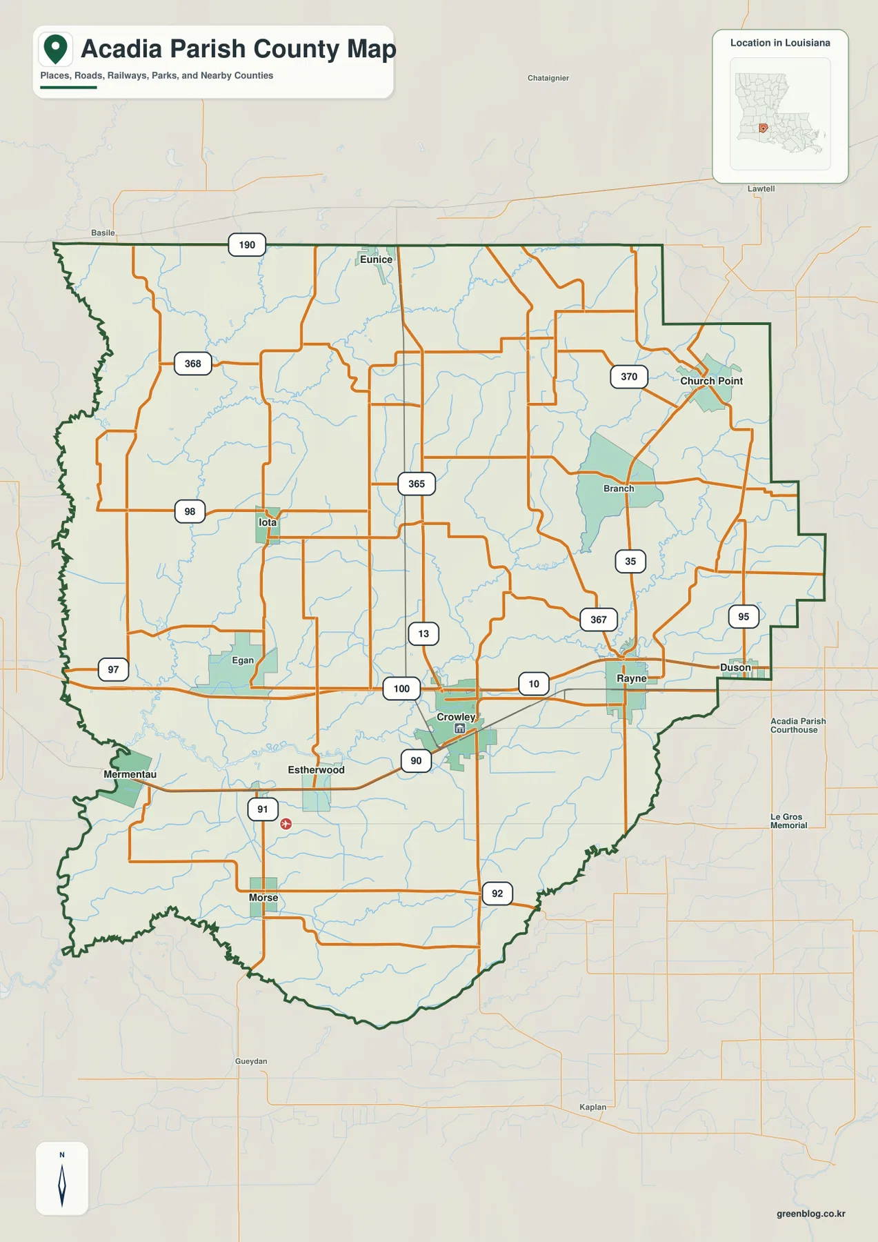
Crowley is the easiest point from which to read the general map. I-10 passes just north of the city and continues east toward Rayne, creating the clearest east-west travel corridor in the parish. LA 13 runs through the Crowley area and provides a strong north-south reference. Local roads spread west toward Egan and Iota, south toward Estherwood and Morse, and east toward Rayne, making Crowley the most useful road anchor even though several other towns have their own local networks.
Rayne sits east of Crowley close to I-10 and the LA 35 corridor. Farther northeast, Church Point is another distinct center near LA 35 and LA 370. Duson appears near the eastern edge toward Lafayette Parish, while Eunice and US 190 lie close to the northern boundary. These places show how the parish connects outward in several directions instead of relying on one single highway.
The western side has a different spacing. Iota is clearly marked along the LA 98 area, Mermentau sits near the southwestern edge, and Morse lies farther south. Egan, Estherwood, Branch, and other smaller labels fill the rural space between the major communities. Roads are often relatively direct compared with mountain counties, but they still adjust around bayous, canals, and drainage lines that cross the prairie landscape.
This general map is designed for geographic orientation rather than live navigation. It does not show current traffic, temporary closures, flood-related road restrictions, or private access. A current navigation service is appropriate for driving decisions; this file is better for understanding the relative position of Crowley, Rayne, Church Point, Iota, I-10, US 190, and the parish boundary.
The eastern half is organized by Bayou Plaquemine Brule, Bayou Wikoff, and a web of drainage lines
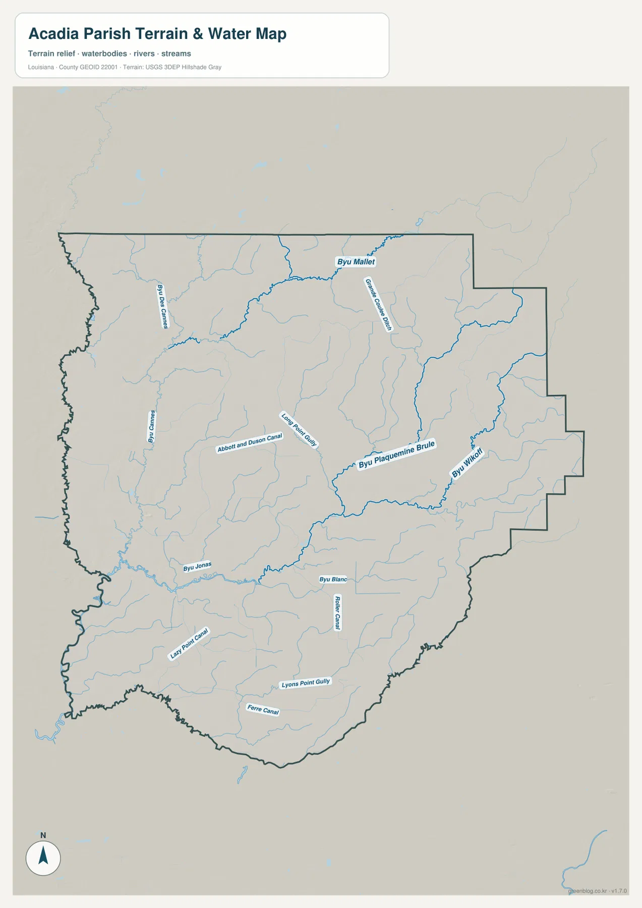
The water map has no single dominant lake or mountain river. Instead, long bayous and engineered channels cross the parish in several directions. Bayou Plaquemine Brule is the strongest feature through the east-central area, and Bayou Wikoff follows another prominent course farther east. Numerous smaller tributaries enter both waterways, producing a dense drainage pattern around the Rayne and Church Point side of the parish.
North of the central area, Bayou Mallet stretches across the upper part of the map. Bayou des Cannes is labeled in the northwest, while Grande Coulee Ditch drops southward nearby. Abbott and Duson Canal and Long Point Gully add another set of named channels through the central-western interior. The mix of bayou, ditch, canal, and gully names is important because it shows both natural drainage and human-managed water routes on the same map.
The southern half contains Bayou Jonas and Bayou Blanc, with Roller Canal running nearby. Lazy Point Canal appears in the southwest, while Lyons Point Gully and Ferre Canal are labeled farther south. These channels pass through broad rural areas between Crowley, Morse, Mermentau, and the southern parish boundary. When compared with the road map, they explain why seemingly open farmland still contains many water crossings and drainage corridors.
The terrain-and-water file should not be used as a flood-insurance map, water-depth chart, legal boundary record, or drainage-rights document. Water levels and flood conditions change, and the map does not establish ownership or regulatory status. Current parish, Louisiana, FEMA, or USGS information is required for those decisions.
Six major city markers show a parish spread from Church Point to Mermentau
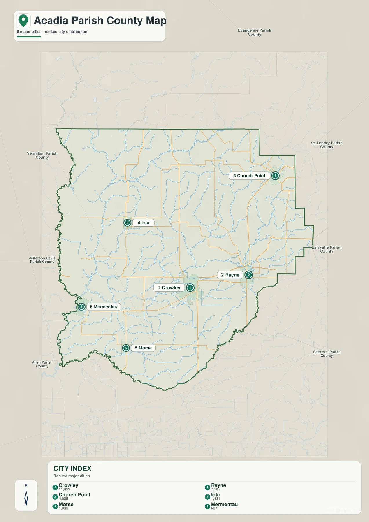
The city-distribution map reduces the road detail and highlights six major references. Crowley sits near the center-south and is ranked first in the source snapshot, Rayne is east, Church Point is northeast, and Iota is west. Morse and Mermentau anchor the southern and southwestern parts of the parish. The arrangement gives Acadia Parish a useful set of reference points in almost every direction from Crowley.
The surrounding parish labels add regional context. Evangeline Parish is north, St. Landry Parish is northeast, Lafayette Parish is east, Cameron Parish is southeast, Allen Parish is southwest, Jefferson Davis Parish is west, and Vermilion Parish lies toward the northwest side shown on the map. The exact boundary is irregular in places, but the city map makes Acadia Parish’s position within southwestern Louisiana easier to place.
The numbers printed in the city index belong to the dataset snapshot used to build the map and should not be treated as current official population totals. The Louisiana parish profile and U.S. Census Bureau are better sources for current administrative and demographic information. Here, the city map is most useful for comparing where Crowley, Rayne, Church Point, Iota, Morse, and Mermentau sit relative to one another.
A trip outward from Crowley reveals four different parts of the parish
East from Crowley toward Rayne, I-10 provides the strongest road reference. Bayou Plaquemine Brule and Bayou Wikoff become increasingly important on the water map, and the settlement pattern grows denser toward Rayne and the Lafayette Parish side. This eastern corridor is the clearest place to see major transportation routes and large named bayous close together.
North and northeast toward Church Point, LA 35 and LA 370 help organize the road view. Bayou Mallet, Grande Coulee Ditch, and a network of smaller channels occupy the same general part of the parish. Church Point is well separated from Crowley on the city map, so the northeastern quarter reads as its own local center rather than simply an extension of the I-10 corridor.
West toward Iota and southwest toward Mermentau, towns are farther apart and the rural road network opens up. Bayou des Cannes and Bayou Jonas provide strong water references across that side. South toward Morse, Roller Canal, Lazy Point Canal, Lyons Point Gully, and Ferre Canal become more noticeable. Comparing these directions shows how roads and waterways divide the parish into recognizable local areas even though the overall terrain remains low and gently varying.
Choose the Acadia Parish file by the question you are trying to answer
The general map is the best starting point for Crowley, Rayne, Church Point, road numbers, and the parish outline. The city map is cleaner when the relative positions of the six major communities matter most. The terrain-and-water map is the strongest choice for Bayou Plaquemine Brule, Bayou Wikoff, Bayou Mallet, canals, and smaller drainage features. Only these three map types are supplied in this package; there is no separate elevation map.
- General map: Use it for Crowley, Rayne, Church Point, Iota, Mermentau, Morse, I-10, US 190, LA 13, LA 35, LA 98, LA 365, and other roads.
- City map: Use it to compare Crowley, Rayne, Church Point, Iota, Morse, and Mermentau without the full road detail.
- Terrain and water map: Use it for Bayou Plaquemine Brule, Bayou Wikoff, Bayou Mallet, Bayou des Cannes, Bayou Jonas, Bayou Blanc, and the named canals and gullies.
Each original JPG measures 2572 × 3638 pixels in portrait orientation, preserving more small road and water labels than the web previews. Keeping the original aspect ratio is recommended for printing. When using all three files together, begin with Crowley and the main roads, then compare the city distribution and drainage network so the same locations remain easy to follow.
Frequently Asked Questions
Which map is best for Crowley, Rayne, and I-10?
The general map is the best choice because it combines Crowley and Rayne with I-10, US 190, LA 13, LA 35, LA 98, LA 365, Church Point, Iota, Mermentau, Morse, and the parish boundary.
Where can I see Bayou Plaquemine Brule and Bayou Wikoff?
The terrain-and-water map shows both bayous along with Bayou Mallet, Bayou des Cannes, Bayou Jonas, Bayou Blanc, Grande Coulee Ditch, Abbott and Duson Canal, and several other channels. It is a geographic reference rather than a flood, depth, or legal-boundary map.
Are the city-index population numbers current?
They should be treated as source-snapshot values, not as current official counts. Use the U.S. Census Bureau for recent population data and use this map primarily to compare the locations of Crowley, Rayne, Church Point, Iota, Morse, and Mermentau.
Map File Information
The ZIP contains high-resolution JPG versions of the Acadia Parish general map, city map, and terrain-and-water map. Use the previews to check Crowley, Rayne, Church Point, major roads, Bayou Plaquemine Brule, Bayou Wikoff, and the canal network before opening the original files.
- Included Files: Use only the versions confirmed in the article and supplied images
- File Type: Use the confirmed download contents
- Intended Use: Printing, education, presentations, and map-based projects
Related Maps
Sources and references
The geographic discussion is based primarily on the supplied Acadia Parish maps, with official parish, city, state, boundary, and hydrography sources used for context.
- Acadia Parish Police Jury — official parish government, departments, and local administration.
- Louisiana.gov Acadia Parish Profile — parish seat and official municipality information.
- City of Crowley official website — official city government and services.
- U.S. Census Bureau TIGER/Line Shapefiles — official geographic boundary and road data.
- USGS National Hydrography — federal hydrography background for bayous, streams, and water features.
Green Map creates custom-edited map images using open geographic data sources such as geoBoundaries, Natural Earth, OpenStreetMap, and government open data. These maps are edited visual materials, not raw data files, and are provided for education, documents, presentations, and graphic reference.