Gove County lies in northwestern Kansas, where the settlement pattern is easiest to understand by combining the I-70 corridor with the county seat at Gove City. Quinter is the largest city shown on the city map, while Grainfield, Grinnell, and Park also cluster near the northern east-west route. Gove City sits farther south along K-23 and serves as the county seat. High-resolution JPG versions of the maps shown on this page can be downloaded together from the ZIP box below. High-resolution map files are available for download in the section below.
The county is crossed by several long drainage systems rather than one dominant river through the center. Big Creek and its north fork drain the northern uplands, the Hackberry Creek system cuts across the middle, and Plum Creek and Indian Creek cross the southern half. The Smoky Hill River follows the southern edge. Elevation ranges from about 690 to 932 meters with a mean near 817 meters, creating a strong west-to-east decline across the county.
The Kansas Historical Society places Gove County in both the High Plains and Smoky Hills physiographic regions. The official county website lists Quinter, Gove City, Grainfield, Grinnell, and Park among its communities and also highlights Castle Rock and Monument Rocks as notable natural sights. The article below focuses on the places, roads, streams, and relief visible in the supplied maps while using those official sources for broader county context.
Table of Contents
The I-70 and U.S. 40 corridor across northern Gove County
The general map gives northern Gove County a clear transportation spine. I-70 and U.S. 40 run east and west across the top of the county, connecting Quinter, Grainfield, and Grinnell. Park lies close to the same corridor, and K-211 provides a short local connection in the north-central area. Oakley appears beyond the western side and Collyer beyond the east, helping place the county within the wider northwestern Kansas highway network.
Gove City sits well south of that northern corridor and is reached most easily by following K-23 through the center of the county. K-23 provides the strongest north-south reference on the map and continues toward the southern boundary. This creates a useful two-axis framework: the northern cities line up with the interstate corridor, while the county seat occupies a separate central position along the vertical state route.
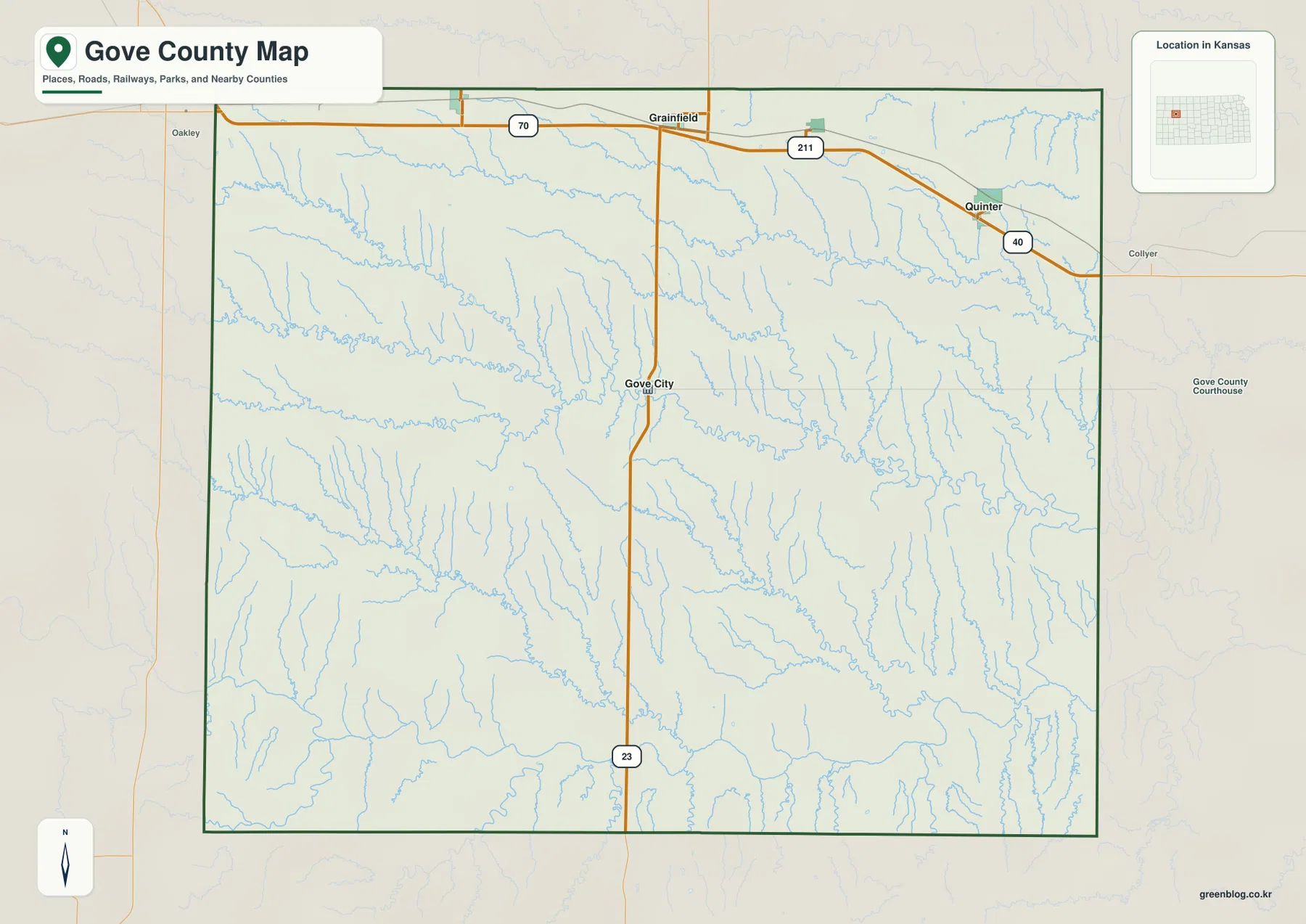
Away from the northern highway corridor, settlement labels become sparse and the map is dominated by rural roads and drainage lines. The eastern and southeastern sections are especially cut by tributary valleys. This map is designed for county-scale orientation rather than live navigation, so current road work, winter conditions, high-wind advisories, and closures should be checked separately.
Quinter, Grinnell, Grainfield, Park, and the county seat at Gove City
The city distribution map ranks Quinter first, Grinnell second, Grainfield third, Park fourth, and Gove City fifth. The ranking reflects the population data used for the map, but the more important geographic pattern is the concentration of the larger communities near the northern transportation corridor. Gove City is smaller in population yet remains essential because it is the county seat.
Quinter anchors the northeast, Grinnell the northwest, and Grainfield occupies the north-central part of the county. Park is close to Grainfield, while Gove City stands alone near the middle. Rather than imagining one continuous chain of towns, it is more accurate to see a northern settlement belt paired with a separate administrative center along K-23.
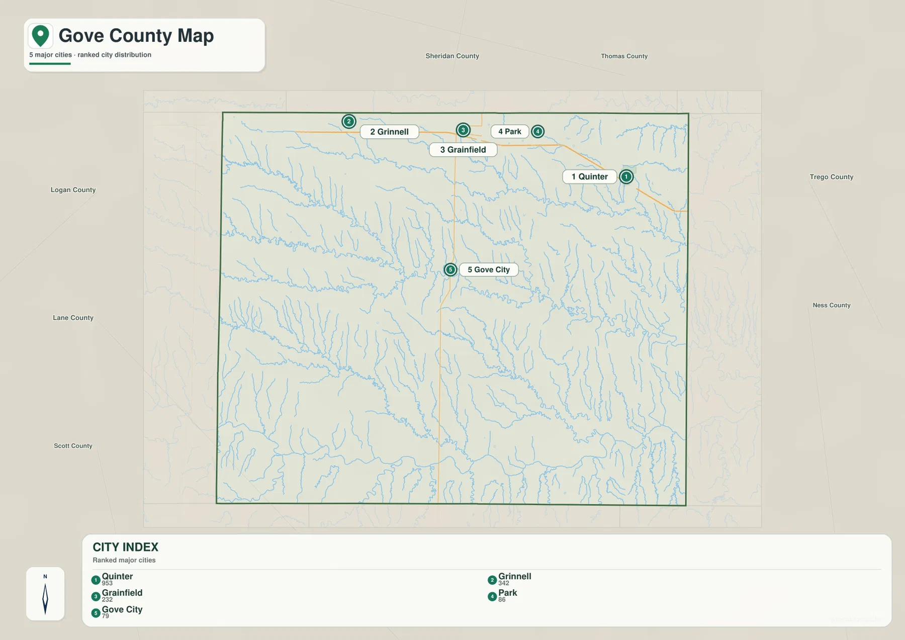
The Kansas Historical Society identifies Gove as the county seat, and the current Gove County government website lists the same principal communities. This makes the difference between population rank and administrative importance especially clear. For orientation, Quinter works well for the interstate corridor, while Gove City is the better reference for the county government and central road network.
Big Creek and the Hackberry Creek network
Big Creek is one of the most prominent northern waterways on the terrain map. North Fork Big Creek joins the system from the north, while East Spring Creek occupies a lower central-northern valley. The main channel continues eastward through increasingly dissected terrain, showing how a broad High Plains surface can be divided by repeated stream valleys.
The central county is dominated by Hackberry Creek and its branches. North Branch, Middle Branch, and South Branch Hackberry Creek descend from the western uplands and feed the main channel. Their valleys become more obvious toward the center and east, where shaded relief reveals many narrow tributaries cutting into the surface. This drainage network gives the area around Gove City far more local relief than a simple road map suggests.
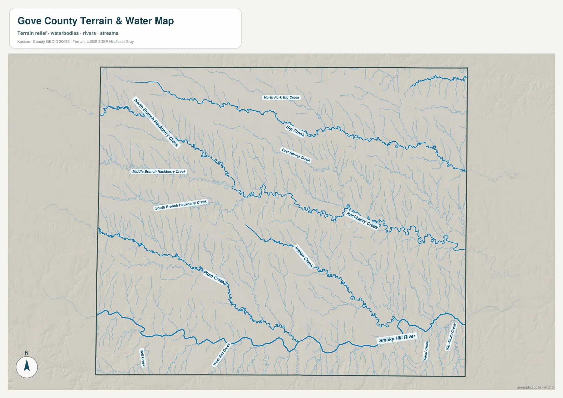
South of the Hackberry system, Indian Creek and Plum Creek form long drainage routes across the southern half. The Smoky Hill River follows the southern edge, accompanied by smaller tributaries such as Wolf Salt Creek, Hill Creek, and Sand Creek. The map is a geographic reference rather than a live source for streamflow, flood warnings, or water quality.
The Smoky Hill River along the southern county
The Smoky Hill River creates the largest continuous river corridor along the southern side of Gove County. Its broad valley contrasts with the narrower tributary networks farther north. Indian Creek and Plum Creek occupy adjacent southern drainage areas, tying the interior uplands to the same lower regional landscape.
The Kansas Historical Society notes that the Smoky Hill Trail passed through Gove County. Although the historic trail should not be treated as identical to modern roads, it adds context to the role of the southern plains and river country as a travel corridor. Today the main long-distance highway lies much farther north along I-70, providing an interesting contrast between older and modern movement routes.
Current river conditions can vary considerably, especially along smaller tributaries after storms. Anyone needing flood, streamflow, or road-crossing information should use current USGS and local sources rather than the static map. The purpose here is to show how the southern river valley fits with the county’s broader High Plains drainage.
A 690–932 meter decline from western uplands to eastern valleys
The elevation map shows an actual range of approximately 690 to 932 meters and a mean elevation near 817 meters. Brown and dark orange colors dominate the west and northwest, marking the highest broad surfaces. Moving east, colors shift through tan and yellow-green into large areas of green, indicating a clear overall drop in elevation.
The major streams follow that gradient. Big Creek and Hackberry Creek occupy lower bands through the uplands, and their tributaries create increasingly dense green valleys toward the east. The Smoky Hill River also occupies a broad low corridor in the south. The southwest retains significant high ground, so the county is not a perfectly even slope, but the west-to-east pattern is still unmistakable.
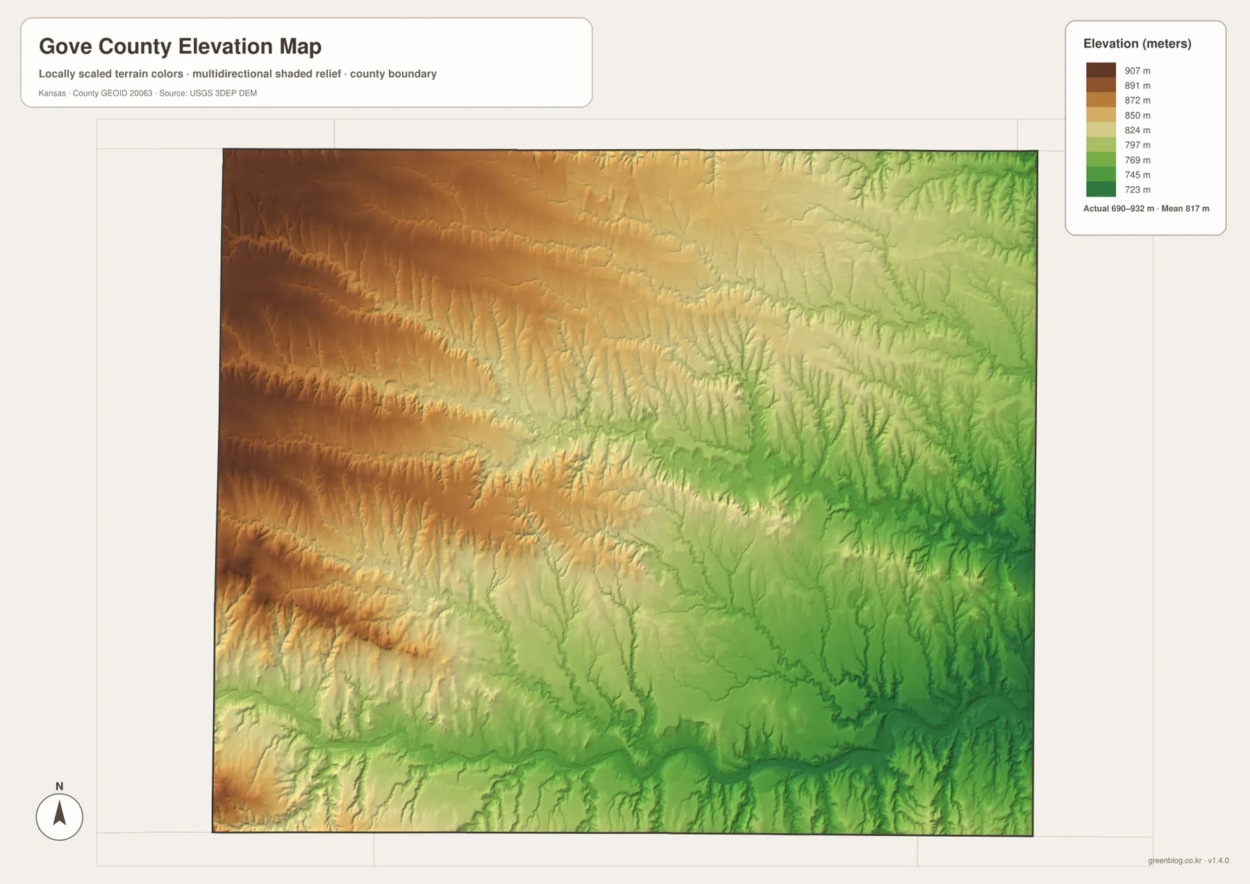
This elevation surface is intended for county-scale comparison rather than survey-grade measurement. It should not be used to establish exact parcel elevations, design drainage, or replace engineering and legal survey data. Its value is visual context: the map makes it easy to see how western uplands feed the Big Creek, Hackberry Creek, and Smoky Hill River valleys.
High Plains, Smoky Hills, and the county’s natural landmarks
The Kansas Historical Society describes Gove County as spanning the High Plains and Smoky Hills. The distinction is visible in the map set as a transition from broad higher surfaces in the west to more strongly dissected terrain toward the east and southeast. The boundary between those landscapes is gradual rather than a sharp line, because streams progressively cut deeper into the plain.
The official Gove County website highlights Castle Rock in the eastern part of the county and Monument Rocks in the southwest as notable natural sights. Those landmarks are not labeled directly on the supplied county maps, so they should be located with dedicated visitor information before travel. Their presence nevertheless reinforces the idea that Gove County includes dramatic erosional landforms as well as broad agricultural plains.
Gove County was established in 1868 and organized in 1886. Its settlement pattern today reflects both transportation and administrative geography: the northern cities align with the I-70 corridor, while Gove City remains the county seat farther south. Streams, uplands, and long rural road distances fill most of the space between those communities.
Using the maps for study, printing, and orientation
For general orientation, start with Quinter, Grainfield, and Grinnell along I-70/U.S. 40, then follow K-23 south to Gove City. For physical geography, compare Big Creek in the north, Hackberry Creek across the center, and Plum Creek, Indian Creek, and the Smoky Hill River in the south. The elevation map then explains why those drainage systems deepen toward the lower eastern side.
The high-resolution JPG files in the ZIP are better suited than reduced web previews for printing, classroom work, regional reports, and close inspection of labels. They are useful for county overviews and geographic comparison, but current roads, live stream conditions, parcel boundaries, and exact elevations should always be checked against the latest authoritative sources when those details matter.
Frequently Asked Questions
Which community is the county seat, Gove City or Quinter?
Gove City is the county seat. Quinter is the largest city shown on the city distribution map, but Gove City holds the administrative role and sits farther south along K-23. Using both places as references provides a better understanding of the county than relying on population rank alone.
What are the main drainage systems in Gove County?
Big Creek is prominent in the north, Hackberry Creek and its branches cross the central county, and Plum Creek and Indian Creek occupy the south. The Smoky Hill River forms the largest continuous river corridor along the southern edge.
Can the 690–932 meter elevation map be used for surveying?
No. The elevation map is a county-scale visual reference for comparing uplands and valleys. Exact parcel elevations, construction design, drainage engineering, and legal surveys require purpose-built data and professional methods appropriate to those tasks.
Map File Information
Download the high-resolution JPG files corresponding to the Gove County general, city distribution, terrain-and-water, and elevation maps in one ZIP archive.
- Included Files: Use only the versions confirmed in the article and supplied images
- File Type: Use the confirmed download contents
- Intended Use: Printing, education, presentations, and map-based projects
Related Maps
Sources and references
- Gove County, Kansas official website — county communities, natural sights, and government information
- Kansas Historical Society — Gove County, Kansas — county seat, High Plains, Smoky Hills, and county history
- U.S. Census Bureau TIGER/Line — boundary, road, and geographic data resources
- USGS National Hydrography — hydrography and stream-network data information
- USGS 3D Elevation Program — elevation data information
Green Map creates custom-edited map images using open geographic data sources such as geoBoundaries, Natural Earth, OpenStreetMap, and government open data. These maps are edited visual materials, not raw data files, and are provided for education, documents, presentations, and graphic reference.