Download the high-resolution Starke County JPG maps in one ZIP from the file box below. The archive contains the general county, city-connections, terrain-and-water, and elevation views at 3638×2572 pixels each. On the page, the maps show Knox near the center, North Judson to the southwest, Hamlet to the north, Bass Lake in the southeast, and a landscape that changes from low Kankakee and Yellow River country in the west to higher, more broken ground along the eastern side.
This Starke County Map set is easiest to use by keeping Knox fixed as the main reference point. Route 35 provides a clear north–south line through the Knox area, while Route 10 crosses the southern half from North Judson toward Bass Lake. Grovertown sits farther northeast, San Pierre is near the southwestern side, and the county’s irregular northern boundary becomes easier to understand once Hamlet and the nearby road network are located.
The physical maps show a modest but clear east–west relief difference. The elevation legend gives an actual county range of about 201 to 237 meters and a mean of 214 meters. Broad green low ground covers much of the west and north-central interior, while tan and brown terrain becomes more common toward the eastern edge and southeast. Yellow River and several ditches cut lower corridors through that surface.
Table of Contents
Knox and North Judson make Route 35 and Route 10 the easiest road references
Knox is the clearest starting point on the general county map. Route 35 runs north–south through the Knox side, and Route 10 crosses the southern half toward Bass Lake. Routes 8 and 100 appear east of Knox, while Route 400 is labeled farther south. Using Route 35 as the vertical reference and Route 10 as the southern east–west reference makes the smaller roads much easier to place.
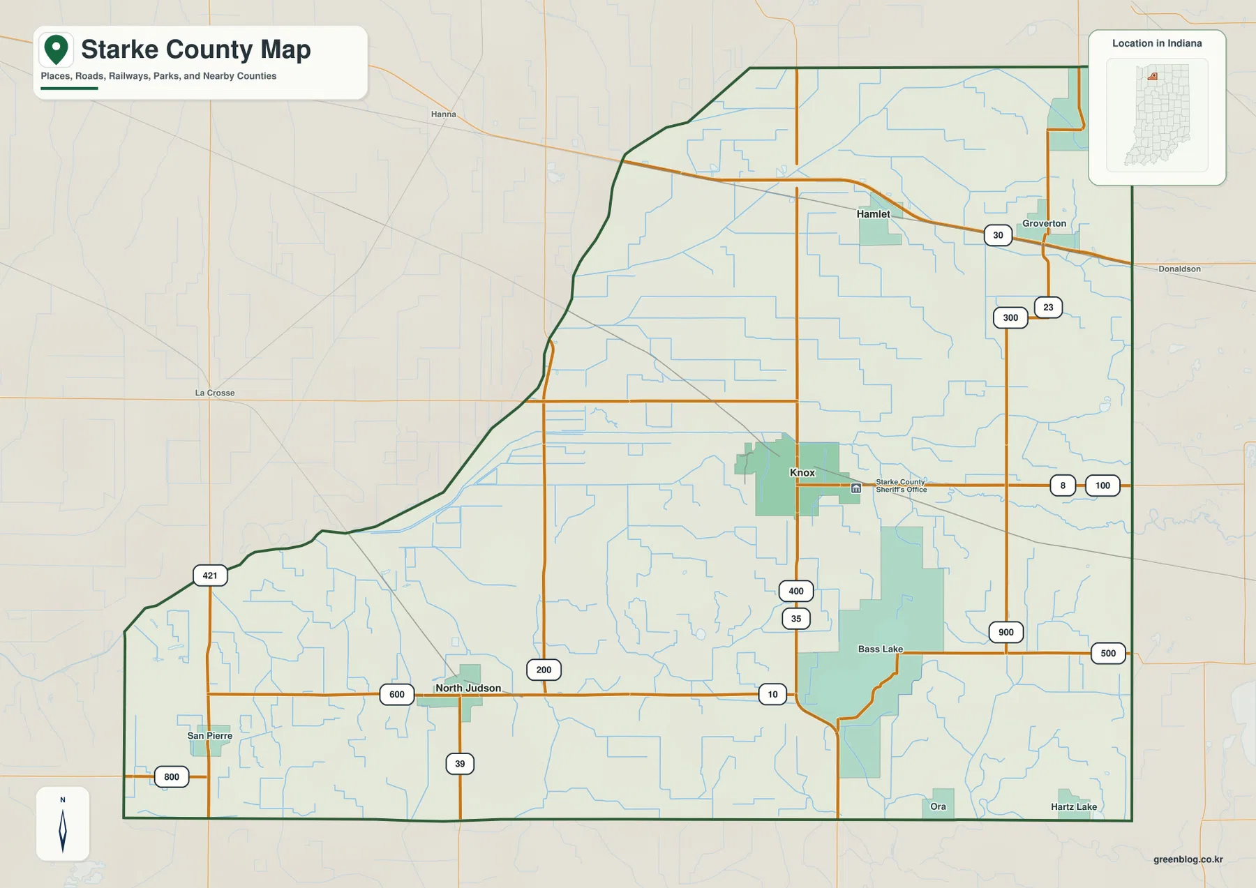
North Judson lies southwest of Knox near the Route 10 and Route 39 area. Route 600 appears farther west, and San Pierre is close to the southwestern boundary near Routes 421 and 800. This side of the county has fewer large place labels and more small waterways, so the numbered routes are especially useful as orientation lines.
Hamlet and Grovertown help organize the north. Hamlet is north of Knox, while Grovertown sits farther northeast near Routes 30 and 23. Route 300 is also labeled in the northeastern area. The northern county line changes shape toward the northwest instead of forming a simple rectangle, and those place references make the boundary easier to follow.
Bass Lake becomes the main southeastern reference. Route 10 passes north of the lake, and Routes 900 and 500 appear nearby. Ora and Hartz Lake sit closer to the southern boundary. The general map is useful for relative position, place names, and route direction, but current construction, closures, and travel restrictions should be checked with a current transportation source.
North Judson and Hamlet show two very different directions from Knox
The city-connections map reduces the county to Knox, North Judson, and Hamlet. North Judson is shown about 10 miles southwest of Knox, while Hamlet is about 6 miles north. The map identifies these as direct distances, so they are straight-line measurements rather than driving mileage. Actual road trips can be longer depending on the route.
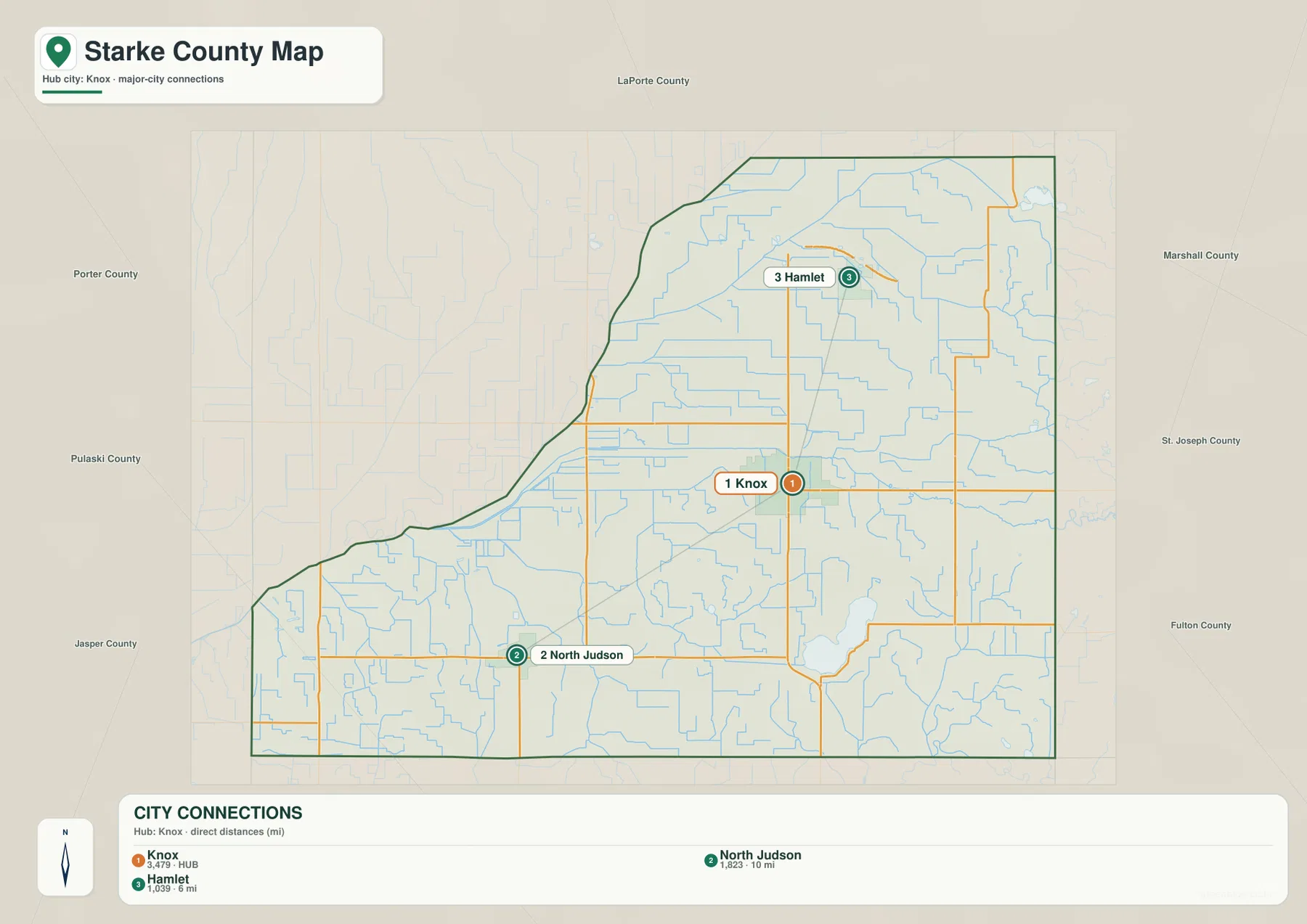
The two directions also point toward different county settings. North Judson is associated with the lower southwestern side and the Route 10–39 road area. Hamlet lies in the north-central interior, which remains broadly low on the elevation map and contains several long drainage channels. Their locations therefore help organize both the road and physical maps.
Numeric values are printed with the three place names, but the supplied package does not identify their statistical year or provide a separate source. This article therefore does not present them as current official population. A current U.S. Census product should be used when up-to-date population is needed; here, the city map is used for location, direction, and stated direct distance.
Neighboring county labels include Porter, LaPorte, Marshall, St. Joseph, Fulton, Pulaski, and Jasper counties. North Judson lies closer to the southwestern side, while Hamlet is farther north in the interior. Reading those labels around the boundary gives a quick sense of Starke County’s position before returning to the detailed road map.
Yellow River, Bass Lake, and straight drainage ditches shape the county’s water map
Yellow River is the strongest central water feature on the terrain-and-water map. It stretches across the county in a broad east–west course, while Kankakee River is labeled near the western side. Eagle Creek appears farther east near Eagle Lake. Finding those larger named waters first makes the many smaller ditches and lakes much easier to place.
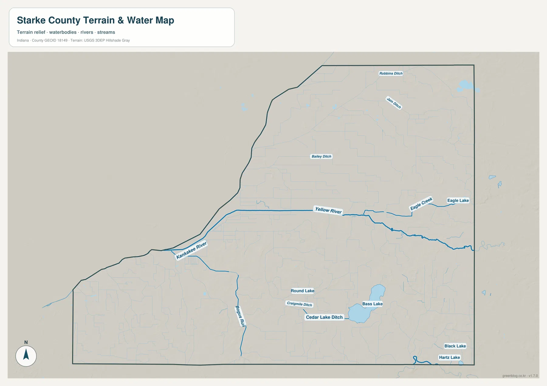
Bass Lake is the largest clearly labeled southeastern lake, with Round Lake to the northwest. Cedar Lake Ditch and Craigmile Ditch cross the same broad low area, while Black Lake and Hartz Lake appear farther south and east. These water bodies are close to one another but are shown separately rather than as one connected lake system.
The northern half contains several long, relatively straight channels, including Robbins Ditch, Jain Ditch, and Bailey Ditch. Their geometry is easy to distinguish from the more naturally curving Yellow River. Bogus Run is labeled farther southwest. The combination of rivers, creeks, ditches, and lakes is one of the defining features of the supplied water map.
This map is a county-scale water reference rather than a flood map, parcel map, legal water-boundary product, depth chart, drainage-engineering plan, or navigation guide. It is appropriate for locating named rivers, creeks, ditches, and lakes and comparing them with roads and the county boundary. Current flood conditions or site-specific water decisions require dedicated agency data.
The 201–237 meter surface rises from broad western low ground toward the east
The elevation legend reports an actual Starke County range of about 201 to 237 meters and a mean of 214 meters. Green represents lower terrain within the county-scale display, shifting through lighter green and tan to brown at higher elevations. Much of the west and north-central interior is low and green, while the eastern edge and southeast contain noticeably more tan and brown terrain.
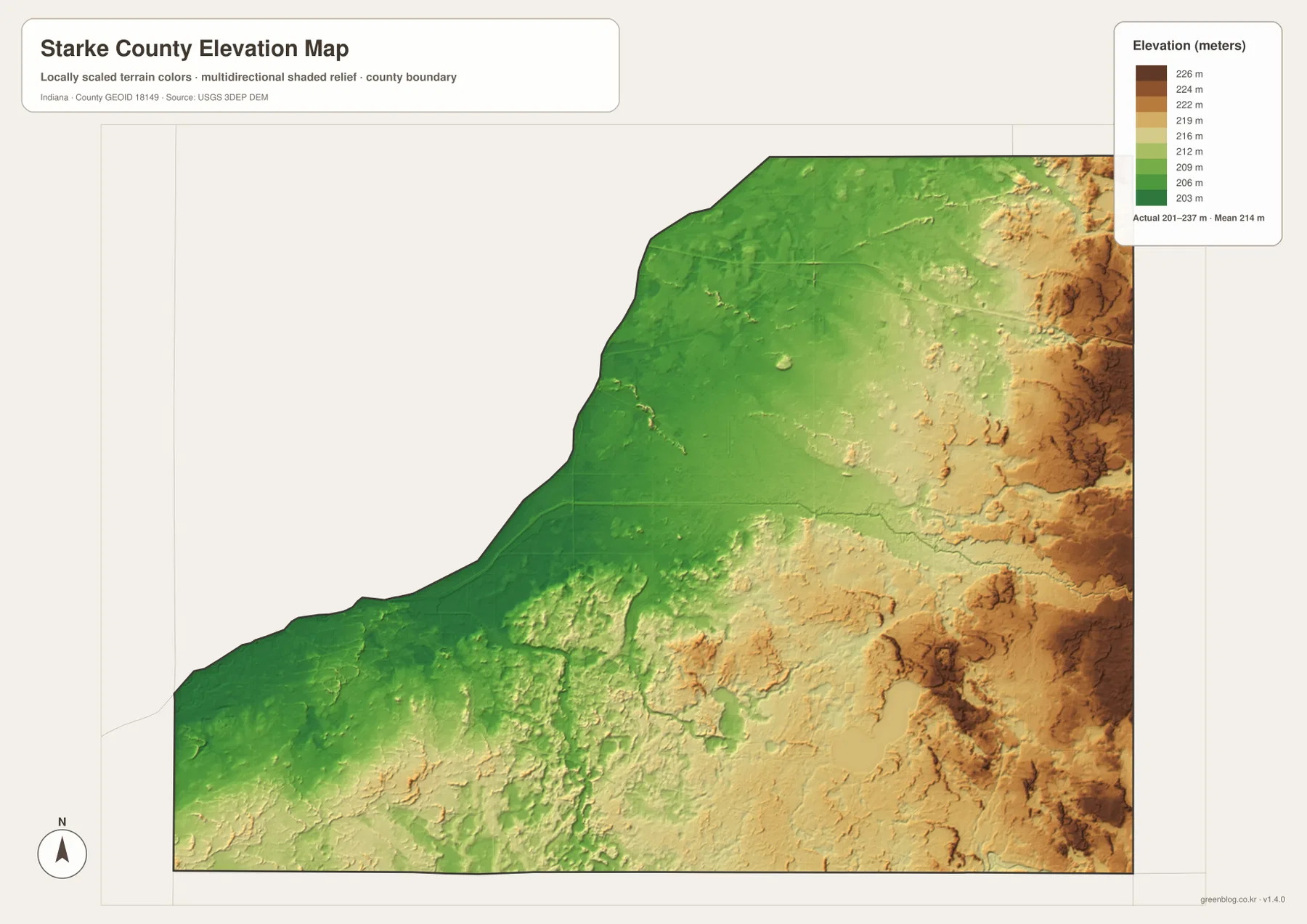
The eastern high ground is not one continuous flat surface. Narrow green and light-green corridors cut through the tan and brown areas, and small ridges repeat along the edge. Comparing Eagle Creek and other eastern channels on the water map with the elevation image makes those lower corridors easier to recognize.
The west is lower overall but still contains subtle relief. Yellow River and Kankakee River occupy low corridors, while ditches and small ridges break up the broad green surface. The county is therefore better described as wide western low ground rising toward a more broken eastern side than as a perfectly smooth incline.
The elevation map is designed for county-level comparison rather than survey-grade measurement. It should not be used to assign an exact elevation to a house, road point, field, or construction site. The range and mean are useful regional reference values, but precise site elevations require source data or professional survey measurements.
Keep Knox fixed while moving from roads to water and relief
For ordinary orientation, begin with the general county map and locate Knox, North Judson, Route 35, and Route 10. The city-connections map is cleaner when the goal is simply to compare North Judson and Hamlet from Knox by direction and straight-line distance. Returning to the road view after that makes Grovertown, Bass Lake, and San Pierre easier to place.
For water features, use the terrain-and-water map to locate Yellow River, Kankakee River, Bass Lake, and the named ditches. Then find the same areas on the elevation map. The western river country remains broadly low, while the eastern side rises into more broken high ground.
The WebP previews are optimized for browser viewing. The downloadable ZIP contains the original high-resolution JPG versions of the general county map, city-connections map, terrain-and-water map, and elevation map. Each file is a landscape image measuring 3638 by 2572 pixels, making the originals better for enlarging small route, ditch, and creek labels or preparing an A3 print.
A practical comparison routine is to keep Knox fixed as the reference point. Find Route 35 and Route 10 on the general map, place North Judson and Hamlet on the city view, then follow Yellow River and locate Bass Lake on the water map. Finish with the elevation image and compare the lower western greens with the higher eastern tans and browns.
Frequently Asked Questions
Are the 10 miles to North Judson and 6 miles to Hamlet driving distances?
No. The city-connections map identifies them as direct distances. North Judson is about 10 straight-line miles southwest of Knox, while Hamlet is about 6 straight-line miles north. Actual road mileage can be longer depending on the route used.
Which water features sit around the Bass Lake side of the county?
Bass Lake is the largest clearly labeled southeastern lake, with Round Lake to the northwest. Cedar Lake Ditch and Craigmile Ditch cross the same broad low area, while Black Lake and Hartz Lake appear farther south and east. They are shown as separate water bodies rather than one connected lake.
Where does the elevation map show the clearest countywide contrast?
The clearest contrast is between broad green low ground across the west and north-central interior and higher tan-brown terrain along the east and southeast. The legend reports an actual range of about 201–237 meters and a mean of 214 meters.
Map File Information
Download the high-resolution JPG originals for the Starke County general map, city-connections map, terrain-and-water map, and elevation map in one ZIP. Use the originals when small road, ditch, or creek labels need to remain clear or when preparing an A3 print.
- Printable Size: 3638×2572 px each
Related Maps
Sources and References
The road, settlement, water, and elevation descriptions above are based on the supplied Starke County maps and asset information. The official resources below are useful when source boundary, hydrography, or elevation data is needed.
- U.S. Census Bureau TIGER/Line Shapefiles – official county boundary, road, and place reference data
- USGS National Hydrography – official river, creek, ditch, and lake data information
- USGS 3D Elevation Program – elevation source data and program information
Green Map creates custom-edited map images using open geographic data sources such as geoBoundaries, Natural Earth, OpenStreetMap, and government open data.
These maps are edited visual materials, not raw data files, and are provided for education, documents, presentations, and graphic reference.