Kootenai County in northern Idaho brings together one of the state’s most concentrated urban areas, a large lake basin, and rugged mountain country within the same county boundary. The general county map places Coeur d’Alene and Post Falls along the western side, shows I-90 crossing from the Washington line toward the mountains, and follows US 95 north through the populated corridor toward Hayden and Athol. Farther south and east, Lake Coeur d’Alene and steep, stream-cut ridges become the dominant features. This page explains those patterns from the supplied maps, and the same four map themes are available as high-resolution JPG files in a downloadable ZIP.
The contrast is easy to see before reading any labels in detail. City names and major roads cluster around Coeur d’Alene, Post Falls, Hayden, Rathdrum, and nearby communities, while much of the eastern half is filled with drainage lines and mountain relief rather than large settlements. Lake Coeur d’Alene extends south from the urban area and breaks the county into very different travel and terrain settings. That combination makes the county easier to understand when roads, cities, water, and elevation are viewed separately rather than forced into one crowded map.
The WebP images in the article are sized for quick viewing on a web page. The download archive contains 3638×2572-pixel JPG versions of the county map, ranked-city map, terrain-and-water map, and elevation map. Those larger files are more useful when you need to zoom in on road numbers, small place names, creeks, or shoreline details, or when you want an image suitable for printing or a presentation.
Table of Contents
The Coeur d’Alene–Post Falls corridor and the roads that organize western Kootenai County
On the general county map, the western edge provides the clearest starting point. I-90 enters near State Line, passes through Post Falls, and continues through Coeur d’Alene before turning toward the mountains to the east. US 95 crosses that route at Coeur d’Alene and runs north through the Hayden area toward Athol. Together, those two highways form an easy reference for locating most of the county’s better-known communities and for understanding why so many labels are concentrated in the western and northwestern part of the map.
North of Post Falls, ID 41 continues through Rathdrum toward Spirit Lake, while ID 53 crosses the Hauser–Rathdrum area. Around Athol, US 95 and ID 54 provide another clear set of road references. The map becomes much less road-dense as it extends east from this populated corridor. In the mountainous half of the county, fewer major highways are labeled and the network of streams and ridges becomes more visually prominent than city blocks or large developed areas.
Lake Coeur d’Alene changes the road pattern again south of the main urban area. Fernan Lake Village sits close to Coeur d’Alene on the east side, while Harrison appears near the southeastern side of the lake. Roads along the lake and through the adjoining mountains bend with the shoreline and terrain rather than following the straighter grid seen around Post Falls and Rathdrum. ID 97 and ID 3 are among the labeled routes in the southern and southeastern part of the county, where the map clearly shifts from an urban-road view to a lake-and-mountain setting.
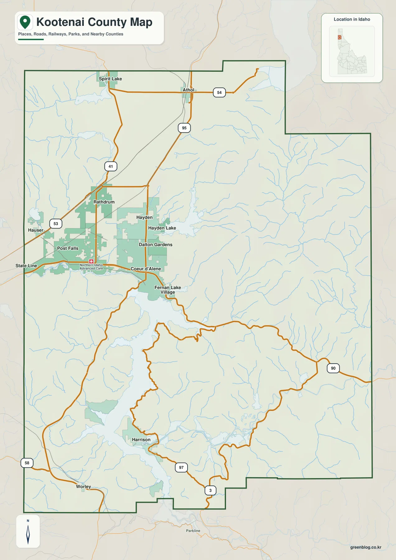
This general map is designed for county-scale orientation rather than parcel or legal-boundary decisions. It helps answer practical questions such as where Post Falls sits relative to Coeur d’Alene, which highway continues north toward Hayden and Athol, and how the lake separates routes in the south. For property research, official boundary work, or current road administration, the county’s own mapping tools and current Census boundary products should be used alongside this overview.
Six ranked cities reveal how strongly settlement is concentrated in the west
The city map strips away much of the road detail and ranks six major cities. Coeur d’Alene is shown first, followed by Post Falls, Hayden, Rathdrum, Dalton Gardens, and Spirit Lake. All six fall in the western or northwestern portion of the county rather than being evenly distributed across the entire area. That pattern is one of the clearest takeaways from the map: the populated corridor occupies a relatively small part of a county that extends much farther into mountain country to the east and south.
Coeur d’Alene sits near the northern end of Lake Coeur d’Alene, with Post Falls to the west toward the Washington border. Hayden and Dalton Gardens are close to Coeur d’Alene on the north side, Rathdrum lies farther northwest, and Spirit Lake is more isolated to the north. When this simplified view is compared with the general road map, the relationship between the cities and I-90, US 95, and ID 41 becomes easy to follow without the distraction of every smaller place name.
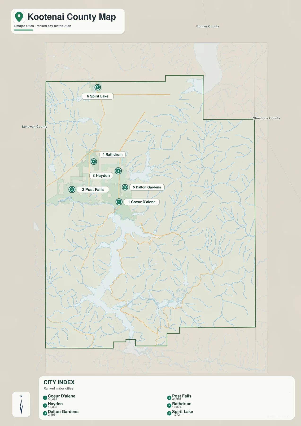
The population figures printed in the map index are best treated as the snapshot used to build this graphic, not as a substitute for a current population estimate. The useful geographic message is the rank and location of the cities. Anyone who needs the latest counts or growth figures can check Census QuickFacts separately, where the date and statistical vintage are stated explicitly.
Lake Coeur d’Alene connects the Spokane River with a mountain network of eastern streams
The terrain-and-water map is dominated by Lake Coeur d’Alene. The Spokane River leaves the lake at the northwest side and runs west toward Post Falls and Washington, while the Coeur d’Alene River approaches from the east through the mountain valleys. This makes the lake more than a large blue feature in the center of the county: it is the meeting point between major river systems, the urban lowland to the northwest, and rugged drainage basins to the east.
In the eastern mountains, the North Fork Coeur d’Alene River runs through a long valley and is joined by numerous smaller tributaries. The map also labels Wolf Lodge Creek, Rose Creek, and LaTour Creek, among others. Their positions help explain why the eastern half looks so different from the relatively open western corridor. Short ridges and narrow valleys repeat across the shaded relief, and blue stream lines follow those valleys toward the larger river and lake system.
Around the lake, labels such as Mica Bay, Rockford Bay, Windy Bay, and Cougar Bay make it easier to identify different sections of the shoreline. Those names are useful orientation points, especially because the lake has a long, irregular shape with many inlets and projecting ridges. The map should not be read as a boating chart, flood map, or depth map, however. It shows the relative position of water and terrain; it does not provide channel depth, navigation hazards, real-time lake level, or flood probability.
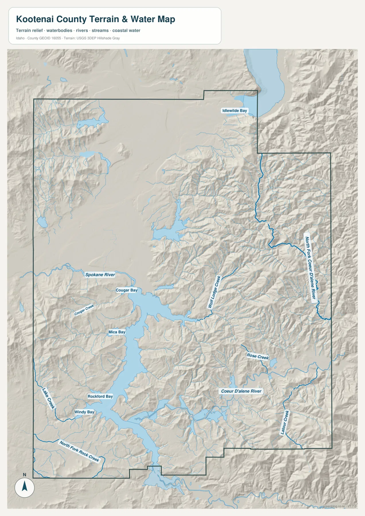
For detailed hydrography, USGS National Hydrography is a better source than a presentation map. Here, the value comes from seeing the county-scale relationship: a large lake occupies the central-southern basin, the Spokane River exits west, and the Coeur d’Alene River and its tributaries gather water from the mountainous east. Once that framework is clear, smaller creek and bay names are much easier to place.
Elevation rises from the 618 m lowlands to 1,936 m mountain ridges
The elevation map reinforces the same west-to-east contrast seen in the other maps. Its summary gives an actual county elevation range of about 618 to 1,936 meters, with a mean of 895 meters. The broad area around Lake Coeur d’Alene and the northwestern settlement corridor appears in the lower green classes, while the eastern and southeastern portions contain repeated yellow, orange, and brown ridges. The county does not rise in one smooth slope; low valleys cut between multiple high ridges, especially in the east.
Mountain areas also appear along the western and southwestern edges, but the eastern half is the most consistently rugged part of the map. Comparing this image with the water map shows why the stream network is so dense there. The North Fork Coeur d’Alene River and many smaller creeks occupy valleys between high ridges, then descend toward the larger lake-and-river system. Around the lake itself, low shoreline areas are interrupted by steep hills that reach close to the water in several places.
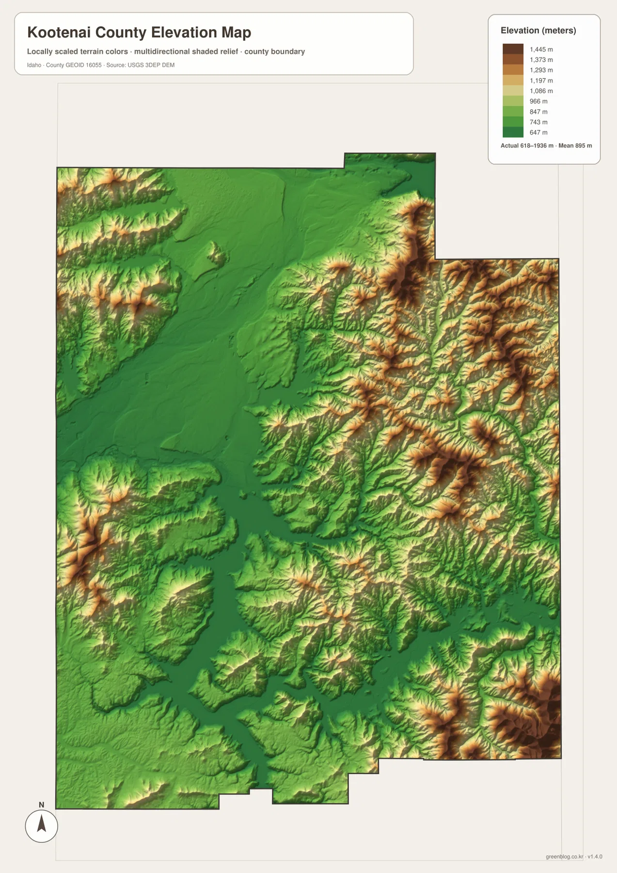
This is a generalized elevation surface intended to show broad relief, not survey-grade height at a building site or road point. The color classes make countywide differences easy to compare, but precise engineering, drainage, or construction work requires source elevation data and professional surveying. For ordinary map use, the main message is clear: the urban and lake basin is relatively low, while the eastern and southeastern county is much higher and more deeply divided by valleys.
Choosing the right file for roads, cities, waterways, or terrain
If you are new to Kootenai County, begin with the general county map. Locate I-90, US 95, Coeur d’Alene, Post Falls, and Lake Coeur d’Alene first; those references make nearly every other place on the page easier to understand. The ranked-city map is a good second step when the goal is to compare where the six highlighted cities sit without the distraction of smaller roads and place labels.
Use the terrain-and-water map when the lake, Spokane River, Coeur d’Alene River, mountain tributaries, or shoreline bays are the main subject. Switch to the elevation map when you need a quick picture of where the low basin gives way to high mountain ridges. Keeping those topics in separate files makes the labels easier to read and avoids turning one county map into an overloaded reference sheet.
The on-page WebP images are optimized for browsing, while the downloadable JPGs preserve more detail at 3638×2572 pixels each. The ZIP contains only the four map types described here. It does not include parcel boundaries, flood zones, live traffic, lake depth, or navigation information, so those needs should be handled with the appropriate official or specialized service.
Frequently Asked Questions
Which map is best for locating Coeur d’Alene and Post Falls along I-90?
The general county map is the most useful choice because it shows both cities together with I-90, US 95, the Washington state line, and nearby communities. The ranked-city map is cleaner if you only need the relative city positions, but the general map gives the road context needed to understand how the western corridor is connected.
Where can I see Lake Coeur d’Alene, the Spokane River, and the Coeur d’Alene River together?
Use the terrain-and-water map. It shows Lake Coeur d’Alene as the central water body, the Spokane River leaving the lake to the west, and the Coeur d’Alene River system entering from the mountainous east. It also labels several creeks and bays. For flood, depth, navigation, or real-time water information, use a separate official source because those topics are not part of this map.
What is the main elevation contrast in Kootenai County?
The broad lowlands around the lake and northwestern settlement area contrast with much higher, more rugged terrain in the east and southeast. The map summary gives an actual range of about 618–1,936 meters and a mean of 895 meters. Those values are useful for county-scale comparison, but the map is not a survey product for precise point elevations.
Map File Information
Download the high-resolution JPG maps for Kootenai County in one ZIP. Use these files when you need more detail than the WebP previews shown in the article.
- Included Files: general county map, ranked-city map, terrain-and-water map, elevation map
- Printable Size: 3638×2572 pixels per JPG
- File Type: ZIP containing 4 JPG images
Related Maps
Sources and references
County services and official local mapping resources are available from the Kootenai County official website. Current county statistics can be checked through U.S. Census Bureau QuickFacts: Kootenai County, Idaho.
For the underlying types of geographic data, see U.S. Census Bureau TIGER/Line Shapefiles for boundaries, USGS National Hydrography for rivers and streams, and the USGS 3D Elevation Program for elevation data.
Green Map creates custom-edited map images using open geographic data sources such as geoBoundaries, Natural Earth, OpenStreetMap, and government open data.
These maps are edited visual materials, not raw data files, and are provided for education, documents, presentations, and graphic reference.