Bonner County Map files can be downloaded here as high-resolution A3 JPGs in one ZIP, while the WEBP previews on the page make it easy to inspect the area before opening the larger files. The maps focus on Sandpoint, Lake Pend Oreille, Priest River, Clark Fork, major roads, waterways, and the strong elevation contrast between lake-and-river valleys and the surrounding mountains.
Bonner County stretches across northern Idaho’s panhandle and is shaped by water as much as by roads. Sandpoint, Ponderay, and Dover form a close cluster near Lake Pend Oreille, Priest River lies far to the west, and Clark Fork sits near the eastern side of the lake. The county also reaches north toward Priest Lake, while mountain terrain rises on both sides of the lower lake and river corridors.
Table of Contents
Use Sandpoint and Lake Pend Oreille as the main reference points
The easiest way to orient yourself is to find Sandpoint first. Bonner County’s official overview identifies Sandpoint as the county seat, and the map places it beside the northwestern side of Lake Pend Oreille. Ponderay sits just to the north, Dover is close to the southwest, and Kootenai appears a short distance east. This compact group provides a clear center before you look toward Priest River or Clark Fork.
The county boundary is unusually shaped. A long northwestern section reaches toward the Priest Lake area, while the central and eastern portions spread around Lake Pend Oreille and the surrounding mountains. The large step in the northern boundary and the southeastern bends around the lake make the outline easy to recognize once you have seen it a few times.
Places outside the county help with orientation as well. Bonners Ferry and Moyie Springs appear north of the boundary, while Spirit Lake and Athol are shown to the southwest. These surrounding names make it easier to see how Bonner County sits between Boundary County to the north and Kootenai County to the south within the Idaho Panhandle.
The main communities form a lake cluster and two outer centers
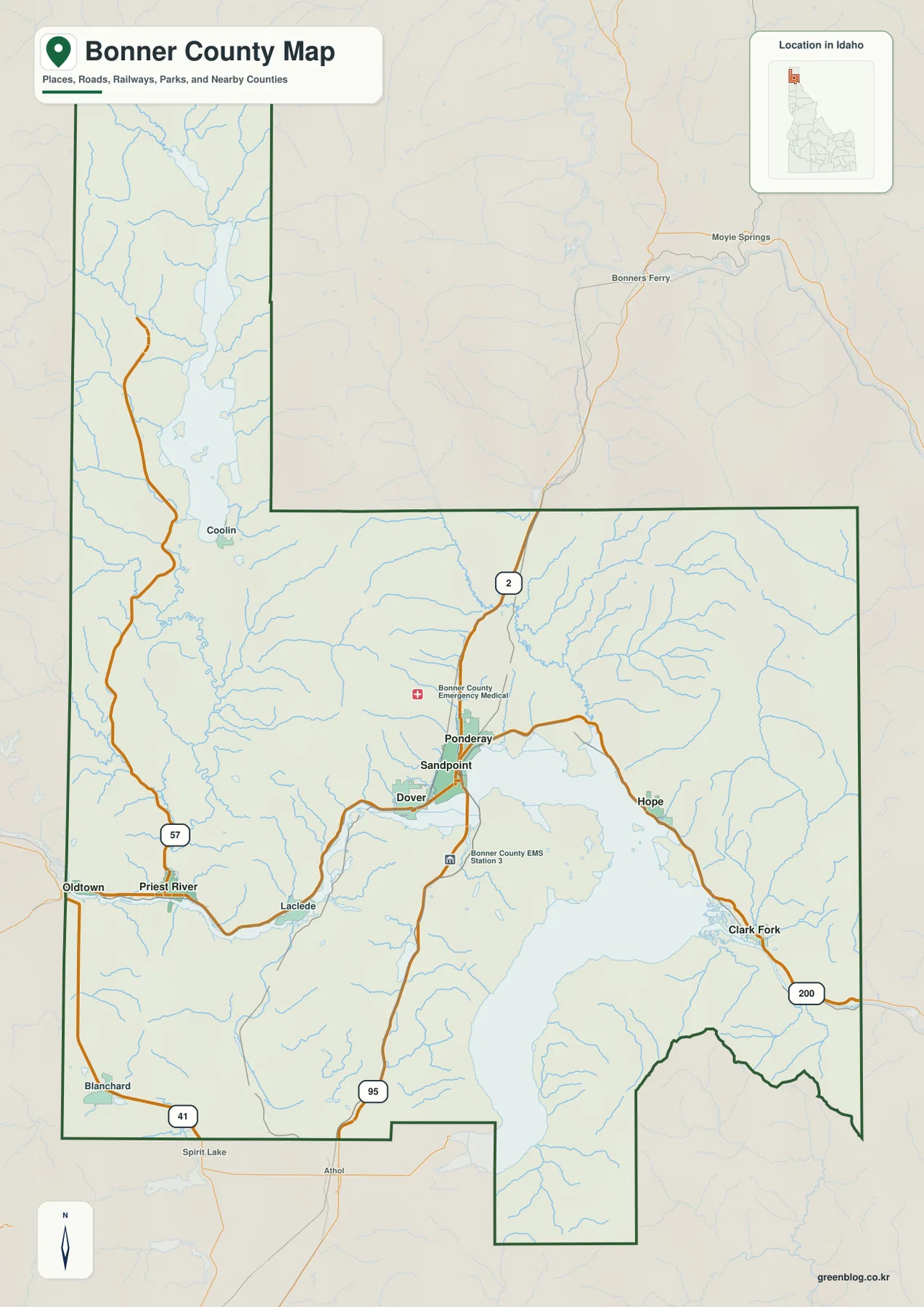
The city map highlights six ranked cities: Sandpoint, Priest River, Ponderay, Kootenai, Clark Fork, and Dover. Sandpoint ranks first in the supplied index, and several of the others sit close enough to form a compact group around the northern end of Lake Pend Oreille. Priest River and Clark Fork are different: each lies much farther from Sandpoint and serves as a useful reference point for the western and eastern sides of the county.
Ponderay is immediately north of Sandpoint, Dover is to the southwest, and Kootenai is nearby to the east. This close spacing makes the Sandpoint area look very different from the rest of the county. Priest River sits along the western river corridor, while Clark Fork is near the eastern approach to Lake Pend Oreille. The city map removes much of the terrain detail, so the spacing between these places is easier to compare than on the busier county overview.
The road network ties those settlement patterns together. US 95 passes through the Sandpoint area on its north-south route. US 200 runs along the north side of Lake Pend Oreille toward Hope and Clark Fork, and ID 57 heads north from Priest River toward Coolin and the Priest Lake area. The western edge near Oldtown and Blanchard has a different set of approaches than the Sandpoint lake corridor, which is why the overview map is useful for planning a route across the county rather than focusing on a single town.
Lake Pend Oreille links the county’s biggest rivers and mountain streams
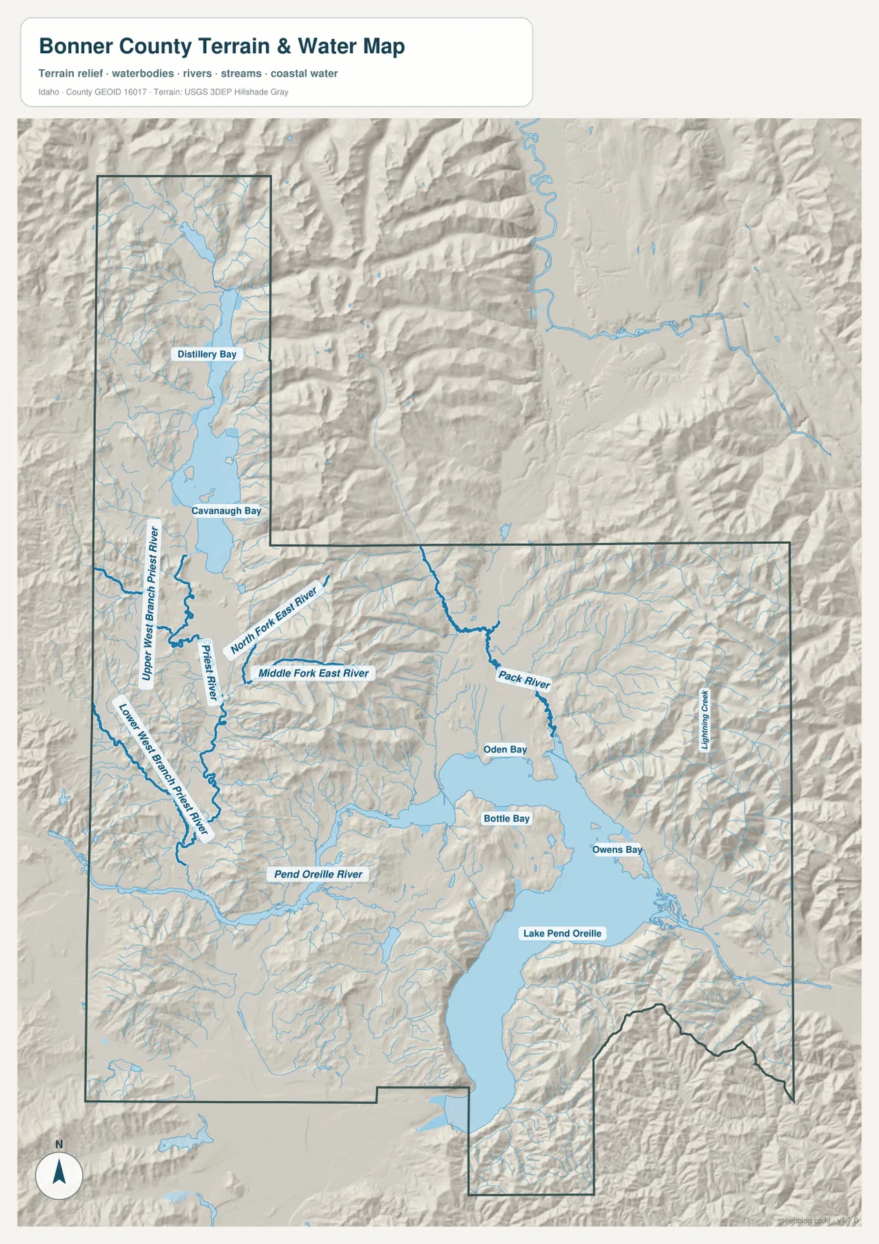
Water is the strongest visual feature on the terrain-and-water map. Lake Pend Oreille fills much of the central-eastern area, with Oden Bay and Bottle Bay labeled near its northwestern side and Owens Bay farther east. The Pend Oreille River leaves the lake toward the west, while Priest River comes down through the western part of the county before joining that larger river system.
The official Bonner County overview describes the same large-scale pattern. Clark Fork enters Lake Pend Oreille from the east, the Pend Oreille River drains the lake to the west, and Priest River carries water south from Priest Lake toward the Pend Oreille River. On the supplied map, the Priest River system includes named branches such as Upper West Branch Priest River and Lower West Branch Priest River, while the northern lake country includes Distillery Bay and Cavanaugh Bay.
North and east of Lake Pend Oreille, the drainage becomes more branched. Pack River flows toward the lake from the north, and Lightning Creek is labeled in the eastern mountains. Numerous smaller streams follow steep valleys on both sides of the county. That contrast between broad lakes and rivers in the lower areas and short mountain tributaries in higher terrain is one of the clearest geographic patterns in Bonner County.
This water map is a reference map rather than a flood, navigation, property, or legal-boundary product. It is best used to understand where the major lakes, rivers, bays, and mountain streams sit in relation to towns and terrain. Pairing it with the city map makes the relationship especially clear around Sandpoint, Priest River, and Clark Fork.
Elevation separates the lake basins from the surrounding ranges
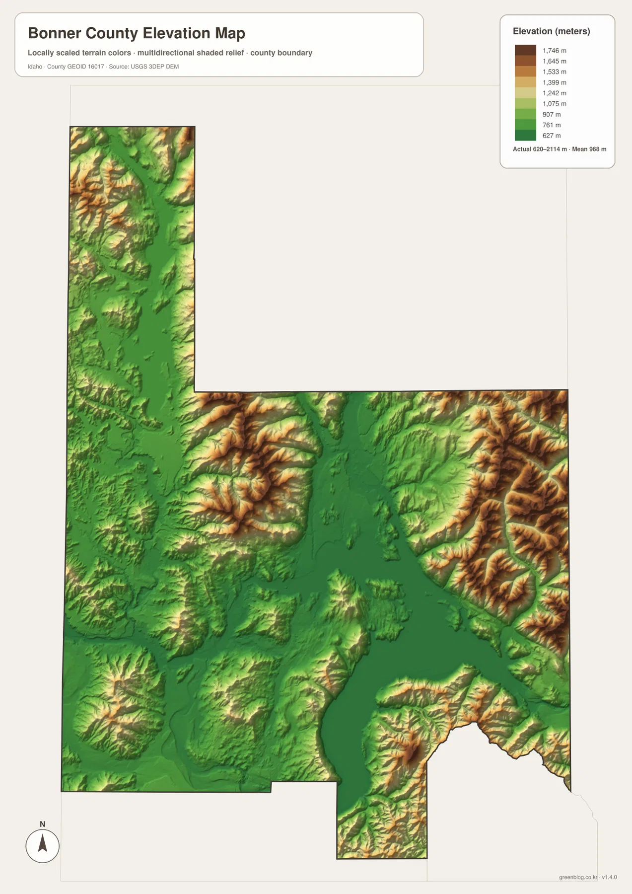
The elevation map makes the contrast between valleys and mountains much easier to see. Lake Pend Oreille, the Pend Oreille River corridor, and other low valleys appear in deep green. Higher land surrounds those corridors on both sides, with stronger tan and brown tones especially visible in the eastern and northeastern mountains.
Bonner County’s official description identifies the Selkirk Mountains on the west and the Cabinet Mountains on the east. The elevation view matches that broad setting: the county is not a flat lake district, but a landscape where large water bodies occupy lower basins between substantial mountain systems. The Priest Lake area in the northwest also sits within a narrow lower corridor bordered by rising terrain.
The map reports an actual elevation range of about 620 to 2,114 meters and a mean near 968 meters. The color scale is designed for county-wide comparison, not for engineering or survey work at a specific property. It is most useful for seeing why the Sandpoint and river corridors are relatively low while the eastern and western margins rise quickly into mountain country.
Choose the view that matches what you need to find
For general orientation, start with the county overview and locate Sandpoint, Lake Pend Oreille, Priest River, and Clark Fork. If you mainly need to compare communities, the city map is cleaner because it removes much of the surrounding detail. The terrain-and-water map is better for following rivers and lake arms, while the elevation map adds the vertical difference between the low basins and the mountain ranges.
Using the views together is useful for classroom work, travel planning, presentations, and regional comparisons. You can locate a city, follow the road that reaches it, identify the nearby river or lake, and then compare the surrounding elevation. That sequence is especially helpful in Bonner County because water, settlement, and mountain relief are closely connected rather than appearing as separate features.
Frequently Asked Questions
Where is Sandpoint on the Bonner County map?
Sandpoint is beside the northwestern side of Lake Pend Oreille, close to Ponderay, Dover, and Kootenai. It is the county seat and sits on the main road corridor, so it is a convenient starting point for finding Priest River to the west, Clark Fork to the east, and the northern lake country.
Which water features stand out most clearly?
Lake Pend Oreille is the largest feature on the map. The Pend Oreille River leaves the lake to the west, Priest River joins the western river system, and Pack River enters the lake from the north. The mountain areas also contain many smaller tributaries, bays, and streams.
What is the elevation map best used for?
It is best for comparing lower lake and river valleys with the higher mountain terrain on the county’s eastern and western sides. The generalized color surface is not a replacement for survey-grade elevation data at a specific site, but it gives a clear county-wide picture of relief.
Map File Information
The ZIP contains high-resolution A3 JPG versions of the Bonner County overview, city, terrain-and-water, and elevation maps shown as WEBP previews on this page.
- Included Files: county overview, city map, terrain and water map, elevation map
- File Type: four A3 JPG files in one ZIP archive
Related Maps
Sources and references
- Bonner County official website — About Bonner County
- U.S. Census Bureau TIGER/Line Shapefiles
- USGS National Hydrography
- USGS 3D Elevation Program
Green Map creates custom-edited map images using open geographic data sources such as geoBoundaries, Natural Earth, OpenStreetMap, and government open data.
These maps are edited visual materials, not raw data files, and are provided for education, documents, presentations, and graphic reference.