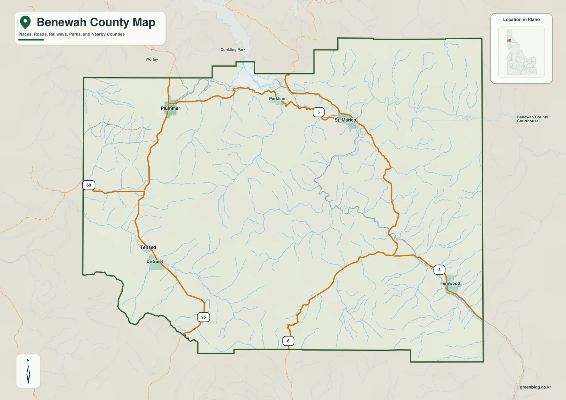
Download the Benewah County Map as one ZIP containing the high-resolution A3 JPG county, city-connections, terrain-and-water, and elevation maps. The same maps appear below as WEBP previews, so you can check St. Maries, Plummer, the St. Joe River, Chatcolet Lake, roads, and mountain relief on screen before opening the larger JPG files for printing, classroom use, reports, or presentations.
Benewah County lies in northern Idaho, and St. Maries is the most useful place to begin reading its geography. Roads approach the city from Plummer and Parkline to the west, while the St. Joe River and St. Maries River meet the surrounding low valleys nearby. Farther west are Plummer and Tensed, Fernwood sits toward the east, and the county rises into higher mountain terrain beyond the broad northern river-and-lake corridor.
The supplied maps work best as a sequence rather than as four unrelated pictures. The general map establishes boundaries, named places, and road directions; the simplified city view makes the spacing of the main communities easier to remember; the water map shows the river and lake system; and the elevation view explains why many of those routes and waterways follow valleys instead of crossing the highest ridges directly.
Table of Contents
St. Maries, Plummer, and the roads that organize the county map
On the general county map, St. Maries appears near the north-central part of Benewah County. A westward road corridor runs through Parkline toward Plummer, while Tensed and De Smet are labeled farther south along the western side. Fernwood is separated from those communities and appears in the eastern part of the county along Route 3. Route shields for 3, 5, 6, 60, and 95 give enough context to see the main travel directions without turning the map into a dense street atlas.
The boundary itself is irregular, especially along the north and the southwest, so a place can look close on the page while still being separated by a long road or a county edge. Kootenai County is shown to the north on the city view, Latah County to the west, and Shoshone County to the east. Reading the roads together with the boundary is therefore more useful than following a single highway line in isolation.
For a short explanation of the county, St. Maries, Plummer, Tensed, and Fernwood are enough to establish the main pattern. St. Maries functions as the clearest hub, Plummer anchors the west, Tensed extends the pattern toward the southwest, and Fernwood shows how settlement continues into the more mountainous eastern side. Smaller local roads and minor places still matter on the ground, but the general map is meant to provide county-scale orientation rather than turn-by-turn navigation.
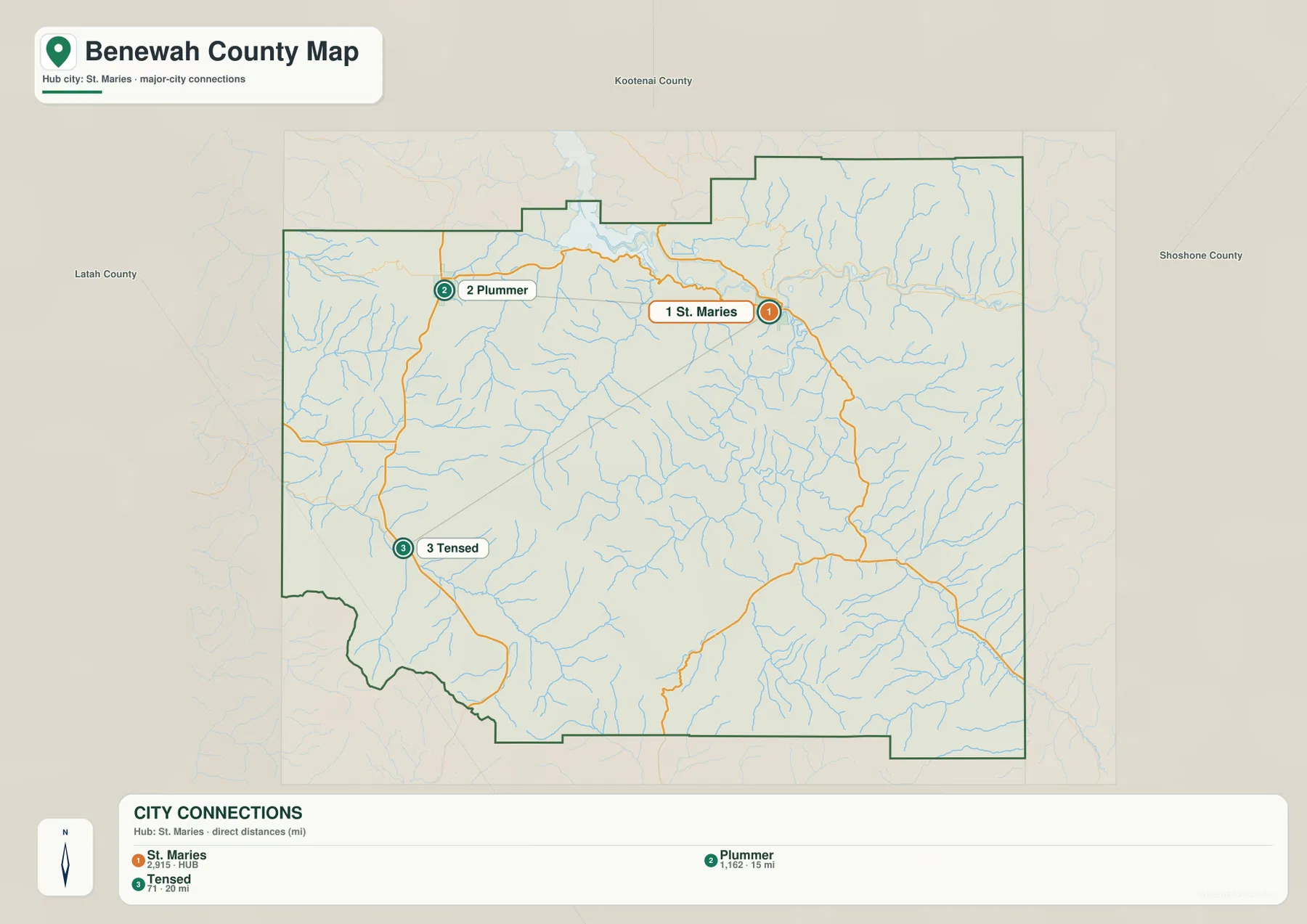
The city view makes the St. Maries–Plummer–Tensed spacing easy to compare
The city-connections map deliberately removes much of the extra labeling and emphasizes three places: St. Maries, Plummer, and Tensed. St. Maries is the hub, Plummer lies to the west, and Tensed is southwest. That simple arrangement is useful when you want a quick mental picture of the county before returning to the more detailed map.
The 15-mile and 20-mile figures shown for Plummer and Tensed are straight-line distances from St. Maries, not driving distances. Roads in Benewah County curve around water, ridges, and valleys, so an actual trip can be longer than the direct measurement suggests. Use a current road or navigation source when travel time matters; use this map when the goal is to compare relative position and distance.
This simplified view also says something about settlement. Benewah County does not have one continuous urban corridor filling the map from west to east. Instead, communities are separated by large rural and mountainous areas, and the road network connects them through a limited number of valleys. That makes the city map especially useful in a classroom or presentation where too many labels would distract from the basic county layout.
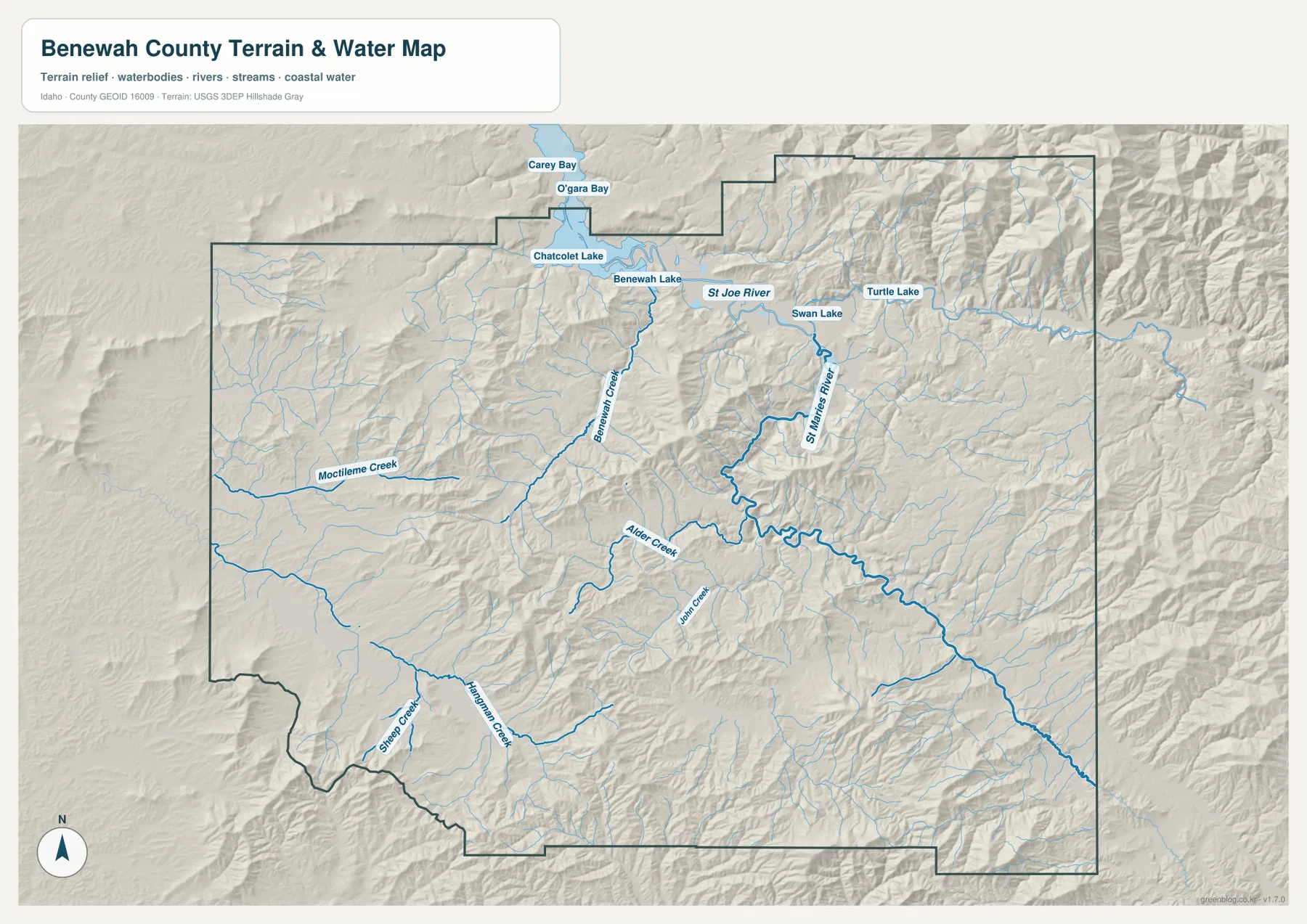
The St. Joe River and northern lakes form the county’s broadest water corridor
The terrain-and-water map gives the northern part of the county a very different appearance from the mountain interior. The St. Joe River runs across the north, passing a chain of wider water bodies that includes Chatcolet Lake and Benewah Lake. Carey Bay and O’gara Bay are labeled near the northern edge, while Swan Lake and Turtle Lake appear farther east along the same general lowland corridor.
South of the St. Joe River, the St. Maries River and smaller tributaries cut through narrower valleys. Benewah Creek and Alder Creek are labeled clearly, and the shaded relief shows how those streams occupy lower ground between ridges. The result is not a simple north-to-south drainage grid: broad water and lake areas dominate the north, while smaller branching channels become more common through the central and southern mountain terrain.
Reading this map beside the road map helps explain why transportation corridors often bend instead of following straight compass directions. Valleys provide lower routes through the relief, and both roads and streams frequently share those corridors. The map is a geographic reference, however, not a flood map, parcel map, boating chart, or statement about legal access. Current agency information should be used for flood risk, navigation, ownership, or water-safety decisions.
Mountain relief rises well above the northern river and lake lowlands
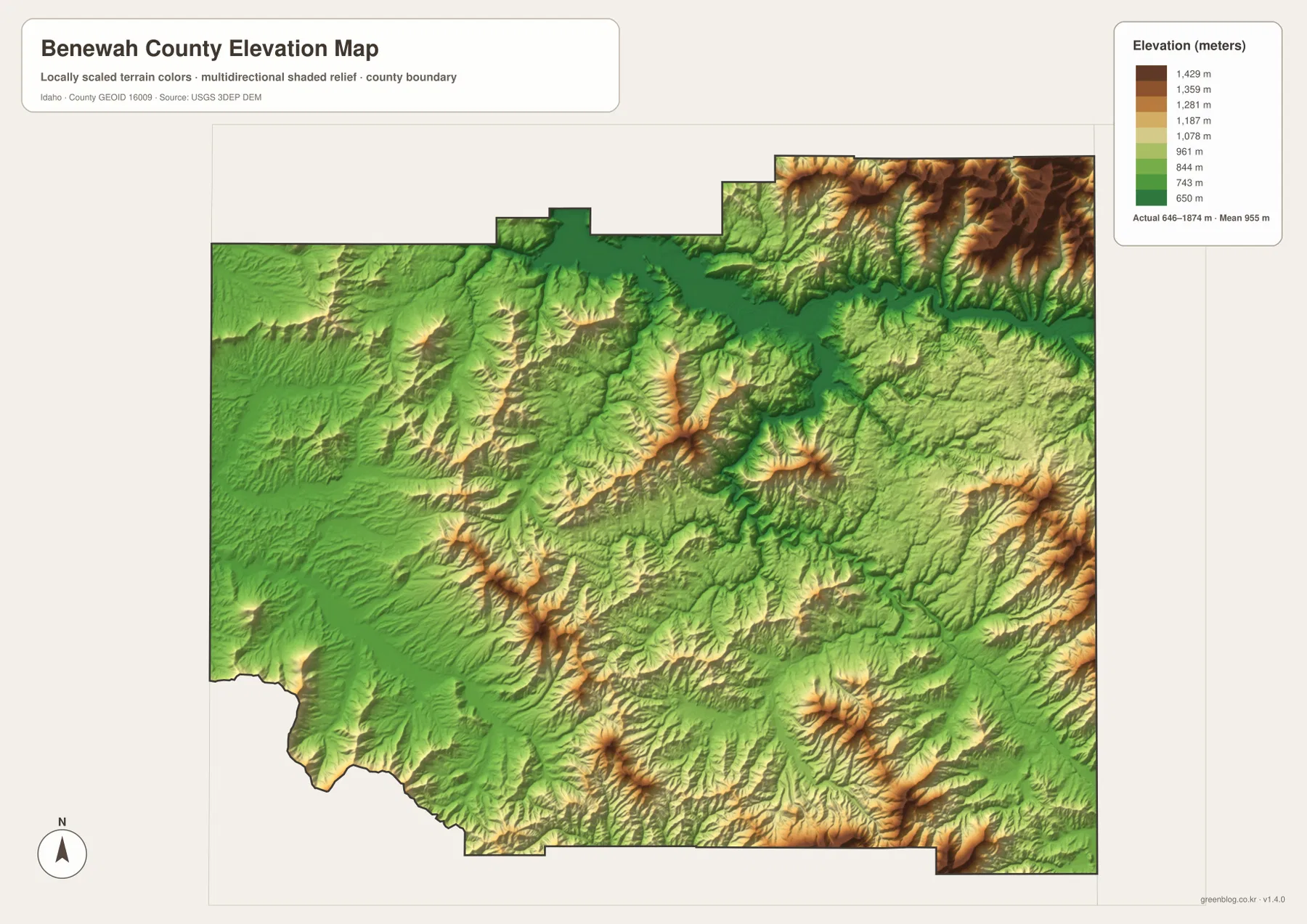
The elevation map uses lower green tones through much of the northern river-and-lake corridor, then shifts toward yellow and brown as the land rises. The most obvious high terrain appears along the northeastern edge, with additional high ridges in the southeast and across parts of the interior. Western Benewah County is generally lower, although the shaded surface still shows rolling terrain and smaller ridges rather than a broad flat plain.
The legend reports an actual elevation range of about 646 to 1,874 meters and an average near 955 meters. A vertical difference of more than 1,200 meters within one county is large enough to influence road placement, settlement, and drainage. St. Maries and the northern lakes occupy comparatively low terrain, while the higher northeastern and southeastern ridges create the mountain backdrop visible on the terrain-and-water map.
This is a generalized county-scale elevation surface, so it is appropriate for comparing broad relief but not for engineering or parcel-level measurement. The edge of a color band should not be interpreted as the exact elevation of a house site, road cut, or property corner. For detailed work, consult current USGS elevation products or survey-grade information appropriate to the project.
Choose a map by the question you need to answer
Use the general map when you need the county boundary, named communities, and main road directions. The city map is faster for explaining the relative position of St. Maries, Plummer, and Tensed, while the water map is better for tracing the St. Joe River, St. Maries River, northern lakes, and tributaries. Add the elevation view when you want to show why rivers and roads tend to occupy certain valleys or why the eastern parts of the county feel more mountainous.
For a classroom exercise, start with the settlement map and ask students to locate St. Maries before adding rivers and relief. For a printed reference sheet, pair the general map with either the water or elevation map depending on the topic. The WEBP images are convenient for on-screen comparison, and the A3 JPG files in the download archive provide the larger format needed for print, handouts, or detailed slides.
Frequently Asked Questions
What is the easiest place to use as a reference point on a Benewah County map?
St. Maries is the clearest starting point. It sits near the north-central part of the county, close to the St. Joe and St. Maries river corridors and several major road connections. Once St. Maries is located, Plummer and Tensed are easy to place to the west and southwest, while Fernwood lies farther east.
Do the 15-mile and 20-mile labels show driving distance?
No. They are straight-line distances from St. Maries to Plummer and Tensed. Actual driving routes can be longer because roads follow valleys, rivers, and mountain terrain rather than the shortest possible line. Use a current navigation source for trip planning.
Which maps best explain the relationship between the St. Joe River and the mountains?
Compare the terrain-and-water map with the elevation map. The first identifies the St. Joe River, the St. Maries River, northern lakes, and branching tributaries; the second shows that the broad northern water corridor is generally lower than the higher terrain in the northeast and southeast. Together they make the valley-and-ridge relationship much easier to see.
Map File Information
Download the supplied Benewah County map subjects as high-resolution A3 JPG files in one ZIP. The archive matches the WEBP previews on this page and is intended for printing, classroom material, reports, and presentations.
- Included Files: A3 JPG originals matching the supplied map subjects
- File Type: ZIP containing JPG files
Related Maps
Sources and Reference Data
- Benewah County official website – county government and local background information
- U.S. Census Bureau TIGER/Line Shapefiles – administrative boundaries and road data
- USGS National Hydrography – rivers, lakes, and hydrographic data
- USGS 3D Elevation Program – elevation data
Green Map creates custom-edited map images using open geographic data sources such as geoBoundaries, Natural Earth, OpenStreetMap, and government open data.
These maps are edited visual materials, not raw data files, and are provided for education, documents, presentations, and graphic reference.