Van Buren County lies in north-central Arkansas, where Clinton occupies a central road junction among deeply cut Ozark hills. Fairfield Bay and Shirley sit to the east, Damascus is in the long southern section, and Dennard lies in the northern extension. The Little Red River and its forks cross broad parts of the county, while the highest ground is concentrated mainly in the north and northwest.
Download the original high-resolution A3 JPG files from this Van Buren County Arkansas Map set in one ZIP near the end of the page. The package contains a county reference map, city map, terrain-and-water map, and elevation map. Begin with Clinton for roads and place names, then compare the Little Red River valleys with the elevation view to see how sharply the lower river corridors differ from the surrounding Ozark ridges.
Table of Contents
Clinton is the best reference point for roads and local places
On the county reference map, Clinton appears slightly east of center with the Van Buren County Courthouse and a medical facility labeled nearby. Several roads converge in the same area. Highway 95 crosses through Clinton, Highway 9 continues south, and Highway 16 provides a connection toward Shirley in the northeast. That combination makes Clinton the easiest place to use when establishing the county’s basic directions.
East of Clinton, the road network leads toward Shirley and Fairfield Bay. Routes 330 and 337 appear around Fairfield Bay, where the mapped developed area is broader than in many other eastern locations. South of Clinton, Bee Branch and Damascus provide useful landmarks, with Routes 92, 65, 285, and 124 helping define the long southern portion of the county.
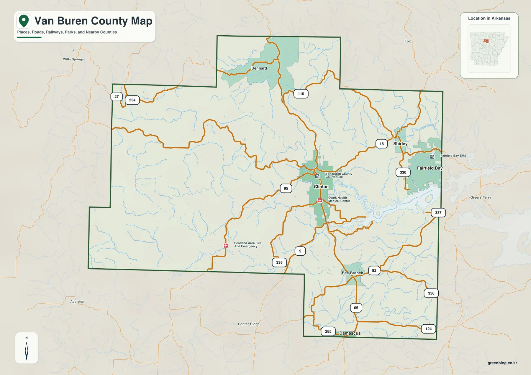
The northern extension looks much more rural. Dennard is the main labeled place there, and Highway 110 runs south from the area toward the county interior. Along the northwestern edge, Routes 27 and 254 are visible but large town labels are absent. This contrast between the central-east settlement pattern and the sparsely labeled western uplands is one of the clearest features on the county map.
Fairfield Bay is close to Clinton and Shirley, while Damascus is farther south
The city map uses Fairfield Bay as its hub and compares it with Clinton, Shirley, and Damascus. In the supplied graphic, Fairfield Bay and Clinton are shown with similar population values, while Shirley and Damascus are much smaller. Their positions are more useful than the ranking alone: Fairfield Bay is in the east, Clinton is closer to the center, Shirley is just to the north, and Damascus is well to the south.
The connector distances in this graphic are straight-line distances, not driving distances. The map shows approximately 11 miles from Fairfield Bay to Clinton, 3 miles to Shirley, and 18 miles to Damascus. Mountain roads and indirect routes can make actual travel longer, so the county reference map should be used when following roads rather than treating these connectors as driving routes.
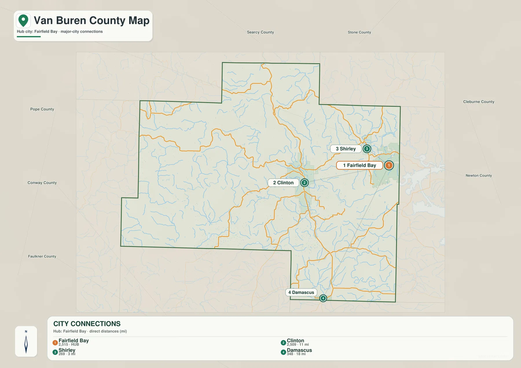
The numbers printed on the city graphic should be treated as comparison values in the supplied image rather than a substitute for current Census estimates. The map’s main purpose is geographic: it shows how the principal communities relate to one another and makes the close spacing of Fairfield Bay, Shirley, and Clinton easier to see.
The Little Red River system occupies the county’s largest valleys
The terrain-and-water map is dominated by the Little Red River system and the valleys feeding it. The Little Red River bends across the eastern part of the county, while the Middle Fork Little Red River runs through the northeast. The South Fork Little Red River appears farther west and joins a broader network of tributaries through the center. These watercourses create long low corridors through otherwise rugged terrain.
Several smaller named streams help show how dense the drainage network is. Archie Creek crosses the north-central interior, while Big Branch and West Creek descend through the northeastern hills. Pigeon Creek and Lynn Creek are labeled in the northern extension. Farther south, Choctaw Creek runs through the central-southern area, and the North Fork Cadron Creek appears in the southeastern section.
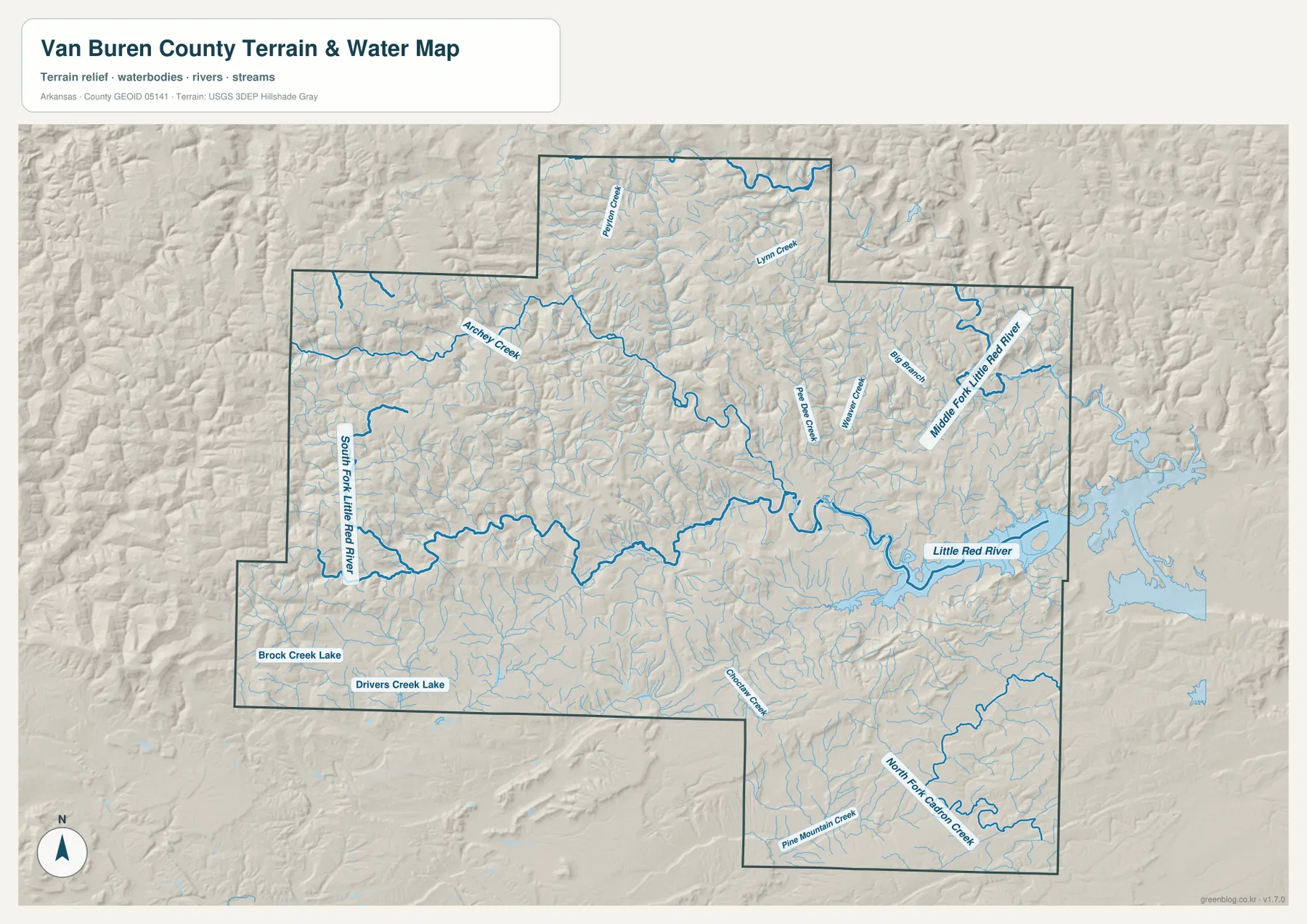
Brock Creek Lake and Drivers Creek Lake are labeled in the southwest, adding small lake landmarks to a map otherwise dominated by branching streams. Pine Mountain Creek is visible near the southern edge. Comparing these water features with the shaded relief shows that most channels occupy lower paths between ridges rather than crossing the highest ground directly.
This is a county-scale water reference, not a flood-hazard, parcel, navigation, or water-quality map. It is useful for locating streams and lakes and for explaining how valleys cut through the hills. Decisions involving safety, legal boundaries, or current water conditions require specialized up-to-date information from the responsible agencies.
The northwestern uplands rise well above the Little Red River valleys
The elevation map shows an actual range of about 119 to 609 meters, with a mean near 303 meters. The highest brown terrain is concentrated mainly across the northwest and north, where repeated ridges and narrow valleys create a strongly textured surface. In contrast, the Little Red River corridor through the center and east appears as a long green band of lower ground.
Clinton occupies an intermediate position between the highest western ridges and the lower river corridor to the east. Fairfield Bay is also close to lower terrain associated with the river system. Moving north toward Dennard, the hills rise again and the higher colors become more extensive. The western edge contains some of the strongest high-elevation colors in the county.
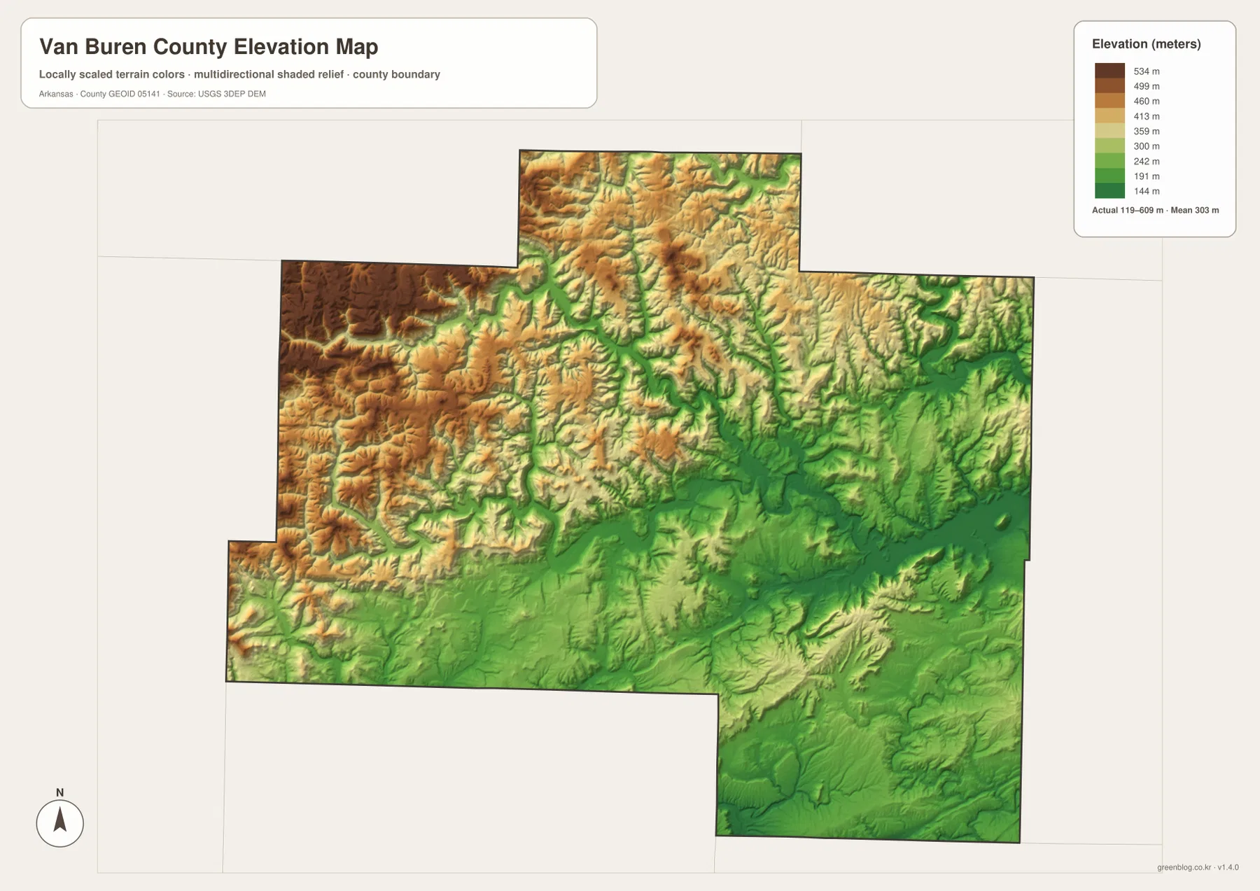
The southern extension is lower than the strongest northwestern highlands but still contains repeated hills and narrow valleys. On the water map, the North Fork Cadron Creek and Pine Mountain Creek occupy some of those lower corridors; the same paths appear greener on the elevation image. Reading the two views together makes the ridge-and-valley structure much easier to understand.
The elevation colors are intended for broad county comparison rather than property-level measurement. They can show which parts of Van Buren County are higher or lower, but they should not be used for construction, drainage design, parcel elevation, or exact slope calculations. Detailed USGS 3D Elevation Program data or professional measurements are better choices when precision is required.
Use Clinton and the Little Red River to establish direction
A simple way to read the county is to find Clinton first and then trace east toward Shirley and Fairfield Bay. Once the Little Red River is located, the lower eastern valley becomes easy to recognize. From Clinton, Highway 9 leads the eye south toward Bee Branch and the long Damascus section, while Highway 110 provides a useful route marker for the northern extension near Dennard.
The water map adds a second layer of orientation. The Middle Fork Little Red River helps identify the northeast, the South Fork marks a major western-central valley, and the North Fork Cadron Creek belongs to the southern part of the county. Switching to the elevation image after locating those waterways shows how each stream follows lower ground between the hills.
Neighboring county labels provide additional context. Pope County lies to the west and northwest, Searcy County to the north, Stone County to the northeast, Cleburne County to the east, Faulkner County to the south, and Conway County to the southwest in the supplied map context. Use the dark county boundary to separate those outside labels from features located inside Van Buren County.
Choose the map according to whether you need roads, water, or terrain
The county reference map is the best starting point for Clinton, Fairfield Bay, Shirley, Damascus, Dennard, roads, facilities, and nearby counties. The city map is cleaner when the goal is to compare the main communities and their straight-line spacing. The terrain-and-water image is better for the Little Red River system and its tributaries, while the elevation map clearly separates the high northwestern uplands from the lower river valleys.
Using two maps together can make a lesson or regional explanation more useful. Pair the county and elevation views to show where Clinton and Fairfield Bay sit relative to the lower river corridor. Pair the water and elevation images for Dennard and the western uplands to show how small creeks occupy narrow valleys between much higher ridges.
Each downloadable JPG measures 3638 × 2572 pixels and is suitable for A3 landscape printing, zooming into labels, or placing a map in a report or classroom handout. Keep the original aspect ratio when resizing so roads, streams, and the county boundary are not stretched. Printer margins vary, so a test print is useful before producing multiple copies.
Frequently Asked Questions
Where is Clinton within Van Buren County?
Clinton is slightly east of the county’s center and is the strongest road and administrative reference point on the supplied map. The Van Buren County Courthouse is labeled there, and the main roads connect outward toward Fairfield Bay, Shirley, Damascus, and the northern part of the county.
Where does the Little Red River run through the county?
The Little Red River occupies a large valley through the central and eastern part of Van Buren County. The Middle Fork and South Fork are also prominent on the terrain-and-water map. Their valleys appear lower than the surrounding Ozark ridges on the elevation view.
Are the city-map distances driving distances?
No. The supplied city graphic labels direct, straight-line distances from Fairfield Bay to Clinton, Shirley, and Damascus. Actual driving distances can be longer because roads bend through hilly terrain.
Map File Information
The ZIP contains the original Van Buren County reference, city, terrain-and-water, and elevation maps as high-resolution JPG files.
- Included Files: County reference map, city map, terrain-and-water map, elevation map
- Printable Size: 3638 × 2572 pixels each
- File Type: Four high-resolution JPG files in one ZIP archive
Related Maps
Sources and References
- U.S. Census Bureau TIGER/Line – Official geographic data information for county boundaries, roads, and related mapping layers.
- USGS National Hydrography – Official information about U.S. rivers, streams, lakes, and hydrographic data.
- USGS 3D Elevation Program – Official elevation and terrain data information.
Green Map creates custom-edited map images using open geographic data sources such as geoBoundaries, Natural Earth, OpenStreetMap, and government open data.
These maps are edited visual materials, not raw data files, and are provided for education, documents, presentations, and graphic reference.