Tripp County covers a large part of south-central South Dakota, with Winner near the middle of the county’s main road network and a landscape that changes noticeably from the lower White River country in the north to higher ground across the south. This page brings together the county reference map, a simplified Winner-centered city connection map, a terrain-and-water view, and an elevation map. The original A3 high-resolution JPG files for all four maps are available together in the download box below, so readers who need larger labels or printable copies do not have to rely on the smaller WebP previews.
The official Tripp County overview identifies Winner as the county seat and notes that the county was created in 1873 and organized in 1909. U.S. Census Bureau QuickFacts lists 1,612.46 square miles of land for 2020 and a population density of 3.5 people per square mile. Those figures fit what the maps show: communities and major highways are easy to pick out because they are separated by broad areas of creeks, rolling uplands, and open country rather than by continuous urban development.
Table of Contents
Winner gives the clearest starting point for a county with an irregular northern edge
Winner is not simply the largest label on the page; it is the most useful orientation point. Hamill lies to the northeast, Colome to the southeast, New Witten to the west, and Ideal farther north in the interior. Once those four directions are established, the unusual county outline also becomes easier to understand. The north side bends repeatedly, the eastern boundary has a pronounced inward step, and long sections of the west and south are comparatively straight. A list of place names does not show those relationships nearly as well as the full boundary.
The northern part of the county also looks different from the south in physical geography. The White River and its tributaries occupy lower, more dissected country, while the southern half rises into broader uplands cut by the Keya Paha River and smaller valleys. That difference matters when using the road map because two places that look close on a countywide page can still be separated by winding roads and changing terrain. The maps are therefore best used for orientation and regional comparison, not for estimating current travel time.
SD 44 crosses Winner while Colome connects US 18 with the eastern north-south routes
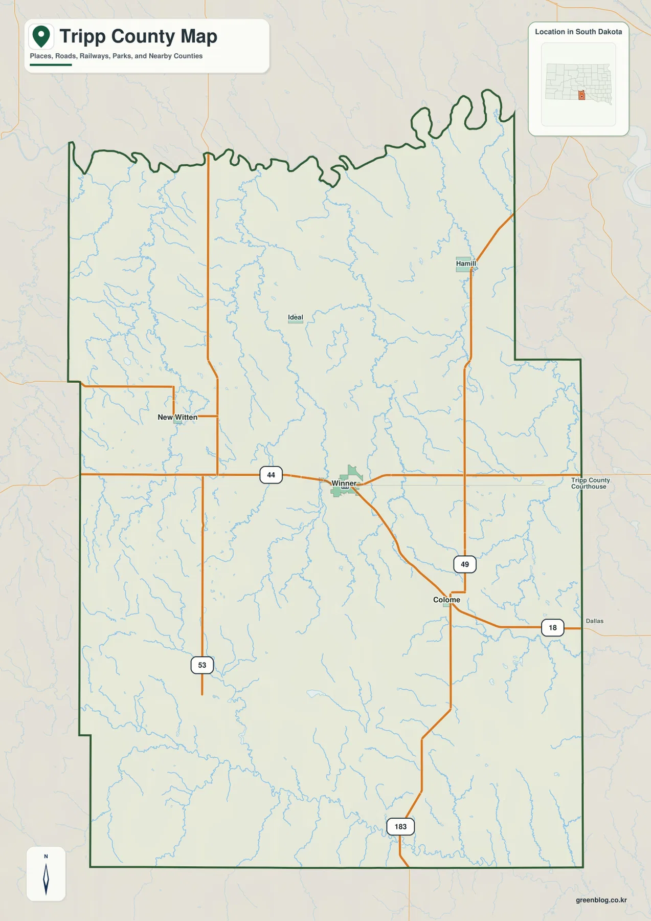
SD 44 is the most obvious east-west route on the general map. It approaches from the west near New Witten, passes directly through Winner, and continues toward the eastern side of the county. A road branches southeast from Winner to Colome, where the pattern changes again: US 18 continues east toward Dallas beyond the county line, while SD 49 runs north past the Hamill area. This makes Colome important for understanding the eastern road pattern even though Winner remains the main county reference point.
On the west side, SD 53 forms another long north-south line. US 183 leaves the county to the south, and Ideal sits north of Winner away from the most prominent highway corridor. Looking at the whole map makes it clear that Tripp County does not rely on one single cross-shaped highway junction. Instead, Winner anchors the central east-west route while separate north-south roads serve the western and eastern parts of the county.
This map is a geographic reference rather than a navigation product. It does not show live construction, seasonal restrictions, current road conditions, or every local road. The South Dakota Department of Transportation map collection should be used for current official road information, while administrative or legal boundary work requires authoritative geographic data such as current Census Bureau TIGER/Line files.
The Winner connection map puts Colome 11 miles southeast and New Witten 12 miles to the west
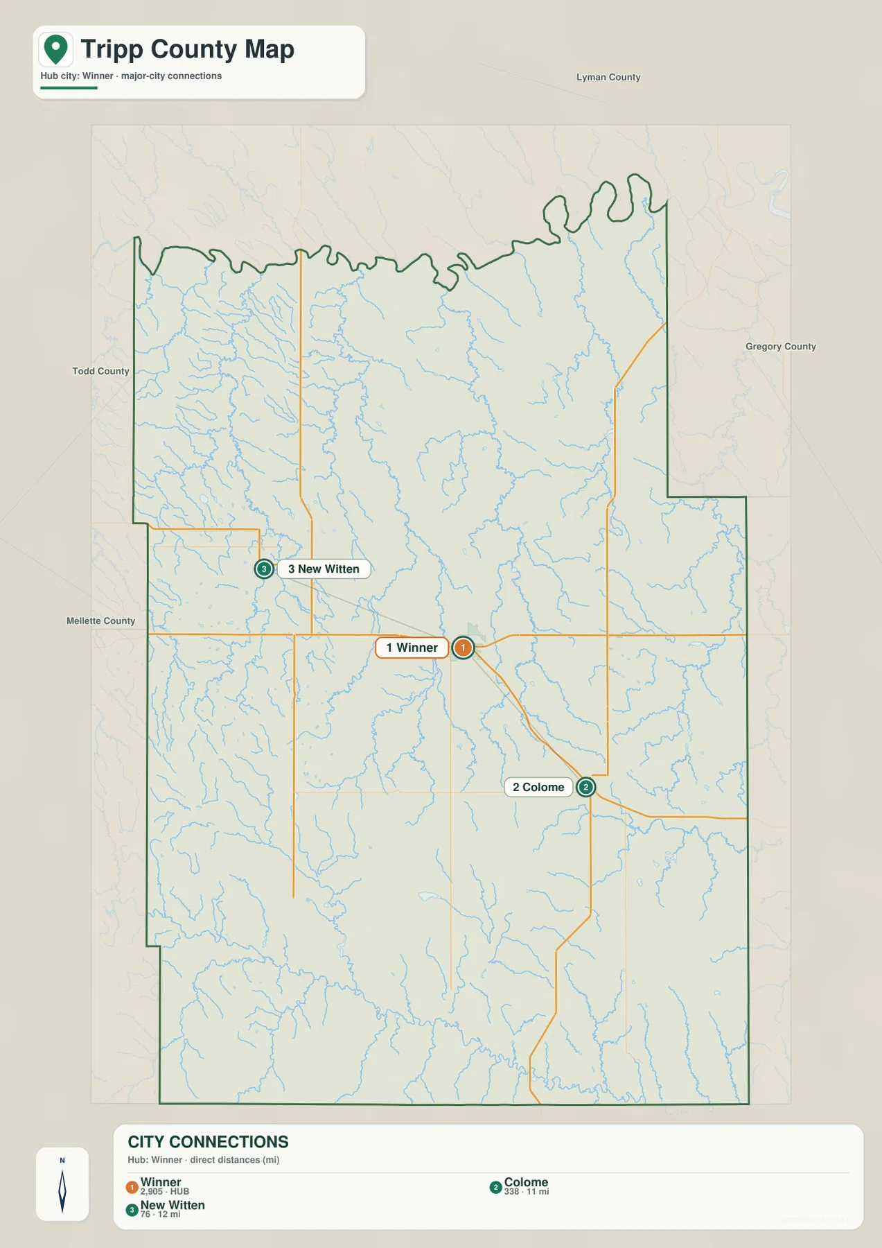
The city connection view strips away many of the labels found on the general map and focuses on three places. Winner is the hub, Colome is the second marker, and New Witten is the third. The index displays values of 2,905 for Winner, 338 for Colome, and 76 for New Witten. Those numbers belong to the ranking layer used in this map and should not automatically be treated as the newest population estimates. Anyone comparing current population should use an up-to-date demographic source instead.
The more useful feature here is distance and direction. Colome is marked 11 miles from Winner, while New Witten is 12 miles away. These are direct, straight-line distances between mapped points, not mileage driven on the road network. Colome sits southeast of Winner and New Witten sits to the west with a slight northern offset, so the nearly equal numbers represent two very different trips. Actual driving mileage can be longer because roads curve, intersect, and approach each community from specific directions.
This cleaner map works well in a presentation that only needs to explain Winner’s relationship to two nearby communities. It should not be mistaken for a complete list of Tripp County settlements. Hamill and Ideal remain important labels on the general map even though they are not included in the three-place connection layer. For a countywide discussion, use the two views together rather than asking the simplified version to carry every road and place name.
White River and Keya Paha River frame a county crossed by Dog Ear, Thunder, and Sand creeks
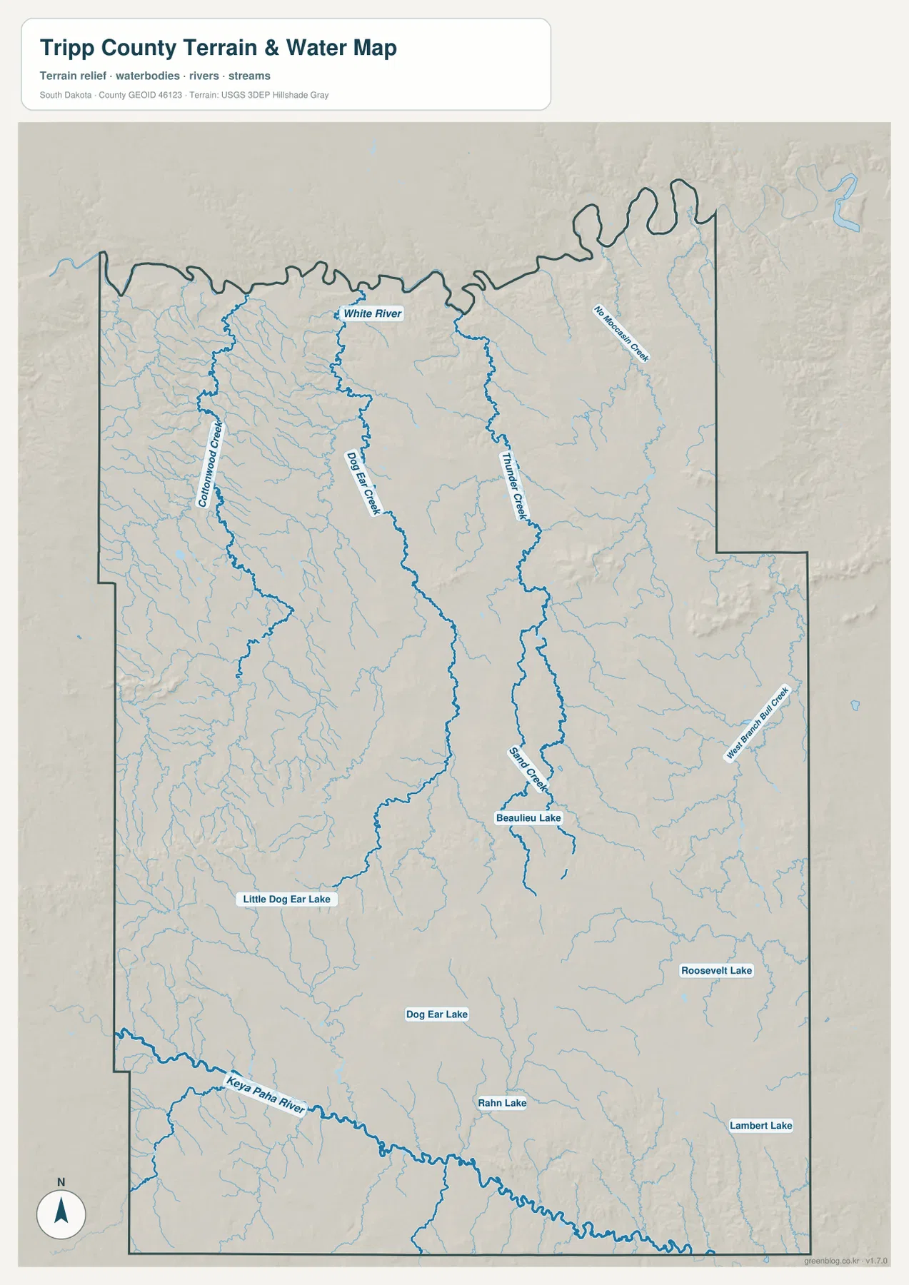
The water map changes the character of the county completely. Instead of highways, the strongest lines are the White River in the north and the Keya Paha River near the southern edge. Between them, Dog Ear Creek and Thunder Creek run through the interior, with Sand Creek farther south. Cottonwood Creek is labeled in the northwest and West Branch Bull Creek appears on the eastern side. Many thinner unnamed channels fill the spaces between these larger named features, showing how extensively the county is divided by local drainage.
The lakes are much smaller and more scattered than the river system. Beaulieu Lake lies somewhat south of the county center. Little Dog Ear Lake and Dog Ear Lake appear farther west and southwest, Rahn Lake is in the south, and Roosevelt Lake and Lambert Lake are labeled in the southeast. At a county scale, those isolated lakes do not dominate the landscape. The more important visual pattern is the combination of major rivers, narrow creek valleys, and many branching tributaries.
This layer answers location questions, not safety or access questions. It does not contain current streamflow, flood probabilities, water depth, water quality, fishing regulations, public-access rules, or property ownership. Anyone planning activity near the White River, Keya Paha River, or a named lake should check current USGS and relevant state or local information. The map is most useful for finding where a feature lies and how it relates to the surrounding terrain.
Elevation rises from lower northern valleys into broad southern uplands across a 430–804 meter range
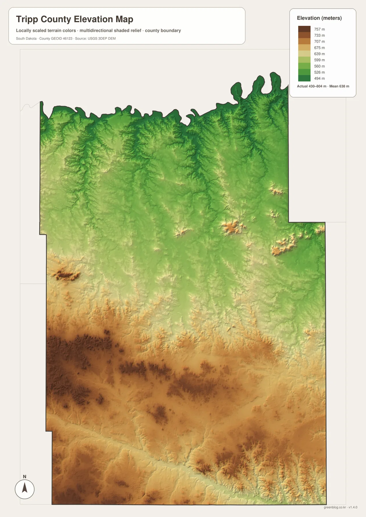
The elevation legend gives an actual mapped range of about 430 to 804 meters and a mean near 638 meters. Green colors cover much of the north, while yellow and brown tones spread across the central and southern parts of the county. The broadest high-elevation colors occupy the southwest and south. That change is one of the clearest physical features in the entire map set because the road map alone gives little indication of how much the county rises toward its southern half.
The northern section is still far from flat. Narrow valleys and small ridges are especially visible near the White River country, and isolated higher patches appear in the northeast and east-central areas. In the south, the average ground is higher, but creek and river valleys cut lower corridors through the uplands. The Keya Paha River follows one of those lower zones near the southern margin, while interior tributaries occupy smaller branching valleys.
Placing the elevation and water views side by side makes these relationships easier to understand. Dog Ear Creek and Thunder Creek follow lower channels through the interior, while the higher colors rise around them. That is useful for a school geography project or general regional reference, but it is not sufficient for engineering or surveying. The elevation surface is derived from USGS 3DEP data and is intended for broad comparison; exact site elevations, slopes, and grades require the original dataset and purpose-specific professional measurements.
Use the road view for orientation and the water or elevation views when physical geography matters
For a quick explanation of where Winner, Colome, New Witten, Hamill, and Ideal sit, the general reference map is the best starting point. The city connection view is more efficient when the only question is how Colome and New Witten relate to Winner. The water map is the clearest choice for White River, Keya Paha River, Dog Ear Creek, Thunder Creek, and the named lakes. When the subject is relief, the elevation view shows the north-to-south difference immediately without the distraction of road labels.
The WebP versions in the article are optimized for fast on-page viewing. The downloadable archive contains the same four maps as original portrait A3 JPG files, each measuring 2572×3638 pixels. Those larger files are better for printing, classroom handouts, presentations, detailed label reading, or personal reference. They remain general-purpose maps, however, so legal boundaries, road operations, flood conditions, navigation, and survey-grade elevation decisions should always be checked against current official data.
Frequently Asked Questions
Are the 11 miles from Winner to Colome and 12 miles to New Witten driving distances?
No. They are direct straight-line distances between the mapped points. Driving mileage follows the road network and can be longer, so current routing tools or official road maps should be used for travel planning.
Why are Hamill and Ideal absent from the Winner city connection map?
The connection layer is deliberately limited to Winner, Colome, and New Witten. Hamill and Ideal are visible on the general county map, and their absence from the simplified layer does not mean they are outside the county or unimportant. Use the general map when a broader settlement view is needed.
Can the 430–804 meter elevation range or water map be used for surveying or flood decisions?
No. The elevation layer is a generalized countywide reference and the water layer shows locations of rivers, creeks, and lakes. Precise surveying requires original elevation data and professional measurements, while flood or stream-condition decisions require current hydrologic and agency information.
Map File Information
The archive contains the Tripp County general map, Winner city connection map, terrain-and-water map, and elevation map as high-resolution A3 JPG files.
- Included Files: 4 JPG maps
- Printable Size: 2572×3638 pixels each
Related Maps
Sources and References
- Tripp County – About: county history and Winner county-seat background
- U.S. Census Bureau QuickFacts – Tripp County, South Dakota: land area and population-density reference
- South Dakota Department of Transportation – Maps: official South Dakota road and transportation map resources
- U.S. Census Bureau TIGER/Line Shapefiles: authoritative county boundary and geographic data
- USGS National Hydrography: rivers, creeks, lakes, and hydrographic reference data
- USGS 3D Elevation Program: source reference for county elevation data
Green Map creates custom-edited map images using open geographic data sources such as geoBoundaries, Natural Earth, OpenStreetMap, and government open data.
These maps are edited visual materials, not raw data files, and are provided for education, documents, presentations, and graphic reference.