This Brookings County Map page is built for readers who want both a clear county-scale reference and downloadable map files. Brookings County lies in eastern South Dakota, where the city of Brookings provides the strongest orientation point for roads, settlements, and the Big Sioux River corridor. I-29 runs north-south beside Brookings, US 14 connects the Volga side with Brookings, Aurora, and Elkton, and the county’s lakes and streams become much easier to understand when the road map is compared with the water and elevation views. The original high-resolution JPG maps shown here are available together in a ZIP download below.
A useful way to read the county is to begin with Brookings and then move outward. Volga sits to the west, Aurora to the east, and Elkton near the southeastern side of the county, while White and Bruce are farther north. The Big Sioux River follows a broad central route through the county, with Lake Poinsett and Lake Oakwood toward the northwest, Oak Lake in the northeast, and Lake Campbell near the southern edge. The elevation view adds another layer: much of the central corridor is lower, while the northeastern and eastern terrain rises noticeably higher.
Table of Contents
Brookings, Volga, and the road pattern along I-29 and US 14
The general county map makes Brookings the easiest place to locate. Its built-up area is the largest shown in the southern half of the county, and I-29 passes immediately along the city’s eastern side before continuing north. US 14 crosses the same part of the county from west to east, linking the Volga side with Brookings and continuing toward Aurora and Elkton. A rail line is also drawn through this southern belt, so the map shows several transportation features converging around the county’s main population center without implying that every local road follows the same pattern.
South Dakota State University is labeled within Brookings, giving the city another recognizable landmark on the map. North of the busier southern corridor, Bruce appears in the northwestern portion of the county and White in the northeast. Smaller place labels, including Bushnell and several colony names, appear on the general map even though they do not belong to the ranked six-city view. That makes this map the better choice when a reader wants county-wide orientation rather than only the largest communities.
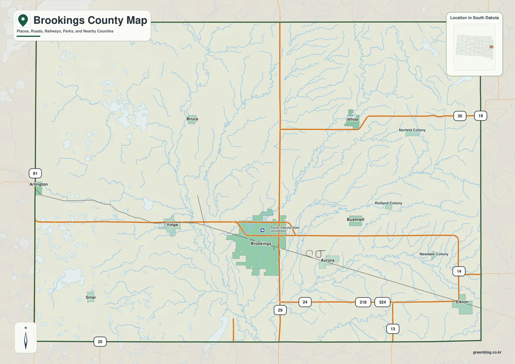
The map is most useful at county scale. It helps answer questions such as which direction Volga lies from Brookings, where I-29 crosses the county, or how far north White and Bruce sit relative to the southern communities. It is not intended to show parcel lines, individual buildings, every rural road, or turn-by-turn directions. For a property boundary, a current road closure, or a detailed local route, the official Brookings County mapping resources are a better source.
The six-city view shows a strong concentration around Brookings
The ranked city map reduces the county to six major communities: Brookings, Volga, Aurora, Elkton, White, and Bruce. Number 1 marks Brookings, followed by Volga, Aurora, Elkton, White, and Bruce. The printed CITY INDEX lists Brookings 23,948, Volga 2,408, Aurora 1,144, Elkton 977, White 484, and Bruce 290. Those figures are treated here only as values printed on the supplied map. The map itself does not establish that they are the latest official population estimates for a particular year, so current demographic figures should be checked separately through the U.S. Census Bureau.
The spatial arrangement is more important than the numbers alone. Brookings and Volga form a close pair in the southern part of the county, with Aurora east of Brookings and Elkton farther southeast near the county edge. White and Bruce sit well to the north of that cluster, one toward the northeast and the other toward the northwest. The numbered markers are ranking symbols rather than distance labels. No straight-line or driving-distance values are printed on this city map, so travel time should be checked with a current road or navigation source.
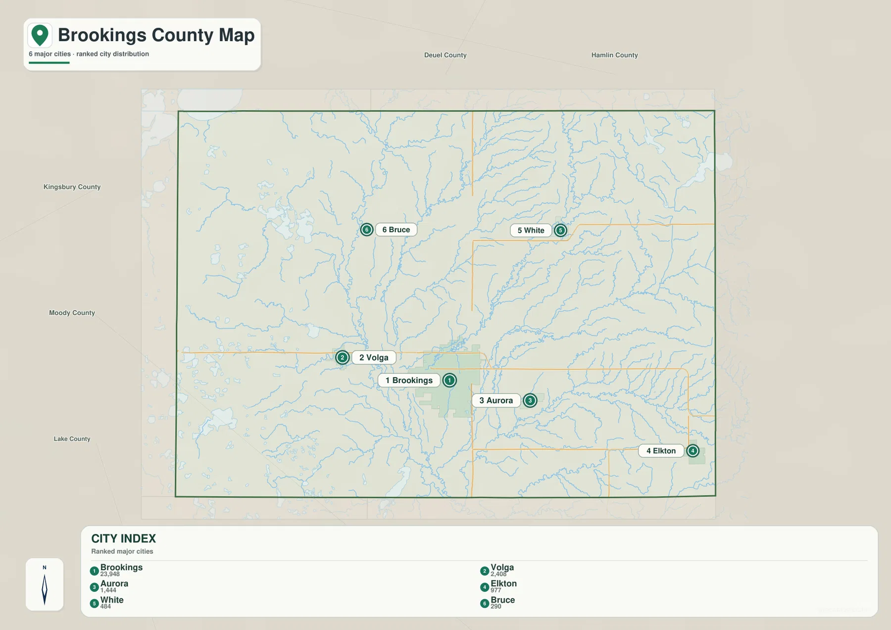
County names outside the boundary provide additional orientation. Deuel County and Hamlin County are labeled to the north, Kingsbury County to the west, and Moody County and Lake County toward the southwest side of the frame. These labels help place Brookings County within eastern South Dakota, but they are not city boundaries. Because the ranked view intentionally omits many smaller place names, readers looking for Bushnell, Sinai, or a colony label should return to the general county map.
Big Sioux River, Lake Poinsett, and the county’s network of lakes and creeks
The water and terrain map changes the emphasis from roads to drainage. The Big Sioux River is the dominant named watercourse, running through the central part of the county and continuing south. Near the northwestern side, Lake Poinsett is the largest labeled lake visible around the county edge. Johnson Lake and Lake Oakwood appear farther south, City Lagoon is labeled west of the central river corridor, Lake Sinai lies in the southwest, and Lake Campbell appears near the southern boundary. Oak Lake stands out in the northeast, away from the main Big Sioux channel.
Several named creeks help explain how the county’s smaller drainage lines connect to the larger river system. North Deer Creek runs toward the central corridor from the west-central area. Sixmile Creek crosses the northeastern and eastern part of the county, while Deer Creek and Medary Creek curve across the east and southeast. Spring Creek is labeled near the southeastern edge. The map also shows many unnamed or lightly labeled tributaries, which makes the county look much more finely divided by water than the road map suggests.
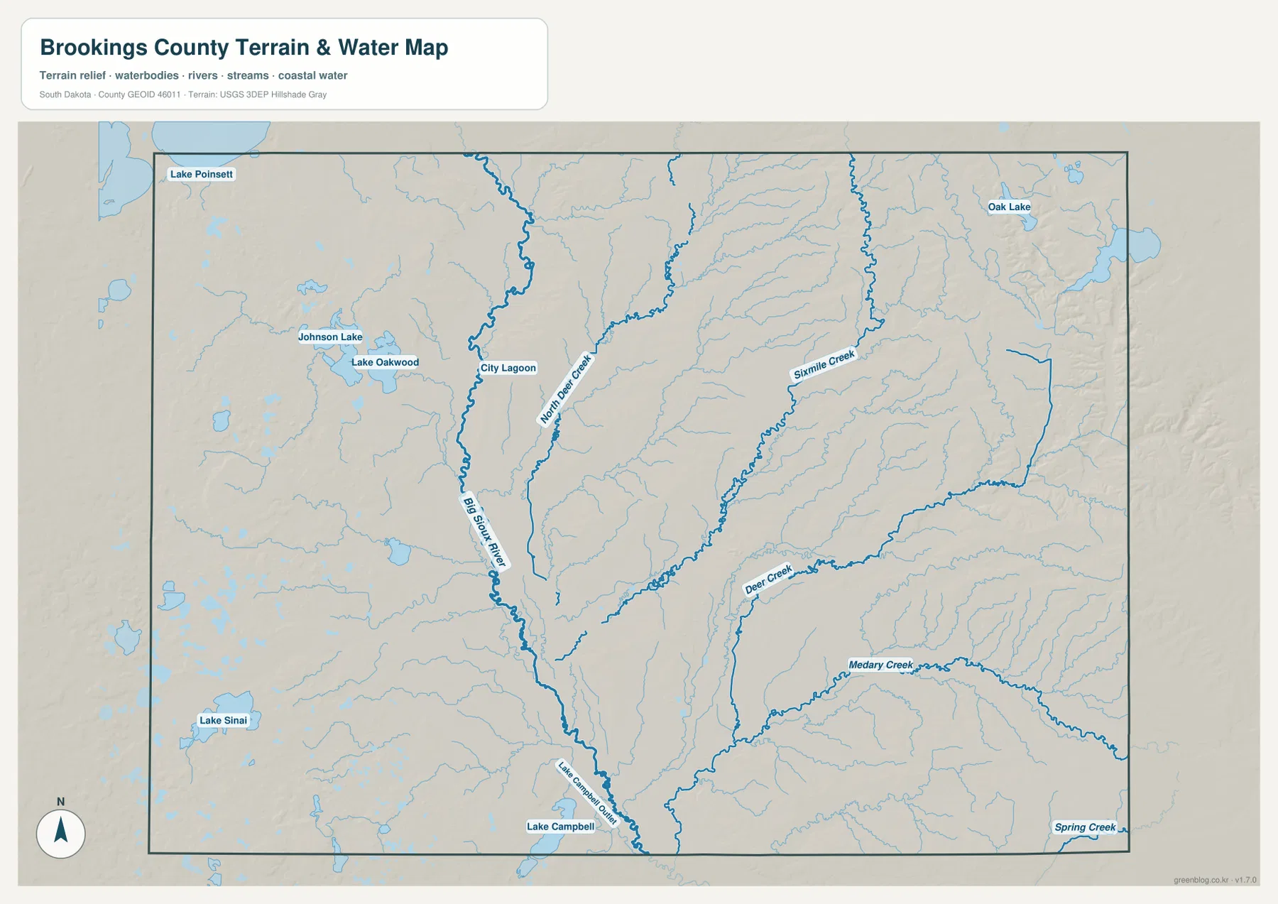
This map is a geographic reference, not a floodplain, navigation, or legal shoreline product. It can help a reader locate Lake Poinsett relative to the Big Sioux River or compare the lakes and creeks on opposite sides of the county, but it does not show flood insurance zones, water depth, real-time stage, parcel ownership, or boating channels. For those questions, use the relevant official county or agency material. Brookings County’s Lake Information page and USGS resources are useful starting points for more specific water information.
A 477–607 m elevation range separates the lower center from higher northeastern ground
The elevation map removes most place and road labels so the shape of the land becomes easier to see. Its legend reports an actual county range of 477 to 607 meters and a mean elevation of 524 meters. A broad green corridor runs through the center from north to south, representing lower ground. This lower band broadly matches the Big Sioux River corridor visible on the water map. The northeastern and eastern parts of the county shift toward yellow, orange, and brown, indicating higher terrain and a more strongly dissected surface.
The western side is not perfectly flat either. Small ridges, shallow valleys, and rolling surfaces appear in the shaded relief, although the strongest continuous high ground is more obvious toward the northeast and east. Comparing the relief with the water map helps explain why so many creeks descend toward the central and southern drainage network. The maps do not need to match feature for feature to be useful; one shows named water bodies, while the other shows the land surface that guides much of that drainage.
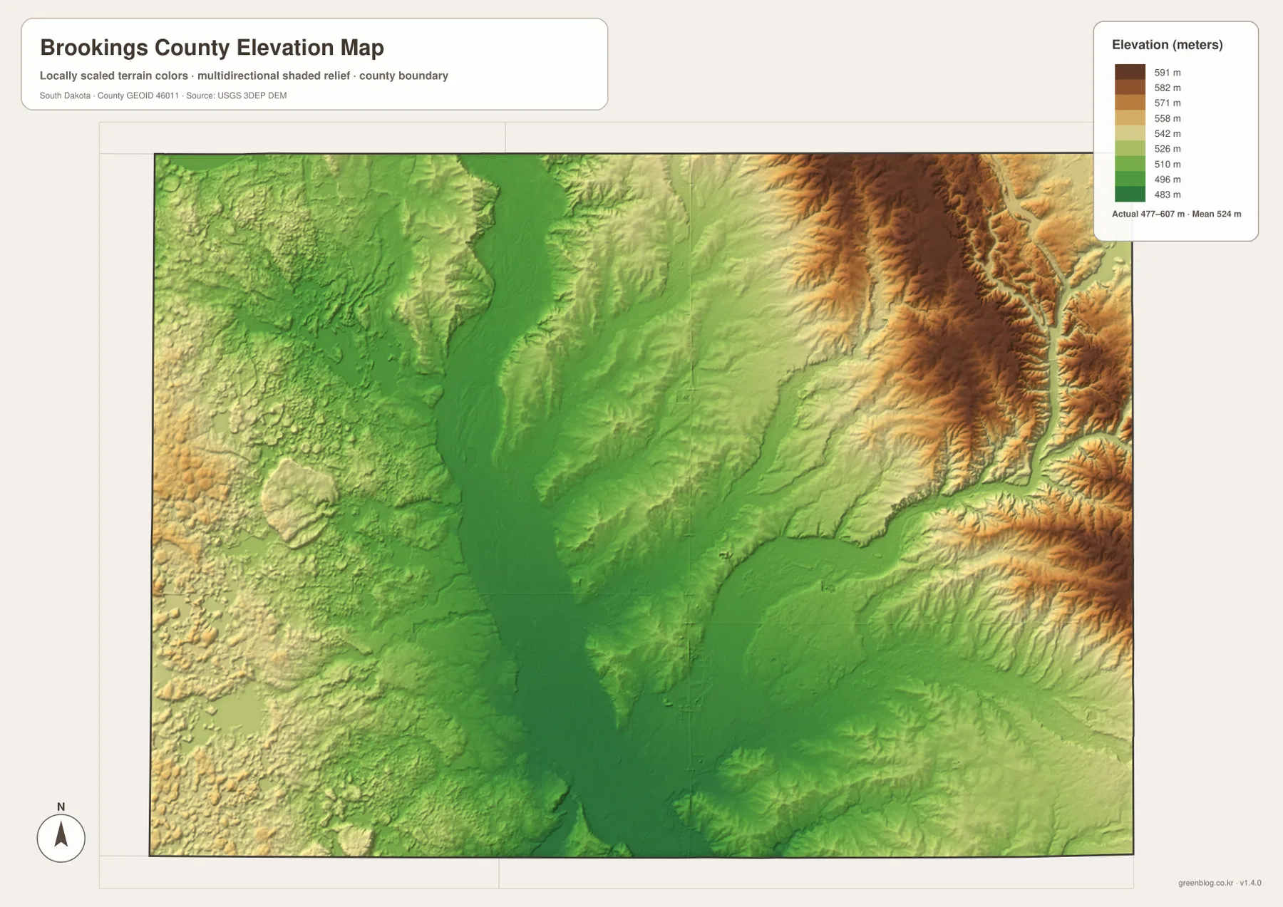
The 477–607 meter range should not be used as a substitute for a precise site elevation. The surface is generalized for county-wide comparison, so it does not provide survey-grade height for a building, field, road crossing, or parcel. For engineering, drainage design, construction, or legal work, use current USGS elevation data or a professional survey. For classroom use, regional comparison, or a quick explanation of why the Big Sioux corridor appears lower than the northeastern terrain, the map is well suited to the task.
Using Brookings and Lake Poinsett as reference points across the maps
One of the clearest ways to compare the files is to follow the same place from one view to another. Start with Brookings. The general map locates the city beside I-29 and along US 14, while the city map shows how strongly it stands out from the other five ranked communities. Move to the water view and the Big Sioux River becomes the stronger reference, with smaller creeks and lagoons filling in the surrounding drainage. On the elevation view, the same central area sits within the county’s lower green corridor rather than the higher northeastern terrain.
Lake Poinsett provides a different comparison. It is prominent near the northwestern edge on the water map, with Lake Oakwood and Johnson Lake farther south. In the shaded relief, the northwest shows a more rolling surface than the broad low central strip. That contrast is useful when a report, class project, or printed handout needs to explain why a lake-and-creek map and an elevation map reveal different parts of the same county landscape.
Choose the general county map when roads, county boundaries, Brookings, Volga, Aurora, Elkton, White, Bruce, or smaller place labels are the main concern. The ranked city view is cleaner when the six major communities are the focus. The water and terrain map works best for the Big Sioux River, Lake Poinsett, Lake Oakwood, Oak Lake, Lake Campbell, and named creeks. The elevation map is the better choice for the 477–607 meter range and the lower-center versus higher-northeast contrast. The page previews are WebP files sized for the web; the download archive contains the corresponding original JPG versions.
Frequently Asked Questions
Does the CITY INDEX value of 23,948 mean Brookings has that population today?
Not necessarily. On this page, 23,948 is treated only as the value printed in the supplied CITY INDEX. The same map lists Volga 2,408, Aurora 1,144, Elkton 977, White 484, and Bruce 290. The map does not provide enough information to verify those figures as the latest official estimates for a specific year. Use U.S. Census Bureau QuickFacts for current population statistics, and use the city map mainly for ranking and location.
Which file is best for comparing the Big Sioux River with Lake Poinsett?
The water and terrain map is the clearest choice because it labels the Big Sioux River, Lake Poinsett, Lake Oakwood, Oak Lake, Lake Campbell, and several named creeks in one view. If you also need Brookings, Volga, I-29, or US 14, compare it with the general county map. The water map does not provide flood zones, water depth, or legal shoreline boundaries, so those questions require the appropriate official resource.
Can I use the 477–607 m elevation map for an exact site height?
No. The map is designed to show county-scale differences in relief. Its 477–607 meter range and 524-meter mean summarize the mapped surface, but they do not identify the exact height of a parcel, structure, or road point. Use USGS source elevation data or a professional survey when precision matters. For general comparison, the map clearly shows the lower central corridor and the higher northeastern and eastern terrain.
Map File Information
Download the Brookings County boundary and roads map, ranked city distribution map, water and terrain map, and elevation map as original high-resolution JPG files.
- Included Files: Use only the versions confirmed in the article and supplied images
- File Type: Use the confirmed download contents
- Intended Use: Printing, education, presentations, and map-based projects
Related Maps
Sources and references
- Brookings County, South Dakota – Official Website
- Brookings County – Maps for Download
- Brookings County – Lake Information
- South Dakota State University – Maps and Directions
- U.S. Census Bureau QuickFacts – Brookings County
- USGS 3D Elevation Program
Green Map creates custom-edited map images using open geographic data sources such as geoBoundaries, Natural Earth, OpenStreetMap, and government open data.
These maps are edited visual materials, not raw data files, and are provided for education, documents, presentations, and graphic reference.