Prince of Wales-Hyder Census Area is one of those Alaska county-equivalents that makes more sense once you see the whole boundary at once. Most of the mapped land is centered on Prince of Wales Island and nearby islands, but the Census Area also includes a northern section around Kake, a detached mainland section at Hyder, and a separate area around Annette Island near Metlakatla. This page explains those pieces together with the island road network, the ranked city locations, and the waterways that divide the region. The same subjects shown in the article are available below as high-resolution A3 JPG files in one downloadable ZIP.
That geography matters because the map cannot be read like a single mainland county crossed by one continuous road system. Craig and Klawock sit close together within the road network on Prince of Wales Island, while Kake, Hyder, and the Annette Island section are separated by water or mainland terrain. Looking first at the complete boundary, then at the city and terrain-and-water maps, helps distinguish places that are close on the page from places that are actually connected by road.
Table of Contents
Start with the detached pieces before following the roads
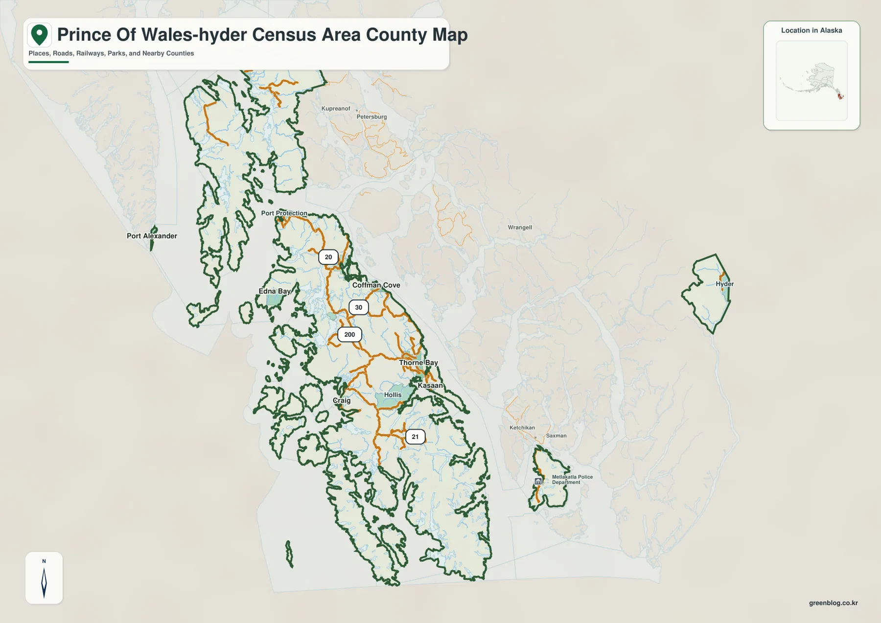
The largest concentration of land and settlements is around Prince of Wales Island. Craig and Klawock appear close together on the southwest side, Hydaburg lies farther south, and Thorne Bay, Kasaan, and Coffman Cove are spread along the eastern half of the island. Hollis is labeled near the southeastern side, while Edna Bay and Port Protection occupy more isolated coastal or island settings. The map is useful precisely because those names are not compressed into one town cluster; their relationship to shorelines and islands remains visible.
Hyder is the easiest piece to miss if the map is cropped too tightly. It appears on the far eastern side as a detached mainland polygon, well away from the Prince of Wales Island road network. A separate boundary is also visible around Annette Island near Metlakatla to the southeast. For a classroom graphic, report, or regional reference, keeping those detached pieces in view prevents the Census Area from being mistaken for only the Prince of Wales Island group.
Labels outside the boundary provide additional Southeast Alaska context. Petersburg, Wrangell, Ketchikan, Saxman, and other nearby places help show where the Census Area sits among neighboring county-equivalents and communities. The boundary line on this page is a geographic reference rather than a parcel or survey product. When a project requires authoritative current boundaries, U.S. Census Bureau TIGER/Line geography should be checked directly.
Craig and Klawock anchor the Prince of Wales Island road network
Roads are unusually prominent on the Prince of Wales Island portion of the general map. Several lines meet around Craig and Klawock, then extend toward Thorne Bay and Kasaan on the east side, Coffman Cove farther north, and Hydaburg and Hollis toward the south and southeast. Alaska DOT&PF describes the island road system separately, which fits what the map shows: multiple communities on the main island can be understood through a connected road network rather than only through marine routes.
The supplied map prints route numbers such as 20, 30, 200, and 21 along parts of that network. They are useful for tracing the lines on this particular image, but this article does not assume that every printed number should be treated as a current statewide highway designation without checking the transportation source. Anyone planning an actual drive should use current Alaska DOT&PF road information, especially when seasonal conditions, maintenance, or local road status could affect travel.
The road pattern also highlights the limits of road-based interpretation. Kake is north of the main Prince of Wales Island cluster, Hyder is on the detached mainland section, and Metlakatla is on Annette Island. A road line visible on Prince of Wales Island does not mean the entire Census Area can be crossed by car. Ferry, air, marine, and local transportation information may be necessary whenever a trip crosses from one of the separated sections to another.
The city index puts Kake apart from the Prince of Wales Island cluster
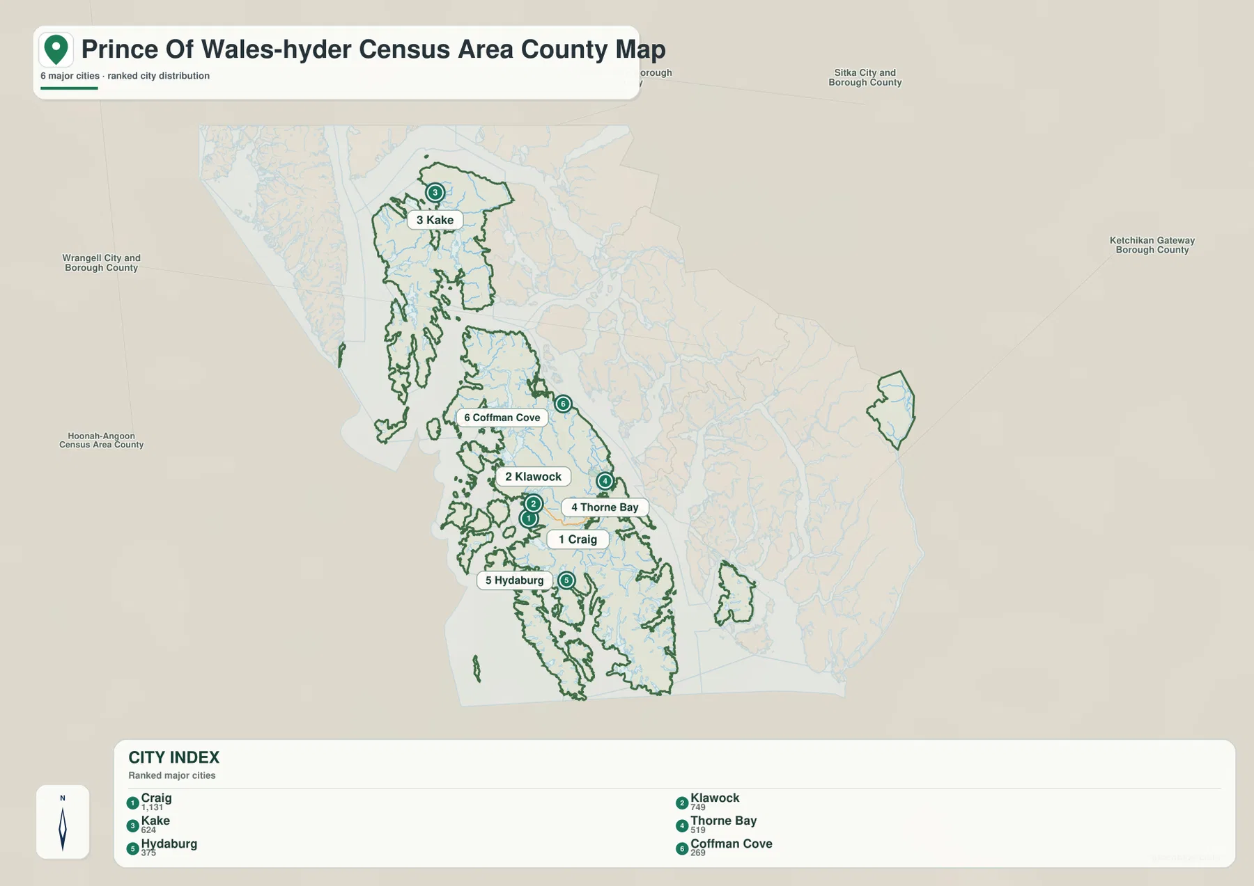
The ranked city map removes much of the background detail so that six highlighted cities can be compared quickly. Its printed index lists Craig at 1,131, Klawock at 749, Kake at 624, Thorne Bay at 519, Hydaburg at 375, and Coffman Cove at 269. Those values are the numbers printed on the supplied map; they are best treated as part of this map’s city index rather than as a replacement for a current Census Bureau population table.
Craig and Klawock form the clearest geographic pair. Their markers sit close together on the southwest side of Prince of Wales Island, while Thorne Bay lies to the east, Hydaburg farther south, and Coffman Cove well to the north along the island. Kake is the major positional outlier. It appears far north of the other five ranked cities, making the separation between the main-island group and the northern section immediately obvious.
The six-city index is selective, not exhaustive. The general map also labels Kasaan, Hollis, Edna Bay, Port Protection, Hyder, Metlakatla, and other communities. Their absence from the ranked version does not place them outside the Census Area. Use the city map when those six highlighted cities are the subject, and return to the full boundary map when the goal is to show the wider settlement pattern or explain detached Hyder and Annette Island.
Waterways divide the region as strongly as roads connect the main island
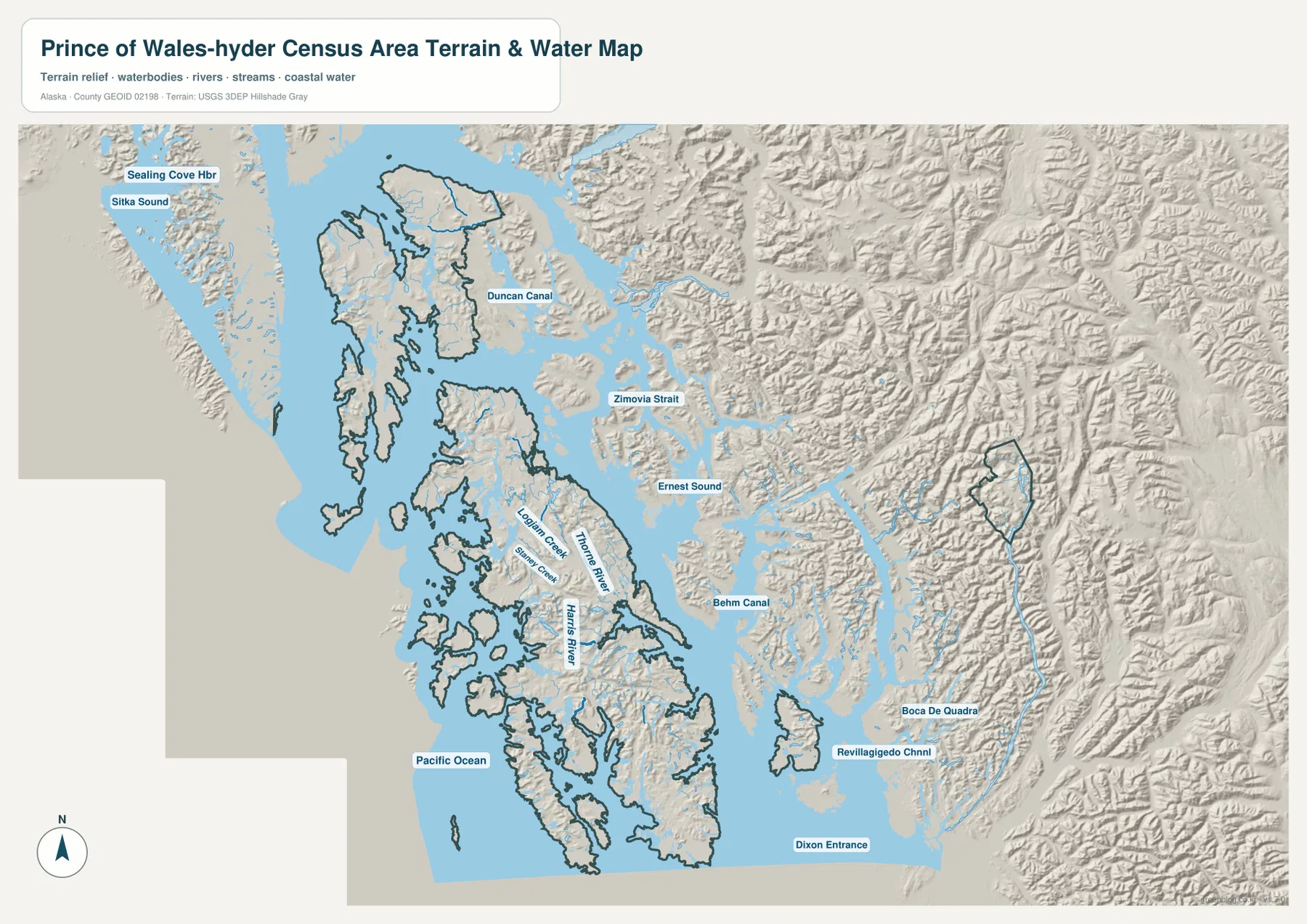
The terrain-and-water map explains the broken shape of the Census Area better than the boundary alone. Duncan Canal lies north of the central island group, with Zimovia Strait and Ernest Sound to the east. Farther south, Behm Canal separates island and mainland terrain, while Revillagigedo Channel and Dixon Entrance open toward broader coastal waters. The Pacific Ocean is labeled to the west. These channels are not decorative background; they are the water spaces that separate many of the land sections and communities seen on the other maps.
Freshwater features give Prince of Wales Island another layer of detail. Thorne River crosses the east-central part of the island, Harris River is labeled farther south, and Logjam Creek and Staney Creek appear in the central-western interior. Alaska Department of Fish and Game describes numerous streams and lakes on the island, with many areas accessible from the road system. Putting the roads and waterways side by side shows how settlements on the coast relate to interior valleys, rivers, and forested terrain.
Shaded relief also makes the detached mainland areas easier to distinguish. Prince of Wales Island has ridges and hilly terrain, but the Hyder section is surrounded by especially rugged mountains and narrow valleys close to the coast. The mainland east of Behm Canal and around Boca de Quadra appears similarly steep. The relief is useful for comparing broad terrain, not for reading exact elevations. Projects that depend on precise height measurements should use USGS 3D Elevation Program data or another dedicated elevation source.
This map is not a nautical chart, flood-hazard map, or engineering survey. It does not provide water depth, tides, reefs, navigation marks, flood probability, evacuation zones, or survey-grade elevations. Use it to understand where channels, rivers, islands, and mountain terrain are located relative to one another. Navigation, hazard analysis, and infrastructure decisions require current purpose-specific information from the appropriate federal, state, or local agencies.
Choose the map by what you need to show
For administrative orientation, the general map is the strongest starting point because it keeps Prince of Wales Island, the Kake section, detached Hyder, and the Annette Island area in the same frame. It also shows more community labels and the road network, so it works well for a regional overview or a report that needs to explain why the Census Area is not one continuous piece of land.
Use the ranked city map when Craig, Klawock, Kake, Thorne Bay, Hydaburg, and Coffman Cove are the main comparison. Use the terrain-and-water version when channels, rivers, and relief are more important than city rank. Duncan Canal, Ernest Sound, Behm Canal, Dixon Entrance, Thorne River, and Harris River are much easier to locate there. Combining two maps can be useful when a presentation needs both settlement locations and the physical reasons those settlements are separated.
The WebP images in the article are optimized for on-page viewing. For printing, close label inspection, classroom handouts, or presentation graphics, the download contains three A3 high-resolution JPG files at 3638 by 2572 pixels: the general boundary-and-road map, the ranked city map, and the terrain-and-water map. They are convenient reference graphics, but they should not replace official survey, navigation, boundary, transportation, or hazard datasets when accuracy for a technical decision is required.
Frequently Asked Questions
Why is Hyder shown far away from the main Prince of Wales Island section?
The supplied boundary map shows Hyder as a detached mainland section on the eastern side of the Census Area. Prince of Wales-Hyder is not one continuous piece of land, so a complete regional map needs to keep that Hyder polygon visible even though it is far from the main island road network.
Are the numbers in the six-city index current population figures?
The numbers are the values printed on the supplied ranked city map and are used here as part of that map’s comparison. For current population statistics or formal demographic analysis, check the latest U.S. Census Bureau profile or QuickFacts data rather than relying on the static graphic alone.
Can I drive from the Prince of Wales Island road network to Kake or Hyder?
Not by treating the mapped road lines as one continuous Census Area road system. Kake is in a separate northern island section and Hyder is on the detached mainland section. Actual travel may require ferry, air, marine, or other local transportation, so current transportation information should be checked before planning a trip.Map File InformationThe archive contains the Prince of Wales-Hyder Census Area boundary-and-road map, ranked city map, and terrain-and-water map as high-resolution A3 JPG files.
Map File Information
Download the map files associated with this page for reference, printing, and compatible visual projects.
- Included Files: Use only the versions confirmed in the article and supplied images
- File Type: Use the confirmed download contents
- Intended Use: Printing, education, presentations, and map-based projects
Related Maps
Sources and references
- U.S. Census Bureau – Prince of Wales-Hyder Census Area Profile: official geographic and demographic profile
- U.S. Census Bureau QuickFacts: current summary statistics
- Alaska DOT&PF – Prince of Wales Island Road System: official road-system background for Prince of Wales Island
- Alaska Department of Fish and Game – Prince of Wales Management Area: streams, lakes, access, and regional environment
- USGS National Hydrography: official hydrography reference for rivers, streams, and water features
Green Map creates custom-edited map images using open geographic data sources such as geoBoundaries, Natural Earth, OpenStreetMap, and government open data.
These maps are edited visual materials, not raw data files, and are provided for education, documents, presentations, and graphic reference.