Denali Borough covers a very large part of interior Alaska, but the supplied maps make its internal pattern surprisingly clear. Anderson, Ferry, Healy, Denali Park, and Cantwell form a recognizable sequence along the eastern side of the borough, while the western and southwestern portions contain far fewer settlement labels and many more streams, lakes, and rugged landforms. The general borough map is best for boundaries, places, and roads. The city index map isolates Anderson as the one ranked city in the package. The terrain and water map adds Toklat River, Bearpaw River, Wonder Lake, Chilchukabena Lake, Otto Lake, and many smaller water features. High-resolution JPG versions of these same three map products are available in the ZIP download box below.
The official Denali Borough website describes the borough as a gateway to Denali National Park between Anchorage and Fairbanks, spanning more than 12,000 square miles. It identifies Anderson, Healy, McKinley Village, Cantwell, and smaller settlements as important communities and notes the importance of the George Parks Highway and Alaska Railroad. That official description matches the broad visual pattern in the supplied maps: populated places are concentrated along a relatively narrow eastern corridor, while a much larger western interior is dominated by natural terrain and drainage. Reading the maps in that order—settlements first, then waterways and relief—makes the borough easier to understand without treating the sparsely labeled west as empty space.
Table of Contents
A long settlement corridor runs down the borough’s eastern side
On the general map, Anderson sits close to the northern boundary. Ferry and Healy appear farther south, followed by Denali Park and then Cantwell near the southeastern part of the borough. These labels do not form a dense urban cluster; instead, they create a long north-south sequence that gives the reader a practical frame of reference. Nenana and Four Mile Road appear beyond the borough to the north, while Lake Minchumina is labeled outside the western side. Those surrounding names help orient the map, but the dark green borough boundary remains the key line for deciding what is inside the mapped county-equivalent area.
The borough’s own community information explains that its main communities are associated with the George Parks Highway and the Alaska Railroad. The supplied borough map also shows a strong road corridor through Anderson, Ferry, Healy, Denali Park, and Cantwell. Route 8 is labeled near Cantwell, making the southern part of the settlement corridor especially easy to identify. This map is useful for regional orientation, not for current driving conditions. It does not show temporary closures, construction, winter hazards, or live road status, so travelers should use current transportation sources when planning an actual trip.
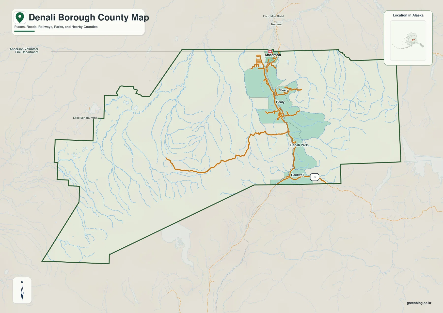
The boundary itself helps explain why the borough feels so different from a compact county. Long straight segments appear across parts of the north and east, while the western edge steps through several turns and the southwestern portion extends well beyond the main settlement labels. Streams are much more numerous across the western half than place names. This creates a strong visual contrast between the transportation-and-community corridor in the east and the large natural interior to the west. Looking at those two halves together is more informative than reading the road network or the boundary alone.
Why the city index contains only Anderson
The city index map uses a narrower classification than the general map. Its CITY INDEX ranks only Anderson and prints the value 140 beside it. That number is part of the supplied map graphic, so it is presented here as map content rather than replaced with a separate current population estimate. The omission of Healy, Cantwell, Ferry, and Denali Park from this index does not mean those places are unimportant or missing from the borough. The official Denali Borough About page identifies Anderson as the borough’s only incorporated city, while other well-known places are described as communities or settlements with different legal classifications.
This distinction is useful when comparing the two maps. The general map answers a broad location question: where are the principal named places and how are they arranged within the borough? The city index answers a more specific classification question by ranking the incorporated city represented in the package. Healy remains a major reference point on the general map and in borough materials even though it is not ranked in the city panel. Readers therefore should not use the city index as a complete list of populated places. It is a focused city layer, not a substitute for the settlement labels on the general borough map.
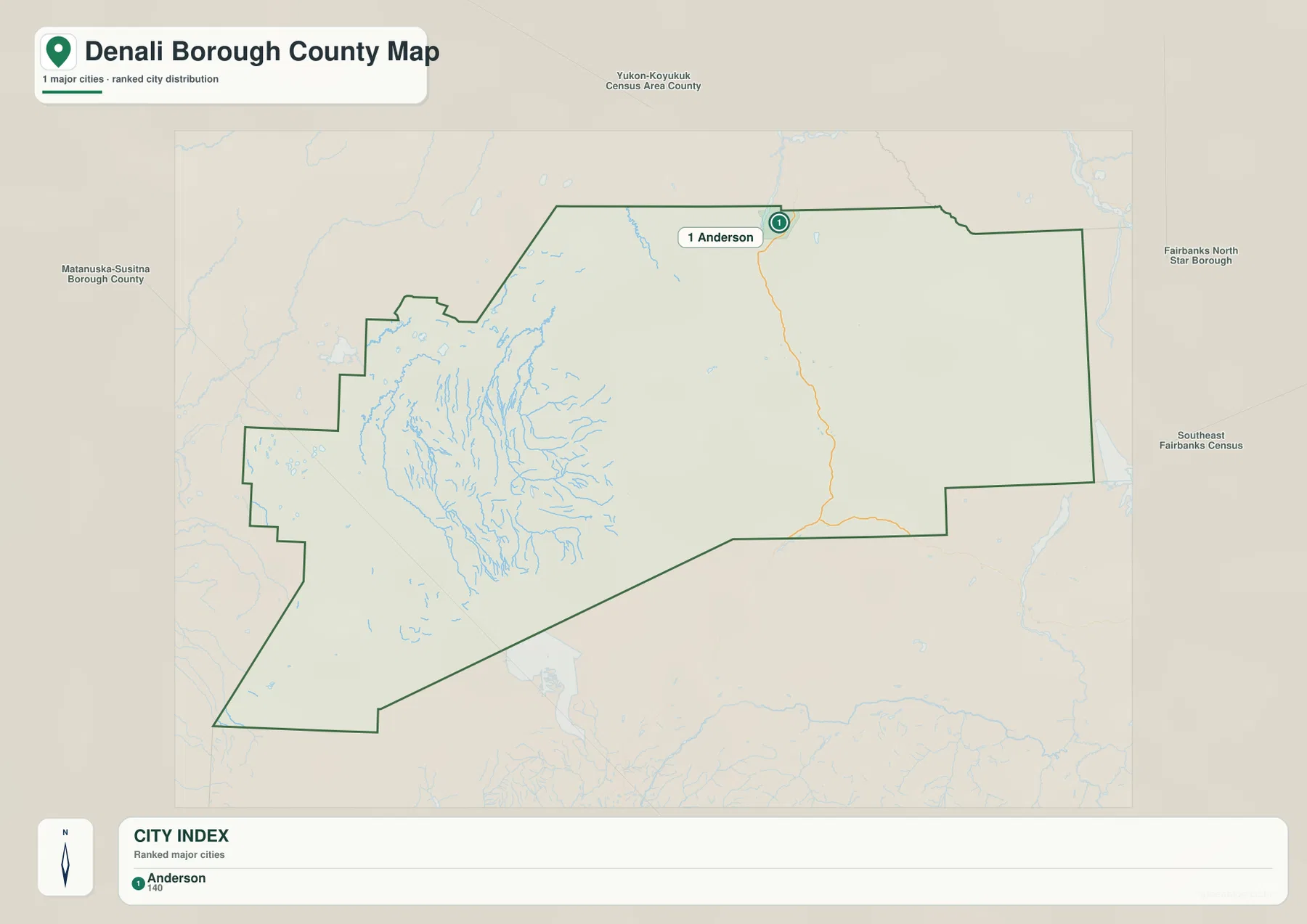
The surrounding administrative labels provide another useful clue. Matanuska-Susitna Borough is shown to the west, Yukon-Koyukuk Census Area to the north, and Fairbanks North Star Borough and Southeast Fairbanks Census Area to the east. These labels help place Denali Borough within interior Alaska without crowding the map with additional local detail. They should not be treated as survey-grade boundary evidence. If an exact jurisdictional line is required, the U.S. Census Bureau’s TIGER/Line products are the appropriate next step.
Toklat River and a chain of named lakes define the western interior
The terrain and water map shifts attention away from settlements and toward the borough’s drainage. Toklat River is labeled in the north-central part of the map, and Bearpaw River runs farther south and west. Bear Creek and Birch Creek are also named, along with many thinner stream lines that spread through the western interior. The National Park Service describes the Toklat as a major braided river crossed by the Denali Park Road and notes that it flows out of the Alaska Range. The supplied map is not intended to show channel depth or flow conditions, but it gives readers a strong regional reference for locating the river within the borough’s broader mountain landscape.
The lake labels add another layer of detail. Chilchukabena Lake, Carlson Lake, Spectacle Lake, Big Lake, Burnt Lake, and Castle Rocks Lake appear across the west and northwest. Wonder Lake is labeled farther toward the central-western mountains. 7 Mile Lake appears near the north, while Eightmile Lake and Otto Lake are shown farther east. Because these lakes are scattered rather than grouped in one basin, they work well as location anchors when the western half of the borough otherwise has few settlement names. A reader can move from Toklat River to Bearpaw River, then to Wonder Lake and the surrounding smaller lakes, building a clearer mental picture of the interior.
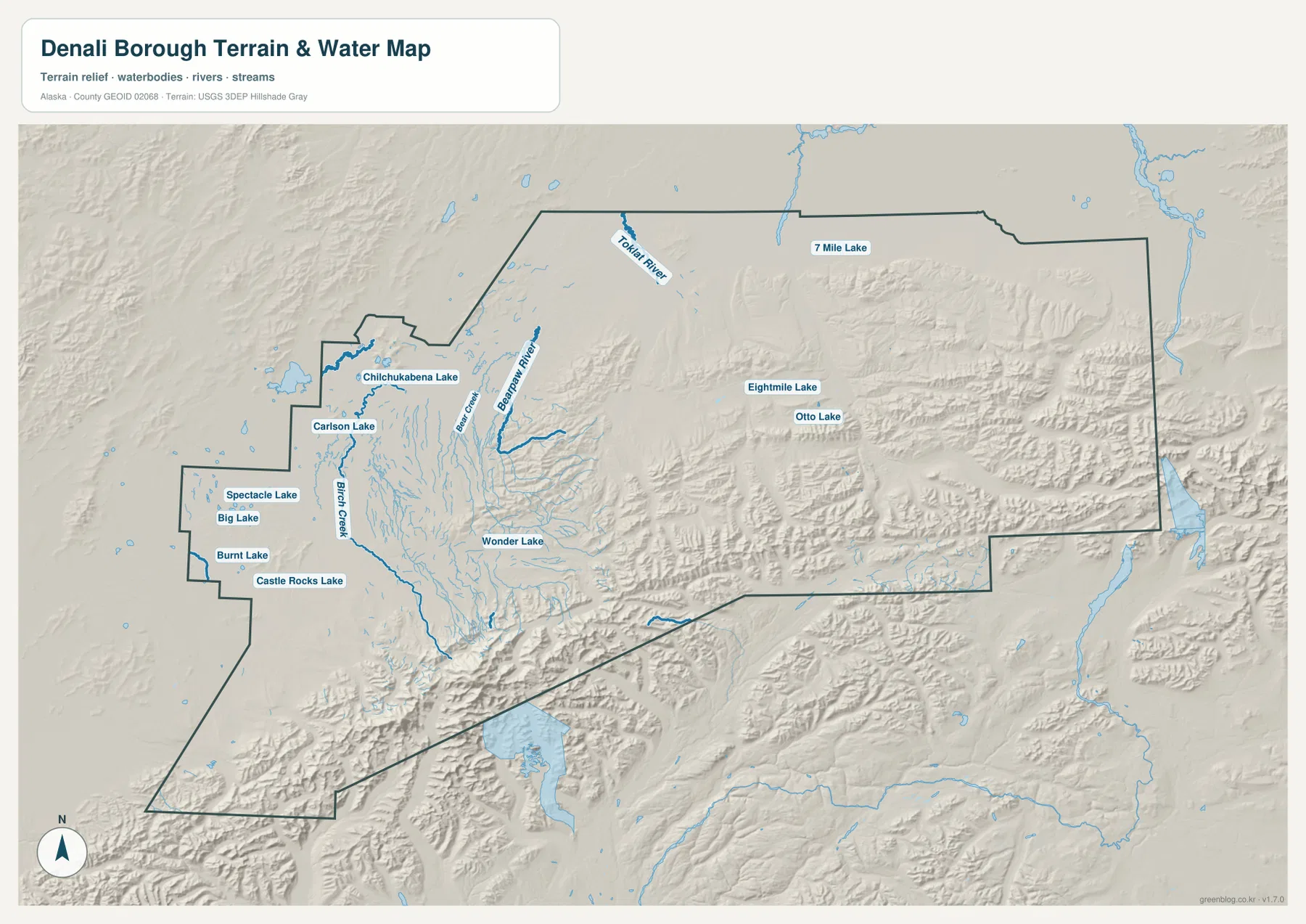
The shaded relief shows pronounced mountain terrain along much of the south and in parts of the central and eastern borough. Other areas look broader and smoother, producing a visible change in terrain across the map. The shading is valuable for understanding where ridges and valleys are concentrated, but it does not provide survey elevations or engineering-grade slope measurements. Anyone who needs numerical elevation data should consult a dedicated source such as the USGS 3D Elevation Program rather than estimating heights from the relief image.
The water layer also has clear limits. It is not a flood map, a navigation chart, a real-time river gauge, or a water-rights document. It is best used to identify named rivers, creeks, and lakes and to see how they sit within the borough’s terrain. For detailed hydrographic data, the USGS National Hydrography resources provide a more appropriate authoritative source. Using the visual map for orientation and the official dataset for precise analysis keeps those two purposes separate.
Mountain relief explains the contrast between the road corridor and the open interior
Putting the three maps together reveals the borough’s strongest geographic contrast. Anderson, Ferry, Healy, Denali Park, and Cantwell are aligned along the eastern side, where the major transportation corridor is easiest to follow. West of that sequence, the map opens into a much larger area with lakes, rivers, and mountain relief but few ranked settlement symbols. This is why a road-centered reading of Denali Borough can be misleading: the populated corridor occupies only part of the mapped area, while the natural landscape extends far beyond it.
The Denali Park label gives readers another important anchor. National Park Service material describes Denali National Park and Preserve as a vast protected landscape with a single main park road and extensive river valleys and mountain terrain. The borough map in this package is not a park visitor map and does not attempt to show every park boundary, trail, campground, or visitor facility. Its purpose is broader: it shows where Denali Park sits in relation to Healy, Cantwell, Anderson, the borough boundary, and the surrounding drainage. For recreation details inside the national park, the NPS map and current visitor information should be used instead.
A simple three-step reading method works well. First, find Anderson near the north and trace the settlement corridor south through Ferry and Healy to Denali Park and Cantwell. Second, move west on the terrain and water map to locate Wonder Lake, Toklat River, Bearpaw River, and the cluster of smaller lakes. Third, compare the shaded relief in the south and east with the broader areas elsewhere. This sequence turns a large, sparsely labeled borough into a set of recognizable geographic zones rather than a collection of disconnected names.
Choose the map by question, then download the high-resolution JPG files
Each supplied map is strongest for a different task. The general borough map works best for the boundary, principal settlement labels, roads, and the overall relationship between Anderson, Healy, Denali Park, and Cantwell. For the ranked city layer, the city index isolates Anderson and places the borough among its neighboring administrative areas. Rivers, lakes, and mountain relief are much clearer on the terrain and water map. Switching maps according to the question is faster and clearer than trying to extract every detail from one crowded image.
- Boundary and settlement orientation: start with the general map and locate Anderson, Ferry, Healy, Denali Park, and Cantwell.
- City classification: use the city index to see Anderson as the single ranked city in the supplied panel.
- Rivers, lakes, and terrain: use the terrain and water map for Toklat River, Bearpaw River, Wonder Lake, Chilchukabena Lake, Otto Lake, and shaded relief.
- Precise official data: move from these visual maps to Census or USGS datasets when exact boundaries, hydrography, or elevation values are required.
For a classroom or presentation, a useful sequence is to introduce the borough with the general map, explain the city-versus-community distinction with the city index, and then finish with the terrain and water map to show how much of the borough is shaped by rivers, lakes, and mountains. The downloadable archive contains the same three map subjects as larger JPG images, which is helpful when a screen-resolution WebP is not sufficient. Legal boundary work, surveying, current road conditions, and hazard decisions still require the latest authoritative sources.
Frequently Asked Questions
Why are Healy and Cantwell on the general map but not in the city index?
The two maps use different selection rules. The general map labels important communities and places across the borough, while the city index ranks the incorporated city represented in the package. The Denali Borough government identifies Anderson as the borough’s only incorporated city. Healy and Cantwell remain important community reference points and are clearly shown on the general map, but they are not treated as ranked cities in the city panel.
Which map is best for finding Toklat River and Wonder Lake?
Use the terrain and water map. Toklat River is labeled in the north-central area, while Wonder Lake appears farther west among the mountain and lake features. The same map also labels Bearpaw River, Chilchukabena Lake, 7 Mile Lake, Eightmile Lake, Otto Lake, and several smaller water features, making it the most useful of the three for hydrographic orientation.
What is included in the downloadable ZIP?
The ZIP contains three high-resolution JPG images matching the subjects shown in the article: the general Denali Borough map, the city index map, and the terrain and water map. It does not include a separate elevation-only map, live road information, or a flood-risk product. The larger JPG files are intended for printing, teaching, presentations, and offline geographic reference.
Map File Information
The original Denali Borough map images shown in this article are available as high-resolution JPG files. The ZIP is intended for readers who need larger images for printing, lessons, presentations, or offline geographic reference.
- Included Files: 3 high-resolution JPG images
- File Type: JPG files in one ZIP archive
Related Maps
Sources and references
This article is based primarily on the supplied Denali Borough map graphics: their boundary, place labels, city index, roads, named rivers and lakes, and shaded terrain. The official sources below provide additional context for borough communities, Denali waterways, administrative boundaries, hydrography, and elevation data.
- Denali Borough – About
- National Park Service – Rivers and Streams of Denali
- U.S. Census Bureau TIGER/Line Shapefiles
- USGS National Hydrography
- USGS 3D Elevation Program
Green Map creates custom-edited map images using open geographic data sources such as geoBoundaries, Natural Earth, OpenStreetMap, and government open data.
These maps are edited visual materials, not raw data files, and are provided for education, documents, presentations, and graphic reference.