A Gambia Map has an immediately recognizable shape: a narrow strip of West African territory following the lower Gambia River from the Atlantic coast toward the interior. Except for its western coastline, the country is bordered by Senegal, so the national outline looks almost enclosed within its larger neighbor. A written list does not easily show how Banjul, Kanifing, Brikama, Kerewan, Mansakonko, Kuntaur, Janjanbureh, and Basse relate to the river, coast, and one another.
This resource provides three views of the same administrative layout: a color map, an unlabeled outline, and a labeled black-and-white map. Each image measures 1200 × 559 pixels and uses the WEBP format. The landscape frame preserves the country’s east–west form, while the surrounding space identifies Senegal and the North Atlantic Ocean. The three-map set supports geography lessons, reports, slides, labeling exercises, and regional comparisons.
The country covers about 11,300 square kilometers and recorded 2,422,712 residents in the preliminary results of the 2024 Population and Housing Census. Banjul is the capital at the river mouth, but the larger urban concentration extends into Kanifing and western Brikama. Farther inland, administrative centers continue along both sides of the river. This compact coastal zone and long inland corridor provide the key to reading the maps.
Table of Contents
Reading the Gambia Map Along the River Corridor
The Gambia River explains the national form. The territory follows both banks of the lower river, widening and narrowing inland. Near the Atlantic, the estuary and tidal channels create a complicated western edge; eastward, the border continues in an elongated band to the rounded end around Basse.
On the Gambia Map, northern and southern administrative areas interlock around this winding corridor. Kerewan occupies much of the northwest, while Brikama and Mansakonko extend across sections to the south. Kuntaur and Janjanbureh divide the central river zone, and Basse forms the eastern end. Curved riverbanks and irregular boundaries create narrow connections and bends rather than a simple row of regions.
Senegal lies north, east, and south of The Gambia, while the North Atlantic Ocean defines the short western side. Banjul sits close to the river mouth rather than near the country’s geographic center, making the surrounding context important for orientation.
Eight Local Government Areas from Coast to Interior
The supplied maps distinguish eight local government areas: Banjul, Kanifing, Brikama, Mansakonko, Kerewan, Kuntaur, Janjanbureh, and Basse. Banjul and Kanifing are small western urban jurisdictions, whereas several inland areas occupy much longer stretches along the river corridor.
Brikama covers a broad western area south of the river, Kerewan lies mainly across the north bank, and Mansakonko is positioned farther east on the south side. Kuntaur and Janjanbureh divide the central portion, while Basse anchors the eastern end. A Gambia Map reveals both scale and direction: the compact capital area, wider western hinterland, central bends, and eastern terminus fit on one page.
The labels use local government area names rather than every district or settlement. This keeps the national structure readable at a 1200-pixel width and suits an overview lesson better than street navigation or detailed local planning.
Three Map Versions and What Each One Shows
The files share one outer form and internal boundary framework, but serve different roles. Color emphasizes regional comparison, the outline leaves space for annotations, and monochrome retains names with less visual competition. Together, they make the Gambia Map collection flexible without implying that roads, terrain, population density, or tourist sites are shown.
Color-Coded Administrative View
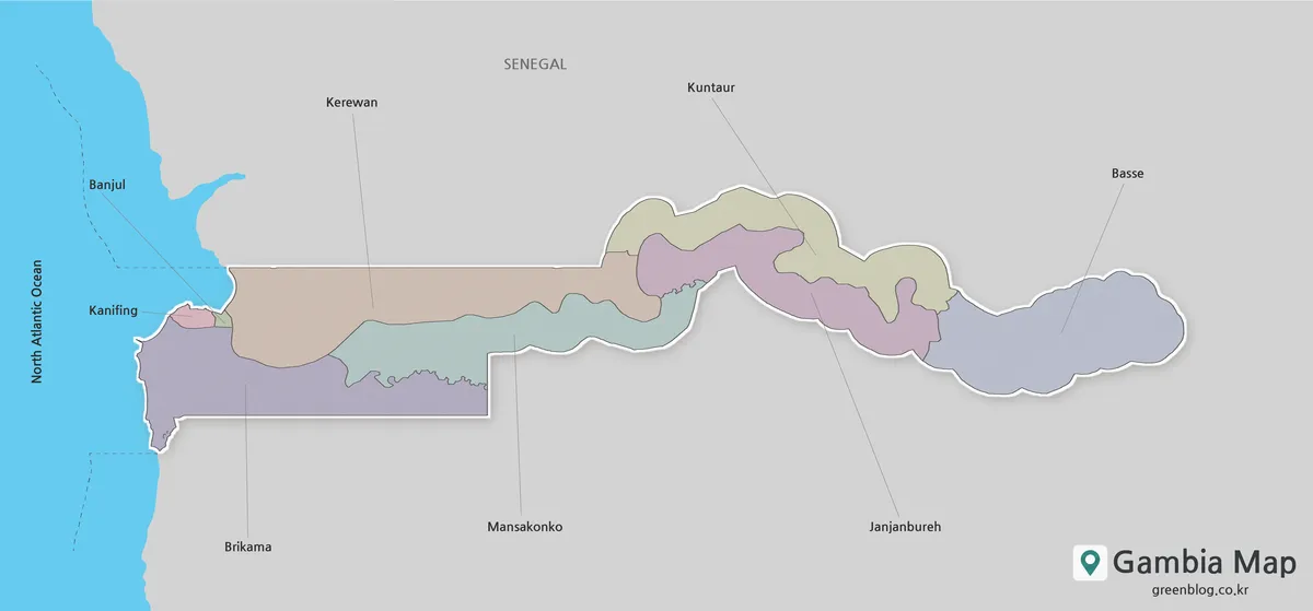
Pastel colors separate the eight areas while keeping Senegal neutral. This makes small Banjul and Kanifing easier to distinguish from Brikama and the larger inland regions. Leader lines connect names to narrow or irregular areas, while the blue Atlantic edge provides a western reference.
The color Gambia Map is the clearest choice for quick comparison. A teacher can explain the shift from coastal urban jurisdictions to the river-based interior, while a presentation designer can pair the fills with regional statistics in a separate chart. The existing color separation requires few added symbols.
Unlabeled Outline for Annotation
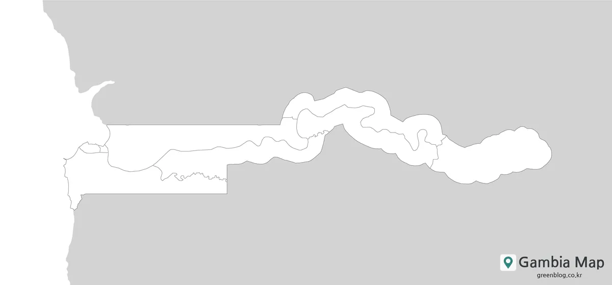
The outline removes place names, leader lines, and fills while preserving the national edge and internal divisions. Readers can add the capital, mark the river corridor, number the eight areas, or build an identification exercise. Students might color the north and south banks differently, while an infographic can carry a limited set of custom categories.
This is a raster annotation base, not a vector source file. Extensive enlargement may soften its thin lines, so worksheets and digital documents should retain the original proportions and recognizable long form.
Labeled Black-and-White Reference
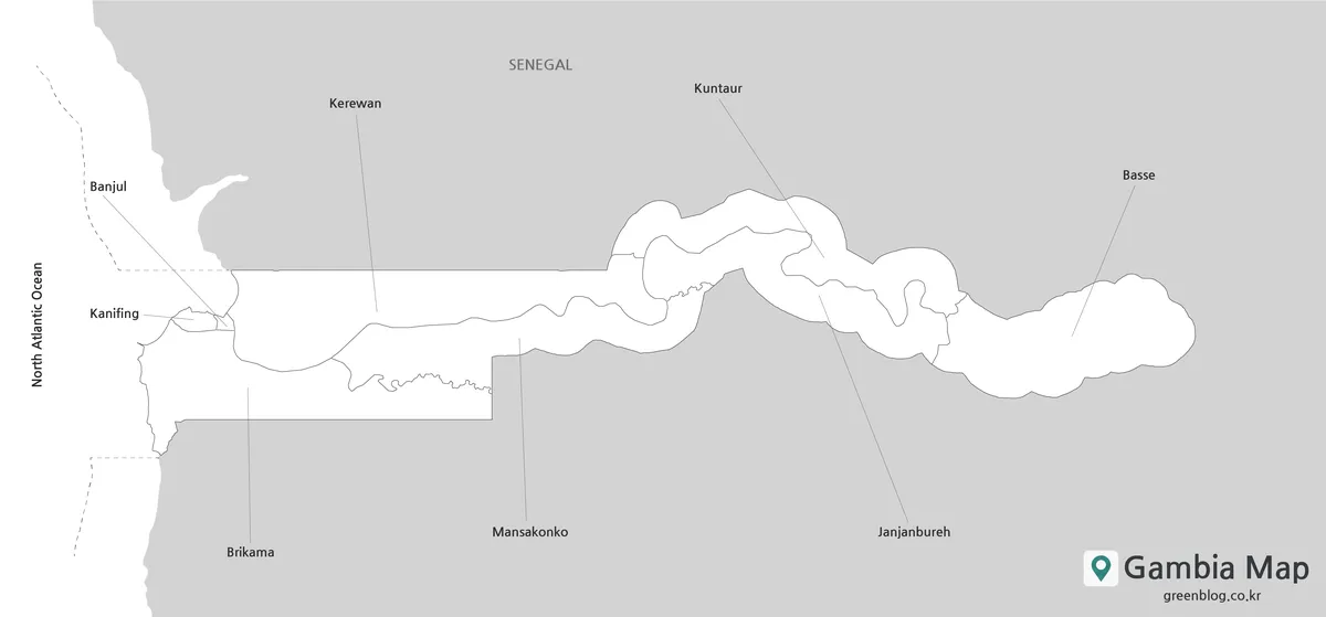
The black-and-white file keeps Senegal, the North Atlantic Ocean, and all eight names visible but removes regional fills. Fine leader lines remain important around small Banjul and Kanifing and the curved central section near Kuntaur and Janjanbureh. Names and boundaries carry the visual information.
This Gambia Map version fits reports, monochrome handouts, and restricted-color documents. It can serve as an answer reference beside the outline. Preserve landscape orientation and avoid reducing it until the thin western connectors disappear.
Choosing a Version for a Specific Task
Choose color when regional separation must be understood at a glance, especially on slides. Use the outline when readers will supply labels, colors, routes, or statistical categories. Select monochrome when names must remain visible but color is unnecessary.
The files can form a coordinated sequence: introduce the color map, test recognition with the outline, and finish with the monochrome reference. In a report, the outline can carry annotations while the color Gambia Map provides the geographic key.
Practical Uses and Layout Considerations
The wide aspect ratio suits a landscape page, full-width article section, or presentation slide better than a narrow portrait column. On a portrait worksheet, place the image across the page rather than cropping Banjul or Basse from opposite ends.
Classroom tasks can cover capital location, area identification, the Senegal border, and coastal-to-inland comparisons. Bloggers can explain why The Gambia is almost surrounded by Senegal, while presenters can pair a Gambia Map with statistics kept outside the image. Roads and travel routes require a separate current source.
External labels prevent the western coast from becoming crowded. Leader lines preserve names without covering small jurisdictions, and open surrounding space keeps the irregular river-shaped edges visible.
Frequently Asked Questions
What administrative areas are shown on the maps?
The maps show Banjul, Kanifing, Brikama, Mansakonko, Kerewan, Kuntaur, Janjanbureh, and Basse. They present the eight local government areas as a national overview. Smaller districts, roads, villages, terrain, and tourist attractions are not included in this particular collection.
Which Gambia Map should I use for a classroom worksheet?
Use the unlabeled outline when students need to identify, color, or number the areas themselves. The color version can introduce the layout before the activity, and the black-and-white labeled version can serve as a reference or answer sheet without changing the underlying boundaries.
Do the files show the Gambia River as a separate blue layer?
The maps are organized around the country’s river-shaped territory, but they are administrative reference images rather than dedicated hydrographic maps. The Atlantic Ocean is colored blue in the color version. Readers preparing a river lesson can mark or label the river corridor on the blank outline.
What size and format are the supplied images?
All three body images measure 1200 × 559 pixels and are supplied in WEBP format. They share a landscape proportion suited to the country’s long shape. No A3 layout, PDF, SVG, transparent background, or editable source file has been confirmed for this set.
Can these maps be used for travel navigation?
They are better suited to geographic orientation, education, presentations, and general administrative reference. They do not contain roads, distances, ferry information, or turn-by-turn directions. A current transport or navigation source should be used for actual travel planning.
Map File Information
This download contains three matching administrative map images for reference, labeling activities, document layouts, and presentation graphics.
- Included Versions: Color map, outline map, black-and-white map
- Image Dimensions: 1200 × 559 pixels
- File Type: WEBP
- Intended Use: Geography lessons, worksheets, reports, presentations, blog graphics, and map annotation
Related Maps
Additional Resources
- Explore Gambia — Official Government Tourism Information: Read more about the Gambia River, the Atlantic coast, local culture, and visitor experiences across the country.
Green Map creates custom-edited map images using open geographic data sources such as geoBoundaries, Natural Earth, OpenStreetMap, and government open data.
These maps are edited visual materials, not raw data files, and are provided for education, documents, presentations, and graphic reference.