Johnson County sits south of the Fort Worth area and is organized around several distinct communities rather than a single label on the map. Cleburne is the county seat near the center, while Burleson occupies the north and is the largest city in the supplied city index. Joshua, Keene, Alvarado, Venus, Godley, and Grandview help define the rest of the county. This page includes a general county map, a ranked city map, a terrain-and-water map, and an elevation map. After reviewing the details, you can download a ZIP containing high-resolution JPG versions of all four maps for printing, classroom use, or personal reference.
The most useful way to understand Johnson County is to compare its roads, city distribution, drainage, and terrain. Cleburne is crossed by U.S. 67 and lies near Highways 171 and 174, while I-35W and U.S. 81 run through the Alvarado side of the county and continue north toward Burleson. The water map shows several branches of the Nolan River in the west and central area, with Chambers Creek tributaries farther east. The elevation layer adds another clear contrast: the western side is generally higher and more rugged, while the eastern side is lower. Those differences give each map a specific purpose instead of repeating the same information four times.
Table of Contents
Cleburne anchors the center while Burleson defines the northern edge
On the general county map, Cleburne is the easiest central reference. Its urban area is clearly shaded, U.S. 67 crosses the city east to west, and Highways 171 and 174 run nearby. From Cleburne, Joshua is easy to locate to the north, Keene sits just to the east, and Alvarado lies farther east where major north-south routes become more prominent. Grandview is shown in the southeast, while Godley gives the western side of the county a useful place-name reference. The map also marks Hill College locations around Cleburne, which makes the central urban area especially easy to identify on a printed copy.
The northern part of Johnson County contains a noticeably denser group of communities. Burleson, Briaroaks, and Cross Timber are close together, and the developed shading around Burleson is much larger than the isolated settlements in the southern half. I-35W and U.S. 81 pass through the eastern side near Alvarado and continue north, while the Cleburne road network spreads in several directions from the middle of the county. South of Cleburne, large labeled urban areas become less frequent. The boundary itself also changes character, with a relatively straight northern and eastern outline and a much more irregular southwestern extension.
The city index shows Burleson first and Cleburne second
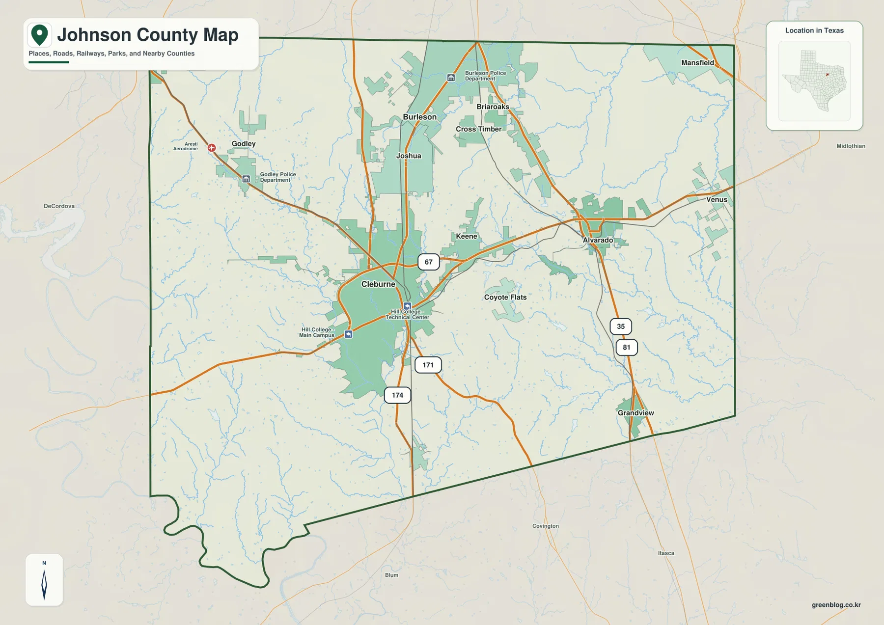
The ranked city map strips away much of the road detail and makes the settlement pattern easier to compare. The values printed in the supplied index are Burleson 52,918, Cleburne 34,344, Joshua 8,550, Venus 6,745, Keene 6,691, and Alvarado 6,307. The contrast between the top two cities and the remaining four is immediately visible. It also confirms an important point about the county: the county seat and the largest indexed city are not the same place. Cleburne is the administrative center, while the largest value on this map belongs to Burleson near the northern boundary.
The positions of the smaller cities help explain the county’s internal layout. Joshua sits between Burleson and Cleburne on the northwestern side of the central corridor. Keene is close to Cleburne, and Alvarado is farther east near the major north-south highway line. Venus sits near the eastern edge. The map also labels Tarrant County to the north, Parker and Hood counties to the west, Ellis County to the east, and Hill, Bosque, and Somervell counties around the south and southwest. These surrounding names make the Johnson County outline easier to place without relying on a separate statewide map.
The Nolan River system dominates the west while Chambers Creek branches cross the east
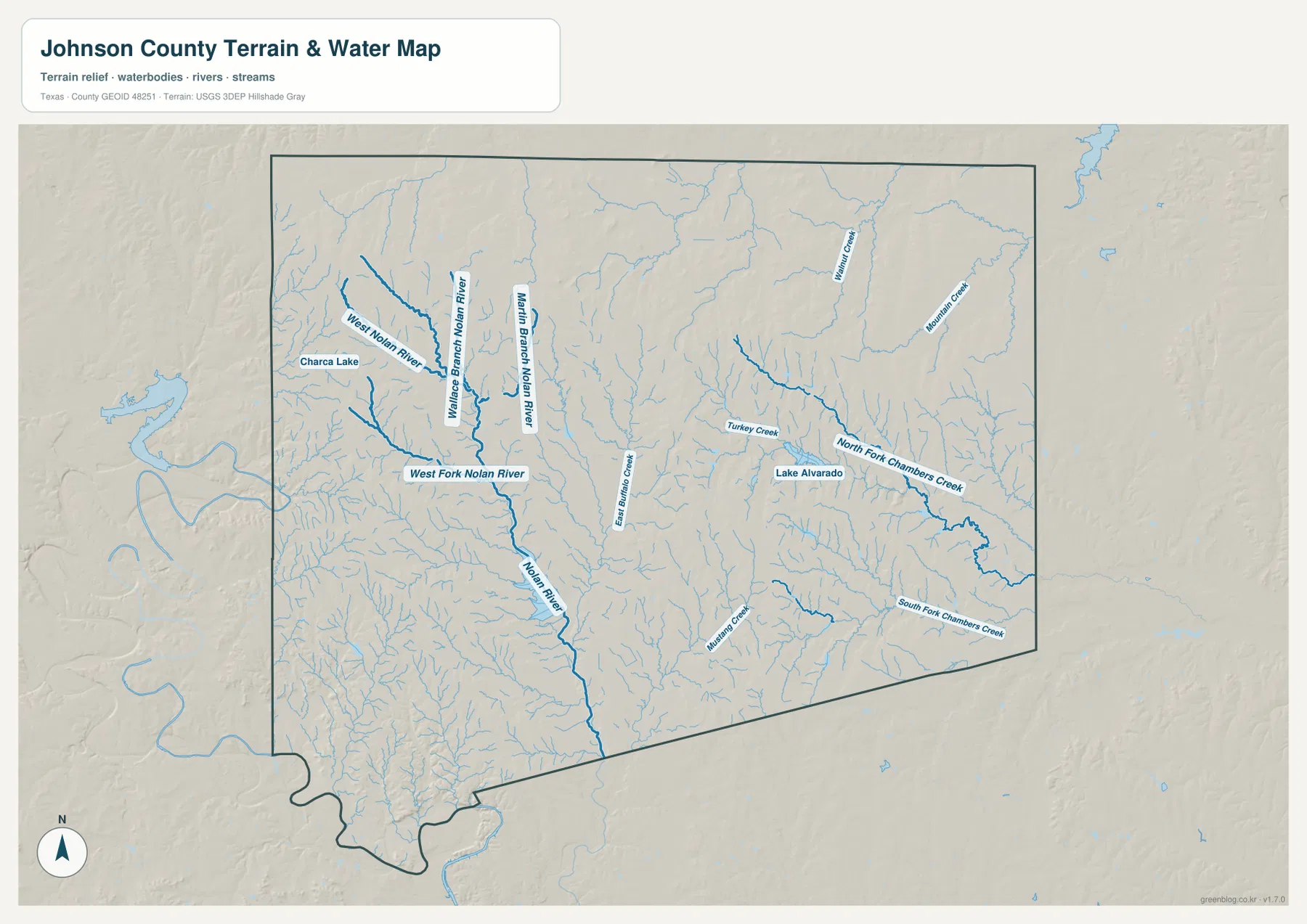
The terrain-and-water map gives names to features that appear only as thin blue lines on the general map. In the western and central part of the county, West Nolan River, Middle Branch Nolan River, and West Fork Nolan River are all labeled separately before the Nolan River continues south. Charca Lake is shown near the western side outside or close to the county boundary, and East Buffalo Creek appears in the central portion. This concentration of named branches makes the Nolan system one of the clearest physical references on the supplied maps.
The eastern half has a different set of labels. Walnut Creek and Mountain Creek appear in the northeast, while Turkey Creek and Lake Alvarado are closer to the middle east. North Fork Chambers Creek runs across the eastern side, and South Fork Chambers Creek is labeled farther south. Mustang Creek appears in the south-central area. The result is a county with several drainage lines rather than one river running through every community. If the goal is to locate a particular stream or lake, this map is much easier to use than the general road map.
The water layer should be treated as a location map, not as a live hydrology or flood-warning product. A labeled creek does not indicate present flow, flood depth, or road-crossing conditions. For classroom work, however, the named branches are useful for comparing western and eastern drainage. They can also be placed beside the city map to see which water features are closest to Cleburne, Alvarado, and the smaller communities.
Elevation drops from the western hills toward the eastern side
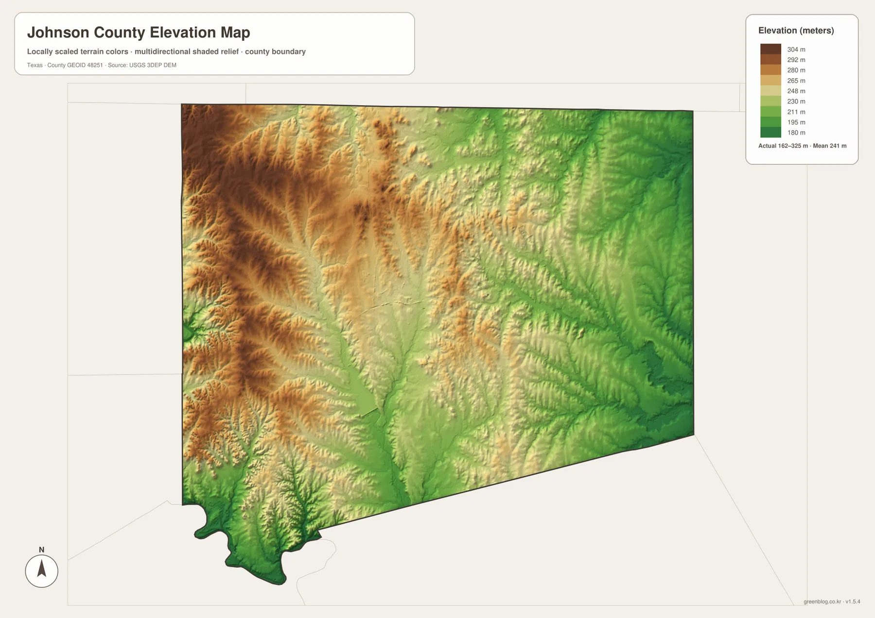
The supplied elevation map shows an actual mapped range of about 162 to 325 meters, with a mean near 241 meters. Brown and dark tan tones cover much of the west, especially the northwest and western edge, where the shaded relief shows repeated ridges and valleys. Moving toward the center, the colors become yellow and light green. The eastern and southeastern portions are dominated by greener tones, indicating lower elevations. The county therefore has a broad west-to-east elevation difference that is easy to see even without studying individual contour lines.
This is more useful than describing Johnson County as uniformly flat. The western side contains the highest terrain shown in the package, while the eastern side around Venus and the Alvarado direction sits within lower color bands. Cleburne is positioned between those two extremes. The southwestern extension also shows strong relief near the irregular boundary before dropping into lower ground. Comparing this layer with the road map helps explain where a city or highway lies within the larger terrain pattern without making assumptions about exact road grades.
Comparing the four maps reveals different sides of the same county
Cleburne is a useful example of how the maps complement one another. The general map places the city at a junction of U.S. 67 and several state highways. The city index ranks it second among the six displayed communities. The water map places the broader central and western area near the Nolan River network, and the elevation map shows Cleburne between the higher western terrain and lower eastern ground. Each layer answers a different practical question: where the roads go, how the selected cities compare, where named water features are located, and how the land rises or falls.
Burleson and Joshua provide another useful comparison. They are prominent on the city map and lie in the more densely settled north, but the elevation layer shows that the north is not a single uniform surface. The northwest contains higher ground than much of the northeast. Farther east, Alvarado and Venus are easier to understand when the highway corridors, Lake Alvarado, Chambers Creek tributaries, and lower elevation colors are considered together. That combination is more informative than repeating a generic description of urban and rural areas.
The irregular southwest boundary makes neighboring counties useful orientation points
Johnson County does not have a simple rectangular outline. The north and east sides are comparatively straight, but the southwest drops into an irregular extension with several curves before the boundary returns toward the south. The city-index map labels nearby counties around the perimeter: Tarrant to the north, Parker and Hood to the west, Ellis to the east, and Hill, Bosque, and Somervell around the southern and southwestern sides. Those labels are helpful when a road or water feature approaches the edge of the map.
Specific towns make those directions even easier to remember. Burleson sits close to the northern boundary toward Tarrant County. Venus lies near the eastern side toward Ellis County. Grandview is a useful southeastern reference, and Godley helps orient the western side. Cleburne remains near the central part of the county, so it works well as a starting point before following a highway outward toward one of the neighboring counties.
Choose the map that matches the detail you need
The general map is the best choice when you need roads, the county boundary, nearby communities, and the overall position of Cleburne in one view. Use the city index when you want a cleaner comparison of Burleson, Cleburne, Joshua, Venus, Keene, and Alvarado. The terrain-and-water map is designed for named rivers, creeks, and lakes, while the elevation map is the clearest way to show the higher western side and lower eastern side. Keeping these purposes separate makes the maps easier to read, especially on a classroom handout or printed reference sheet.
The download archive contains high-resolution JPG copies of all four maps shown on this page. These larger files are more useful than browser screenshots when labels need to stay legible or when the maps are prepared for A3 printing. Download the ZIP below, then use the county map, city map, water map, or elevation map according to the task.
Frequently Asked Questions
Which city is largest on the supplied Johnson County city index?
Burleson is ranked first at 52,918, followed by Cleburne at 34,344. Cleburne is the county seat, but the largest value printed in the supplied city index belongs to Burleson near the northern boundary.
Which named water features stand out on the Johnson County water map?
The western and central side includes West Nolan River, Middle Branch Nolan River, West Fork Nolan River, and Nolan River. In the east, Lake Alvarado and the North Fork and South Fork of Chambers Creek are among the clearest labels.
Where is the highest terrain shown on the elevation map?
The higher terrain is concentrated in the west, especially the northwest and western edge. The map shows an actual elevation range of about 162 to 325 meters and a mean near 241 meters, with lower green tones becoming more common toward the east.
Sources and Reference Data
For official source layers and additional checking, see the U.S. Census Bureau TIGER/Line Shapefiles for boundary and road data, USGS National Hydrography for named water features, and the USGS 3D Elevation Program for elevation data.
Map File Information
The archive includes high-resolution JPG files for the Johnson County map, city map, terrain-and-water map, and elevation map.
- File Type: JPG
Related Maps
- Parker County Texas map
- Somervell County
- Tarrant County Texas map
- Navarro County Texas map
- Rockwall County Texas map
Green Map creates custom-edited map images using open geographic data sources such as geoBoundaries, Natural Earth, OpenStreetMap, and government open data. These maps are edited visual materials, not raw data files, and are provided for education, documents, presentations, and graphic reference.