Union Parish in northern Louisiana is a rural parish organized around Farmerville and the broad waters of Lake D’Arbonne. Bernice, Spearsville, and Lillie are spread across the west and northwest, Marion anchors the northeast, and Downsville lies in the southern extension. LA 2, LA 15, and LA 33 provide the clearest references around Farmerville, while U.S. 167 helps with the western side. This page explains those settlement, road, lake, and creek relationships, and the matching high-resolution JPG map files can be downloaded together in a ZIP.
Farmerville is the parish seat. Louisiana’s official Union Parish profile lists Farmerville, Bernice, and Marion as towns and Downsville, Junction City, Lillie, and Spearsville as villages. On the supplied map, Farmerville is also the strongest road center and sits very close to Lake D’Arbonne. Starting there and then placing Bernice to the west, Marion to the northeast, Downsville to the south, and Spearsville and Lillie to the northwest creates a simple framework for the entire parish.
Table of Contents
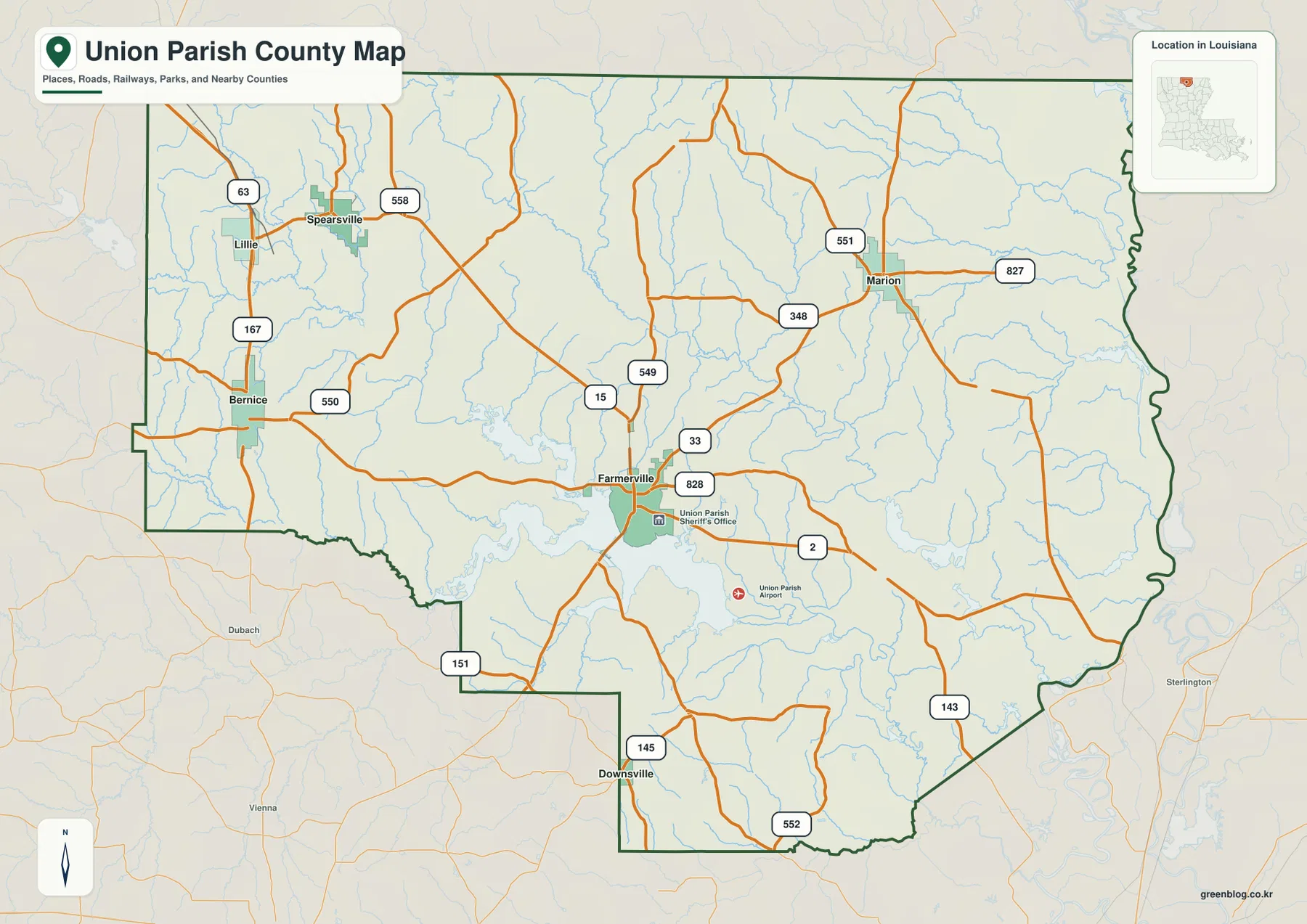
Farmerville is the road center where LA 2, LA 15, and LA 33 divide the parish
The general map places Farmerville slightly south of center, with LA 2 crossing east-west and LA 15 and LA 33 creating important north-south connections. LA 828 serves the east and southeast side of town, while LA 549 approaches from the north. Because no interstate dominates the central parish, these state highways provide the most useful first references.
LA 2 continues east toward the Morehouse Parish side, and LA 143 becomes a strong reference farther southeast. LA 145 and LA 151 help locate Downsville and the stepped southern boundary. The road pattern remains relatively open between communities, with large rural spaces and many small waterways occupying the areas between the main routes.
Bernice, Spearsville, and Lillie divide the western and northwestern countryside
Bernice is the clearest settlement on the western side and lies close to U.S. 167. LA 550 extends east from the town, while Spearsville and Lillie sit farther north. Around Spearsville, LA 558 provides an eastward road, and LA 63 and U.S. 167 establish the broader north-south direction near the western boundary.
These communities are smaller and farther apart than the Farmerville area. The spaces between them contain numerous narrow creeks and local roads rather than dense blocks of development. Using Bernice as the western anchor and then placing Spearsville and Lillie above it makes the entire west side much easier to understand without memorizing every route number.
Marion provides a clear northeastern reference near LA 551 and LA 827
Marion is the strongest town label in the northeast. LA 551 reaches the area from the north-central side, LA 827 continues east, and LA 348 approaches from the west. Several smaller roads branch south and southeast from the same area. Marion’s position close to the irregular eastern boundary makes it especially useful for understanding the parish’s northeastern width.
The road map around Marion looks relatively sparse, but the water map reveals a dense system of tributaries. Big Cane Creek and the Bayou de Loutre system help explain why roads do not form a perfect grid. In this part of the parish, waterways and state routes share the job of providing geographic orientation.
The ranked city index spreads six selected communities across the parish
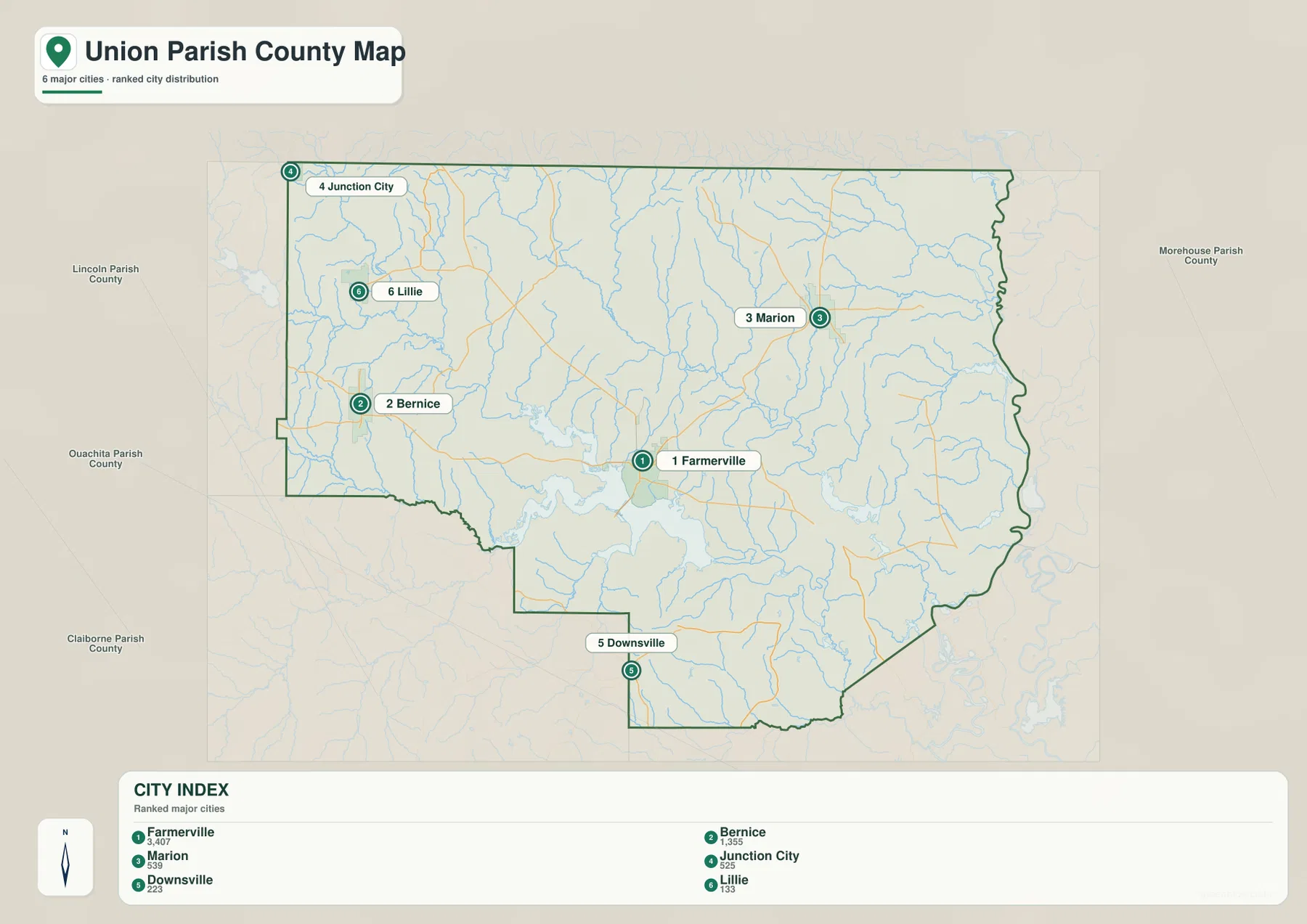
The city-index graphic ranks Farmerville number 1, Bernice 2, Marion 3, Junction City 4, Downsville 5, and Lillie 6. These numbers are rankings, not straight-line or driving distances from Farmerville. Farmerville lies near the center-south, Bernice and Lillie are to the west, Marion is northeast, Junction City is near the northwestern edge, and Downsville occupies the southern extension.
Spearsville is important on the detailed map but is not included in the six-place index. The city graphic should therefore be used as a simplified comparison of selected communities rather than a complete municipality list. For actual routes, smaller settlements, and boundary detail, the general parish map remains the better reference.
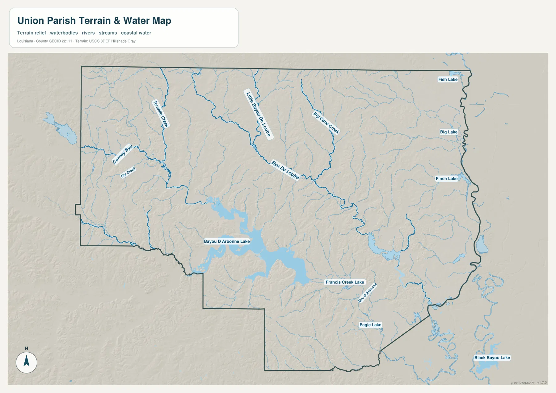
Lake D’Arbonne dominates the water map beside Farmerville
The strongest water feature is Bayou D’Arbonne Lake, commonly known as Lake D’Arbonne, immediately southwest of Farmerville. Long arms of the lake extend into the surrounding countryside, giving it a much more complex shape than a simple round reservoir. Louisiana State Parks operates Lake D’Arbonne State Park in Farmerville, reinforcing the lake’s importance as one of the parish’s best-known geographic features.
Francis Creek Lake appears southeast of the main lake, and Eagle Lake lies farther south. Black Bayou Lake is visible beyond the southeastern parish edge and provides broader regional context. Around Farmerville, the large lake is often a faster orientation clue than any individual secondary road because so many local routes curve around its arms and tributaries.
Bayou de Loutre and Big Cane Creek organize the northern and eastern drainage
Bayou de Loutre is the strongest named channel across the north-central and eastern interior. Little Bayou de Loutre joins the same general drainage area farther north, while Big Cane Creek runs through the eastern side. Trimble Creek provides another recognizable stream in the northwest around the Spearsville–Lillie side.
Fish Lake, Big Lake, and Finch Lake appear close to the eastern boundary, adding small but useful water references around the Marion side. These features are far smaller than Lake D’Arbonne, but they help distinguish the eastern lowlands and boundary area. The water map is intended for general geographic reference only; it does not provide flood-zone status, water depth, navigability, dam or levee condition, or legal property boundaries.
Using Farmerville and Lake D’Arbonne together makes the parish easier to read
A practical first pass begins with Farmerville and the LA 2–LA 15–LA 33 junction. From there, place Bernice to the west, Marion to the northeast, and Downsville to the south, then add Spearsville and Lillie in the northwest. Smaller state highways make more sense once those settlement anchors are already in place.
For water features, use Lake D’Arbonne as the large central-southwestern reference, then follow Bayou de Loutre through the north-central interior and Big Cane Creek on the eastern side. The general map is best for communities and roads, the city index for the six selected places, and the terrain-and-water map for the lake, creeks, and smaller water bodies. The close relationship between Farmerville and Lake D’Arbonne is the most distinctive feature tying the map types together.
High-resolution JPG files preserve lake arms and minor road labels
The downloadable ZIP contains the original JPG files corresponding to the three previews on this page: the general parish map, the ranked city map, and the terrain-and-water map. Each original image is 3638 by 2572 pixels, providing more room to inspect route numbers, community names, creek labels, and the long arms of Lake D’Arbonne than the web preview. The larger format is especially useful around the eastern small lakes and northwestern local roads.
Choose the general map when Farmerville, the main state roads, and the parish boundary need to appear together. Use the city index for a quick comparison of the six selected communities. The water map is the better choice for Lake D’Arbonne, Bayou de Loutre, Big Cane Creek, and the smaller lakes and tributaries. These are general reference maps rather than legal boundary, survey, flood-risk, or real-time navigation products.
Frequently Asked Questions
What is the parish seat of Union Parish?
Farmerville is the parish seat. Louisiana’s official parish profile identifies Farmerville as the seat, and the supplied map also makes it the clearest road center near LA 2, LA 15, LA 33, and Lake D’Arbonne.
Do the numbers 1 through 6 on the city map show distance from Farmerville?
No. They are rankings for Farmerville, Bernice, Marion, Junction City, Downsville, and Lillie, not straight-line or driving distances. Actual travel mileage and time should be checked with the general road map and current navigation information.
Can the Lake D’Arbonne and creek map be used for flood or boating decisions?
No. It is a general geographic reference showing Lake D’Arbonne, Bayou de Loutre, Big Cane Creek, and nearby lakes and tributaries. It does not provide flood-zone classifications, water depth, navigability, dam or levee condition, or legal property boundaries. Those decisions require current specialized information.
Map File Information
The ZIP contains the original high-resolution JPG files corresponding to the general parish map, ranked city map, and terrain-and-water map shown on this page.
- Included Files: parish map JPG, ranked city map JPG, terrain-and-water map JPG
Related Maps
Sources and references
For parish-seat and municipality information, see the Louisiana.gov Union Parish Profile and Union Parish Police Jury. Lake information and local context are available from Louisiana State Parks — Lake D’Arbonne State Park. General boundary data are documented by the U.S. Census Bureau TIGER/Line Shapefiles, and national water-feature data are documented through USGS National Hydrography.
Green Map creates custom-edited map images using open geographic data sources such as geoBoundaries, Natural Earth, OpenStreetMap, and government open data. These maps are edited visual materials, not raw data files, and are provided for education, documents, presentations, and graphic reference.