Haskell County in north-central West Texas is a place where widely spaced towns, long highways, creek valleys, and a large reservoir are easier to understand when they are viewed together. Haskell sits a little south of the county’s center, Rule lies to the west, Rochester and O’Brien are in the northwest, Weinert is farther northeast, and Stamford appears near the southern edge. You can download the original high-resolution JPG map files from the map file box below after using the page previews to choose what you need.
The maps show more than an administrative outline. The western half contains broad higher ground, while the eastern half is cut by a denser network of creeks and lower valleys. Lake Stamford stands out in the southeast, and the Double Mountain Fork Brazos River follows the western side of the county. Reading roads, settlements, water, and elevation together makes it much easier to see why Haskell County does not look the same from one side to the other.
Table of Contents
Haskell is the easiest road reference in the middle of the county
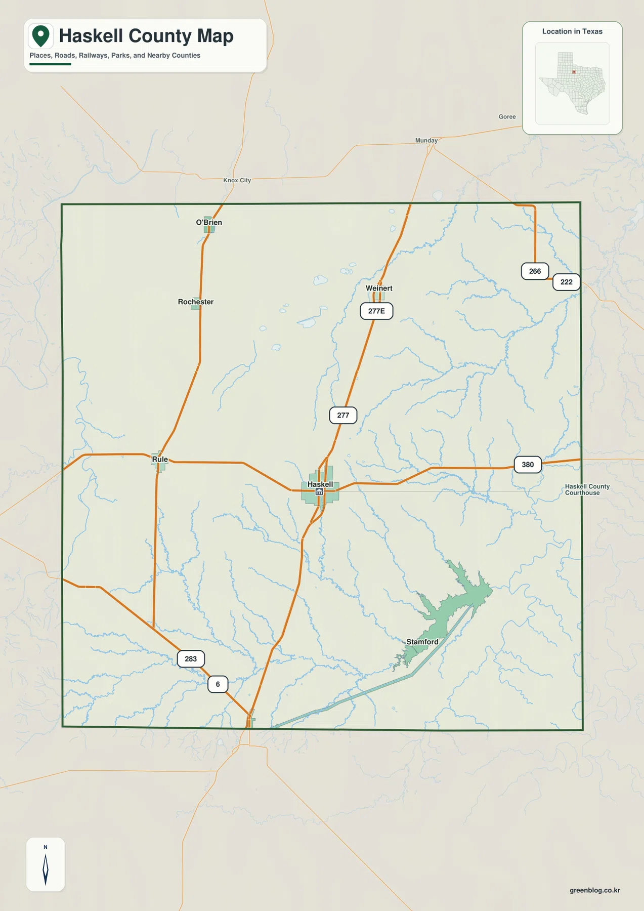
On the county map, Haskell is the clearest place to start because two of the most visible routes meet there. U.S. 277 runs south from the Weinert side toward Haskell and continues beyond the county, while Highway 380 crosses from Rule through Haskell toward the eastern boundary. That arrangement gives Haskell a strong position for understanding travel in several directions without treating the county as a simple square grid.
The western side has its own pattern. Rule sits on the east-west road leading toward Haskell, while Rochester and O’Brien are farther north on the same broad western side of the county. Road shields for 283 and 6 appear in the southwest, and 222 and 266 are shown near the northeast edge. Because the communities are separated by large rural areas, these few main corridors matter more visually than the many smaller local roads that would be present at a larger scale.
The city map shows two different settlement groups
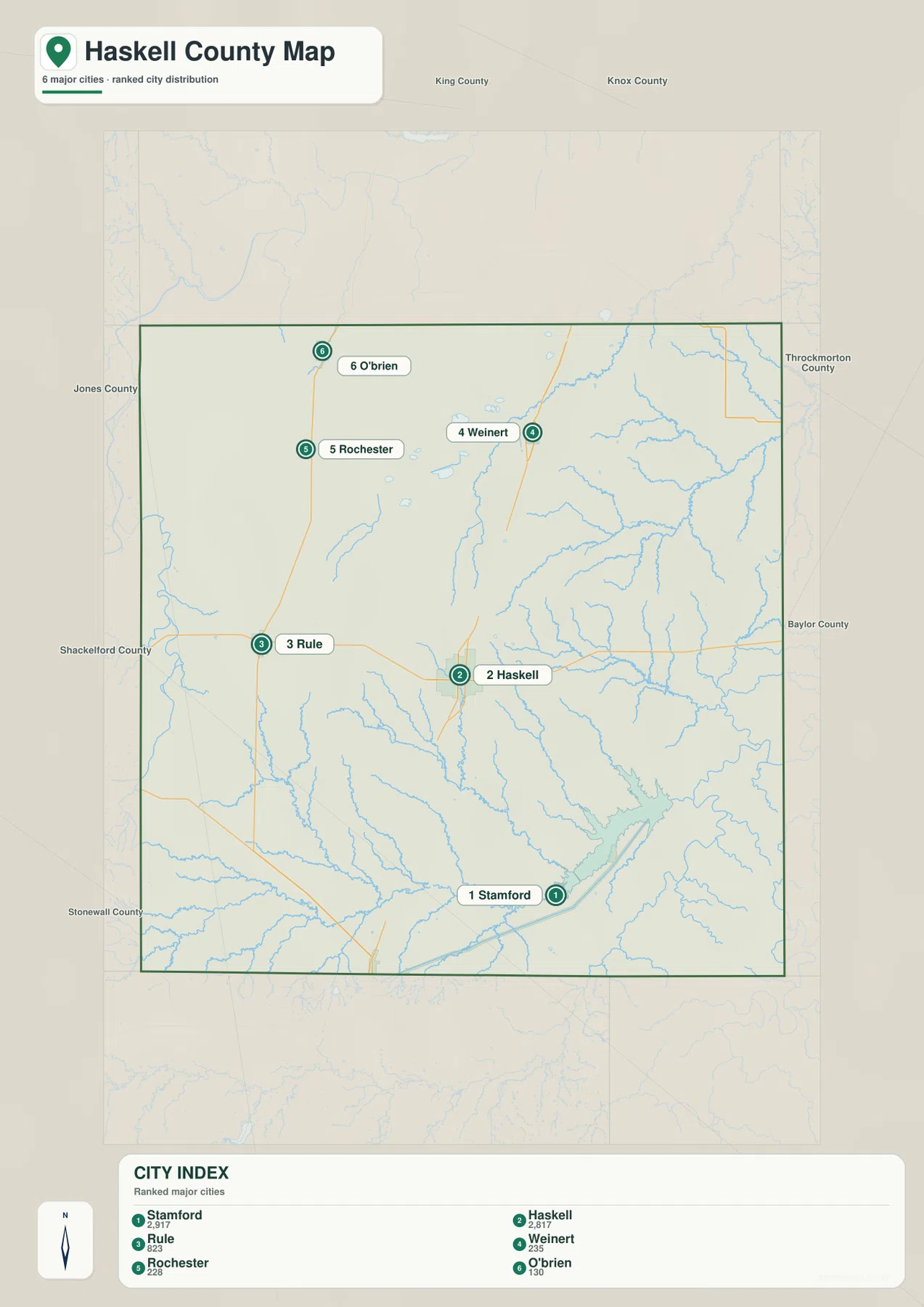
The ranked city map separates the southern and northern parts of the county especially well. Stamford and Haskell are the two largest places shown in the index, followed by Rule, Weinert, Rochester, and O’Brien. Stamford is near the south edge and Haskell is farther north, while Rule sits west of Haskell. In the north, Rochester and O’Brien form a western pair and Weinert stands apart to the east. The result is a scattered settlement pattern rather than one continuous line of towns.
This distribution is useful when a road map feels too busy. A visitor trying to find Rochester or O’Brien can first locate the northwestern cluster, while someone looking for Weinert can move to the northeast side without following every road symbol. Haskell remains the central reference for most of the map, but the spacing shows why trips between small communities can cross long stretches of open country. Stamford, by contrast, sits close to the reservoir and the lower terrain near the southern edge, giving it a different geographic setting from the northern towns.
Creeks and Lake Stamford reshape the eastern and southern map
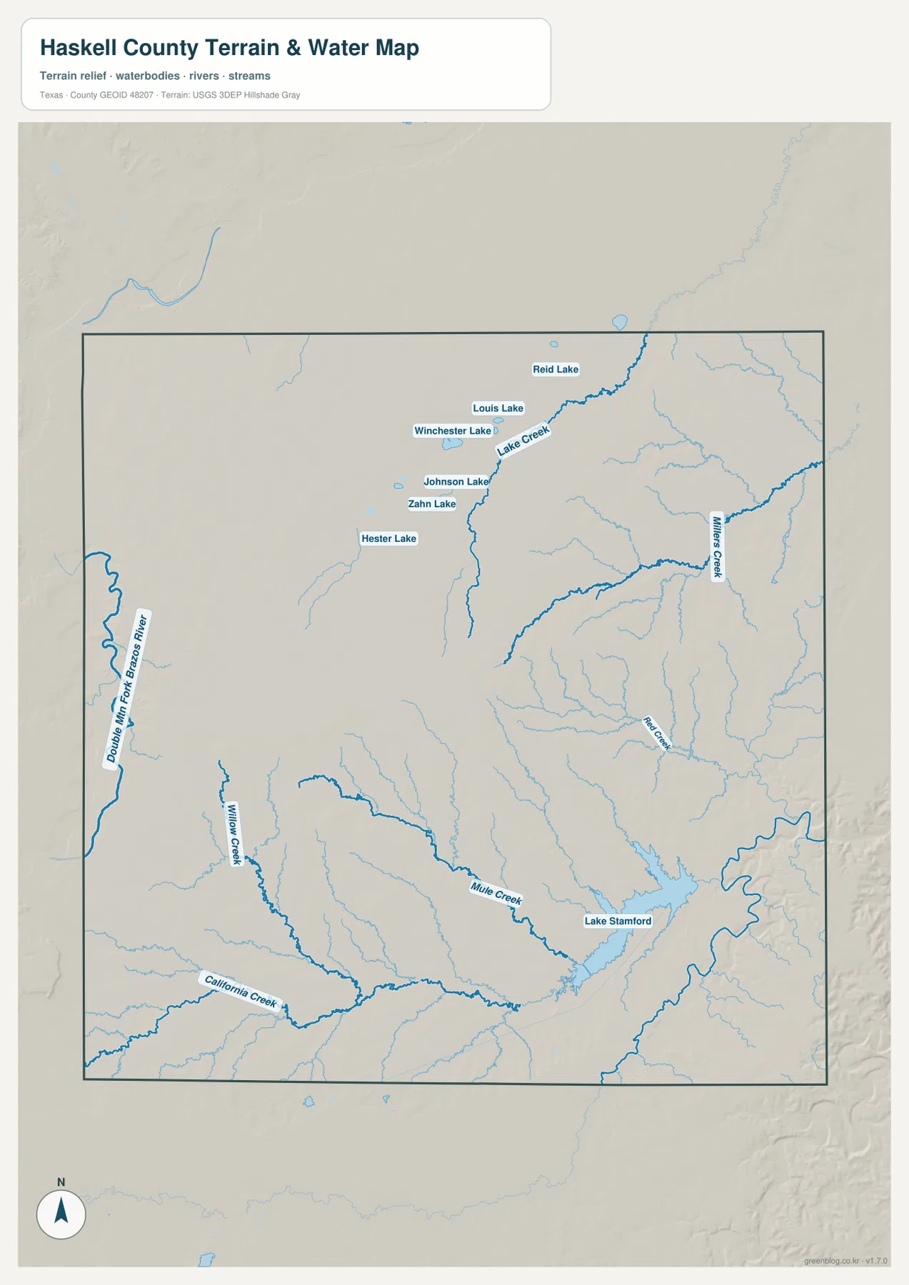
The water and terrain map changes the emphasis from highways to drainage. Along the western edge, the Double Mountain Fork Brazos River forms a prominent north-south watercourse. Willow Creek and California Creek are visible in the southwest, while Mud Creek crosses the southern interior toward Lake Stamford. Farther east, Miller Creek and a dense set of smaller tributaries cut through the lower terrain. In the northeast, Lake Creek and its branches create another well-defined drainage area.
Lake Stamford is the largest labeled water body on the map and provides a strong landmark in the southeast. A group of smaller named lakes appears farther north and west, including Hester Lake, Zahn Lake, Johnson Lake, Winchester Lake, Louis Lake, and Reid Lake. These labels make the map useful for comparing the distribution of surface water, but it should not be treated as a flood-risk map, a parcel map, or a navigation chart. Its purpose is to show where major rivers, creeks, and water bodies sit in relation to the county’s terrain.
Elevation falls from the western uplands into eastern creek valleys
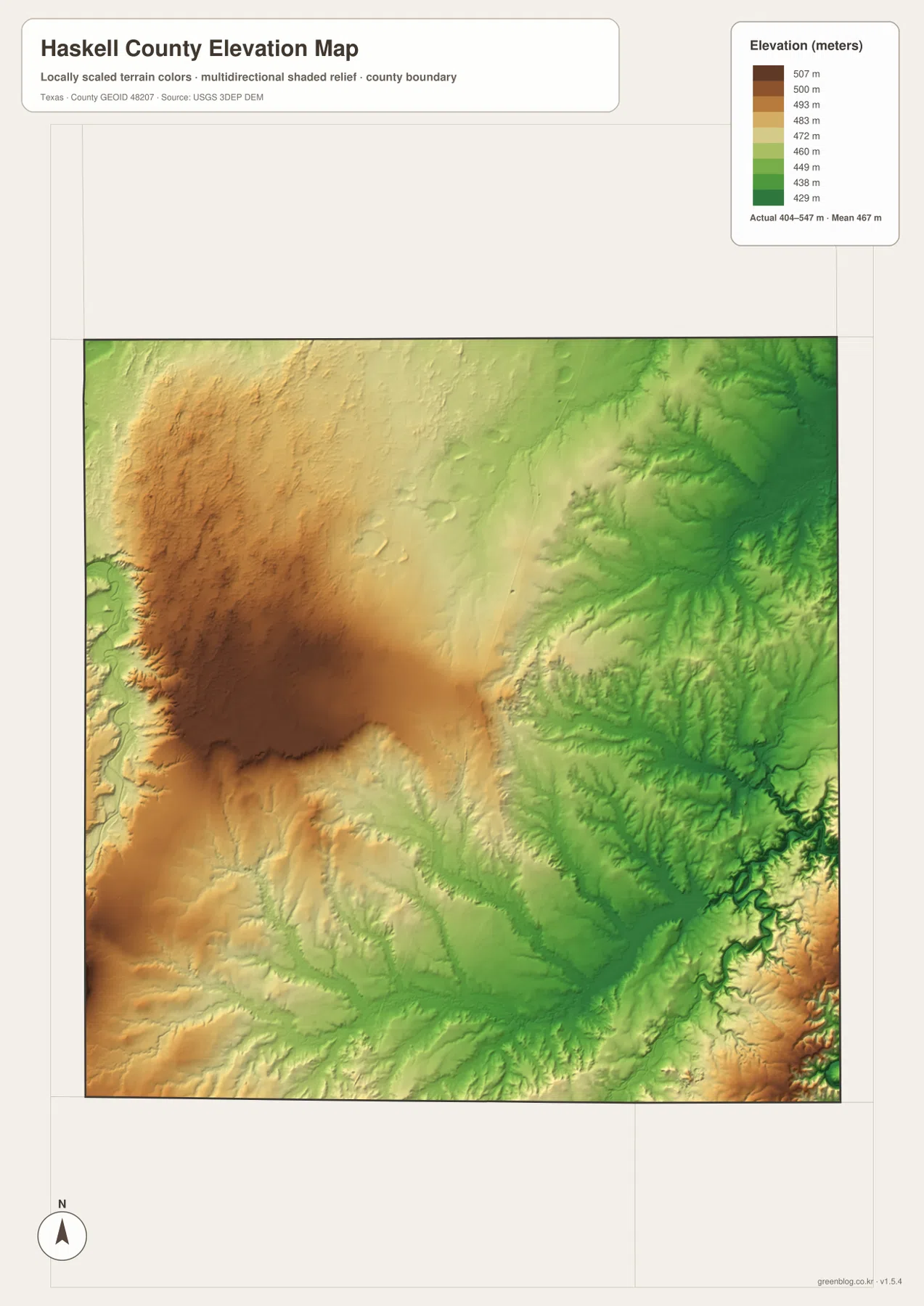
The elevation map makes a strong west-to-east contrast visible even without town labels. The legend gives an actual elevation range of about 404 to 547 meters, with a mean of about 467 meters. Brown and tan areas cover much of the western side and the west-central upland, while greener colors spread across the east. Narrow green cuts in the eastern half match the locations where creeks have carved lower valleys through the landscape.
The southern part also shows the transition clearly. Higher ground remains to the west, then the surface steps down toward the creek network and the Lake Stamford area. This does not mean every green area has the same elevation or every brown area is a single flat plateau; the shaded relief shows many smaller ridges and valleys inside the broader change. The map is best used to compare county-scale terrain, not as survey-grade elevation for construction, property boundaries, or engineering decisions.
Roads and waterways continue beyond the county line
The surrounding county labels provide useful orientation because the main routes do not stop at the Haskell County boundary. King and Knox Counties appear to the north, Throckmorton and Baylor Counties to the east, Jones County to the west, and Shackelford and Stonewall Counties toward the southwest. Following U.S. 277 or Highway 380 beyond the green boundary makes the regional connections much easier to understand than looking at Haskell County in isolation.
The same is true for drainage. The Double Mountain Fork Brazos River and the county’s creeks are parts of water systems that continue across administrative lines. The water map is deliberately focused on visible rivers, creeks, and lakes inside and near Haskell County, so a precise watershed boundary or regulatory flood zone should be checked with the appropriate official source. That distinction is important when the map is used for school work, local orientation, or general geographic reference.
Choose the map by the question you are trying to answer
For roads and town locations, the county overview is the most practical starting point because Haskell, Rule, Rochester, O’Brien, Weinert, U.S. 277, and Highway 380 can be seen together. The city distribution version removes much of that road detail and is better when the only goal is to compare the positions of the six ranked communities. Those two maps work well for travel orientation, classroom location exercises, and understanding how settlement is spread across the county.
The water map answers a different question. It is the better choice for locating Lake Stamford, the Double Mountain Fork Brazos River, Mud Creek, Miller Creek, Willow Creek, and the smaller lakes in the northwestern interior. The elevation map is more useful when the goal is to explain why the western side looks broader and higher while the eastern side contains deeper branching valleys. Comparing the same area across these map types gives a more complete picture without forcing all of the information onto one crowded image.
The ZIP below contains the original high-resolution JPG versions of the county, city, water, and elevation maps shown on this page. The WebP images above are convenient for browsing, while the JPG files are the better choice when you need a larger original for printing or offline reference.
Frequently Asked Questions
Which side of Haskell County is higher on the elevation map?
The western and west-central parts are generally higher, while the eastern creek valleys and much of the southeast are lower. The provided map shows an actual range of about 404 to 547 meters and a mean near 467 meters. Those values are useful for county-scale comparison rather than site-specific surveying.
Which map is best for finding Lake Stamford and the Brazos River tributaries?
Use the terrain and water map. It labels Lake Stamford, the Double Mountain Fork Brazos River, Mud Creek, Miller Creek, Willow Creek, California Creek, Lake Creek, and several smaller lakes. For flood regulations or precise watershed boundaries, use official hydrologic or emergency-management sources instead.
What is the quickest way to compare Haskell, Rule, Rochester, and O’Brien?
The city distribution map is the simplest choice because it removes most road detail and emphasizes settlement positions. Haskell is south-central, Rule is west, and Rochester and O’Brien form a northwestern pair, while Weinert sits farther east in the north. Switch to the county overview when you also need U.S. 277, Highway 380, or other route information.
Map File Information
The ZIP contains the original high-resolution JPG versions of the Haskell County county, city, water, and elevation maps.
- File Type: JPG
Related Maps
- Shackelford County Texas map
- Stonewall County Texas map
- Throckmorton County Texas map
- Taylor County Texas map
- Baylor County Texas map
Official Data and Reference Sources
- USGS The National Map Viewer — Official U.S. Geological Survey map service for viewing terrain, hydrography, roads, and other geographic layers.
- U.S. Census Bureau TIGER/Line Shapefiles — Official boundary and transportation geography files used for county and road reference.
- USGS National Hydrography — Official reference for rivers, creeks, lakes, and other U.S. hydrographic features.
- USGS 3D Elevation Program — Official USGS elevation program for terrain and elevation data.
Green Map creates custom-edited map images using open geographic data sources such as geoBoundaries, Natural Earth, OpenStreetMap, and government open data. These maps are edited visual materials, not raw data files, and are provided for education, documents, presentations, and graphic reference.