To understand Ector County, begin with Odessa and work outward toward West Odessa, Goldsmith, and Gardendale. On a Ector County Texas map, these places become more meaningful when they are read together with Permian Basin and semiarid plains. The goal is not simply to name locations, but to explain how settlement, transportation, physical geography, economic activity, and connections to nearby counties fit together.
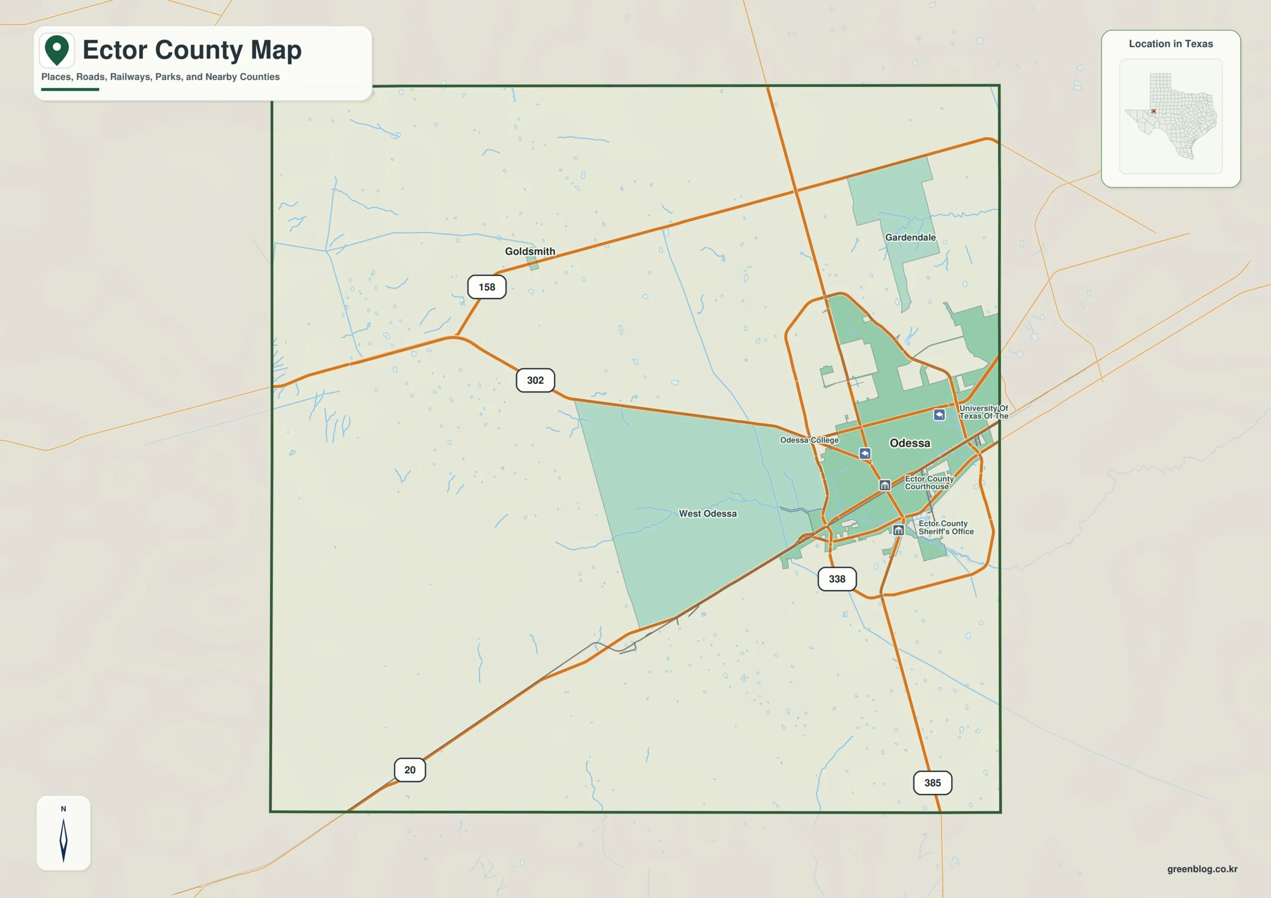
Table of Contents
Quick Facts
- County seat: Odessa
- Location in Texas: West Texas in the central Permian Basin
- Selected communities: Odessa, West Odessa, Goldsmith, Gardendale
- Key geographic features: Permian Basin, semiarid plains, oilfield landscape
- Adjacent areas: Andrews County, Midland County, Crane County, Ward County, Winkler County
County Structure and Settlement Pattern
Ector County cannot be understood from Odessa alone. Connecting West Odessa, Goldsmith, and Gardendale reveals whether settlement is clustered, linear, or widely dispersed, and whether the outer parts of the county depend on different local centers. This is useful for interpreting rural service areas and suburban expansion.
For this county specifically, the mapped settlement pattern can be summarized this way: Odessa occupies the central-eastern part, West Odessa spreads west, Goldsmith lies northwest, and Gardendale is toward the northeast. Urban and industrial development is far denser here than in surrounding rural counties.
Road Network and Everyday Movement
The road system is best interpreted as a set of functional corridors. One route may connect Odessa with West Odessa, another may carry traffic toward Andrews County, and smaller roads may serve dispersed production areas. Looking at destinations rather than road classes gives the lines on the map a practical meaning.
The county-specific road and location relationship is more concrete in the following description: Interstate 20 crosses the southern side of Odessa, while U.S. 385 and Loop 338 organize north-south and circumferential movement. Oilfield roads fill the county beyond the urban grid.
Terrain, Water, and Spatial Differences
Locate Permian Basin and semiarid plains before judging the road pattern. Together with oilfield landscape, these features help explain bends, bridge locations, straight survey roads, and differences in settlement density. Physical geography is therefore part of the transportation story rather than background decoration.
Different Roles of the County Seat and Communities
Odessa is the civic reference because it is the county seat, but West Odessa and Goldsmith may have different commercial, industrial, agricultural, residential, or tourism roles. Even Gardendale, if small, can be an important marker for the outer county. County seat, largest town, and strongest economic center should not be assumed to mean the same thing.
Economy, Services, and Land Use
Oil and gas extraction, energy services, logistics, manufacturing, health care, and retail drive the economy The economy is not printed as a separate map layer, but its effects appear in settlement size, road access, and land subdivision. Comparing Odessa with West Odessa and Goldsmith provides clues to where daily services, employment, and freight movement are concentrated.
The local economic and service context is more specific than a general regional description: Oil and gas extraction, energy services, logistics, manufacturing, health care, and retail drive the economy. Odessa’s growth is closely linked with neighboring Midland, creating a two-city Permian Basin labor market.
Connections with Neighboring Counties
Looking toward Andrews County, Midland County, and Crane County places Ector County in a wider regional context. Compare outbound roads from Odessa, the continuity of Permian Basin, and the direction of service travel to judge whether the county acts as an independent center or is strongly tied to a larger nearby market.
Details That Are Easy to Miss on the Map
Begin with Odessa and West Odessa, then add Goldsmith, locate Permian Basin and semiarid plains, and only after that trace the connection toward Andrews County. Reading the layers step by step makes the map easier to interpret than trying to absorb every label at once.
Practical Uses for Printing, Teaching, and Local Research
For regional comparison, place Ector County and Andrews County at the same scale and compare terrain, road density, and settlement spacing. In a report or classroom activity, highlighting Permian Basin and semiarid plains can connect physical geography with human activity, while field planning can focus on access from each local center.
Frequently Asked Questions
What should I locate first on a Ector County map?
Start with Odessa, then find West Odessa and Goldsmith. After that, compare their positions with Permian Basin and the major road corridors to understand the settlement and travel pattern.
Why is Permian Basin important when reading the county?
Permian Basin is a useful physical reference because it can influence road alignment, settlement spacing, and land use. Reading it together with semiarid plains makes internal geographic differences easier to see.
Why compare Ector County with neighboring counties?
Routes toward Andrews County and Midland County continue beyond the administrative boundary, and regional travel, employment, and physical geography often operate across several counties.
Related Maps
- Andrews County Texas map
- Ward County Texas map
- Winkler County Texas map
- Pecos County Texas map
- Upton County Texas map
Reference
USGS The National Map Viewer — Use the official U.S. Geological Survey map service to check boundaries, hydrography, roads, terrain, and other geographic layers.
Green Map creates custom-edited map images using open geographic data sources such as geoBoundaries, Natural Earth, OpenStreetMap, and government open data.
These maps are edited visual materials, not raw data files, and are provided for education, documents, presentations, and graphic reference.