Telfair County sits in south-central Georgia, where McRae-Helena serves as the main crossroads for a largely rural county shaped by highways, small towns, the Ocmulgee river system, and low rolling terrain. This page brings those features together through four different map views. The county map shows the boundary, major roads, and named communities; the city map compares the direction and straight-line distance from McRae-Helena to other towns; the water map emphasizes rivers and creeks; and the elevation map shows where the land rises and falls. After reviewing the geography, you can download all four maps as high-resolution A3 JPG files in one ZIP archive.
The county’s layout becomes easier to understand once McRae-Helena is used as the starting point. U.S. 280 runs westward toward Milan, U.S. 23 and U.S. 341 head toward Scotland and Lumber City, and U.S. 319 and U.S. 441 run south from the county seat toward Jacksonville. Those routes make the northern part of the county look like a transportation hub, while the water and elevation maps reveal a different pattern underneath: higher, more broken ground appears mainly to the west and northwest, and lower terrain spreads toward the eastern and southern waterways.
Telfair County was created in 1807, and its first county seat was Jacksonville, a settlement associated with traffic on the Ocmulgee River. The seat later moved to McRae after the railroad changed the county’s transportation pattern. Modern McRae-Helena, formed from the merger of McRae and Helena, now occupies the strongest road junction in the county. That history gives the maps more meaning: older places such as Jacksonville and Lumber City reflect the importance of the river, while the present administrative center reflects the later importance of rail and highway connections.
Table of Contents
McRae-Helena anchors the county’s road network
The general county map is the best place to start because it puts the boundary, named towns, roads, and nearby places on the same view. McRae-Helena lies near the northern center of Telfair County, and several important highways meet there. U.S. 280 crosses the county from the west and enters the hub, U.S. 23 and U.S. 341 continue east toward Scotland and Lumber City, and U.S. 319 and U.S. 441 run south toward Jacksonville. The result is a clear spoke-like pattern in which the county seat connects the western, eastern, and southern parts of the county.
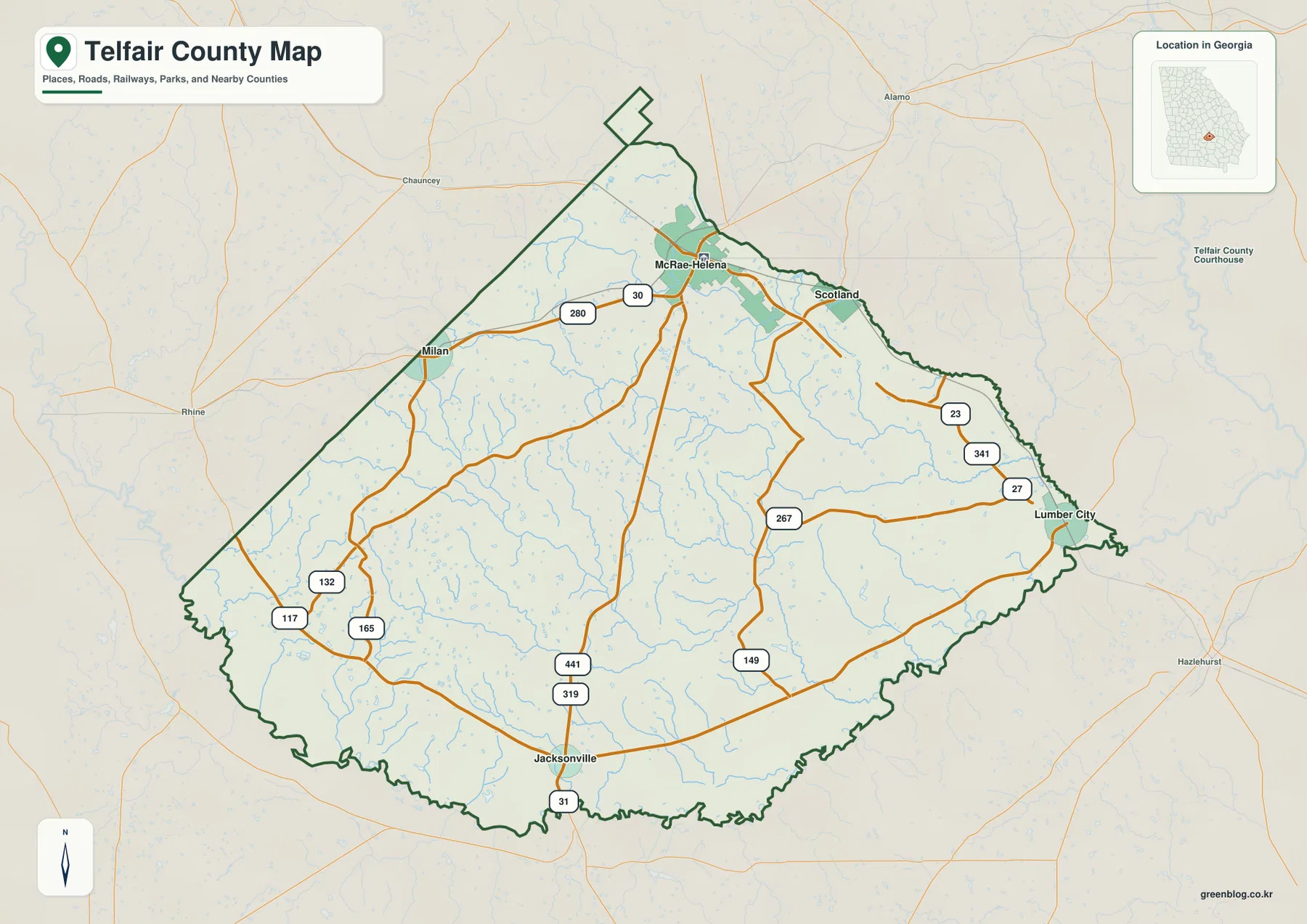
Several state routes add local connections between those main corridors. The map labels routes including 27, 30, 31, 117, 132, 149, 165, 200, and 267. They are useful for orientation, but this is not a turn-by-turn driving map and it does not attempt to show every local street, private road, or parcel line. A practical way to read it is to identify the destination town first, follow the nearest U.S. highway or state route, and then use a current navigation service if you need exact driving directions.
The irregular boundary makes the neighboring counties useful reference points
The city map labels the counties around Telfair and helps place it within the wider region. Dodge County is to the north, Wheeler County to the northeast, Jeff Davis County to the east, Montgomery County to the southeast, Coffee County to the southwest, Wilcox County to the west, and Ben Hill County to the northwest. The county outline is not a simple rectangle; it bends around river corridors and older survey lines. Seeing the neighboring counties at the same time makes it easier to understand why some roads leave Telfair quickly while others travel a longer distance inside the county.
The road pattern also explains why McRae-Helena is more useful as an orientation point than the geometric center of the county. The most important regional routes converge there, and several towns line up along those routes. For anyone comparing Telfair with nearby Georgia counties, this map is especially helpful because the inset shows the county’s position within the state while the main panel keeps enough detail to identify the local transportation structure.
Scotland is close to the hub; Jacksonville and Lumber City sit farther out
The city-connections map removes much of the extra detail and focuses on how the main communities relate to McRae-Helena. Scotland appears just to the east of the hub, Milan lies to the west, Lumber City is near the eastern edge, and Jacksonville is well to the south. The distance labels are direct, straight-line measurements rather than driving distances, so they should be used as a geographic comparison rather than a travel-time estimate. Roads curve, river crossings matter, and actual routes can add miles.
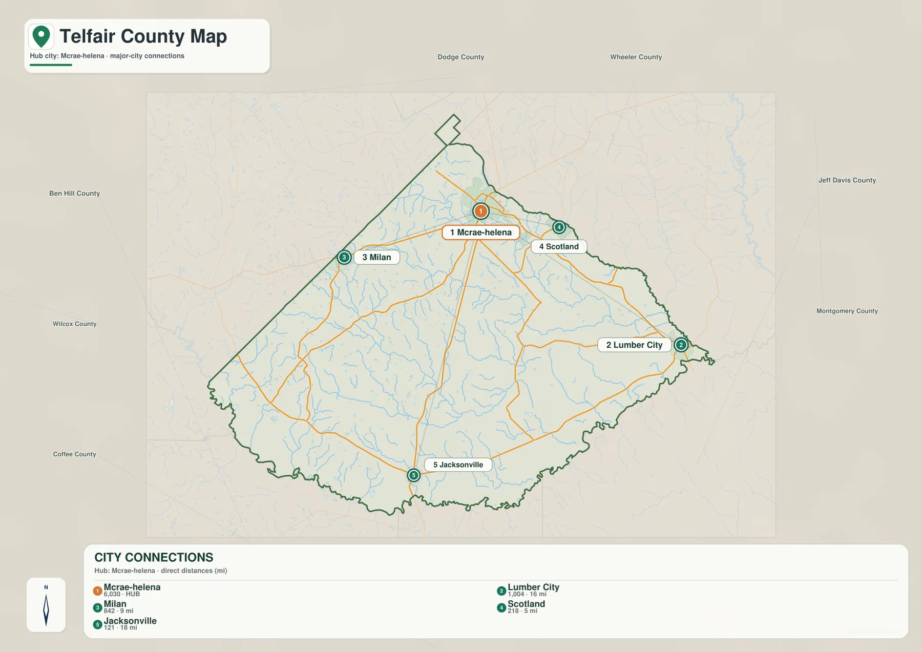
On this map, Scotland is about 5 miles from McRae-Helena in a straight line, Milan about 9 miles, Lumber City about 16 miles, and Jacksonville about 18 miles. That spread gives a simple picture of the county’s settlement pattern. McRae-Helena and Scotland form a compact northern cluster, while Lumber City and Jacksonville occupy more distant eastern and southern positions. Milan lies across the county to the west but remains closer to the hub than the two outer towns.
The locations also connect to Telfair County history. Jacksonville was the first county seat and developed near the Ocmulgee River. Lumber City grew with timber and river transportation. McRae became the county seat after the railroad created a more central transportation node, and McRae and Helena later merged in 2015. The city map therefore does more than rank places by distance: it shows how the county’s center of activity shifted from river-oriented settlements toward a road-and-rail crossroads.
For classroom or local-history work, this view is often easier to explain than the full road map. A reader can immediately see which communities sit near the county seat and which occupy the outer parts of the county. It is also useful before looking at the water map, because Jacksonville and Lumber City make more sense when their positions are compared with the Ocmulgee system.
The Ocmulgee system is joined by a dense network of creeks
The terrain-and-water map shifts attention away from roads and towns. The Ocmulgee River is labeled along the lower edge of the county, while the Little Ocmulgee River runs through the northeastern part. Between them, numerous named creeks cross the interior. Turnpike Creek, Sugar Creek, Horse Creek, Little Horse Creek, Big Horse Creek, and Alligator Creek stand out, along with smaller waterways such as Griffin Creek, Cal Creek, and Mill Creek. The pattern shows that Telfair County is drained by many branching channels rather than one isolated river corridor.
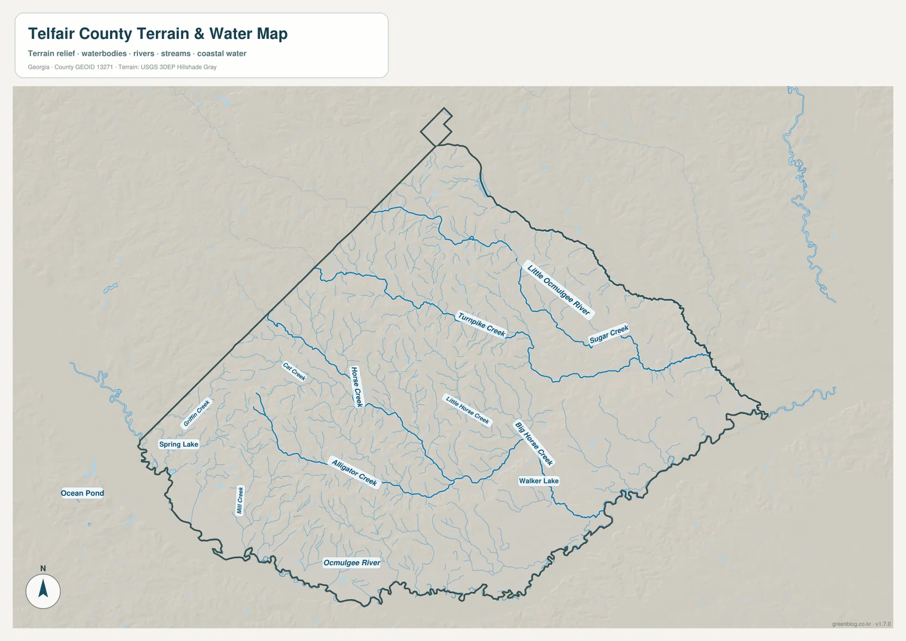
Small water bodies add another layer. Walker Lake is labeled in the south-central part of the county, while Spring Lake appears near the western edge; Ocean Pond is shown outside the county to the southwest as a nearby reference. These features are easy to miss on the general road map, but the water map separates them from the background and makes the drainage pattern much clearer. The many thin tributaries also help explain why the county’s terrain looks more dissected in some areas than a simple “flat south Georgia” description would suggest.
The river system is closely tied to local history. Jacksonville’s early role as a river port and Lumber City’s timber history reflect a period when the Ocmulgee carried people and goods before highways became dominant. That does not mean the map is a navigation chart. It does not show current channel depth, boat hazards, flood zones, property boundaries, or legal access points. Its purpose is to show where the main water features lie in relation to the county boundary and surrounding terrain.
When using the map for research, it is useful to treat the named waterways as reference features and then consult an authoritative hydrography source for technical work. The USGS National Hydrography program is a better source for detailed water-network data, while local emergency-management or flood-mapping resources should be used for flood risk. This distinction matters because a visually clear county map can show location without answering every water-related question.
Telfair County is low, but the western side is noticeably higher
Telfair County does not have mountain-scale relief, yet the elevation map makes clear that it is not completely flat. Higher ground is concentrated mainly in the west and northwest, where brown and tan colors form a series of low ridges and rolling uplands. Green colors spread more widely across the east and south, especially near the larger waterways. The map legend reports an actual elevation range of roughly 29 to 112 meters, with a mean near 63 meters.
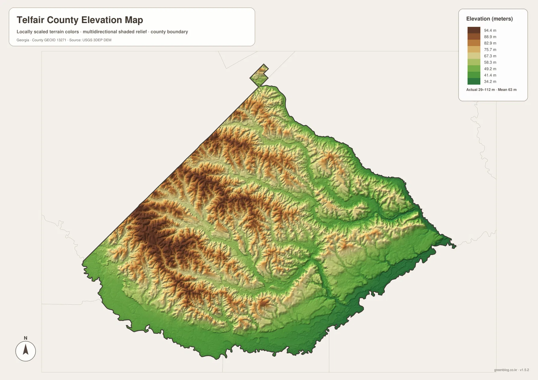
The shaded relief makes shallow valleys and ridges easier to see than they would be on a plain color surface. Some of the strongest texture appears in the western half, where numerous small drainage lines cut through the higher ground. Farther east, broad green areas follow lower corridors toward the river system. This is one of the most useful differences between the elevation map and the general county map: roads tell you how places are connected, while relief helps explain the physical land underneath those connections.
It is important not to overread the shading. The illuminated ridges are a visualization technique and do not mean the slopes are as steep as they appear on screen. The surface is generalized for county-scale reference, so it should not be treated as survey-grade or engineering-grade elevation. For construction, drainage design, precise contour work, or land surveying, use project-specific measurements and higher-resolution official elevation data.
Reading roads, water, and relief together explains the county better
The strongest geographic picture comes from comparing the maps rather than treating each one as a separate product. McRae-Helena occupies the northern transportation hub where several U.S. highways meet. Scotland sits close by to the east, while Milan, Lumber City, and Jacksonville extend the settlement pattern in different directions. Under that road network, the water map shows a web of creeks leading toward the Ocmulgee system, and the elevation map shows that many of the lower corridors lie in the eastern and southern parts of the county.
For example, the route from McRae-Helena toward Lumber City crosses the eastern side of the county where the terrain becomes lower and the water network becomes more prominent. Looking west toward Milan produces a different impression: the road connection remains clear, but the elevation map shows more rolling and higher ground. Jacksonville, near the southern part of the county, is easier to understand once its historic relationship with the Ocmulgee River is considered. These are county-specific relationships that disappear if the maps are reduced to generic “road,” “water,” and “elevation” categories.
This combined reading is useful for students, local researchers, genealogy projects, travel orientation, and presentations. A family-history researcher may begin with a town name, then use the county map to see its road connection, the water map to identify nearby rivers or creeks mentioned in old records, and the elevation map to understand the surrounding land. A classroom assignment can use the same sequence to explain why a county seat, a river town, and a highway corridor occupy different parts of the landscape.
The maps are also a reminder that administrative boundaries do not describe the whole county. Two places can be inside the same boundary but have different connections to roads, waterways, and nearby counties. McRae-Helena is oriented toward regional highways, Lumber City toward the eastern river corridor, and Jacksonville toward the southern part of the Ocmulgee landscape. Combining the four views keeps those differences visible without requiring a technical GIS application.
Choose the map that matches the question you are asking
If you only need one image, start with the type of information that matters most. The general county map is the best all-purpose reference because it combines the boundary, major towns, and main roads. The city map is simpler when the goal is to compare McRae-Helena with Scotland, Milan, Lumber City, and Jacksonville. The water map is the better choice for river and creek names, and the elevation map is most useful when the difference between western uplands and lower eastern or southern terrain matters.
- County map: use it for the county outline, town locations, and highway orientation.
- City-connections map: use it to compare direction and straight-line distance from McRae-Helena.
- Water map: use it to locate the Ocmulgee, Little Ocmulgee, and named creeks and lakes.
- Elevation map: use it to compare the higher western and northwestern ground with lower terrain toward the east and south.
For a report or presentation, two or more views often work better than one. A road map can identify a town but cannot explain the nearby drainage pattern, and an elevation map can show relief without telling you which highway reaches the place. Pairing the relevant views helps readers understand what each map is designed to show and, just as importantly, what it does not show.
The downloadable archive contains four original high-resolution A3 JPG files rather than the lighter WebP previews used in the article. They can be resized for slides or documents, or printed after checking the page orientation and printer margins. These maps are general geographic references; they should not replace legal boundary records, real-time navigation, flood determinations, or professional survey and engineering data.
Frequently Asked Questions
Why does McRae-Helena appear as the main hub on the Telfair County maps?
McRae-Helena is the county seat and the point where several major U.S. highways meet, including U.S. 280, U.S. 319/441, and U.S. 23/341. The city-connections map also uses it as the reference point for the other named towns, so it is the most practical place from which to understand the county’s road and settlement pattern.
Where are the Ocmulgee and Little Ocmulgee rivers on the water map?
The Ocmulgee River is labeled along the lower edge of the county, while the Little Ocmulgee River appears in the northeastern part. Between them, creeks such as Turnpike, Sugar, Horse, and Alligator form a branching network across the interior. The map is useful for location reference, but it is not a flood or boating-navigation product.
Can the elevation map be used for engineering or land surveying?
No. It is a county-scale reference map designed to show broad differences in relief, such as the higher western uplands and lower eastern and southern corridors. Construction, drainage design, precise contours, and boundary work require project-specific surveys and higher-resolution official data.
Map File Information
Download four high-resolution A3 JPG maps of Telfair County in one ZIP archive, covering the county, city connections, waterways, and elevation.
- File Type: four high-resolution A3 JPG files in a ZIP archive
Related Maps
Sources and References
These references provide county background and authoritative boundary, hydrography, and elevation resources. Use the most current official datasets when a project requires exact technical or legal information beyond the general reference maps on this page.
- U.S. Census Bureau QuickFacts for Telfair County
- New Georgia Encyclopedia: Telfair County
- U.S. Census Bureau TIGER/Line boundary and road data
- USGS National Hydrography
- USGS 3D Elevation Program
Green Map creates custom-edited map images using open geographic data sources such as geoBoundaries, Natural Earth, OpenStreetMap, and government open data. These maps are edited visual materials, not raw data files, and are provided for education, documents, presentations, and graphic reference.