Ness County lies in western Kansas, where Ness City provides the clearest reference point for a sparse network of small communities spread across the High Plains. K-96 crosses Ness City from west to east and US 283 runs north–south, while Bazine lies to the east and Ransom, Utica, and Brownell are grouped closer to the northern K-4 corridor. Long distances between towns make the county’s road pattern feel very different from a compact urban area. High-resolution map files are available for download in the section below.
This guide follows those town connections into the Walnut Creek drainage, the Pawnee River along the southern edge, and an elevation range of roughly 632 to 819 meters. WebP previews are available in the article, and the matching high-resolution JPG files can be downloaded together in one ZIP for printing, classroom use, or offline reference.
Table of Contents
K-96 and US 283 make Ness City the county’s easiest road reference
Ness City sits close to the middle of the county where K-96 and US 283 cross. K-96 provides the clearest east–west route toward Bazine, while US 283 connects the city with the northern part of the county and the southern boundary. Finding that intersection first makes the rest of the road network much easier to place.
The northern communities belong to a different corridor. K-4 links Utica and Ransom, and Brownell lies farther east of Ransom. K-147 and numerous local roads add detail, but the county’s broad structure can be understood from the Ness City crossroads and the northern K-4 line before examining smaller routes.
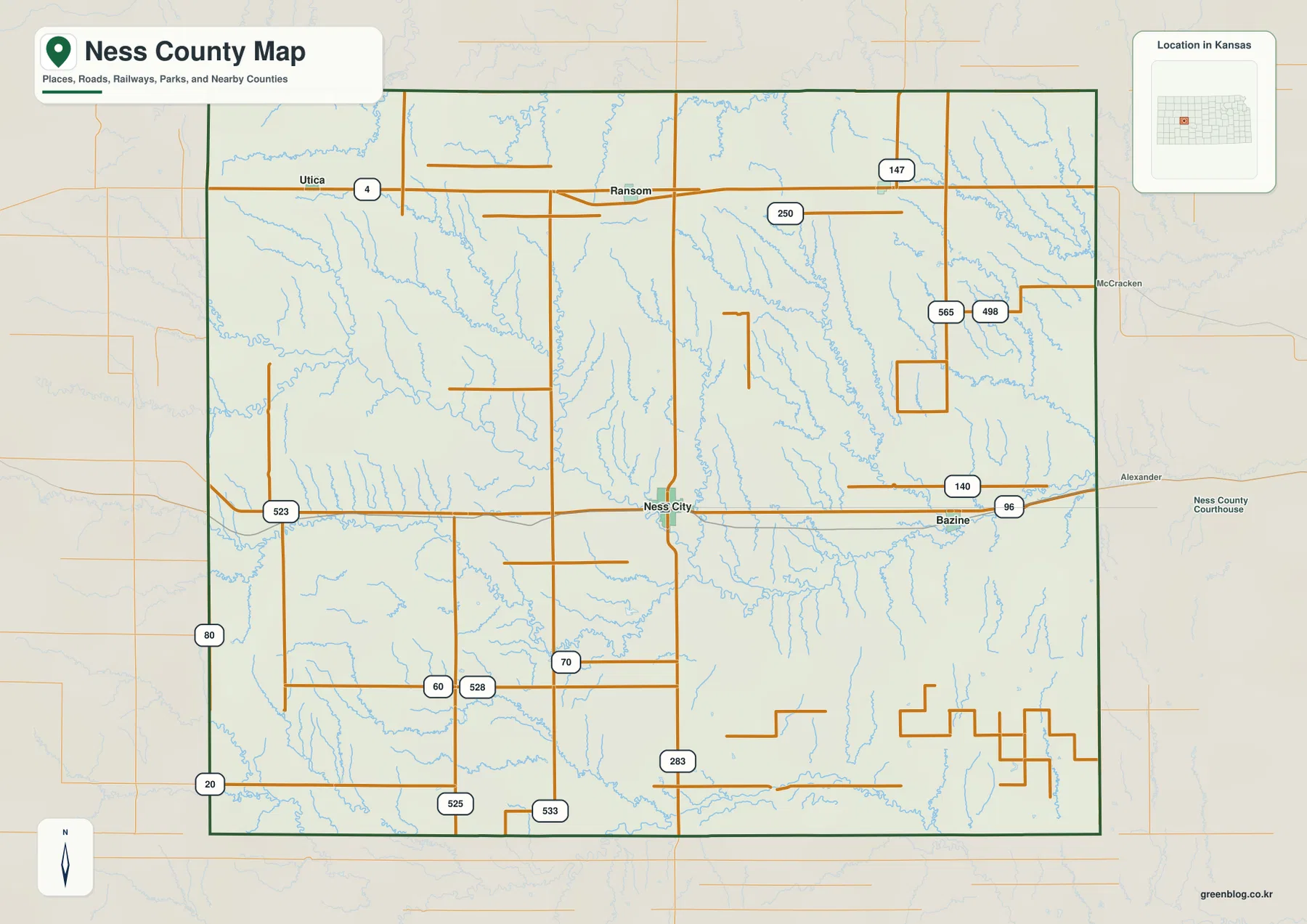
Ness County’s official website places county government offices in Ness City, and the Kansas Historical Society also identifies Ness City as the county seat. The map supports that role geographically: the town is not only an administrative center but also the strongest central road junction in the county.
Bazine lies east of the hub, while Ransom, Utica, and Brownell line the north
The city-connections panel marks Ness City as the hub with an index value of 1,162. Bazine is listed at 406 and about 12 direct miles away, while Ransom is 279 and about 13 direct miles from the hub. Brownell is shown at 14 and roughly 16 direct miles away, and Utica at 13 and about 19 direct miles.
These are map index values rather than current official population estimates, and the distance labels are straight-line measurements rather than driving distances. The geography is still useful: Bazine sits east of Ness City along the K-96 side, while Ransom is north, Utica is west of Ransom, and Brownell lies farther east along the northern corridor.
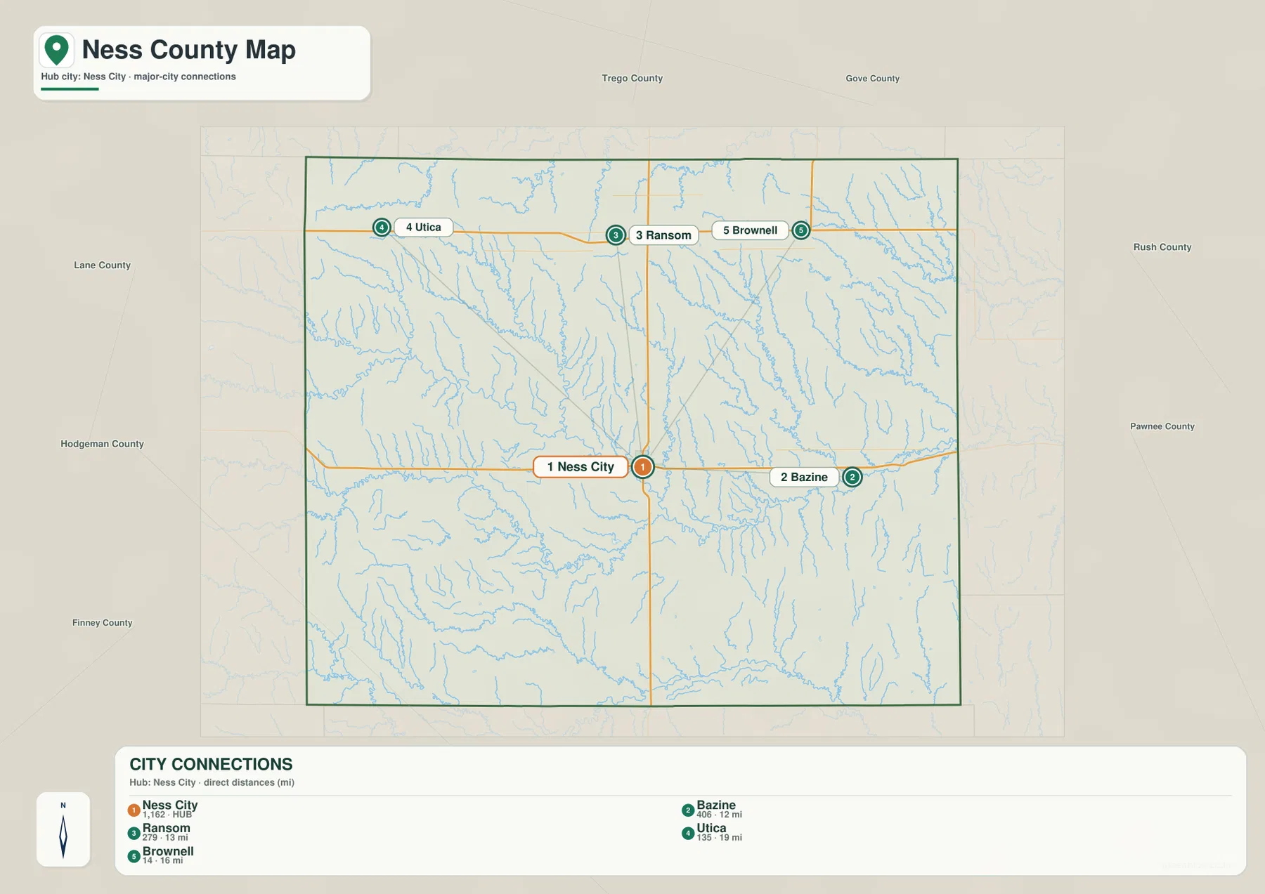
Kansas Tourism describes Ness City and the surrounding county as a western Kansas destination shaped by small-town history and agricultural landscapes. The old Ness County Bank Building, nicknamed the “Skyscraper of the Plains,” is one of the most recognizable local landmarks and reinforces Ness City’s long-standing role as the county’s main center.
The Walnut Creek forks create the county’s broadest central drainage pattern
The most complex drainage system on the water map is the Walnut Creek network. North Fork Walnut Creek and South Fork Walnut Creek cross the western and central parts of the county, receiving numerous smaller tributaries before the channels continue toward the east. Long Branch enters the same general lowland from the central interior.
Northern Ness County is cut by a different set of smaller waterways. Wild Horse Creek crosses the northwest, while North Fork Ransom Creek and Forrester Creek occupy valleys south and southwest of Ransom. Big Timber Creek descends through the northeastern area, and Alexander Dry Creek marks another named drainage east of the center.
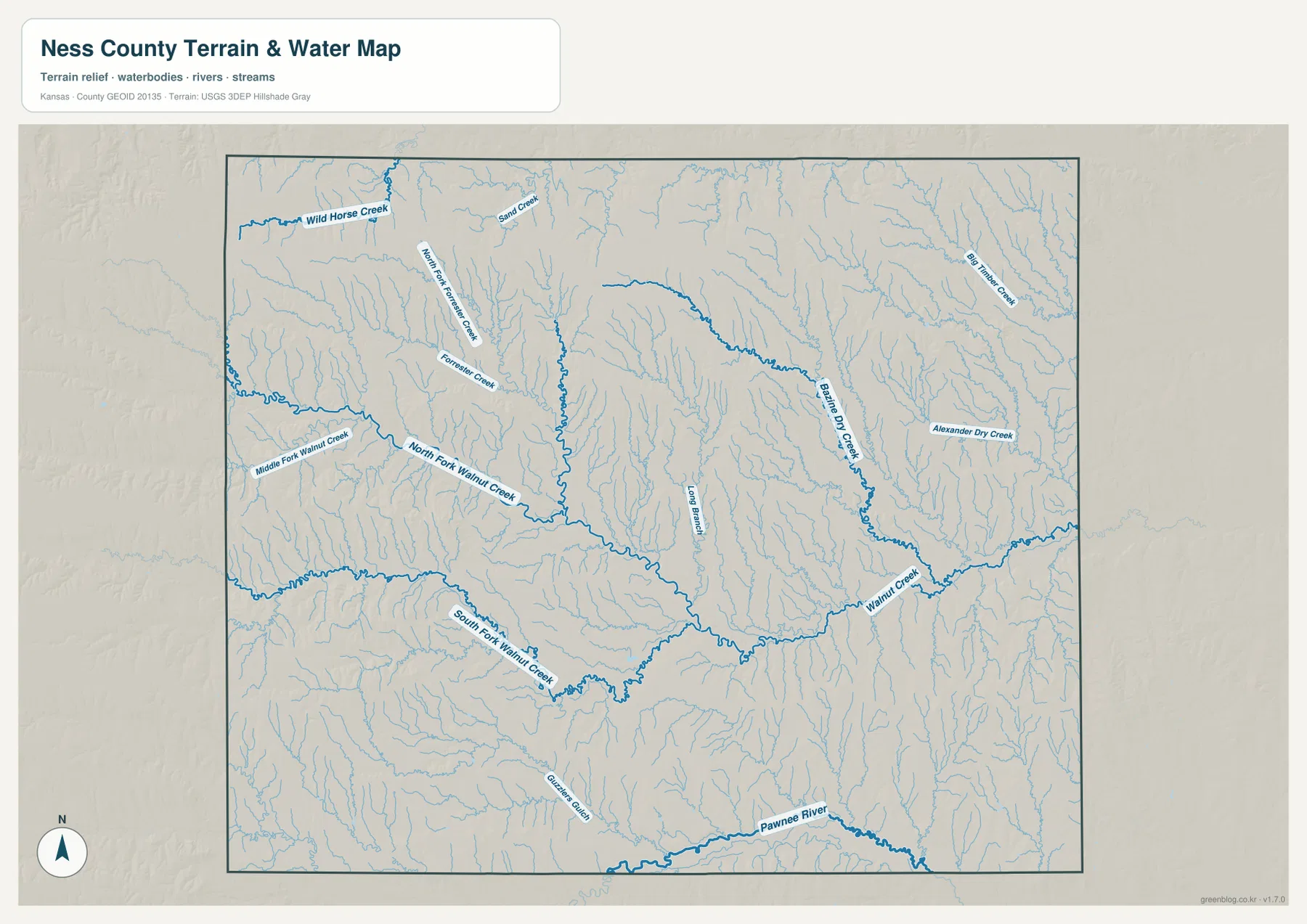
The Pawnee River forms a separate major reference near the southern boundary. Kansas Department of Agriculture watershed material groups Ness County within the Pawnee-Walnut mapping area, which matches the two large drainage systems visible on the supplied map.
This water image is intended for geographic reference rather than floodplain, navigation, water-quality, property, or legal-access decisions. Stream depth and flow can change, and mapped channels do not by themselves establish current access or safety conditions.
Elevation falls from western High Plains uplands toward eastern stream valleys
The elevation surface ranges from about 632 to 819 meters, with a mean near 722 meters. Darker brown terrain dominates much of the west and northwest, while yellow and green colors become more common toward the center and east. The broad county-scale trend is therefore a clear descent from the higher western High Plains toward lower drainage valleys.
Walnut Creek and its forks form long green corridors through the middle and eastern side of the county. Big Timber Creek also connects into lower northeastern terrain, while the Pawnee River creates another low band along the south. Higher ridges remain between these valleys, so the landscape is not a simple smooth slope from one side to the other.
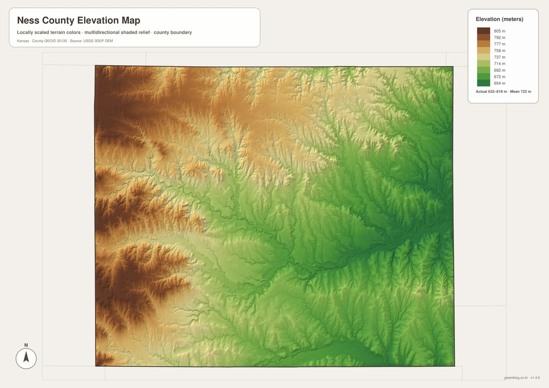
The southwest contains another broad high area, but narrow drainage cuts repeatedly enter it. In the northwest, the upland surface remains high while small tributaries create a fine network of valleys. The east has larger connected low areas, making the contrast between Ness City’s central position and Bazine’s lower creek-side setting easier to see.
The elevation image is generalized for county-scale comparison. It is not survey-grade or engineering-grade measurement and should not be used for parcel elevations, construction grades, drainage design, or legal boundary work.
Ransom and Utica sit among higher northern plains cut by small creeks
Ransom is a useful northern reference because K-4 and US 283 are close to the town. Utica lies to the west along K-4 and Brownell farther east, creating a long, lightly settled corridor across the northern county. North Fork Ransom Creek and Forrester Creek cross the area south of Ransom, while Wild Horse Creek is farther northwest.
The elevation view shows that this northern region is not featureless flat land. High plains are repeatedly cut by narrow stream valleys, and the terrain becomes lower toward Big Timber Creek in the east. The roads appear simple, but the physical landscape beneath them contains many small changes in relief.
East of Ness City, K-96 approaches the lower Walnut Creek country around Bazine
Bazine lies east of Ness City along the K-96 side of the county. Moving in that direction brings the road closer to Walnut Creek and its tributary valleys, where lower green terrain becomes more extensive. Ness City occupies a more central middle-elevation setting, while the Bazine side is more strongly connected to the county’s eastern drainage lowlands.
The Kansas Historical Society records Ness County as established in 1867 and identifies Ness City as the county seat. Combining that historical center with the present road and terrain maps helps explain why Ness City remains the main reference point even though some of the county’s strongest creek valleys lie farther east.
Following one route across the images makes the county easier to understand
For the Ness City-to-Bazine corridor, begin with K-96 and the town locations. Looking at the same stretch on the water image adds Walnut Creek and its tributaries, and the elevation image then shows why those creek corridors are lower than the western uplands. The same place becomes more understandable without needing to memorize a list of map categories.
The Ransom-to-Utica area works the same way. K-4 explains the town spacing, the water image adds North Fork Ransom Creek and Wild Horse Creek, and the relief view reveals the narrow valleys cut into the higher northern plains. The Pawnee River along the southern edge provides a final reference for the county’s other major drainage direction.
For posters, classroom prints, or presentation slides, use the original JPG files in the download archive rather than enlarging the web previews. Small road numbers, creek labels, town names, and the elevation legend remain clearer at the higher resolution.
Frequently Asked Questions
Is Bazine or Ransom closer to Ness City on the supplied city map?
Bazine is shown about 12 direct miles from Ness City, while Ransom is about 13 direct miles away. The difference is small, and actual driving distances can be longer because the map uses straight-line measurements.
Do Walnut Creek and the Pawnee River cross the same part of Ness County?
No. The Walnut Creek system spreads across the central and eastern parts of the county, while the Pawnee River follows the southern edge. They provide two separate drainage references for understanding the county’s low valleys.
Can the 632–819 meter elevation image be used for surveying?
No. It is a generalized county-scale terrain image for comparing the western uplands with lower stream valleys. Parcel elevations, engineering grades, drainage design, and legal boundary work require more precise official data and, where needed, professional surveying.
Map File Information
The archive contains the Ness County, Kansas general county map, city-connections map, terrain-and-water map, and elevation map as original high-resolution JPG files.
- Included Files: Use only the versions confirmed in the article and supplied images
- File Type: Use the confirmed download contents
- Intended Use: Printing, education, presentations, and map-based projects
Related Maps
Sources and references
- Ness County, Kansas official website — county government and local information
- Kansas Tourism: Ness City — Ness City, local history, and visitor context
- Kansas Historical Society: Ness County — county establishment and county-seat information
- Kansas Department of Agriculture: Pawnee-Walnut Watershed — watershed context for Ness County
- U.S. Census Bureau TIGER/Line Shapefiles — county boundary and geographic reference data
- USGS 3D Elevation Program — elevation and terrain reference data
Green Map creates custom-edited map images using open geographic data sources such as geoBoundaries, Natural Earth, OpenStreetMap, and government open data.
These maps are edited visual materials, not raw data files, and are provided for education, documents, presentations, and graphic reference.