Pike County is a small inland county south of the Atlanta metropolitan area, with Zebulon serving as the clearest reference point for roads, public administration, and the locations of the county’s other incorporated towns. The maps on this page show more than a boundary outline: they place Williamson to the north, Concord to the west, Meansville to the southeast, and Molena to the southwest, while also showing the numbered roads, creek network, ponds, and changes in elevation that shape the county between those towns.
The four map images in the article are web-friendly previews. For printing or closer inspection, you can download one ZIP containing four high-resolution A3 JPG files: the county and road map, the city-connections map, the terrain and water map, and the elevation map. The maps are most useful when treated as a set. Roads explain how Zebulon connects to the smaller towns, the water map shows why the spaces between those towns are divided by many creek valleys, and the elevation map makes the higher south-central ridges stand out from the lower western ground.
Pike County was created in 1822, and the present-day map still has a distinctly small-town pattern rather than one large urban center filling the county. That makes relative position especially important. A visitor may know Zebulon by name but not realize how far Molena is toward the southwest corner, how close Meansville is to Zebulon, or how many named creeks and small water bodies cross the countryside. The sections below use the supplied maps to make those relationships clear without treating the page as a technical GIS report.
Table of Contents
Zebulon as the road and county-reference center
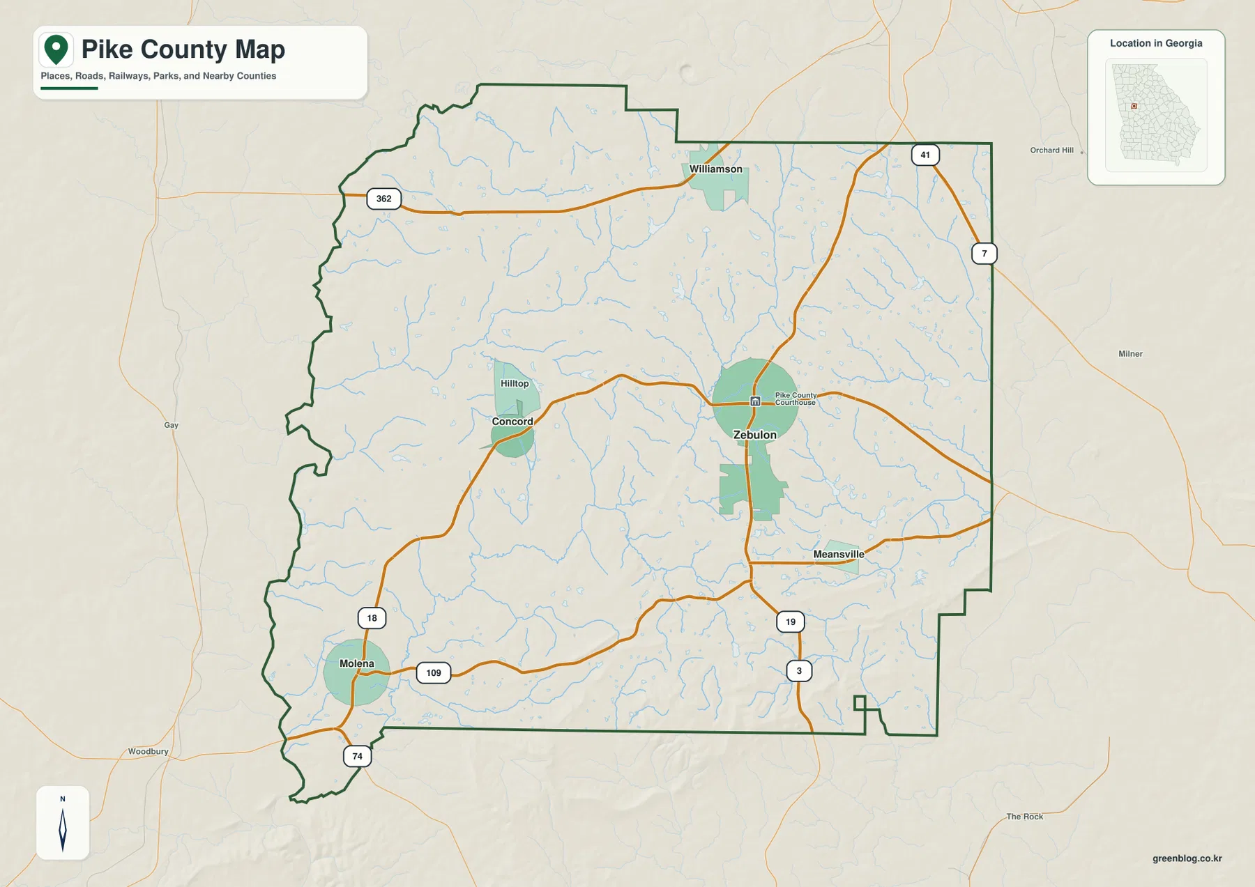
The county map places Zebulon near the middle of Pike County, with the courthouse label immediately beside it. From that central area, several numbered roads lead toward the county’s other towns and outer edges. Williamson sits in the north, Concord lies west of Zebulon, Meansville is southeast of the county seat, and Molena is much farther to the southwest. The boundary is irregular along much of the west side, while long straighter sections appear along parts of the north and east, so the town labels help give the outline a practical sense of direction.
Road 362 crosses the northern part of the county and reaches Williamson, while 41 and 7 appear along the eastern and northeastern side. Through the central area, roads extend west from Zebulon toward Concord and east toward the county line. South of Zebulon, 19 and 3 run downward through the map, and 109 crosses the southern half from the Molena side toward the east. Road 18 appears in the southwest and 74 is marked near the far southwestern corner. Together, these routes show a network that fans out from the county-seat area rather than a single highway corridor controlling the whole county.
This map is best used for orientation, not turn-by-turn driving. It does not show every local street, driveway, parcel line, or unincorporated community, and it should not replace a current navigation service when an exact route matters. Its advantage is clarity: a reader can immediately place Zebulon, compare the directions of the four smaller incorporated towns, and see which numbered roads cross the northern, central, and southern parts of the county.
Five towns spread around Zebulon, with direct distances shown
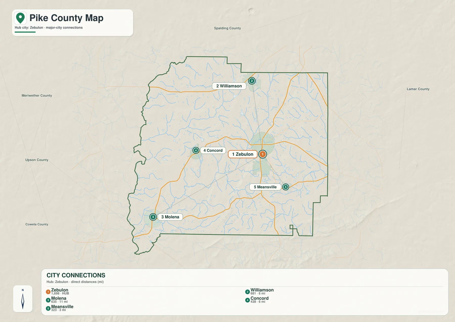
The city-connections map makes the settlement pattern more concrete by using Zebulon as the hub. Williamson is shown about 6 miles north of Zebulon, Concord about 6 miles to the west, Meansville about 3 miles to the southeast, and Molena about 11 miles to the southwest. These are straight-line distances between the mapped town points, not road mileage. A driving route will usually be longer because roads curve, intersect, and do not follow the direct connector line drawn on the map.
Meansville is therefore the closest of the four smaller towns to the county-seat point on this map, while Molena is the most separated. Williamson occupies a distinct northern position near the upper county line, and Concord sits on the western side where the road network leads away from Zebulon. This creates a dispersed pattern: the towns do not form one continuous urban strip. Instead, they are small centers separated by rural land, creek valleys, and local roads, with Zebulon providing the most useful central reference.
The same map labels surrounding counties, which helps explain where each town sits within the larger area. Spalding County is north of Pike County, Lamar County is to the east, and Meriwether County is west. Upson County and Coweta County are labeled around the southwestern side. Williamson’s northern position and Molena’s southwestern position therefore have a different relationship to the county edge than centrally located Zebulon. That context is useful when comparing nearby county maps or explaining where a Pike County town lies relative to neighboring counties.
Creeks, ponds, and the Flint River edge
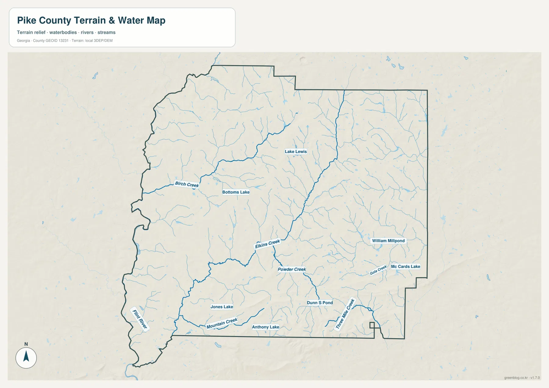
The terrain and water map reveals a county divided by many small streams rather than dominated by one large lake. Birch Creek is labeled across the western side, while Elkins Creek and Powder Creek stand out in the central-southern area. Mountain Creek appears farther south, Three Mile Creek is marked in the southeast, and Gola Creek is labeled toward the eastern side. The Flint River name appears at the far southwest, providing the largest named river reference on the supplied water map.
Several smaller water bodies are labeled between these streams. Bottoms Lake and Lake Lewis lie in the western and central portions of the county, while Jones Lake, Anthony Lake, and Dunns Pond appear across the south. William Millpond and Mc Cards Lake are marked on the eastern side. These are useful local reference points because they show that the land between the towns is not an empty block of countryside. Numerous stream branches and small impoundments break the terrain into short valleys and ridges.
The water map should be read as a geographic reference, not as a flood-risk, parcel, legal-boundary, or boating-navigation product. It shows where mapped water features occur in relation to the county boundary and terrain, but it does not tell a property owner whether a specific site is in a regulated floodplain or whether a water body is publicly accessible. For those questions, the appropriate current agency or property records are necessary. On this page, the map’s purpose is simply to make Pike County’s creek network and named water features easy to locate.
A pronounced high area in south-central Pike County

The elevation map reports an actual county range of about 199 to 386 meters, with a mean near 246 meters. The pattern is not uniform. Much of the western and southwestern area is shown in green, indicating lower ground within the local county scale. Lighter tan and brown ridges become more common toward the center and east, while the darkest and most prominent high area is concentrated in the south-central part of the county.
Smaller ridges also appear in the north and east, but they are less dominant than the high south-central block. When this elevation map is compared with the water map, the reason for the dense stream network becomes easier to visualize. Creeks occupy lower valleys between ridges, while higher ground separates one drainage line from another. Elkins Creek and Powder Creek, for example, can be compared with adjacent lower terrain, and the branching streams around the southern hills show how water routes around and away from higher ground.
This is a generalized county-scale elevation surface designed for visual comparison. It is not survey-grade or engineering-grade elevation data for a construction site, road design, foundation, or precise slope calculation. The color classes and shaded relief simplify the landscape so a reader can see where the county is relatively high or low. For ordinary map use, that is exactly what makes the image helpful: the strong southern high ground and lower western valleys are visible immediately.
How the four maps fit together around Zebulon
Looking at the maps together changes the way Pike County is understood. The county map establishes Zebulon as the administrative and road-reference center. The city map then shows that Meansville is nearby while Williamson, Concord, and especially Molena are separated in different directions. The water map fills the rural spaces between them with named creeks, ponds, and small lakes. Finally, the elevation map explains why that countryside is broken into many small valleys and ridges instead of reading as a completely level surface.
The western side provides a good example. Concord lies west of Zebulon, while Birch Creek and other branches cross the same broad area. Farther southwest, Molena is much farther from the hub point and the Flint River becomes an important water reference near the edge of the county. The elevation map colors much of the western side lower than the prominent south-central hills. A reader using only the road map would miss that physical contrast, while a reader using only the elevation map would not know which town or numbered road occupies each part of the terrain.
The same approach works in the east and south. Meansville is close to Zebulon, but east- and southeast-side creeks and small water bodies create a more detailed landscape than the city dots suggest. South of the county seat, roads 19 and 3 continue through an area that eventually meets higher south-central terrain. Using the maps as companion references therefore gives a more accurate picture of Pike County without crowding one image with every possible layer.
Choosing a Pike County map for roads, water, or terrain
For a first look at Pike County, start with the county map and locate Zebulon, the outer boundary, and the main road numbers. Add the city-connections map when you need to explain how Williamson, Concord, Meansville, and Molena are positioned around the county seat. Switch to the water map when a place name such as Birch Creek, Elkins Creek, Powder Creek, or Flint River matters. Use the elevation map when the question is why southern terrain looks rougher or where the county’s highest and lowest broad areas occur.
- County and road orientation: use the county map for Zebulon, the boundary, and roads such as 362, 41, 18, 109, 19, 3, and 74.
- Town relationships: use the city map to compare directions and straight-line distances from Zebulon.
- Water features: use the terrain and water map for the Flint River, named creeks, lakes, ponds, and millponds.
- Relief and elevation: use the elevation map for the roughly 199–386 meter range and the strong south-central high ground.
If you need the maps for a printed handout, classroom material, a local-history note, or your own document layout, the downloadable files are more useful than the smaller web previews. The ZIP below contains the four original high-resolution A3 JPG maps together, so there is no need to save each preview separately. The JPG files also preserve the map labels at a size better suited to printing and closer inspection.
Frequently Asked Questions
Are the distances from Zebulon driving distances?
No. The city-connections map labels Williamson and Concord at about 6 miles from Zebulon, Meansville at about 3 miles, and Molena at about 11 miles using straight-line distance between the mapped town points. Actual road mileage will usually be longer and depends on the route selected.
Why is the south-central part of Pike County so dark on the elevation map?
That area contains the most prominent high ground on the supplied county-scale elevation map. The map reports an actual range of about 199 to 386 meters and a mean near 246 meters. The darkest brown is a visual class for relatively high terrain within Pike County; it should not be treated as a precise site-survey value.
What is included in the downloadable ZIP?
The ZIP contains four high-resolution A3 JPG files: the county and road map, the city-connections map, the terrain and water map, and the elevation map. They correspond to the four web previews in the article but are better suited to printing and offline use.
Sources and reference links
- U.S. Census Bureau QuickFacts for Pike County, Georgia
- New Georgia Encyclopedia: Pike County
- U.S. Census Bureau TIGER/Line geographic data
- USGS National Hydrography
- USGS 3D Elevation Program
Map File Information
Download the Pike County county, city-connections, terrain and water, and elevation maps together as four high-resolution A3 JPG files in one ZIP archive.
- Included Files: county map, city-connections map, terrain and water map, elevation map
- File Type: four JPG files in a ZIP archive
Related Maps
Green Map creates custom-edited map images using open geographic data sources such as geoBoundaries, Natural Earth, OpenStreetMap, and government open data. These maps are edited visual materials, not raw data files, and are provided for education, documents, presentations, and graphic reference.