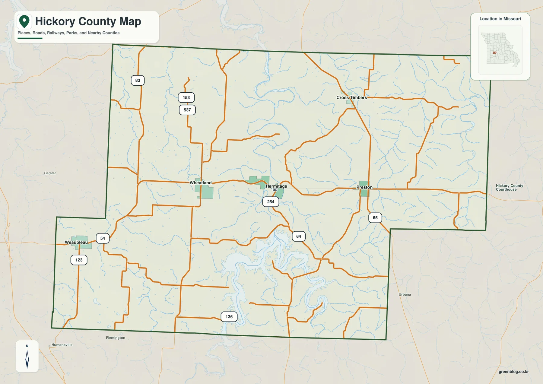
Hickory County lies in the south-central Missouri Ozarks, where Hermitage serves as the main town reference and the Pomme de Terre River system shapes much of the terrain. Wheatland, Weaubleau, Cross Timbers, and Preston are spread around the county rather than forming a continuous urban corridor. The general map highlights Routes 54, 64, 65, 83, 123, and 254, while the terrain-and-water layer shows Pomme de Terre River, Pomme de Terre Lake, Little Niangua River, and many tributaries. The elevation layer gives a mapped range of roughly 215 to 351 meters. High-resolution JPG versions of the same map themes are available together in the ZIP for printing or offline use. High-resolution map files are available for download in the section below.
The county is easiest to understand by starting with Hermitage and then following the river valleys outward. Wheatland lies to the west, Weaubleau to the southwest, Cross Timbers to the northeast, and Preston to the east. Roads curve through the Ozark hills, and the water and elevation layers explain much of that pattern.
Table of Contents
Start with Hermitage and the main road network
Hermitage is the clearest place on the general county map and sits near the middle of Hickory County. Route 254 passes through the area, with roads extending west toward Wheatland and east toward Preston. Route 64 and Route 65 help orient the southern half near Pomme de Terre Lake, while Routes 54 and 123 are useful around Weaubleau in the southwest.
Routes 83, 153, and 537 appear farther north and northwest, and Cross Timbers provides a northeastern reference. The roads are not laid out like a dense city grid. Many bends reflect the valleys and rolling terrain, so the general map works best for broad orientation rather than current turn-by-turn navigation.
The city layer uses Hermitage as a straight-line distance hub
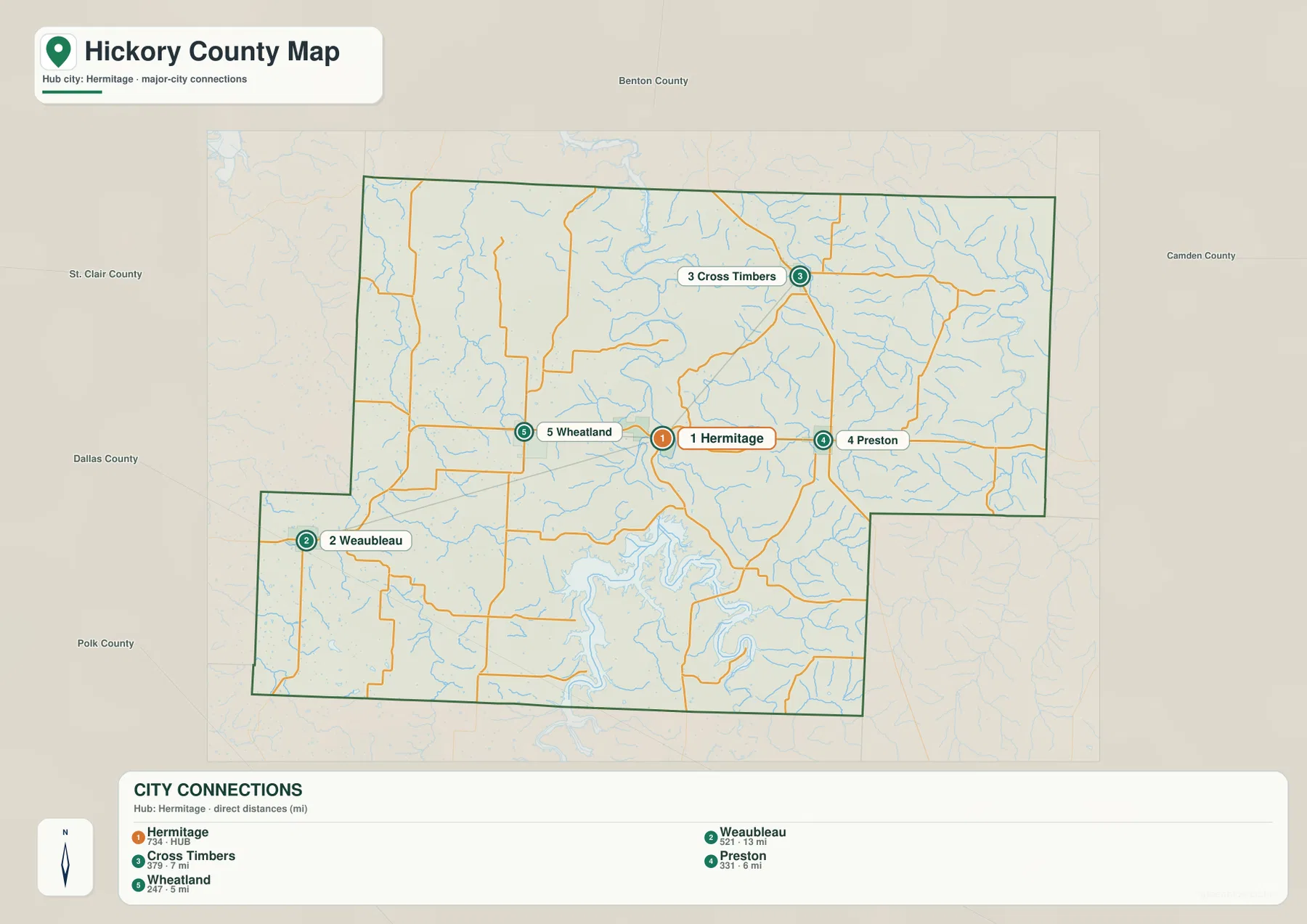
The city map is a connector-distance map rather than a ranked distribution map. Hermitage is marked as the hub, with lines connecting it to Weaubleau, Cross Timbers, Preston, and Wheatland. The legend explicitly describes the values as direct distances, so the connectors are intended to show approximate straight-line separation and direction from Hermitage.
Those values are not driving mileage. Roads in Hickory County curve around hills, streams, and the Pomme de Terre Lake shoreline, so real driving routes can be longer than the direct distance shown on the city layer. The map is most useful for quickly comparing where the smaller towns sit around Hermitage.
Wheatland and Weaubleau anchor the western side
Wheatland lies west of Hermitage and is one of the closest major places on the connector map. Weaubleau sits farther southwest near Routes 54 and 123. The western half contains many short creeks and rolling ridges, so the road network becomes more irregular away from the main corridors.
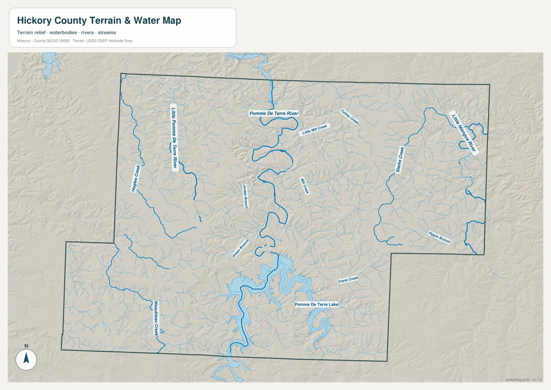
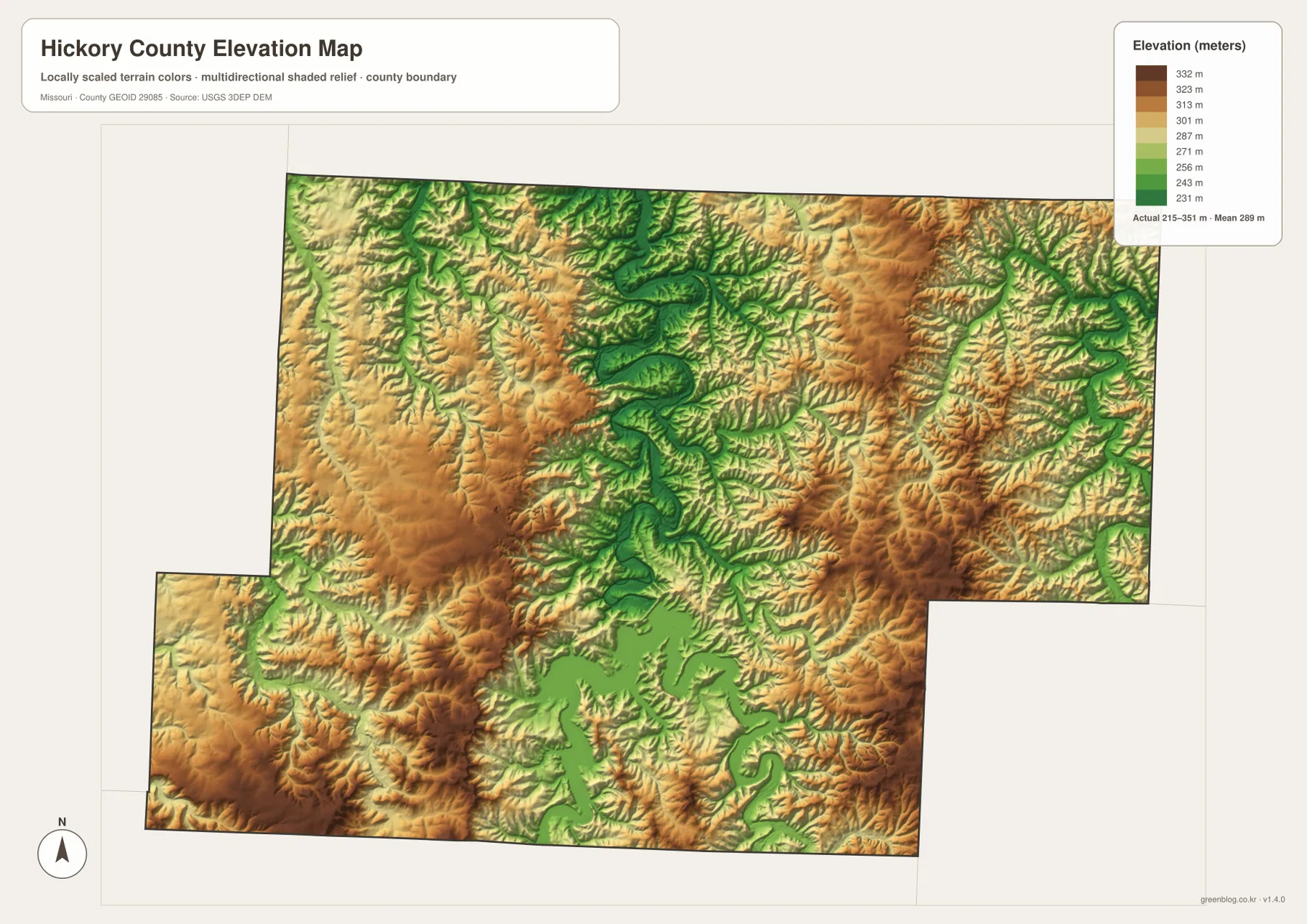
Weaubleau Creek is a prominent named stream in the southwest, while additional tributaries cross the western uplands. On the elevation map, the west and southwest contain broad tan and brown areas separated by narrow green valleys. Comparing the road map with the elevation layer helps explain why local routes rarely follow long straight lines.
Pomme de Terre River forms the central valley
Pomme de Terre River is the dominant watercourse in the county. It enters the north-central area, bends repeatedly through the interior, and continues toward Pomme de Terre Lake. Numerous small tributaries join the river, creating a wide drainage system rather than a single isolated channel.
Little Mill Creek and Jordan Branch are among the smaller named waterways near the central river corridor, while Little Pomme de Terre River creates a separate valley farther west. On the elevation map, the main river follows a long green lowland bordered by higher tan and brown ridges.
Pomme de Terre Lake dominates the southern landscape
Pomme de Terre Lake occupies a large part of the southern interior and extends into many narrow arms and flooded valleys. The shoreline is highly irregular because the reservoir fills a deeply dissected Ozark landscape. Roads around the lake bend between coves, ridges, and tributary valleys rather than following a simple shoreline loop.
Missouri State Parks describes Pomme de Terre State Park as occupying both the Hermitage and Pittsburg sides of the lake. Its official background explains that the Pomme de Terre River was transformed into the reservoir in the early 1960s and describes the surrounding Springfield Plateau as a mix of rolling plains, forests, rugged hills, and river drainages.
Little Niangua River defines the eastern drainage
Little Niangua River appears along the eastern and northeastern side of Hickory County. Starks Creek runs through the east-central interior, while Pippin Branch and Crane Creek provide smaller references farther south. These waterways belong to a different part of the county than the central Pomme de Terre drainage and help organize the eastern landscape.
The eastern side also shows strong local relief. Little Niangua River occupies lower green terrain while nearby ridges rise sharply into tan and brown. The terrain-and-water map is intended for geographic reference; current river levels, flood conditions, legal boundaries, and boating rules should be checked through appropriate official sources.
Elevation ranges from about 215 to 351 meters
The elevation map reports an actual mapped range of approximately 215 to 351 meters, with a mean near 289 meters. The lowest terrain follows the Pomme de Terre River, Pomme de Terre Lake, Little Niangua River, and other major drainage corridors. Higher ridges occupy the spaces between those valleys and appear in tan, orange, and brown.
The central river valley creates a strong north-south low corridor, while the west and east both contain extensive higher ground. Around Pomme de Terre Lake, submerged valleys create a broad low area with many narrow arms. The map is suitable for county-scale terrain comparison but should not be treated as survey-grade or engineering-grade elevation data.
Hermitage and Pomme de Terre State Park connect town and terrain
Hermitage is not only the county’s main map reference but also one of the two sides of Pomme de Terre State Park described by Missouri State Parks. Starting at Hermitage on the road map and moving south toward the lake provides a simple way to connect town, roads, shoreline, and terrain.
The park setting is more than a flat lakeshore. Official park information describes rugged hills cut by river drainages within the Springfield Plateau. That description matches the elevation map, where the reservoir lies in low green terrain surrounded by branching ridges and valleys.
County services and local information are centered in Hermitage
The Missouri Association of Counties lists Hickory County offices such as the presiding commissioner, county clerk, recorder, assessor, collector, treasurer, and sheriff at Hermitage addresses. That makes Hermitage a practical administrative reference as well as the central town on the map.
University of Missouri Extension also maintains its Hickory County office in Hermitage on U.S. Highway 54. Readers looking for current agriculture, 4-H, and community resources can use the map for location context and then consult the official Extension page for current contacts and hours.
Choosing the right downloadable map
Use the general county map for towns and roads. The city connections map is best for comparing the direction and straight-line separation of Weaubleau, Cross Timbers, Preston, and Wheatland from Hermitage. The terrain-and-water map is the clearest choice for Pomme de Terre River, Pomme de Terre Lake, Little Niangua River, and named creeks, while the elevation layer shows the contrast between low valleys and higher ridges.
The download ZIP contains high-resolution JPG versions of the same map themes shown on the page. They are useful for enlarging labels, printing a reference sheet, or comparing layers side by side. The files are intended for general geographic reference and do not replace live navigation, flood warnings, legal surveys, or professional elevation measurements.
Frequently Asked Questions
What is the easiest place to use as a reference in Hickory County?
Hermitage is the clearest starting point. It sits near the middle of the county and provides a convenient reference for Wheatland, Weaubleau, Cross Timbers, Preston, and the Pomme de Terre Lake area.
Are the distances on the city connections map driving distances?
No. The city layer uses direct, straight-line distances from Hermitage. Actual road mileage can be longer because routes curve through Ozark hills, river valleys, and around the lake.
What elevation range does the Hickory County map show?
The elevation layer shows an actual range of about 215 to 351 meters, with a mean near 289 meters. River and reservoir valleys are lower, while the surrounding Ozark ridges rise higher.
Map File Information
Download the map files associated with this page for reference, printing, and compatible visual projects.
- Included Files: Use only the versions confirmed in the article and supplied images
- File Type: Use the confirmed download contents
- Intended Use: Printing, education, presentations, and map-based projects
Related Maps
Sources and references
- Missouri Association of Counties – Hickory County – county offices and Hermitage contact information
- Missouri State Parks – Pomme de Terre State Park – lake history and Ozark terrain context
- University of Missouri Extension – Hickory County – Hermitage county office and local programs
- U.S. Census Bureau TIGER/Line Shapefiles – county boundary and road data
- USGS National Hydrography – rivers, streams, and water features
- USGS 3D Elevation Program – elevation data
Green Map creates custom-edited map images using open geographic data sources such as geoBoundaries, Natural Earth, OpenStreetMap, and government open data. These maps are edited visual materials, not raw data files, and are provided for education, documents, presentations, and graphic reference.