Crawford County sits in west-central Iowa, with Denison serving as the easiest reference point for understanding its roads, towns, river valleys, and rolling uplands. On the standard map, U.S. 30 approaches Denison from the southwest, while U.S. 59 and Iowa 39 help establish the north-south pattern through the central part of the county. Schleswig and Kiron lie to the north, Charter Oak is to the west, Vail and Westside are to the east, and Dow City and Manilla sit farther south. This page uses the supplied standard, city, terrain-and-water, and elevation maps to explain that geography, and the same map themes are available below as high-resolution JPG files in a downloadable ZIP archive.
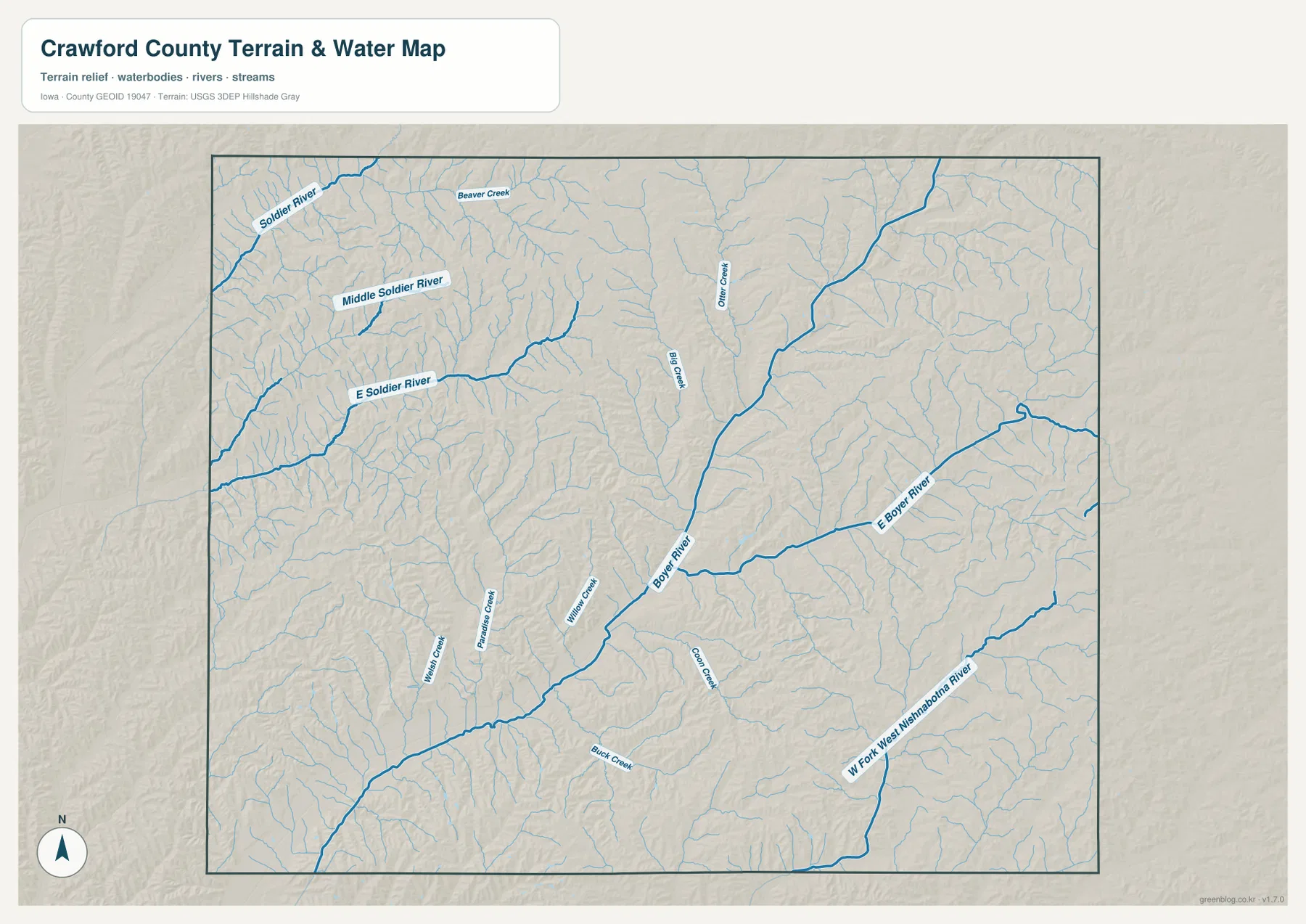
The county becomes much easier to understand when the river network is compared with the road map. The Soldier River system occupies the northwest, with the Middle Soldier River and East Soldier River cutting separate valleys through the hills. The Boyer River forms the major central corridor, while the West Fork West Nishnabotna River creates another low valley in the southeast. On the elevation map, those watercourses appear as long green lowlands separated by tan and brown ridges. Instead of a single flat surface, Crawford County is shown as a deeply dissected landscape where roads and communities occupy a pattern of valleys, slopes, and higher ground.
Table of Contents
Use Denison and U.S. 30 to establish the county’s road pattern
Denison is the most useful starting point on the standard map. It appears slightly south of the county’s center and is surrounded by more labeled roads and local features than the smaller communities. U.S. 30 enters from the southwest through the Dow City and Arion direction, reaches Denison, and then continues toward Vail and Westside on the eastern side. Following that one highway gives a simple west-to-east reference before adding the rest of the road network. For a first look at Crawford County, locating Denison and tracing U.S. 30 is usually easier than trying to interpret every local road at once.
North-south travel is easier to understand after that first reference is in place. U.S. 59 is shown coming down from the Schleswig area, while Iowa 39 follows the Kiron-Deloit side toward Denison. Iowa 141 serves the Charter Oak side in the west, and Iowa 37 appears near the southwestern county edge. These routes help explain why several communities are spread in different directions around Denison rather than forming one continuous urban corridor. The map is intended for geographic orientation, not live navigation, so current closures, construction, and turn-by-turn routing should still be checked with an up-to-date road service.
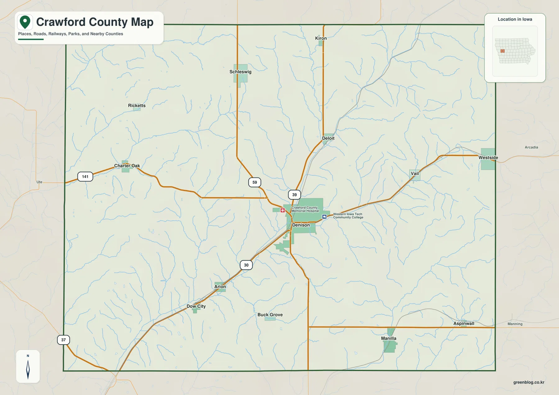
The county boundary also helps make the spacing of the communities clearer. Labels are relatively concentrated around Denison, but the northern and western parts of the county contain smaller towns separated by wider rural areas and numerous creeks. Charter Oak, Schleswig, Vail, Dow City, and Manilla form useful directional references around Denison. The boundary on this map is a general county outline for orientation; it is not a parcel, ownership, legal survey, or engineering boundary and should not be used for a decision that depends on exact property lines.
Six major communities show how settlement is spread across the county
The city map emphasizes Denison, Schleswig, Manilla, Charter Oak, Vail, and Dow City. Denison has by far the largest symbol and occupies the south-central portion of the county. Schleswig sits to the north, Charter Oak to the west, Vail to the east, and Dow City and Manilla to the south. That distribution makes an important point: Crawford County is not organized around a single continuous strip of development. Instead, a larger county seat is surrounded by smaller communities that occupy different road and valley corridors.
This simplified view is useful when the standard map feels busy. Learn the relative position of the six labeled cities first, then return to the road map to see which highways connect them. Deloit, Kiron, Westside, Arion, Buck Grove, Aspinwall, and other smaller places remain useful references on the standard map even though they are not part of the six-city ranking. The two maps therefore answer different practical questions: one makes the main settlement pattern easy to memorize, while the other restores the road detail needed to place those communities in the wider county.
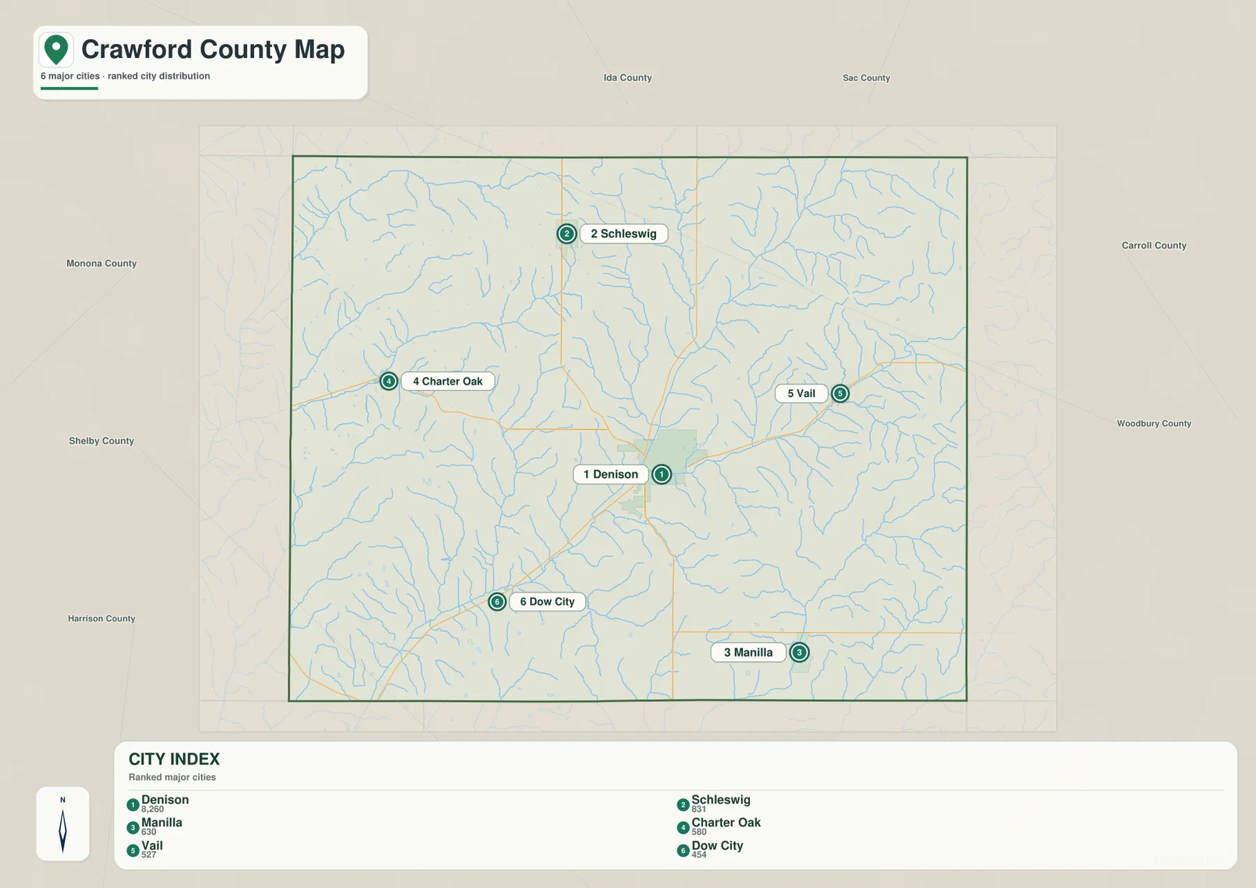
Neighboring county names around the outside of the map add regional orientation, but the most useful information remains inside the Crawford County boundary. Denison works as the main center, while the other cities show how settlement reaches toward the north, west, east, and south. Actual driving distance and travel time can vary with route choice and road conditions, so the city map should be treated as a location guide rather than a mileage or travel-time map.
The Soldier and Boyer systems divide the county into distinct river valleys
The terrain-and-water map shows a strong contrast between the northwestern drainage and the central river corridor. In the northwest, the Soldier River runs through a broad valley, while the Middle Soldier River and East Soldier River occupy separate branches farther south and east. Beaver Creek and many smaller tributaries cut into the surrounding hills. This part of the county looks very different from the standard road map because the land is revealed as a dense network of narrow valleys rather than a simple field of roads and town names.
The Boyer River is the most prominent central feature. It crosses the county on a long southwest-to-northeast course and is joined by a number of tributaries, including the East Boyer River and smaller creeks such as Big Creek, Otter Creek, Willow Creek, Rattlesnake Creek, and Buck Creek. A practical way to read the map is to locate the Boyer first and then trace the smaller streams toward it. That approach makes the drainage pattern easier to understand than trying to follow every thin blue line independently.
The southeast contains another important drainage line: the West Fork West Nishnabotna River. It occupies a separate valley rather than simply continuing the Boyer corridor, which shows that Crawford County is divided among more than one major river system. Comparing the Soldier, Boyer, and Nishnabotna-related valleys is especially useful before looking at elevation, because the lower terrain on the next map follows many of these same waterways very closely.
A 328–474 meter range reveals narrow lowlands between high ridges
The elevation map gives Crawford County an actual displayed range of about 328 to 474 meters, with a mean elevation of 412 meters. The lowest green tones follow the largest rivers and creeks, while tan and brown colors occupy the ridges and uplands between them. The Boyer River creates the clearest central low corridor, running diagonally through the county. The Soldier system in the northwest and the Nishnabotna-related valley in the southeast create additional low routes that match the major waterways on the terrain-and-water map.
Elevation rises quickly away from many of those valleys. Rather than a smooth west-to-east or north-to-south slope, the map shows repeated ridges separated by branching lowlands. Some of the highest terrain lies on broad upland surfaces between the river systems, but high ridges also appear throughout the eastern and southern portions of the county. This broken pattern is one of the strongest reasons to compare the water and elevation maps together: the stream network explains much of the green branching pattern, while the ridges between streams account for the brown, higher terrain.
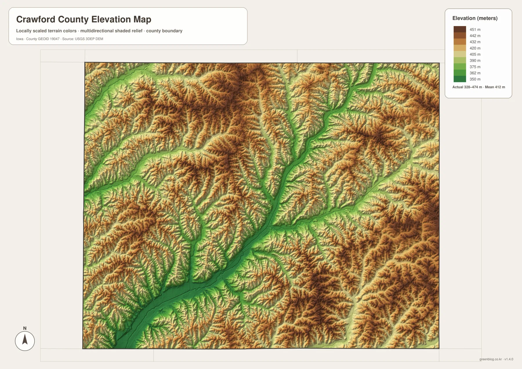
The color surface is designed for county-scale comparison, not exact site measurement. A farm field, building lot, road project, drainage design, or legal survey may require much more precise elevation information than this map provides. Even inside one color band, the ground continues to rise and fall. Use the map to understand the broad relationship between valleys and uplands, then consult original USGS elevation data or a professional survey when a decision depends on a specific height.
Roads and valleys explain why Denison works as the main orientation point
Denison is useful because several map themes come together around it. U.S. 30 reaches the city from the Dow City and Arion direction, while U.S. 59 and Iowa 39 approach the central road network from the north. The water map places the same area among Boyer River tributaries, and the elevation map shows that the city is surrounded by a mixture of lower valleys and higher ridges rather than one broad flat plain. Looking at Denison on all four maps turns it from a single city label into a reference point for transportation and terrain.
Other communities fit into different parts of the valley system. Charter Oak lies toward the western side near the Soldier drainage area, while Dow City sits on the southwest approach to Denison and U.S. 30. Vail and Westside occupy the eastern side where the East Boyer system becomes more important, and Manilla lies farther south near the separate Nishnabotna-related valley. Connecting those city names with the river map helps explain why the county’s communities feel spread out: they are separated not only by distance but also by a repeated pattern of hills and stream corridors.
County conservation information adds real-world context to the Boyer River
Crawford County’s official Conservation page adds useful context to the central river seen on the map. The county says its Conservation Board manages parks, wildlife and forest areas, public hunting areas, and other natural resources, and it specifically notes several public access areas on the Boyer River. That information helps connect the thick blue Boyer line on the water map with places that residents and visitors can actually use for outdoor recreation and access.
The static map should still be separated from current visitor conditions. River levels, park operations, access restrictions, hunting or fishing rules, seasonal closures, and weather-related changes can all vary. Use the maps here for county-wide orientation, then check Crawford County Conservation or the responsible agency for current rules and facility information before visiting a specific site.
Choose the Crawford County map that matches your question
For a first visit to the county, start with Denison and trace U.S. 30, U.S. 59, and Iowa 39. Once those lines are familiar, compare Schleswig, Charter Oak, Vail, Dow City, and Manilla to establish the major settlement directions. If road numbers are distracting and you only need the town pattern, use the city map first; its six emphasized communities make the county layout easier to remember before you return to the standard map.
For water and terrain, begin with the Boyer River, then compare the Soldier River branches in the northwest and the West Fork West Nishnabotna River in the southeast. After those waterways are familiar, switch to the elevation map and look for the green valleys that follow them. The higher ridges between the valleys become much easier to interpret once the drainage pattern is understood. Returning to the standard map after that comparison shows how towns and roads fit within the same terrain.
The WebP images in the article are sized for convenient browser viewing. For printing, classroom work, presentations, or offline reference, use the higher-resolution JPG files in the ZIP below. The archive contains separate standard county, major-city, terrain-and-water, and elevation maps. These are general reference products and do not replace legal boundary records, live road information, flood regulation, property data, or precision surveying.
Frequently Asked Questions
Which map is best for locating Denison and the other major communities?
The major-city map is the simplest choice when you only need the relative locations of Denison, Schleswig, Manilla, Charter Oak, Vail, and Dow City. Use the standard map next if you also want to connect those communities with U.S. 30, U.S. 59, Iowa 39, and other labeled roads.
How can I distinguish the Boyer and Soldier river systems?
The Boyer River is the long central waterway that crosses Crawford County on a southwest-to-northeast course. The Soldier system is concentrated in the northwest, where the Soldier River, Middle Soldier River, and East Soldier River occupy separate branches. The West Fork West Nishnabotna River in the southeast provides a third major reference for comparing the county’s drainage areas.
What does the 328–474 meter elevation range mean on the map?
It is the displayed county-scale range used to compare lower valleys with higher ridges. Green areas follow many of the major rivers and creeks, while tan and brown areas mark higher uplands between them. The map gives a mean elevation of 412 meters, but it should not be used as a precise site elevation for engineering, surveying, or property decisions.
Map File Information
Download high-resolution JPG versions of the Crawford County standard map, major-city map, terrain-and-water map, and elevation map in one ZIP archive.
- Included Files: 4 high-resolution JPG maps
Related Maps
Sources and references
These official sources provide county information and background for the boundary, hydrography, and elevation data used for geographic reference. Check the responsible agency’s latest page for changing park access, administrative information, road conditions, or other current details.
- Official Crawford County, Iowa website
- Crawford County Conservation
- U.S. Census Bureau TIGER/Line Shapefiles
- USGS National Hydrography
- USGS 3D Elevation Program
These maps are intended for general geographic orientation. Legal boundaries, property ownership, current road restrictions, flood rules, and precise elevation should be confirmed with current records or data from the responsible authority.
Green Map creates custom-edited map images using open geographic data sources such as geoBoundaries, Natural Earth, OpenStreetMap, and government open data.
These maps are edited visual materials, not raw data files, and are provided for education, documents, presentations, and graphic reference.