Laurens County sits in central Georgia, with Dublin as the clear urban center and a wide ring of smaller towns, roads, streams, and low ridges around it. The four maps on this page are designed to show those relationships from different angles: the general county map places communities and highways inside the boundary, the city map simplifies the settlement pattern, the water map follows the Oconee River and its tributaries, and the elevation map shows how the river corridor sits below the higher ground to the west and northwest. WebP previews are included in the article, and a ZIP containing four high-resolution A3 JPG maps is available for download.
The strongest geographic pattern is the contrast between the Dublin area and the Oconee River corridor. Dublin lies near the center of the county where several major roads meet, while East Dublin appears just to the east. Dudley and Dexter are farther west and southwest, with Cadwell and Rentz toward the lower-left portion of the county. The Oconee River enters from the north-central side, continues through the county, and bends toward the southeastern boundary. On the elevation map, that same river corridor forms a long band of lower ground surrounded by more dissected uplands.
Table of Contents
Dublin at the Center of Roads, Towns, and County Boundaries
The general reference map gives the broadest view of Laurens County. Dublin occupies the central part of the map and is surrounded by a dense group of roads, while the smaller communities are spread across a much larger rural area. US 80 provides the clearest west-to-east line through Dudley and Dublin. South of Dublin, US 441 and US 319 continue toward the lower part of the county, and a number of numbered state routes branch toward the county edges. This makes the map useful for answering a basic orientation question: where is a town located in relation to Dublin and the county boundary?
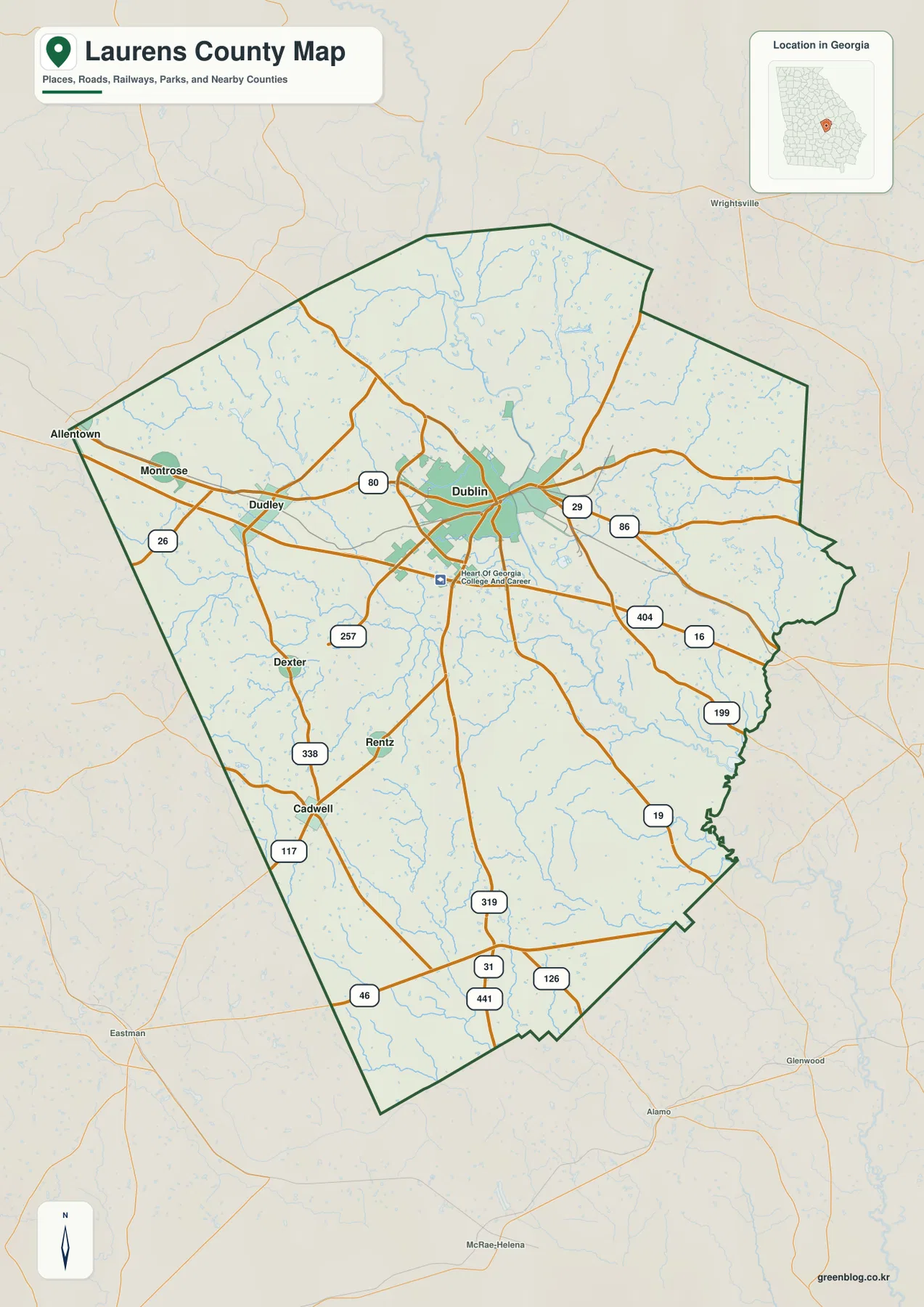
The map also gives context beyond the boundary. Allentown, Wrightsville, Eastman, Glenwood, Alamo, and McRae-Helena appear outside Laurens County, helping place the county within the surrounding part of Georgia. A separate city preview names neighboring counties more directly: Wilkinson County lies to the north, Johnson County to the northeast, Treutlen County to the east, Twiggs County to the southeast, Bleckley County to the southwest, and Wheeler and Dodge counties to the west. Those labels make the page useful for regional orientation even when the reader is not familiar with central Georgia.
Six Mapped Cities Show an Uneven Settlement Pattern
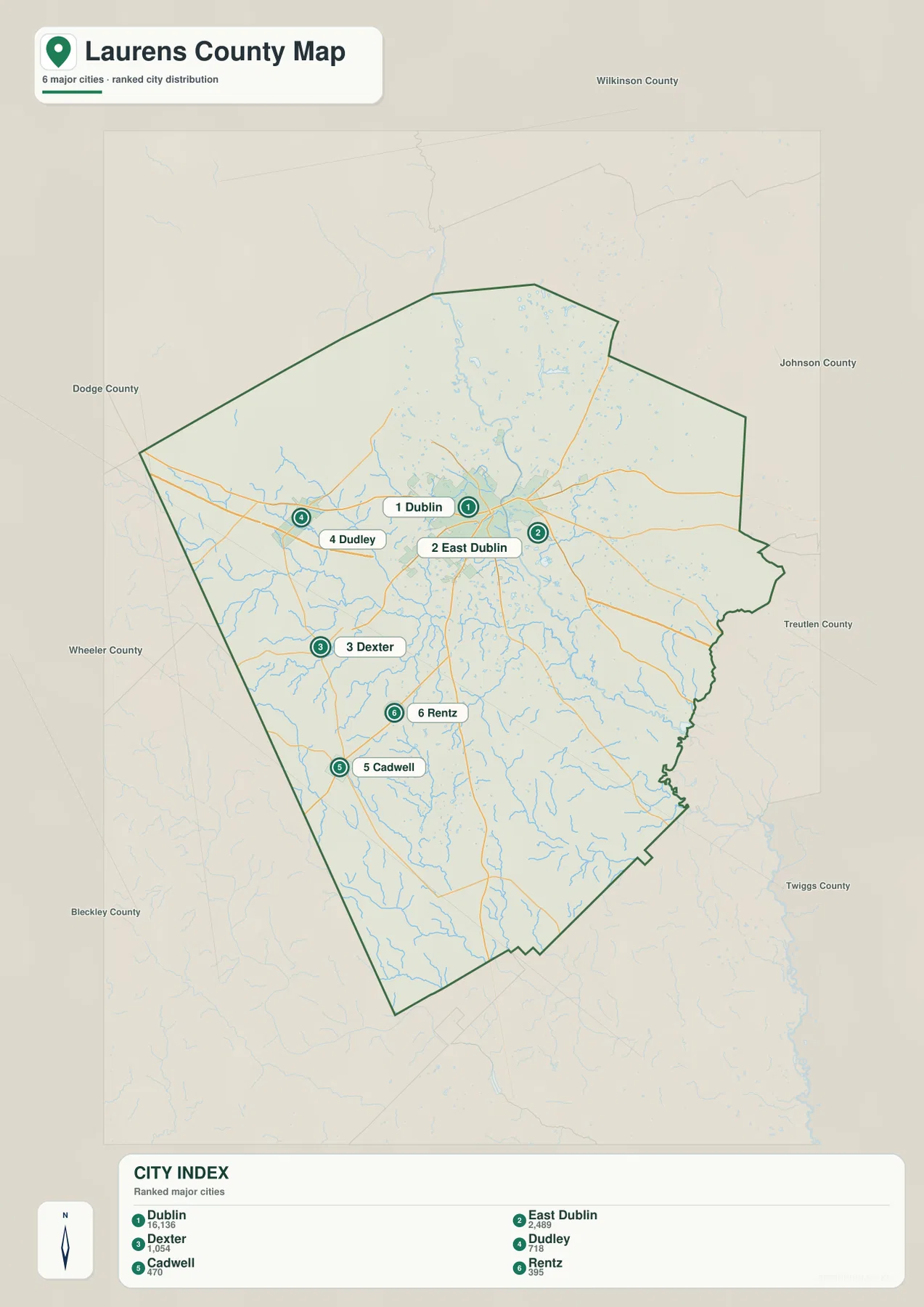
The city map removes much of the visual detail and makes the local settlement pattern easier to compare. Dublin is ranked first, followed by East Dublin, Dexter, Dudley, Cadwell, and Rentz. The city index printed on the preview lists Dublin at 16,136, East Dublin at 2,489, Dexter at 1,054, Dudley at 718, Cadwell at 470, and Rentz at 395. Those figures are presented here as labels from the supplied map rather than as a replacement for current Census estimates. The important visual point is the large difference between Dublin and the smaller incorporated places around it.
Dublin and East Dublin Form the Closest City Pair
Dublin and East Dublin appear close together near the middle of the county, but the map keeps them as separate labeled points. Dublin is the dominant center where several road corridors converge. East Dublin sits just to the east, nearer the Oconee River side of the central area. Dudley is well to the west on the US 80 corridor, Dexter is southwest of Dublin, and Cadwell and Rentz are farther south. Because these communities are not arranged in a simple straight line, the county outline is helpful: without it, the distance between the central city and the southern or western towns is harder to judge.
Waterways Spread Out from the Oconee River Corridor
The water map changes the emphasis completely. The Oconee River is the main feature, entering Laurens County from the north-central side and continuing toward the southeast. A dense network of tributaries feeds into the broader river system from both sides. Rocky Creek and Turkey Creek are prominent in the western half, while Pughes Creek and Whitewater Creek appear on the eastern side. Farther south, Little Stick Creek and Long Branch help show how many smaller valleys cut across the county. The water network is not confined to the Oconee itself; it branches repeatedly across the interior and reaches close to most parts of the county boundary.
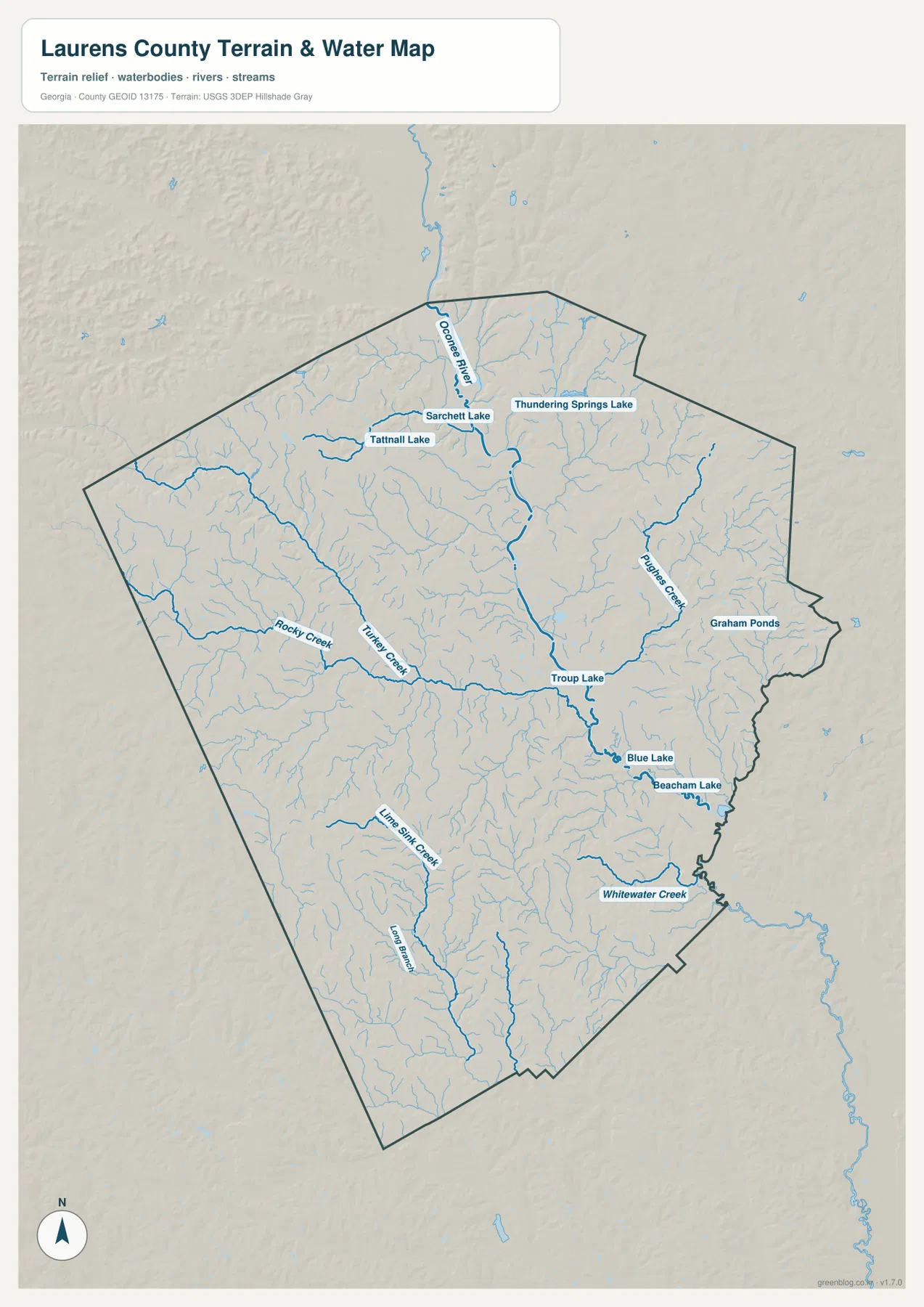
Several named lakes and ponds add useful landmarks. Tatnall Lake, Sarchett Lake, and Thundering Springs Lake are grouped in the northern portion of the map. Troup Lake appears near the central drainage system, with Blue Lake and Beacham Lake farther southeast, while Graham Ponds are labeled near the eastern side. These names are not intended as a complete inventory of every small pond or wetland. Instead, they help the reader recognize where larger or named water features sit relative to the river and the county boundary. For flood risk, property boundaries, boating access, or other site-specific decisions, a specialized and current source would still be necessary.
Elevation Falls into the Oconee River Corridor
The elevation map makes the relationship between water and landform especially clear. Its legend reports an actual elevation range of about 41 to 131 meters, with a mean of 81 meters. The lowest colors form a broad green corridor through the center and southeastern side of the county, closely matching the Oconee River and the larger valleys visible on the water map. Higher browns and tan shades are more common on the western and northwestern sides, where the terrain is more strongly cut by narrow stream valleys and low ridges.
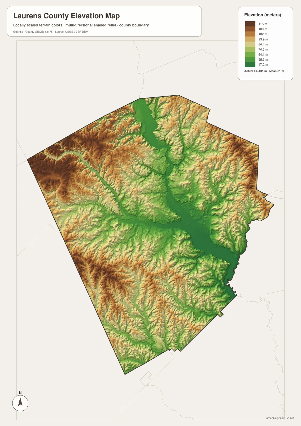
This is not a mountainous landscape, yet the shaded relief shows that Laurens County is far from uniformly flat. Narrow valleys repeatedly cut into the uplands, and the lowest ground follows the major drainage routes. That distinction helps explain why the water map and elevation map work well as a pair: streams occupy the lower channels, while the tan and brown areas rise between them. In the western half, especially toward the northwest, the higher terrain is more continuous. In contrast, the central and southeastern river corridor forms a connected lowland that is easy to trace across the map.
Roads Connect Dublin with the Western and Southern Towns
The road pattern is easiest to understand from Dublin outward. US 80 passes through Dudley before reaching Dublin and then continues toward the eastern side. US 441 and US 319 are visible south of the city and continue toward the county’s lower boundary. Other numbered routes shown on the map include 29, 86, 257, 338, 117, 46, 126, 19, and 199. Together they create a web rather than a single dominant corridor, which is why Dublin appears as the natural meeting point on the general map.
For a visitor, researcher, or student, that road web is useful for comparing place relationships rather than planning a turn-by-turn drive. Dudley is positioned west of Dublin along the same broad east-west route, while Dexter, Cadwell, and Rentz sit on separate routes to the southwest and south. The county map also shows the road network crossing many small streams, reinforcing the connection between transportation and the rolling, drainage-cut terrain. Exact travel times, closures, lane details, and local street access are outside the purpose of these maps and should be checked with a current navigation source.
Choose the Map That Matches the Question
Each preview becomes most useful when it is matched to a specific task. The county map is the best starting point for general orientation because it combines the boundary, roads, place names, and surrounding context. The city map removes much of that detail and makes the six ranked cities easier to compare. The water map is preferable when the Oconee River, tributaries, lakes, and drainage routes are the focus. The elevation map adds the missing vertical dimension, showing where river valleys are low and where the western uplands rise.
- County orientation: compare Dublin, Dudley, Dexter, Cadwell, Rentz, East Dublin, and the county boundary.
- City distribution: see how strongly Dublin dominates the six ranked places and where the smaller towns sit.
- Road reference: follow US 80, US 441, US 319, and the numbered state routes across the county.
- Water reference: trace the Oconee River and named tributaries, lakes, and ponds.
- Terrain reference: compare the 41–131 meter elevation range and the low river corridor with the higher west and northwest.
The WebP images in the article are optimized for quick viewing on the page. If you need files for printing, class work, a report, a presentation, or offline reference, use the ZIP below. It contains four separate A3 high-resolution JPG files: the county map, city map, water map, and elevation map.
Frequently Asked Questions
Why are Dublin and East Dublin shown as separate places?
The supplied city map labels them as two separate city points. Dublin is the much larger central city, while East Dublin appears immediately to its east. The city map is the clearest preview for comparing their positions.
Is the land along the Oconee River lower than most of the county?
Yes. On the elevation preview, the Oconee River corridor is shown as a connected band of lower green terrain through the center and southeast. Higher ground is more common on the western and northwestern sides of Laurens County.
What is included in the downloadable ZIP?
The ZIP contains four A3 high-resolution JPG files: a general county map, a city map, a water map, and an elevation map. The images shown in the article are WebP previews, while the downloadable versions are JPG files intended for easier printing and offline use.
Sources and Reference Data
The maps are general reference products rather than legal boundary, parcel, flood-risk, or navigation documents. The following sources can be used to check county background information or obtain authoritative boundary, hydrography, and elevation data.
- U.S. Census Bureau QuickFacts – Laurens County, Georgia
- New Georgia Encyclopedia – Laurens County
- U.S. Census Bureau TIGER/Line Shapefiles
- USGS National Hydrography
- USGS 3D Elevation Program
Map File Information
Download four A3 high-resolution JPG maps of Laurens County covering the county reference map, city distribution, water features, and elevation.
- File Type: Four A3 high-resolution JPG files in one ZIP
Related Maps
Green Map creates custom-edited map images using open geographic data sources such as geoBoundaries, Natural Earth, OpenStreetMap, and government open data. These maps are edited visual materials, not raw data files, and are provided for education, documents, presentations, and graphic reference.