A Korean version of this map page is available. View Korean Page
A Changhua County map is useful when you need more than a simple location view of central-western Taiwan. Changhua County sits along Taiwan’s west coast, bordered by Taichung City to the north, Nantou County to the east, Yunlin County to the south, and the Taiwan Strait to the west. Because of this position, the county works well as a reference point when explaining central Taiwan’s coastal plain, inland communities, and connections to nearby regions.
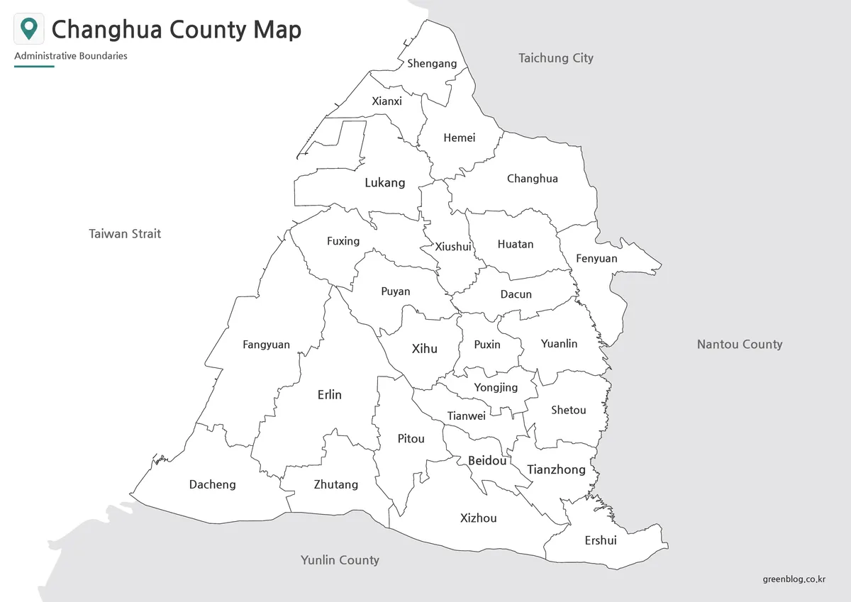
This printable Changhua County map collection includes three versions: a color map, a black and white map, and an outline map. The files are prepared as image files for A3 layout use, making them suitable for classroom handouts, presentation slides, printed documents, blog graphics, and editable visual projects. Instead of focusing only on where Changhua County is located, these maps help users compare the county’s internal administrative areas and understand how places such as Changhua City, Yuanlin City, Lukang Township, Hemei Township, Xihu Township, Tianzhong Township, Beidou Township, and Erlin Township relate to one another.
Changhua County may look compact on a full Taiwan map, but its internal layout is more varied than it first appears. The western side includes coastal and plain areas, while the inland side connects more naturally toward Nantou County and central Taiwan’s interior. The northern part is also closely tied to Taichung, which makes the county useful for regional comparison, commuting context, and presentation materials about central Taiwan.
While preparing this map collection, readability was an important part of the layout. The A3 format was checked so that the county boundary, internal divisions, and labels would not feel overly crowded when printed. The black and white version was also reviewed for document use, where clear line contrast matters more than decorative color. For users who need to add their own marks, the outline version gives a cleaner working base for annotations, route lines, highlighted areas, or classroom coloring activities.
Table of Contents
Changhua County Map Overview
Changhua County is located in the central-western part of Taiwan, facing the Taiwan Strait on the west. Its location makes it useful for explaining the relationship between Taiwan’s coastal settlements and inland regional connections. Taichung City lies to the north, Nantou County to the east, and Yunlin County to the south, so a Changhua County map can also support regional comparison across central Taiwan.
The county includes several important local centers. Changhua City is often used as the main reference point, while Yuanlin City plays an important role in the southeastern part of the county. Lukang Township is well known on the western side and helps show the county’s coastal character. Other areas such as Hemei, Xihu, Tianzhong, Beidou, and Erlin help make the county’s administrative structure clearer when viewed on a labeled map.
For students, teachers, bloggers, and presentation creators, the map is especially helpful because it turns a regional explanation into something visual. Instead of describing the county only in text, users can show where the coastal side, northern connections, and southern townships are located.
Included Map Versions
This collection includes three practical map styles:
- Color map
- Black and white map
- Outline map
Each version has a different purpose. The color map is best for quick visual comparison, the black and white map is better for printing and document use, and the outline map works well when users need a blank base for editing or annotation.
Color Map for Regional Comparison
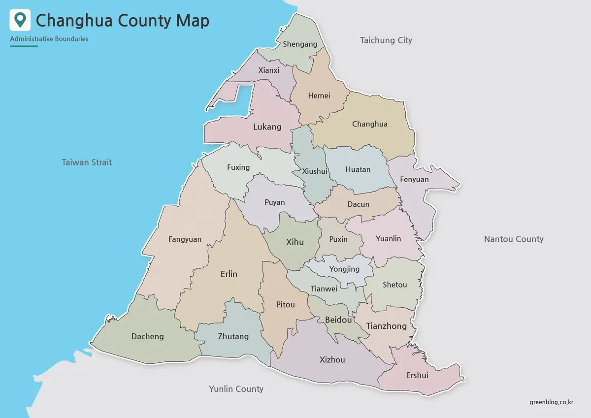
The color version is designed to make Changhua County’s administrative areas easier to compare at a glance. Because the county includes both coastal-side townships and inland communities, color separation helps readers quickly see how the local areas are arranged from north to south and west to east.
This version is useful for presentation slides, classroom explanations, and blog graphics where the viewer needs to understand the county structure quickly. Areas such as Changhua City, Yuanlin City, Lukang Township, Hemei Township, Xihu Township, Beidou Township, Tianzhong Township, and Erlin Township can be compared more easily when the divisions are visually separated.
For a first look at the county, the color map is usually the easiest version to use. It gives enough visual contrast to explain the administrative layout without requiring additional labels or notes.
Black and White Printable Map
The black and white version focuses on labels, boundary lines, and clean document readability. It is useful when color is unnecessary or when the map needs to be inserted into a report, worksheet, printed handout, or simple reference sheet.
Changhua County has enough administrative divisions that a cleaner layout can be helpful, especially when printing in grayscale. The black and white map keeps the emphasis on names and boundaries, making it easier to read alongside written explanations or comparison tables.
This version works well for school assignments, educational materials, and printed map references. It is also suitable for users who want a more neutral visual style for documents or presentation handouts.
Outline Map for Editing and Worksheets
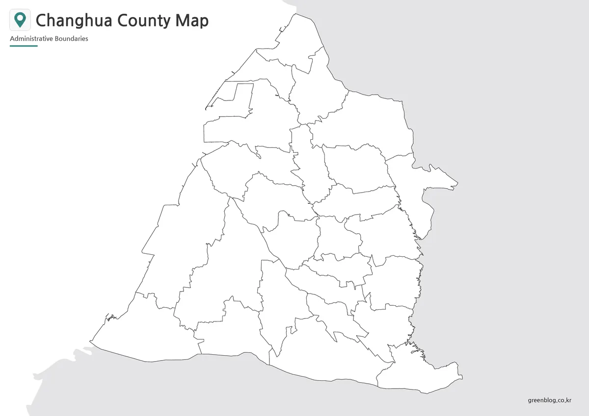
The outline map gives users a blank boundary-based version of Changhua County. It keeps the county shape and internal administrative divisions while removing most visual distractions, making it useful as a working base.
Teachers can use it for coloring activities or regional identification worksheets. Bloggers and designers can use it as a base for infographic projects, travel route marking, local highlight graphics, or simple data visualization. For example, users may want to mark the coastal areas around Lukang, highlight Changhua City and Yuanlin City, or group townships by travel route, population pattern, or regional theme.
Because the layout is simpler, the outline version is also the easiest one to customize. It gives enough structure to show the county clearly while leaving room for added labels, arrows, color blocks, or notes.
Useful Places to Notice on the Map
Several local areas are helpful to remember when reading a Changhua County map.
Changhua City is the main urban reference point and is often used as the starting point for explaining the county. Yuanlin City is important for understanding the southeastern side and the inland living area. Lukang Township helps show the western coastal character of the county and is often useful in travel or cultural context.
Hemei Township is helpful when looking at the northwestern side near the Taichung connection. Xihu Township can be used to understand the southwestern area, while Tianzhong, Beidou, and Erlin help explain the central-southern and southern layout of the county.
These places make the map more useful than a simple outline. They help readers understand how Changhua County functions as a central Taiwan region with both coastal and inland characteristics.
Built for Printing, Presentations, and Graphic Use
The map files are arranged for practical use rather than only visual browsing. The A3 layout gives more room for labels and boundaries, which is helpful when using the map in printed form. For presentation slides, the color version gives quick visual separation, while the black and white version works well when a cleaner and less colorful look is needed.
For editing projects, the outline map can be used as a base layer. It is suitable for adding travel routes, administrative highlights, school notes, regional comparisons, or custom infographic elements. This makes the collection useful for different types of users, including teachers, students, designers, bloggers, and anyone preparing Taiwan-related visual materials.
Frequently Asked Questions
What is included in this Changhua County map collection?
The collection includes a color map, a black and white map, and an outline map of Changhua County.
Can I print the Changhua County map in A3 size?
Yes. The map files are prepared for A3 layout use, making them suitable for classroom handouts, reports, and presentation materials.
Which version should I use for a presentation?
The color map is usually best for presentation slides because it makes the administrative areas easier to compare visually.
Is the outline map good for editing?
Yes. The outline version works well for adding labels, coloring specific areas, marking travel routes, or creating infographic-style graphics.
Can the black and white map be used for school worksheets?
Yes. The black and white version is designed for clean printing and is suitable for worksheets, study materials, and document inserts.
Map File Information
This download includes printable Changhua County map versions for educational use, presentation design, document printing, and editable graphic projects.
- Included Versions: Color map, black and white map, outline map
- Printable Size: A3 layout
- File Type: Image files
- Intended Use: Classroom handouts, presentations, blog graphics, infographic editing, and printable reference materials
Additional Resources
- National Land Surveying and Mapping Center, Taiwan: A useful official map-related resource for checking Taiwan’s geographic and mapping information.
Related Maps
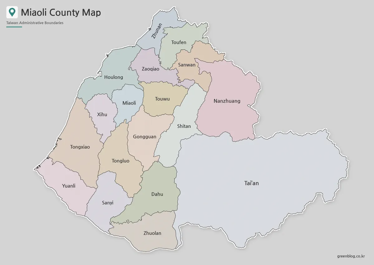
- Printable Miaoli County Map for Education and Design Projects
- Printable Yilan County Map with Administrative Boundaries
- Kaohsiung City Map – Printable District Map Collection
- Taichung City Map for Printing, Editing, and Classroom Use
Green Map creates custom-edited map images using open geographic data sources such as geoBoundaries, Natural Earth, OpenStreetMap, and government open data.
These maps are edited visual materials, not raw data files, and are provided for education, documents, presentations, and graphic reference.