A Mexico Map must accommodate two peninsulas, an expansive north, a densely divided center, and a southeastern land bridge within one wide frame. The supplied collection answers that layout challenge with three matching views: a green labeled map, a black-and-white labeled map, and an unlabeled outline. Each emphasizes federal-entity boundaries rather than roads, relief, municipalities, or tourist destinations.
The country’s long shape creates very different reading conditions. Baja California and Baja California Sur extend down the narrow peninsula in the northwest, while Campeche, Yucatán, and Quintana Roo occupy the peninsula in the east. Between them, large northern entities give way to a compact central cluster where names, points, and leader lines must share limited space.
This Mexico Map set depicts the national top-level framework of 32 federal entities. INEGI currently counts 32 entities, including Ciudad de México, but the two labeled images also retain a separate “Distrito Federal” callout beside “Ciudad de México.” Distrito Federal is the former name of the same capital entity, not a thirty-third current division, so readers should treat that extra callout as legacy wording in the artwork.
The three WebP previews use landscape proportions. The green and black-and-white files measure 1,200 × 844 pixels; the outline measures 1,200 × 847 pixels. Those dimensions support screen use, slides, and many document placements, but they do not establish print quality at every large size. Users should inspect the files inside the protected ZIP before committing to a large-format print run.
Table of Contents
Reading Mexico from Northwest to Southeast
Mexico occupies the southern portion of North America. The United States meets it along the north, while Guatemala and Belize meet it in the southeast. The artwork does not print those country names or label the surrounding seas; instead, gray neighboring land and open or pale-blue water create geographic context around the national outline.
Across the northern mainland, Sonora, Chihuahua, Coahuila, Nuevo León, and Tamaulipas form most of the U.S.-border sequence; Baja California completes the group on the peninsula. Their large shapes contrast with Aguascalientes, Tlaxcala, Morelos, Querétaro, and the capital area. A Mexico Map therefore cannot use one label size and placement method equally well across the whole country.
The southern half narrows toward the Isthmus of Tehuantepec before widening again around the Yucatán Peninsula. Oaxaca and Chiapas occupy much of the south, Veracruz follows the Gulf-facing side, and Tabasco and Campeche lead into Yucatán and Quintana Roo. The supplied boundaries show this sequence clearly even though coastlines, gulfs, and neighboring nations are not named.
Administrative Structure Shown on the Mexico Map
Mexico’s top administrative level comprises 31 states and Ciudad de México. These 32 federal entities are the divisions represented by the internal lines. Municipalities and the territorial demarcations within Ciudad de México sit below that level and are not drawn, so the images are national federal-entity references rather than detailed local-government maps.
Estado de México and Ciudad de México must also be distinguished. Estado de México is a separate state surrounding much of the capital entity, while Ciudad de México is both the national capital and a federal entity. The labeled maps write the state as “Estado de Michoacán de Ocampo” nearby, adding another long name to an already crowded central and west-central zone.
The capital treatment contains a visible historical inconsistency. A red “Ciudad de México” box and star mark the capital, while a black point and leader line identify “Distrito Federal.” Since the 2016 political reform, Ciudad de México is the current name; the old and new labels do not represent separate present-day entities. Anyone using the image in a current lesson should explain or cover the obsolete callout.
Three Map Versions in the Collection
Green Labeled Map
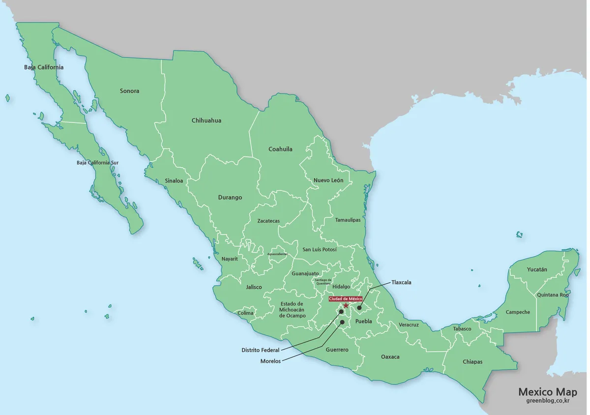
The green Mexico Map uses one shared land color rather than a different color for every entity. White internal borders remain visible across the green field, pale blue surrounds the coastline, and gray pushes adjacent land into the background. This treatment makes the country stand out as a single national unit while preserving the state-level framework.
The green has no thematic meaning. It does not classify climate, population, political results, economic output, or cultural regions. That neutrality suits an opening slide or general orientation graphic, but a data presentation should introduce its own deliberate palette, legend, source, and date rather than treating the decorative green as a category.
Black-and-White Labeled Map
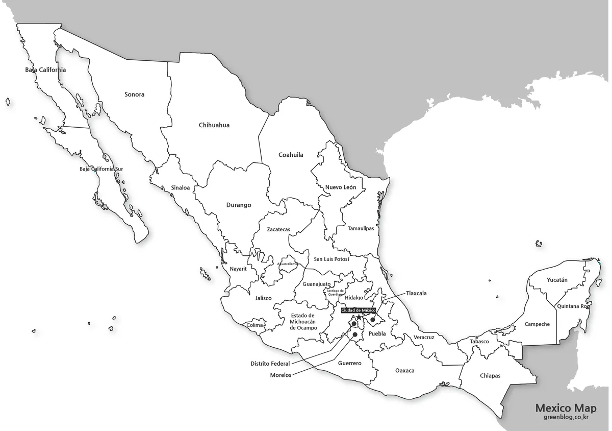
The monochrome Mexico Map removes the green and blue fields, leaving white entity interiors, dark borders, labels, and gray exterior land. A soft shadow still separates the country from its background, so the design is cleaner than the color version but not a bare technical line drawing. It fits documents where the names must remain available without introducing a strong accent color.
Because the interiors are white, readers can circle border states, underline peninsula names, or add a limited set of symbols without covering a colored base. It also works as an answer key beside the blank exercise. The legacy Distrito Federal label remains present, however, so the same current-name caution applies to this version.
Unlabeled Outline Map
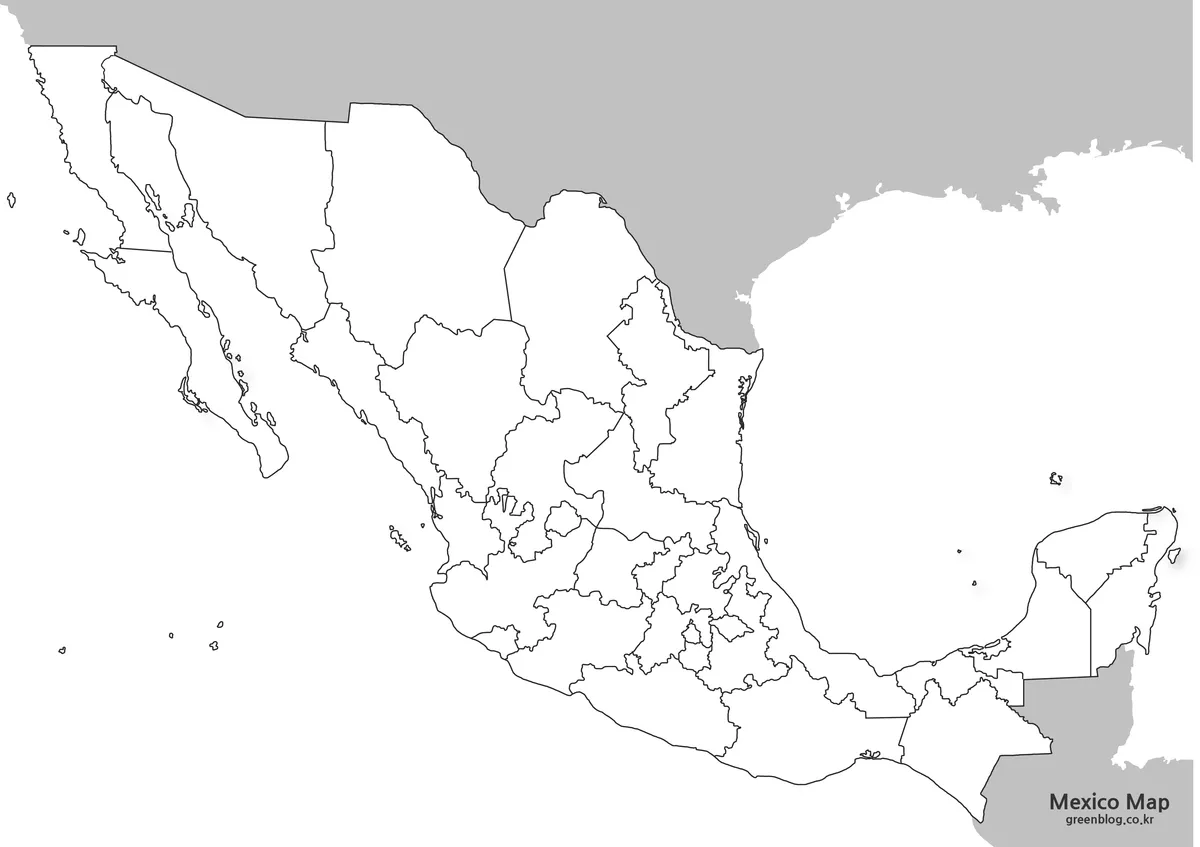
The outline Mexico Map retains the outer coast, island shapes, and federal-entity boundaries while removing every place name, point, and leader line. This is the only version unaffected by the duplicated capital terminology. It offers a clean base for a 32-entity labeling exercise, a border-state activity, or a custom regional grouping.
A geography task can ask learners to label the six states touching the United States, identify the Baja California and Yucatán peninsulas, or locate Chiapas and Quintana Roo at the southeastern international borders. Another exercise can group Pacific-facing and Gulf-facing entities, provided the teacher supplies a separate coastline reference because the surrounding waters are not named.
Designers can add verified statistics, routes, sales regions, or project markers, but the graphic itself supplies no values or categories. New marks should be accompanied by a legend and source date. The WebP is a raster image, not a vector boundary file, GIS layer, or authoritative source for precise measurement.
Choosing a Version for Print or Screen
Choose the green Mexico Map when national shape and internal divisions must register quickly on a screen. Choose black and white for a report, reference sheet, or answer key that still needs Spanish labels. Choose the outline when the reader will provide labels, colors, symbols, or data. None of the three should be selected for road navigation or municipal analysis.
Screen presentations can use the color view as an introduction and switch to the outline for a sourced overlay. In print, the monochrome version reduces competition between the map and nearby text, while the blank view provides the most writing space. For any labeled edition, allocate enough width to preserve the tiny central type and the spacing between leader lines.
Keep an untouched master copy of each image and annotate duplicates. When resizing, lock the proportions so the Baja peninsula does not become too wide and the Yucatán Peninsula does not become too tall. If a project requires current administrative terminology, correct the Distrito Federal callout or use the blank version and add Ciudad de México once.
Practical Geography and Data Activities
A Mexico Map can support a three-stage lesson. Students first read the green image to connect names with shapes, consult the monochrome copy to verify spellings without color cues, and complete the blank outline from memory. Comparing the finished outline with the labeled reference turns the set into a study sequence rather than three unrelated graphics.
For regional comparison, divide the country into questions rather than imposing an unsupported official scheme. Which entities form the northern international border? Which occupy the two peninsulas? Where does the country narrow before reaching Tabasco and the Yucatán Peninsula? These prompts use visible geometry without claiming that the green fill encodes formal regions.
A presentation designer can pair the outline with a table listing values by federal entity. Numbered callouts are preferable in the center when multiple categories would otherwise cover Tlaxcala, Morelos, Ciudad de México, or Querétaro. Large northern areas may accept labels directly, but area size on the map must not be confused with population or importance.
The files omit highways, city networks, municipal boundaries, terrain, scale bars, and coordinates. They are suited to identification, broad administrative comparison, and simple annotation. Travel routes, legal boundary decisions, emergency planning, and precise spatial analysis require a current specialized source rather than this general image collection.
Frequently Asked Questions
What divisions appear on the Mexico Map?
The map shows Mexico’s 32 federal entities at the top administrative level: 31 states and Ciudad de México. Municipal boundaries and the territorial demarcations within Ciudad de México are not shown. Use the collection for national state-level reference rather than local administrative analysis.
Is Distrito Federal the current name for Mexico City?
No. Ciudad de México has been the current name of the federal entity since the 2016 political reform. Distrito Federal is a historical label that still appears in older materials. A current version of the map should use Ciudad de México and avoid presenting both names as separate entities.
Does the green version use colors to classify regions?
No. Mexico is filled with a shared green tone, while white lines distinguish the federal entities. The color does not represent population, climate, political results, or an official regional system. Add a separate legend and verified values if you turn the outline into a thematic map.
Which map should I use for a labeling exercise?
Choose the outline edition because it retains the federal-entity boundaries without names. Students can add entity names, capitals, border-state shading, or peninsula labels. The black-and-white edition is better when a completed name reference needs to remain visible beside the exercise.
Can the supplied images be printed at A3 size?
The attached previews are approximately 1200 pixels wide, which is not enough to promise high-quality A3 output in every printing workflow. Inspect the original files in the downloadable archive before large-format printing. For smaller handouts or slides, preserve the aspect ratio and test the dense central labels first.
The protected ZIP contains the matching green labeled, black-and-white labeled, and blank-outline image versions. Select a version according to whether the project needs immediate orientation, a restrained name reference, or an empty federal-entity base for carefully sourced additions.
Map File Information
The archive provides three matching federal-entity views for reference, labeling practice, slides, reports, and custom annotations.
- Included Versions: Green labeled map · Black-and-white labeled map · Blank outline map
- File Type: Image files in a ZIP archive
- Intended Use: Lessons · reference sheets · presentations · sourced overlays
Related Maps
Additional Resources
- INEGI: Territorial Division of Mexico — Mexico’s national statistics and geography institute explains the current 32 federal entities and the lower administrative levels.
Green Map creates custom-edited map images using open geographic data sources such as geoBoundaries, Natural Earth, OpenStreetMap, and government open data.
These maps are edited visual materials, not raw data files, and are provided for education, documents, presentations, and graphic reference.