An Elko County Map has to cover an unusually broad slice of northeastern Nevada. I-80 links Elko, Carlin, Wells, and West Wendover across the county, while U.S. 93 runs north from Wells toward Jackpot and Idaho. Away from those corridors, mountain ranges divide Owyhee, Humboldt, and Ruby Valley watersheds, and the Ruby Mountains rise sharply above long basin floors. The WebP previews are designed for quick viewing, while the same four maps can be downloaded below as high-resolution JPG files in one ZIP archive. High-resolution map files are available for download in the section below.
The county’s scale is easier to understand when its cities and physical geography are viewed together. Elko and Carlin sit in the western I-80 corridor, Wells lies farther east, and West Wendover reaches the Utah state line. Owyhee, Wildhorse, and Jackpot provide northern reference points, while the Ruby Valley side stretches far south. The road, city, water, and elevation views each reveal a different part of this large basin-and-range landscape.
Table of Contents
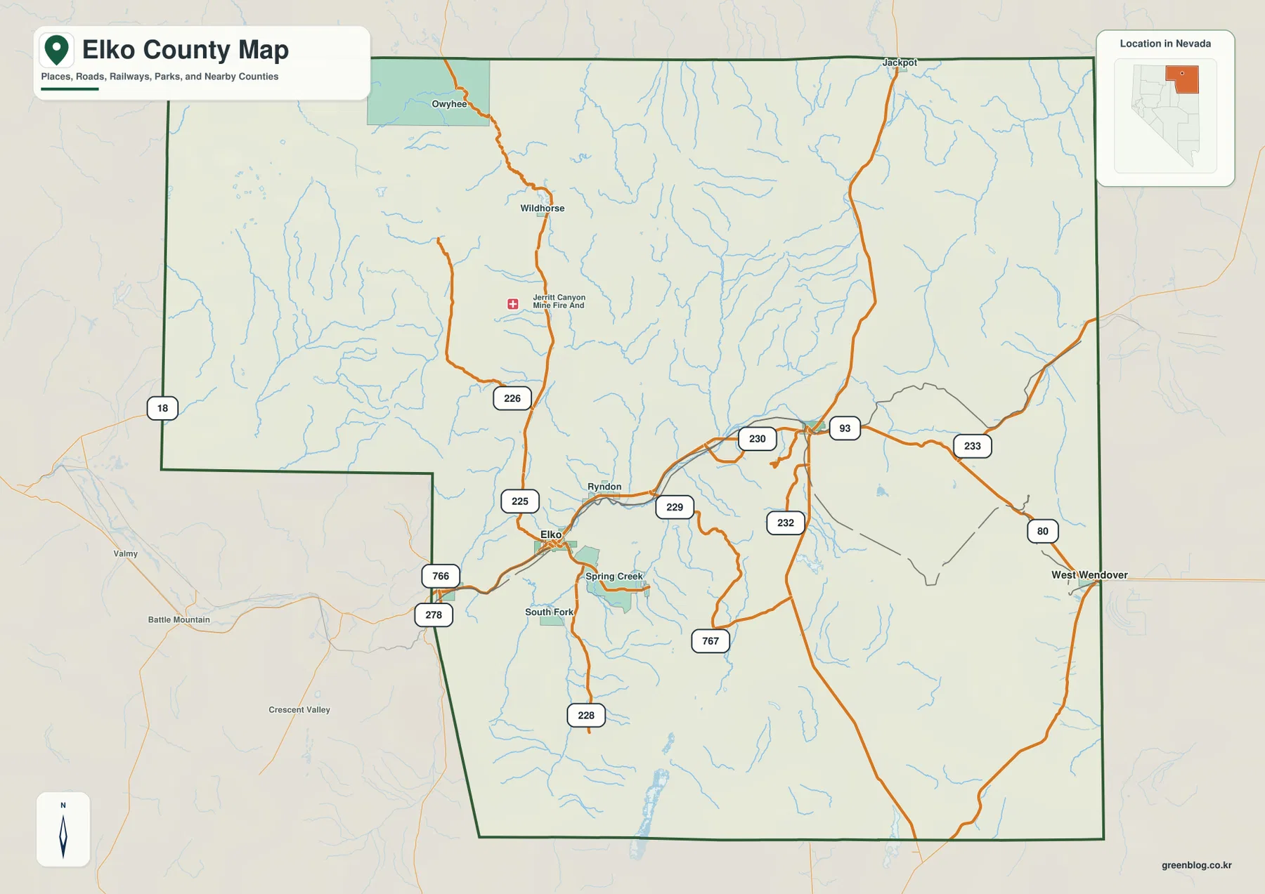
I-80 crosses from Elko and Carlin to Wells and West Wendover
I-80 is the clearest organizing feature on the general county map. It enters from the west near Carlin, passes through Elko, continues east to Wells, and reaches West Wendover at the Utah boundary. Around Elko, Spring Creek and South Fork add nearby settlement references. At Wells, U.S. 93 turns north through the eastern county toward Jackpot, creating the most important north-south highway connection on the map.
Nevada 225 heads north from Elko toward Owyhee, while 226 serves the Wildhorse and Jerritt Canyon side of the northern interior. Routes 229 and 230 provide secondary connections east of Elko, and 232 and 233 serve the Wells and eastern side. In the south, 228 and 767 cross long rural stretches, while 278 and 766 appear near the western boundary. The spacing of these routes reflects a county where ranches, mines, mountain valleys, and small communities are separated by long distances.
Nevada law records that Elko County was created from part of Lander County in 1869 and identifies the City of Elko as the county seat. The Nevada State Historic Preservation Office traces Elko itself to the Central Pacific Railroad in late 1868 and describes its later role as a transportation, ranching, and commercial center for northeastern Nevada. The modern highway corridor follows the same broad east-west geography that made the town important during the railroad era.
This static map is intended for regional orientation rather than live navigation. Winter weather, construction, mining access, and unpaved road conditions can change quickly in remote areas. Its strength is showing how I-80 and U.S. 93 structure travel across the county and how roads branch toward Owyhee, Wildhorse, Ruby Valley, and other widely separated landscapes.
Straight-line city connections reveal the county’s long east-west span
The city-connections panel uses Elko as the hub and links it with Carlin, Wells, and West Wendover. Elko ranks first, followed by West Wendover, Carlin, and Wells. Carlin sits close to Elko along the western I-80 corridor, while Wells and especially West Wendover show how far the county extends toward Utah.
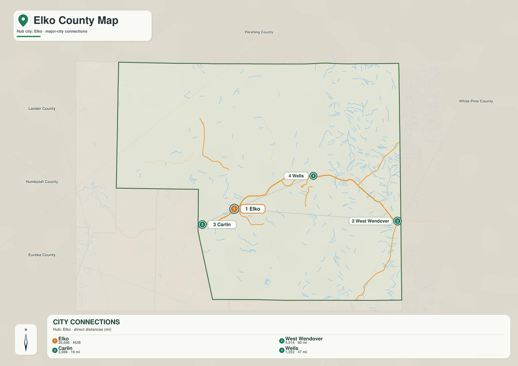
The panel shows about 19 miles from Elko to Carlin, 47 miles to Wells, and 90 miles to West Wendover. These are straight-line distances, not road mileage. Actual driving distance follows I-80 and can be longer. West Wendover’s position at the Utah line makes the 90-mile connection especially useful for visualizing the county’s broad east-west scale.
The panel does not rank every settlement in Elko County. Spring Creek, South Fork, Owyhee, Jackpot, and other named places appear on the broader road map but not in the four-city connection index. Exact current population figures should come from Census or local data; this graphic works best as a spacing and orientation tool.
Owyhee headwaters, Humboldt tributaries, and reservoir country
The terrain-and-water map shows several separate drainage systems rather than one countywide river. In the northwest, South Fork Owyhee River and Willow Creek cross mountain-and-basin country, while Sheep Creek Reservoir, Desert Ranch Reservoir, Wilson Reservoir, and Wild Horse Reservoir form a notable group of named waters. These features occupy a different watershed from the Humboldt system farther south.
West Fork Beaver Creek appears in the north-central interior, while Thousand Springs Creek and Bishop Creek Reservoir mark the northeastern side. These streams descend through long valleys between mountain ranges, emphasizing how frequently divides separate neighboring basins. The water map is especially useful here because road corridors alone do not reveal which direction the separate valleys drain.
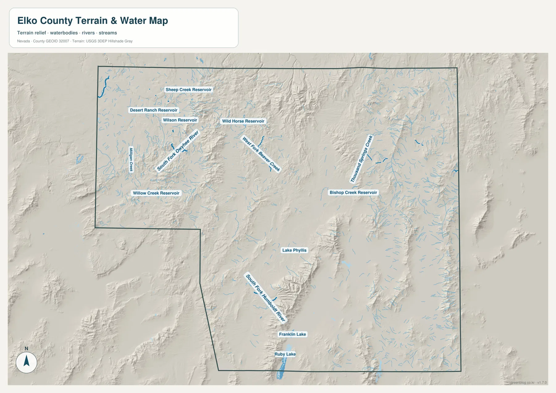
South of the I-80 corridor, South Fork Humboldt River follows lower country beside the Ruby Mountains, while Franklin Lake and Ruby Lake sit farther south. Lake Phyllis appears among the interior ranges. The contrast between northern Owyhee waters and southern Humboldt–Ruby Valley drainage shows why Elko County cannot be described as a single dry basin; multiple mountain watersheds and closed lowlands share the same jurisdiction.
Stream line width and water color are symbolic and do not measure flow, depth, flood hazard, or current reservoir level. Access and water conditions can change by season and management. Use current USGS and managing-agency information for boating, fishing, flood, water-quality, and safety decisions.
Basins near 1,285 meters sit below mountains reaching 3,412 meters
The elevation map makes the county’s basin-and-range structure immediately visible. The displayed surface ranges from about 1,285 to 3,412 meters, with a mean near 1,874 meters. Broad valleys along the western and central transportation corridor appear in green, while narrow brown mountain chains repeatedly rise through the center, north, and south.
The Ruby Mountains southeast of Elko create one of the strongest relief contrasts. A long, high ridge system separates Ruby Valley and the Franklin Lake side from neighboring basins, while several northern ranges rise just as abruptly from lower open country. Around Wells and toward West Wendover, lower corridors continue between isolated ranges, producing the repeating mountain-valley pattern associated with Nevada’s Basin and Range Province.
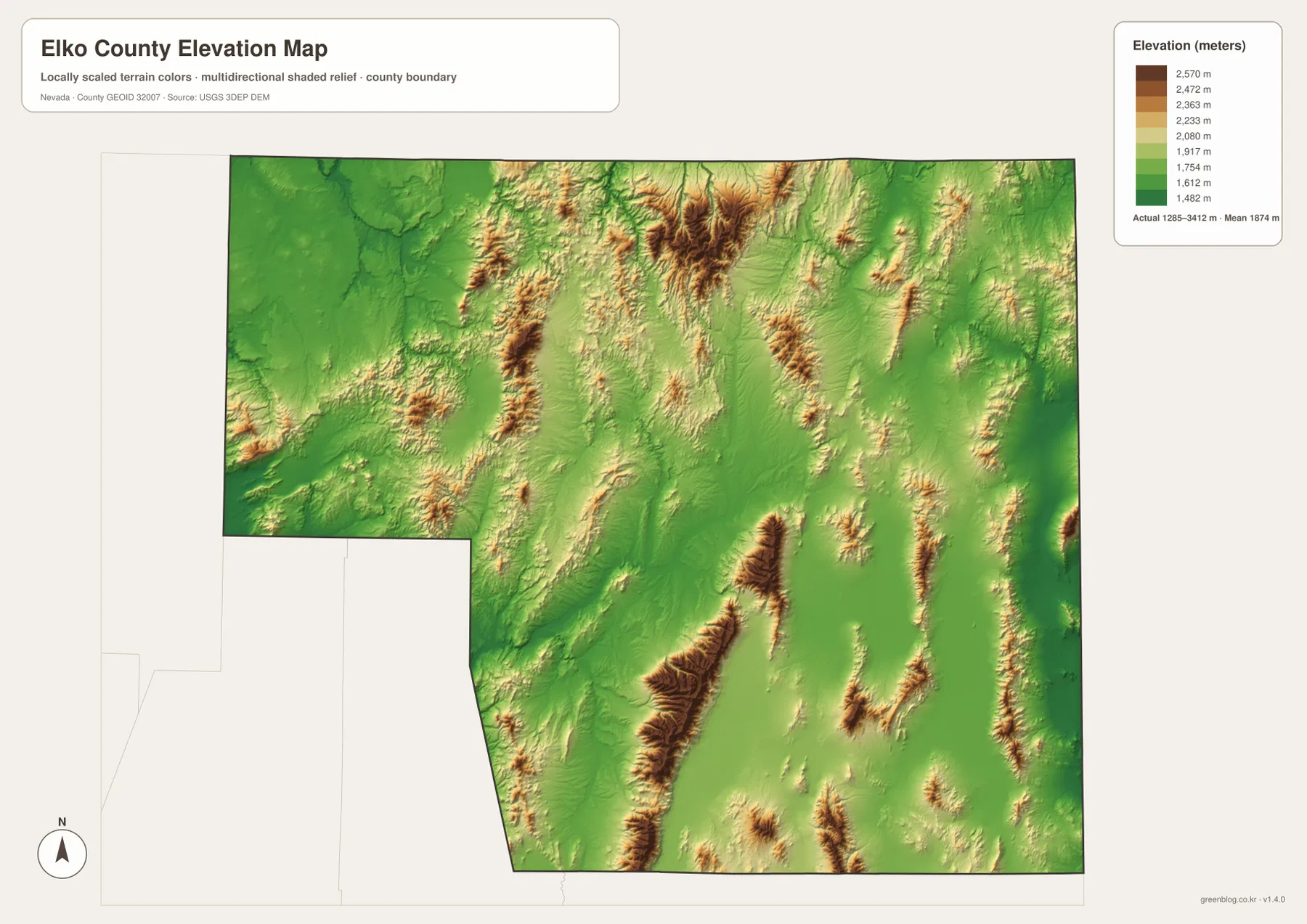
Elko and Carlin sit close to relatively low Humboldt Valley country, but high terrain rises quickly outside the transportation corridor. Wells occupies another basin setting farther east, and West Wendover lies near the Utah line where low valley terrain meets surrounding ranges. The northern Owyhee side looks more open in places, yet the shaded relief still reveals ridges and deeply cut stream valleys.
This elevation surface is intended for county-scale comparison, not surveying or engineering. Exact parcel elevation, mine planning, mountain-road grade, construction benchmarks, and safety decisions require appropriate USGS source data, current field information, or professional surveying.
Ruby Mountains and Lamoille Canyon rise just southeast of Elko
The Ruby Mountains are one of Elko County’s most recognizable natural landmarks. The Elko Convention & Visitors Authority describes the range as a high alpine landscape southeast of Elko, reached most commonly by the Lamoille Canyon Scenic Byway. Glacially shaped valleys, high peaks, alpine lakes, and seasonal snow make the Rubies look very different from the broad sagebrush basins surrounding them.
Lamoille Canyon is approached from the Elko and Spring Creek side of the county, and the visitor authority notes that many Ruby Mountains summits rise above 10,000 feet. Ruby Dome exceeds 11,000 feet and stands among the range’s best-known high points. On the elevation map, the mountain belt southeast of Elko is unmistakable because it rises so sharply above adjacent valleys.
The mountain setting also helps explain Elko’s cultural identity. Nevada’s State Historic Preservation Office describes Elko as a long-standing center for northeastern Nevada ranching and commerce, while modern visitor information connects the city with the Ruby Mountains, western heritage, and outdoor recreation. Seen together, the road and elevation maps show why Elko functions as a gateway between a major interstate corridor and extensive high-country landscapes.
A practical sequence for reading the interstate corridor and mountain watersheds
Begin with the general map by locating Elko, Carlin, Wells, and West Wendover along I-80, then follow U.S. 93 north from Wells toward Jackpot. The city-connections panel adds a simple scale reference by showing straight-line distances from Elko to the three other ranked cities.
For physical geography, compare South Fork Owyhee River and the northern reservoirs with South Fork Humboldt River and Ruby Lake farther south. The elevation map then shows why these watersheds separate: long mountain ranges divide broad valleys, and the Ruby Mountains form one of the county’s largest high barriers.
The high-resolution JPG files are more convenient for printing and for zooming into smaller road, stream, and reservoir labels than the on-page WebP previews. They remain reference maps rather than legal boundary, parcel, flood, navigation, mine-planning, or engineering products. For technical use, compare them with current Census, USGS, and appropriate local or state data.
Frequently Asked Questions
Are the Elko-to-Carlin, Wells, and West Wendover mileages driving distances?
No. The city-connections panel shows straight-line distances of about 19 miles to Carlin, 47 miles to Wells, and 90 miles to West Wendover. Actual driving distances follow I-80 and can be longer.
Where are the Ruby Mountains in relation to Elko?
The Ruby Mountains rise southeast of Elko and extend south through a long high ridge system. Lamoille Canyon provides one of the best-known approaches from the Elko and Spring Creek side, and the elevation map shows the range standing far above adjacent basins.
Can the 1,285–3,412 meter elevation range be used for surveying?
No. Those values describe a generalized county-scale elevation surface. Exact site elevations, road grades, mine or construction benchmarks, and engineering work require appropriate USGS source data or professional surveying.
Map File Information
Download the four high-resolution JPG maps shown on this page for Elko County in one ZIP archive.
- Included Files: Use only the versions confirmed in the article and supplied images
- File Type: Use the confirmed download contents
- Intended Use: Printing, education, presentations, and map-based projects
Related Maps
Sources and references
County creation and the Elko county seat are supported by Nevada Legislature records. Elko’s railroad and ranching history comes from Nevada’s State Historic Preservation Office, while Ruby Mountains and Lamoille Canyon context comes from the Elko Convention & Visitors Authority. The federal sources below provide authoritative boundary, hydrography, and elevation references.
- Nevada Legislature – Elko County Creation and County Seat
- Nevada State Historic Preservation Office – Elko
- Explore Elko – Ruby Mountains and Lamoille Canyon
- U.S. Census Bureau – TIGER/Line Shapefiles
- USGS – National Hydrography
- USGS – 3D Elevation Program
Green Map creates custom-edited map images using open geographic data sources such as geoBoundaries, Natural Earth, OpenStreetMap, and government open data. These maps are edited visual materials, not raw data files, and are provided for education, documents, presentations, and graphic reference.