Grant County occupies a north-south corridor in northern Kentucky where Crittenden, Dry Ridge, Williamstown, and Corinth line up along or near I-75. The maps on this page show that settlement pattern alongside numbered roads, lakes and creeks, and an actual elevation range of about 163 to 305 meters. Four high-resolution JPG map files are also available in one ZIP for printing, classroom use, or closer comparison beyond the screen-sized WebP images.
The quickest way to orient yourself is to find I-75 first. Crittenden sits near the northern edge, Dry Ridge lies farther south, Williamstown follows below it, and Corinth is close to the county’s southern tip. West of that highway corridor, the land opens into broader valleys cut by many small streams, while the central and eastern sections contain a denser pattern of short ridges and narrow hollows. Those differences give the road, water, and elevation layers distinct roles without requiring four separate descriptions of the same landscape.
Table of Contents
I-75 ties together the county’s four clearest settlement references
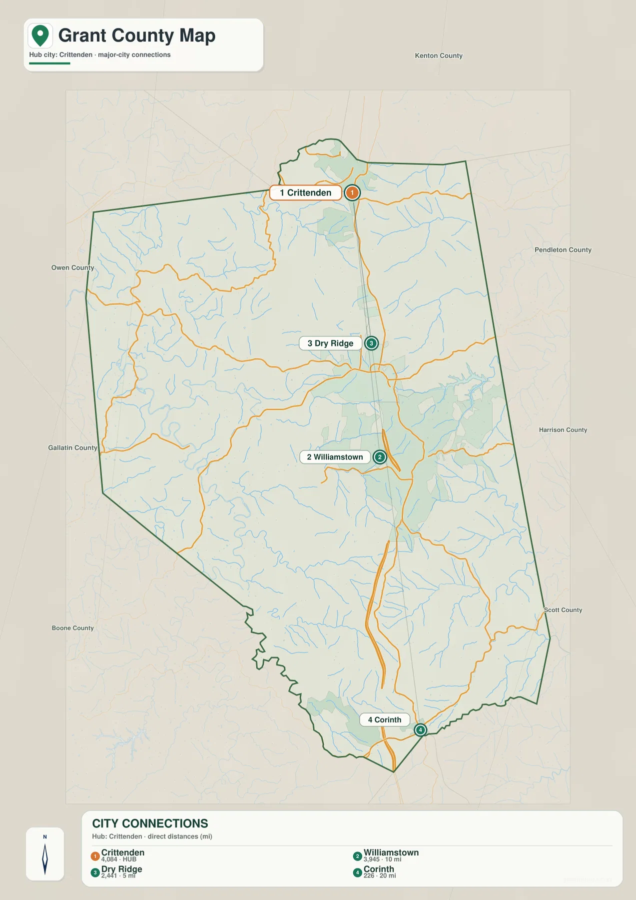
The general county map makes I-75 the strongest visual line. It enters near Crittenden, passes Dry Ridge, runs just east of Williamstown, and continues toward Corinth before leaving the county. KY 491 and KY 467 add east-west access in the northern and western sections, while KY 22 crosses the western half and KY 36 serves the east. Farther south, U.S. 25 and KY 330 and 607 provide additional local references around the Corinth area. Using the interstate first and then branching to the numbered routes is an efficient way to locate smaller places inside the boundary.
The settlement pattern is notably uneven. Crittenden, Dry Ridge, and Williamstown form a relatively close northern and central sequence, while large portions of the west contain few prominent city labels. That contrast matters when reading the map: a place west of I-75 may be better located by a state route, creek, or county boundary than by a nearby city. The east side also has long stretches where roads cross rolling terrain rather than connecting one large municipality directly to another.
Neighboring county labels provide a wider frame. Kenton County is north of Grant County, Owen and Gallatin counties lie to the west, Pendleton and Harrison counties are to the east, and Scott County is to the south. Grant County’s official government site describes the county as the southernmost county of Northern Kentucky and places it at the upper edge of the Bluegrass Region. The surrounding labels and the I-75 corridor make that regional position easy to understand on the map.
Straight-line distances show how the cities step south from Crittenden
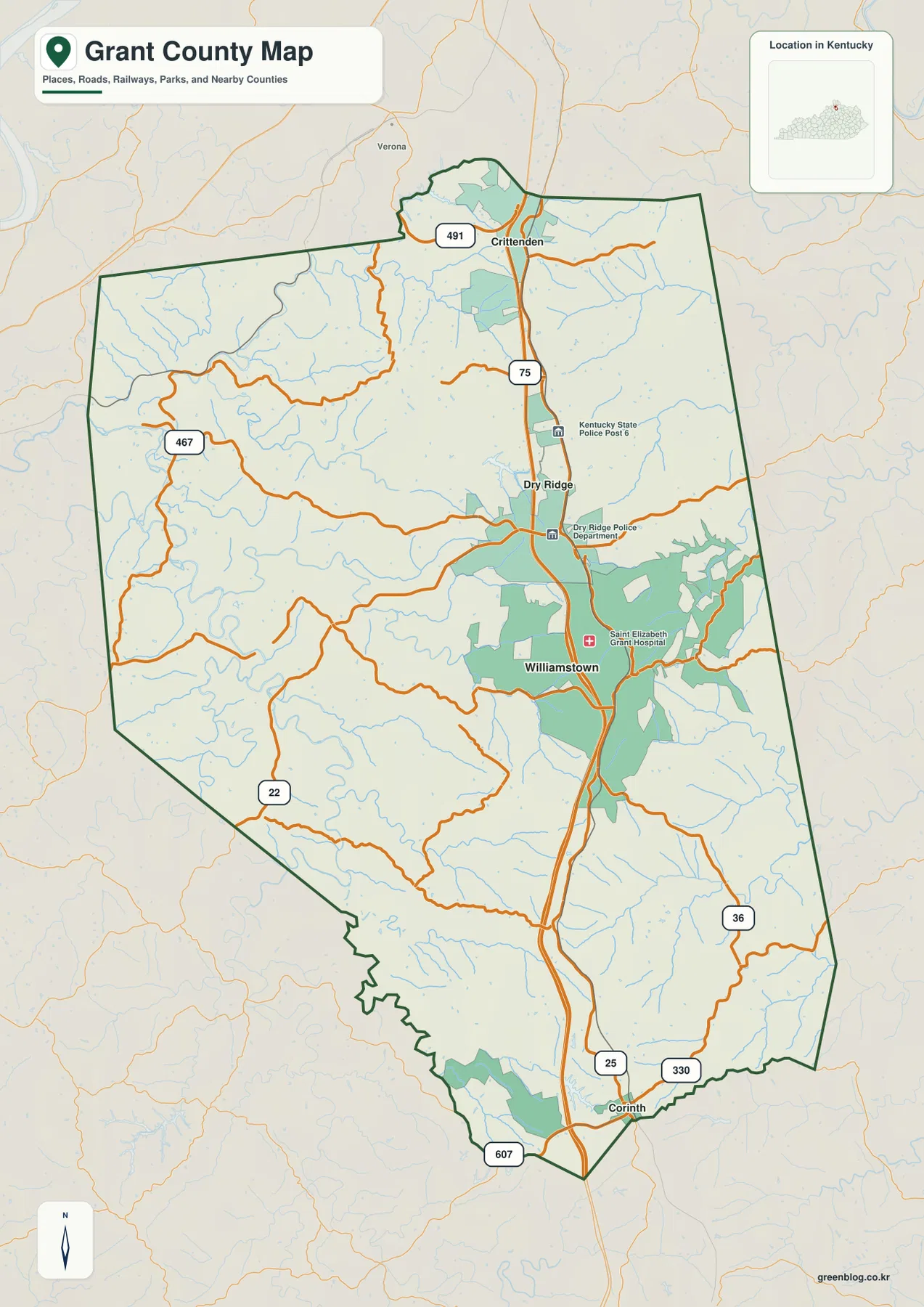
The city-connections layer uses Crittenden as the hub and reduces the county to four ranked city references. It shows Dry Ridge about 5 miles from Crittenden, Williamstown about 10 miles away, and Corinth about 20 miles away. These are straight-line distances between mapped city points, not driving distances, so they should be treated as a quick spatial comparison rather than a travel-time estimate.
The same layer displays population figures beside the four cities: 4,084 for Crittenden, 3,945 for Williamstown, 2,441 for Dry Ridge, and 226 for Corinth. The exact reference year is less important here than the visual hierarchy. Three of the larger places occupy the northern half and central I-75 corridor, while Corinth is a much smaller settlement near the southern boundary. That pattern is easy to miss on a detailed road map but becomes obvious on the simplified city layer.
Williamstown and Dry Ridge sit close enough that they often appear as the central pair when scanning the county, but Crittenden is distinctly farther north and Corinth clearly anchors the south. For a countywide trip, that means the I-75 direction is the first question to answer. Once the correct north-south position is established, the general map can supply the local route needed to reach the western or eastern interior.
Williamstown Lake and a web of creeks occupy the valleys between ridges
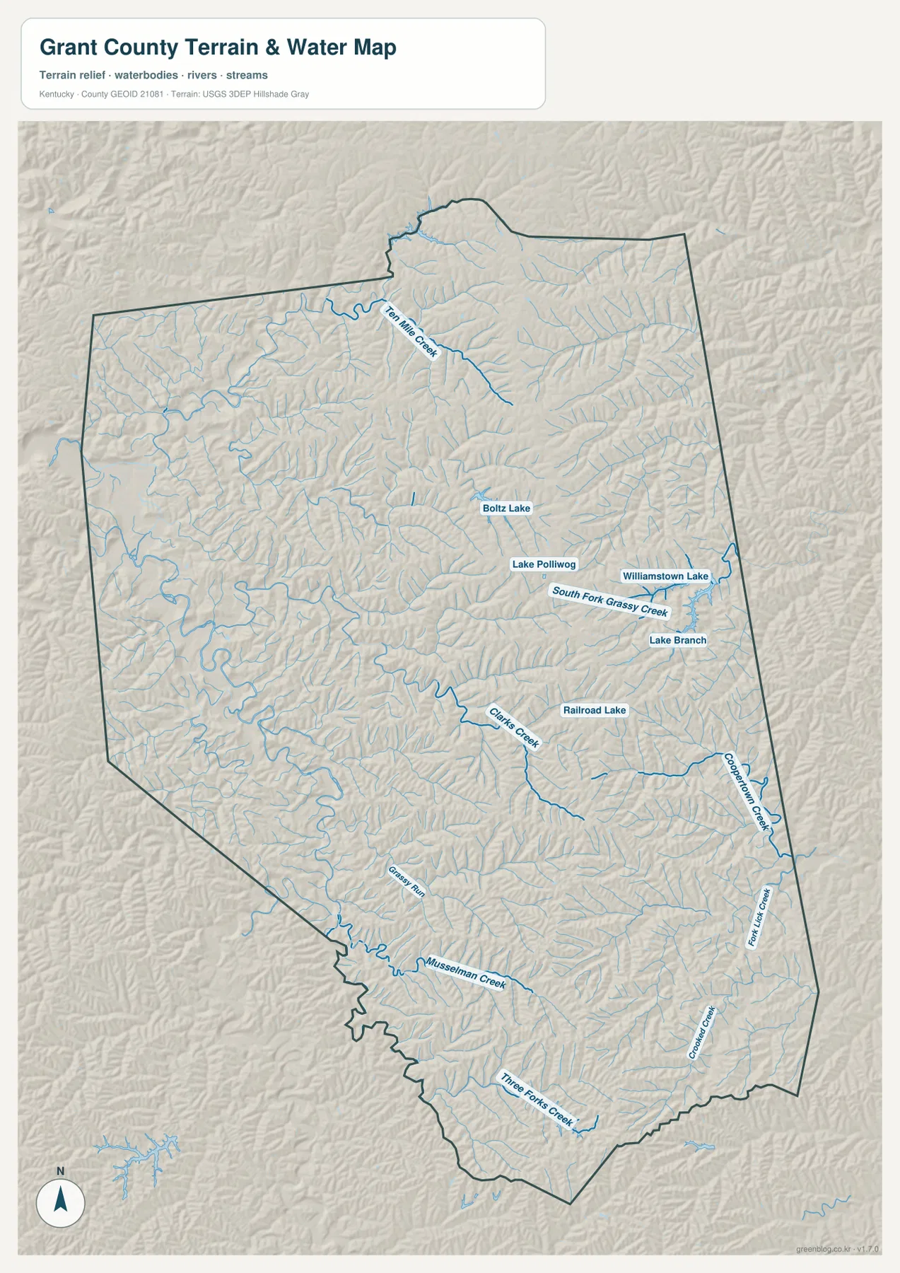
Williamstown Lake is the easiest water feature to identify on the terrain-and-water map. Lake Polliwog and Boltz Lake appear to its west, and Railroad Lake is labeled farther southwest. Grant County is not organized around one dominant river cutting through the center. Instead, a collection of small lakes and named creeks spreads across the county, providing a more detailed picture of the valleys that divide the rolling uplands.
Ten Mile Creek crosses the northern interior, while South Fork Grassy Creek and Lake Branch are labeled near the Williamstown Lake area. Clarks Creek runs through the central part of the county. Cooperstown Creek and Fork Lick Creek occupy separate eastern valleys, and Musselman Creek stretches across the southwest. Three Forks Creek and Crooked Creek add further references near the south. These names make the water layer especially useful when an address or rural road is easier to associate with a creek valley than with one of the four main cities.
The water features also explain the shaded relief. Grant County’s official site describes the area in terms of lakes, streams, ridges, and rolling hills, and the supplied map shows those elements closely interwoven. Small streams bend around ridges rather than crossing a flat plain, and the lower corridors often provide the gentler passages through the interior. This map is a static geographic reference, however, not a flood-risk, navigation, legal-water-boundary, or real-time stream-stage product.
The 163–305 m elevation range separates western lows from interior ridges
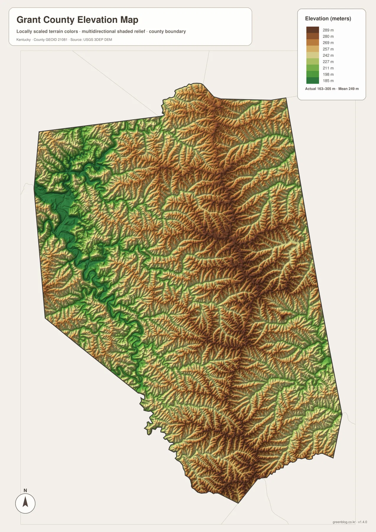
The elevation map reports an actual county range of roughly 163 to 305 meters, with a mean elevation of 249 meters. The lowest green terrain is concentrated in broader valleys along the western side and in parts of the southwest. These lower areas align with several stream corridors shown on the water map and create a noticeable contrast with the tighter ridge pattern in the county’s interior.
Moving toward the central and eastern sections, yellow, orange, and brown tones become more common. Short ridges are especially dense across the north-central, eastern, and south-central interior. Even the I-75 corridor between Crittenden, Dry Ridge, Williamstown, and Corinth does not cross an entirely flat landscape; the highway threads through rolling ground while smaller roads bend more noticeably around the hills and creek valleys.
This generalized elevation surface is intended for county-scale comparison. It is useful for distinguishing broad lowlands, creek valleys, rolling uplands, and higher ridges, but it is not survey-grade information for a parcel, building, road design, or engineering decision. Pairing it with the water layer is the most useful approach because many of the low green corridors correspond to named streams and lake basins.
Use the city corridor first, then add water and relief where detail matters
For a quick location check, start with the city map and identify whether the target lies closest to Crittenden, Dry Ridge, Williamstown, or Corinth. Then move to the general county map to add I-75, U.S. 25, and the appropriate state route. Around Williamstown, this sequence is particularly helpful because the city, highway corridor, and nearby lake system provide three different landmarks within a relatively small area.
For the western rural section or one of the smaller creek valleys, the water and elevation maps are more informative as a pair. Ten Mile Creek, Clarks Creek, Musselman Creek, and Three Forks Creek provide named valley references, while the color relief shows whether each corridor lies in a broad low area or between tighter ridges. Comparing those layers with the road map also helps explain why many local roads curve through the landscape rather than following a simple grid.
The downloadable JPG files are better suited to large printing than the WebP previews used in the article. Choose the general map for boundaries and roads, the city layer for settlement relationships, the terrain-and-water map for lakes and creeks, and the elevation map for countywide relief. Using the map that matches the question usually produces a clearer result than trying to extract every type of information from a single image.
Frequently Asked Questions
Which Grant County cities line up along the I-75 corridor?
Crittenden is near the northern edge, followed by Dry Ridge and Williamstown farther south, while Corinth is close to the southern tip of the county. The city-connections map uses Crittenden as the hub and shows straight-line distances of about 5 miles to Dry Ridge, 10 miles to Williamstown, and 20 miles to Corinth. Driving distances are different because roads do not follow straight lines.
Which map is best for finding Williamstown Lake and named creeks?
Use the terrain-and-water map. It labels Williamstown Lake, Boltz Lake, Lake Polliwog, Ten Mile Creek, South Fork Grassy Creek, Clarks Creek, Musselman Creek, Three Forks Creek, and other smaller waterways. The layer is designed for geographic reference and should not be used as a flood-risk or real-time water-condition map.
Where are the lowest and highest parts of Grant County?
The elevation map shows an actual range of about 163 to 305 meters with a mean of 249 meters. The broadest low terrain is concentrated mainly in western and southwestern valleys, while higher rolling ridges are more widespread through the central and eastern interior. The water map helps identify the creeks and small lakes occupying many of those lower corridors.
Map File Information
Download the Grant County general map, city map, terrain-and-water map, and elevation map as high-resolution JPG files.
- Included Files: county map, city map, terrain-and-water map, elevation map
Related Maps
Sources and References
For local context, see the Grant County Fiscal Court and its Grant County history page. Boundary and road references can be checked against U.S. Census Bureau TIGER/Line and Kentucky Transportation Cabinet printable maps. Water and elevation references are available from USGS National Hydrography and the USGS 3D Elevation Program.
Green Map creates custom-edited map images using open geographic data sources such as geoBoundaries, Natural Earth, OpenStreetMap, and government open data. These maps are edited visual materials, not raw data files, and are provided for education, documents, presentations, and graphic reference.